
 Explore Worlds
 Find Life
 Defend Earth


How do we see the surface of Venus from space?

Written by
Kate Howells
Public Education Specialist, The Planetary Society
December 29, 2023
Venus is good at keeping the secrets of its surface. The planet is perpetually shrouded in a layer of clouds, with an extremely thick carbon dioxide atmosphere. Observing Venus in visible light, those clouds are all you’d see.

Although four spacecraft have made it to the surface of Venus and survived long enough to return images, most observations of the planet’s surface have come from spacecraft in orbit. To see the surface of Venus from space, instruments must peer through the atmosphere.
Radar, for example, can penetrate the thick clouds to see the surface below. Imaging radar sends out pulses of energy in radio frequencies (also called radar signals). These signals travel through space and through the atmosphere, then bounce off the materials they encounter on the surface. The spacecraft then collects the signals that have been bounced back to it and analyzes them. Different materials — rock, liquids, ice, etc — reflect radar waves differently, indicating the characteristics of the surface. And based on the time it takes for the radar signals to travel to the surface and back, the data can show differences in elevation, allowing for a three-dimensional map.
Missions that have imaged Venus’ surface
Using radar imaging techniques, several missions have imaged Venus’ surface from space over the past 50 years.
In 1978, NASA’s Pioneer Venus Orbiter entered into orbit around Venus carrying 17 experiments, including a surface radar mapper. It used this instrument to examine the planet’s topography and surface characteristics, though not at high resolution.
In 1983, the Soviet Venera 15 and Venera 16 spacecraft arrived in orbit around Venus, equipped with more sophisticated radar imaging instruments. The images they returned had a resolution of 1-2 kilometers (0.62-1.24 miles), providing the first detailed maps of much of the surface of Venus and discovering massive, apparently dormant volcanoes.
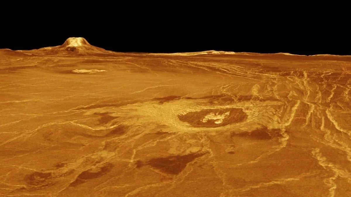
NASA’s Magellan spacecraft, which arrived at Venus in 1990, made the first global map of the planet. Magellan mapped 98% of the surface with a resolution of approximately 100 meters. The mission produced surprising findings about Venus, including a relatively young planetary surface possibly formed by lava flows from planet-wide volcanic eruptions.

The maps that Magellan generated are still the most detailed in existence — although other missions such as Venus Express and Akatsuki have studied Venus’ atmosphere and measured some surface characteristics like temperature, no other mission has conducted a detailed study of the planet’s surface topography since Magellan.
Upcoming Venus surface imaging missions
India aims to launch a Venus orbiter called Shukrayaan in December 2024 equipped with a radar and infrared camera to map the surface.
NASA's DAVINCI mission will launch no earlier than 2029. It consists of an orbiter and an atmospheric descent probe, and will take high-resolution images of Venus’ surface, particularly focusing on features called tesserae — strange, wrinkled landforms that we do not fully understand.
The European Space Agency's EnVision mission, which is set to launch no earlier than 2031, will send an orbiter to conduct a comprehensive study of Venus, from the core all the way to its upper atmosphere. The spacecraft will use a high-resolution radar to map surface landforms, including tesserae.
The most detailed surface mapping will come from NASA's VERITAS orbiter, which will launch no earlier than 2031. It will have a radar instrument with up to 100 times higher resolution than Magellan. This will give scientists highly detailed maps of the surface, providing valuable insights into Venus’ geology and evolution.

Protect Our Shared Future
You help us defend humanity and prevent asteroid impacts. Donate now to become a Planetary Defender!
Donate