A.J.S. Rayl • May 04, 2018
The Mars Exploration Rovers Update: Opportunity Studies Mystery Rock, Mission Officials Seek 2019 Extension
Sols 5043 - 5072
Opportunity spent April further exploring the area about halfway down Perseverance Valley, checking out unusual, vesicular or pitted rocks the likes of which she has never seen, while Mars Exploration Rover (MER) officials prepared the mission’s bid to keep the robot field geologist roving through 2019.
From Endeavour Crater’s west rim, the valley extends downslope, at about a 15-degree angle, for about 200 meters (about 219 yards) ending at the crater interior. Opportunity drove into the valley, which is within the Cape Byron segment, last July to study it and search for signs of anything in the morphology or shape of this place that can reveal what created it billions of years ago.
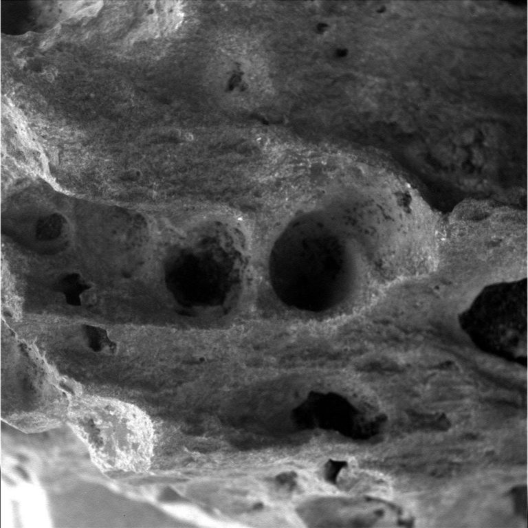
Although scientists exploring Mars never really know what to expect, as Opportunity hunkered down over one of the charcoal gray vesicular rocks at a site called San Juan Pueblo, they certainly didn’t expect what they found. At least most of them didn’t. And they’re not exactly sure what is means.
“Yes, this is new,” said MER Project Scientist Matt Golombek, of the Jet Propulsion Laboratory (JPL), home to all NASA’s Mars rovers. “It’s a very interesting rock,very unusual. We haven’t seen anything like this before.”
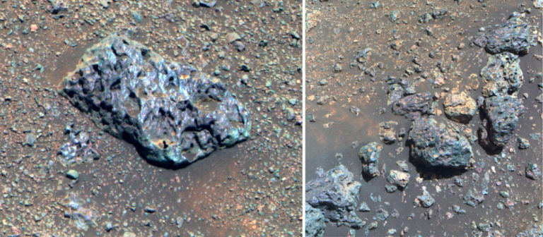
The vesicular rock outcrop that Opportunity looked at up close – and which the scientists thought could be a volcanic basalt rock – turned out to not be a volcanic basaltic rock. And they’re not exactly sure what it is. Hypotheses are being debated, new data is coming in, and analyses are ongoing. Just like Perseverance, the only geologic formation of its kind in the rim segments of Endeavour, this rock is a mystery.
This valley drew the scientists at first sight. In orbital images, Perseverance looks like a river system on Earth, complete with branches leading in different directions. As appealing as water on Mars is though, the MER science team from the outset has been pursuing multiple working hypotheses in its quest to determine its origin.
“It’s a work in progress,” MER Principal Investigator Steve Squyres of Cornell University, announced on March 22nd at the Lunar and Planetary Science Conference (LPSC) in Texas.
At that conference, six scientists offered up new findings from the rover’s latest data, along with evolving thoughts about what might have created or helped create this unique formation, covered in The MER Update Special Report. From the structure of the crater rim segments and their fault zones to the rare occurrence of the reactivation of certain faults and sand blasting of the valley by winds whipping up from the crater floor to an ancient lake that spilled over, and rocks that that hint of past water, they considered the hypothetical bases – wind, flowing water, debris flow, underground water, dry avalanche, and faulting – and left the doors open. All hypotheses are still on the table.
These weird rocks are yet another clue, perhaps even a geological doorway to the deep past. “The unique cut into the wall of Endeavour is exposing these rocks that we haven’t seen before,” said MER Deputy Project Scientist Abby Fraeman, of JPL-Caltech. “That has been really interesting and not expected and really cool.”

After inspecting targets at San Juan Pueblo during the first half of April, Opportunity roved upslope toward some tabular rocks, so named because of their tendency to separate into layers or plates, or laminae in geology jargon.
The Martian terrain made for some tricky, slope-slipping driving for the rover as she worked to get up to the tabular rocks. “Like a human would in the same place, the rover had some difficulty navigating the steep slopes, it seems because of a light layer of sand over rock,” said Chief of MER Engineering Bill Nelson, of JPL. “It took a couple of tries, but Opportunity still got to where she needed to be.”
“Oppy kept us on our toes,” said Rover Planner Paolo Bellutta, of JPL, “but as Steve Squyres always says: ‘Never bet against this rover.’”
On her upslope, Opportunity passed more vesicular rocks and passed the tabular rocks, and at month’s end wound up perched over one more vesicular rock to do some more research into what these things are.
There is so much more to see and so much more to know from this valley. Although there is never a guarantee of what will come next or what actually does await them at the end of Perservance, the mystery of this place will likely prove to be a complex one to unravel. The valley is old, two billion years or so old, so determining its origin is, at best, like putting together a huge, complicated 3D puzzle.
Never daunted, Opportunity is ready and all but bursting with energy. “Power is great, everything is great,” said MER Project Manager John Callas, of JPL.
The Martian spring moving in and the robot’s external wall temperature is warming to as high as -8 Celsius [17.6 Fahrenheit] during the day, and only dropping to around -80 Celsius [-112 Fahrenheit] at night, Callas said.
With almost sparkling solar arrays, whisked clean during the last several months by winds coming up from the interior of the valley, the rover is producing nearly three-quarters of her full power production capability on landing with clean solar arrays under slightly hazy skies. “Our intrepid rover is in excellent health and enjoying wonderfully high energy levels, among the highest energy levels recorded for this time of Martian year,” said Nelson.
On May 2nd, Squyres and Callas are scheduled to present the mission’s proposal before a Senior Review for an 11th mission extension, to keep Opportunity roving through 2019. As the process goes, the Senior Review will make recommendations to NASA officials, who, in turn, will make the final decision. [Beginning in 2020, NASA is to shift to granting mission extensions every three years as opposed to every two years; hence, this extension will be for just one year.]
For years Opportunity and the MER team have cruised Mars comfortably, though sans bells and whistles, setting records and making textbook-changing discoveries on about $14 million annually. For the tenth mission extension (2016-2018), the budget was cut lean, to less than $13 million. Now the maximum funding that would be allotted for 2019, is further reduced, to $12 million, according to one source.
It’s a budget cut that will likely impact operations and there is, apparently, no negotiating room. Even though this smart ‘bot is 171 months into what was originally slated as a 3-month tour and is still pioneering planetary exploration, still going where no rover has gone before, and still blazing trails for future Mars explorers, robot and human. Even though Mars exploration has dramatically increased in popularity and believability in large part because Spirit and Opportunity sent the Red Planet home, in breathtaking images of landscapes that seem somehow familiar, and stunning images of dawns and dusks, skies of pink, and rust red dunes. And even though this rover is now on the first-ever exploratory cruise through the rim of a large, ancient impact crater, pushing the limits of an adventurous expedition of discovery that has established and broken so many records, and uncovered more of Mars’ secrets than any other surface mission.
The plan for 2019 is to keep roving along the tenth mission extension route, which will take Opportunity down to the interior of the crater, to the benches nearby, and, grim-budget-reaper willing, back out of the crater farther to the south. “We want to complete that plan,” said Callas. “We are privileged NASA officials are talking about giving us another year of funding.”
Optimism, gratitude, and living the mantra “Every day on Mars is a gift,” are assets that throughout the years appear to have helped fuel this team. Those assets are still very much alive and roving alongside Opportunity on Mars.
Deep Dive into April
Opportunity woke up to April at San Juan Pueblo, an outcrop of dark glassy rocks chock-full of holes, what geologists call vesicular rocks. Located in the southern border area of the south trough, the site is named for a stop along the El Camino Real de Tierra Adentro, the old, 2,560-kilometer (about 1,591-mile) trade route between Mexico City and San Juan Pueblo, New Mexico.
The team adopted this naming theme once the rover entered Perseverance Valley last July. The Spanish Southwestern history theme the mission is using right now for naming rocks and outcrops is worth pointing out again. “To my knowledge, this is the first time that Hispanic names and history have been used in any mission,” said MER Athena Science Team member Larry Crumpler, a research curator at the New Mexico Museum of Natural History and Science, and Associate Professor, University of New Mexico.
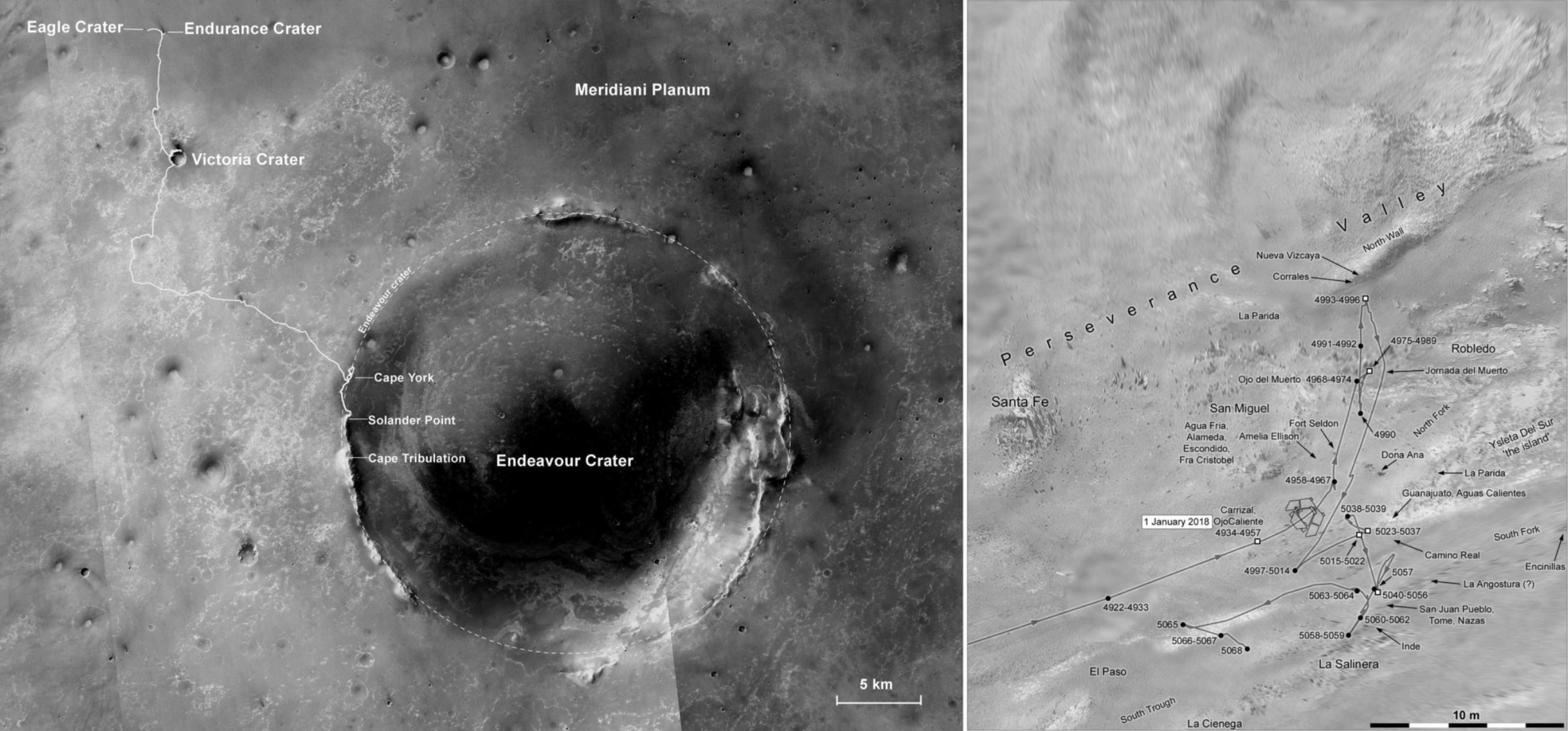
Boasting a solar array dust factor of 0.836, the robot was producing about 680 watt-hours under hazy skies, with a Tau recorded at 0.653.Opportunity had just completed a multi-drive bump toward a target of vesicular rock on Sol 5040 (March 29, 2018) pushing her total odometry to 45.13 kilometers (28.04 miles).
When the rover’s post-drive images arrived on Earth however, the team discovered that the rover had slipped below the intended target. That meant the robot would have to make a large turn in place to reach the rock. Given that Opportunity is now steering only with her rear wheels and because on second look the intended target did not appear to be a good candidate for a deeper look with the Rock Abrasion Tool (RAT), the team decided to direct their field geologist to a target of opportunity already in the Instrument Deployment Device (IDD) or robotic arm work volume.
On Sol 5043 (April 1, 2018), Opportunity performed an overnight integration on the chosen spot, named Tome, with her Alpha Particle X-ray Spectrometer (APXS) to analyze its chemical composition, no kidding. Opportunity then took the pictures needed for a Microscopic Imager (MI) mosaic of Tome on Sol 5045 (April 3, 2018), and then followed that with the now-standard protocol of again placing her APXS on the target.
Throughout just about every working sol or Martian day, Opportunity also took the usual Navigation Camera (Navcam) and Panoramic Camera (Pancam) images of other chosen targets and targeted and panoramic images of the surroundings. There were even sols, like 5046 (April 4, 2018) where the rover multi-tasked, taking a Pancam panorama while deploying the APXS to “sniff” the chemistry of Tome.
On Sol 5047 (April 5, 2018), Opportunity offset her APXS on the target for further chemical analysis while continuing her imaging campaign of the San Juan Pueblo site. Then in order to better reach nearby targets, the rover made a small 2-degree, turn-in-place on Sol 5049 (April 7, 2018), to be able to zero in on a spot the team named Nazas.
During the second week of April, Opportunity spent several sols taking more targeted and panoramic imagery with her Pancam, working in an atmospheric argon measurement with her APXS on Sol 5050 (April 8, 2018), and finishing up the in situ investigations on the shoestring pattern of vesicular rocks on the floor of the valley. “It looks like outcrop and is strung out all along this southern border of the south fork,” said Golombek.

By Sol 5053 (April 11, 2018), after a final MI mosaic and placement of the APXS for a multi-hour integration, the rover’s work at Nazas was finished. Opportunity refocused and spent the rest of the second week of the month, Sols 5054-56 (April 12-14, 2018), remote sensing, taking multispectral images with all 13 filters of the Pancam of chosen rocks and outcrop.
“These are the first vesicular rocks that Opportunity has seen anywhere on the entire mission,” reminded Golombek. “Most of the time, vesicular rocks are volcanic rocks and the gas bubbles in the lava is what produces the vesicles. Basalts are pretty common. Many of us were pretty interested in these, because the first take is the dark gray and they are vesicular – so maybe they are basalts.”
That would be a significant discovery actually, because Opportunity has not seen any primary basalt flow material at Meridiani Planum even though the surface is covered with meters of basaltic sand. “We don’t know where that basaltic sand came from,” said Golombek. “We have no protolith that we’ve seen anywhere around the route, so this is interesting for sure,” he said. [A protolith is the original, unmetamorphosed rock from which, in this case, basaltic sand formed.]
The analyses of Tome and Nazas and extrapolations to the vesicular rock outcrops are ongoing. What the scientists do know is as intriguing as what they don’t. “It’s definitely not basalt,” said Golombek. “It is higher in silica and it has an unusual composition that is not like most of the things that we’ve seen. There are some rocks that have portions of the elements that are similar to what we see here, but not others.”
Moreover, some of the vesicles look like they’re filled “with other material,” said Golombek, “different, maybe after-growth minerals or something.” In some cases, “it almost looks like there’s a film on the inside of the vesicles, which might have happened from alteration or something, so it’s a very interesting rock,” he reiterated. “The chemistry and the textures are different than anything we have seen in the rim of in Endeavour and in the Burns Formation,” Fraeman elaborated.
It’s another Martian mystery for now. “The location at San Juan Pueblo, where we were we could get two APXS spots, aren’t very big,” Golombek said. Nevertheless, this shoestring shaped bounty of seemingly vesicular rocks is a new kind of outcrop. Even as the rover departed San Juan Pueblo, the scientists added inspecting another one up close to their ‘lean list.’

Meanwhile, they are debating the possibilities. One possibility is that these dark, glassy, unusual rocks, as Crumpler theorized during the Lunar and Planetary Science Conference in March, may be impact melt that date to the Big Thunderous Thud that created Endeavour.
Opportunity had been en route to these vesicular rocks in the latter half of March as scientists were presenting some of the recent findings from Endeavour. From images then in hand, Crumpler suggested during his talk that these oddities may be may be pseudotachylites, a type of fault zone melting generated at the time the crater formed, from intense throw and frictional heat within fractures.
As the rover got up close to and studied the vesicular rocks in April, he confirmed the “vesicular rocks are right between two fractures” that “are parallel to all the other indications of fractures in the valley.” This would certainly seem to support his hypothesis that Perseverance was strongly fault controlled, as well as his suggestion that these rocks may be impact melt.
Still, the research is ongoing and there are other possibilities being presented and debated. There’s also a hypothesis MER Athena Science Team member Jim Rice, Senior Scientist at the Planetary Science Institute, presented “that weathering of rocks can some times form this unique kind of texture,” Fraeman said. “You see it really dry places on Earth. There are rocks in the Antarctic that get these textures. So is it a weathering thing? Are they some sort of melt?”
Another possibility in the ether is that these rocks may not be rocks at all, at least in the sense of being a single thing. Instead, they could be made up in large part of coatings - perhaps very thick coatings on underlying rock, what geologists call ‘case hardening,’ which have somehow eroded to these unusual textures.
“We want to get more chemical information and then context of nearby rocks as well to see if there’s anything we can glean from those,” said Fraeman. “If they’re related to the nearby rocks, that may tell us something.”
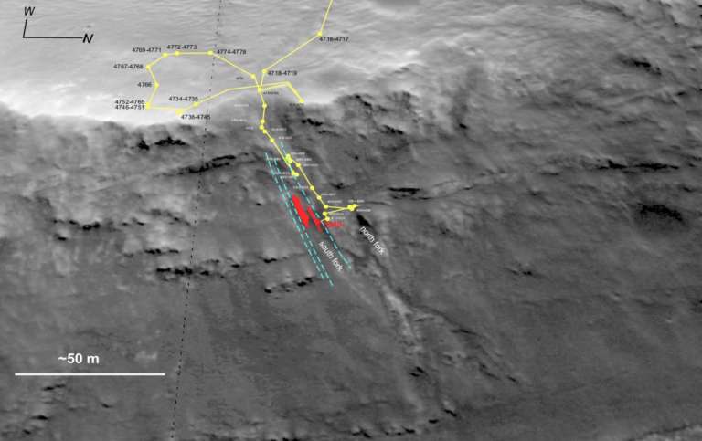
In the meantime, Oppy roved on, heading toward a bank of tabular rocks a few feet upslope that had grabbed the scientists’ attentions. With the research on Tome and Nazas complete, the plan was for the rover to back up and scoot upslope to the tabular rocks.
As the third week of April began on Sol 5057 (April 15, 2018), Opportunity initiated that plan. The rover backed up and turned just about 4.5 meters (14.76 feet) to set up the approach for the upslope run to the tabular rocks. Although it was just a turnaround, the rover took the usual post-drive Navcam panoramas as well as some targeted 13-filter or multispectral Pancam images, which helps scientists determine mineraology.
The next sol, 5058 (April 16, 2018), Opportunity put her pedal to the metal and went for it, trying to zip straight upslope to the tabular rocks. “That did not work at all,” said Bellutta.
The robot did manage to put 2.97 meters (9.74 feet) meters behind her and she did snap the routine post-drive documentary imagery, so all was not lost, but the terrain was just too slick with sand and pebbles. “We couldn’t get to the tabular rocks from that approach,” said Golombek.
Actually, MER class rovers have demonstrated better climbing performance driving backwards uphill. “But that required almost a 180 degrees turn, which I thought was going to upset Oppy,” said Bellutta. So he and RP Hallie Gengl spent days contemplating the forthcoming drive, and learning again that waiting is the hardest part.
Sol 5059 (April 17, 2018) was designated a remote sensing sol, wherein the rover would basically take images. But the Deep Space Network station's transmitter was flagged red – meaning it was not operational. That meant Opportunity never received her commands. Instead, she exercised the onboard run-out sol and the team got 100 megabits of downlink data that was all fill because the rover didn’t do anything. “Bummer,” said Golombek. “But these things happen.”
Nominal planning was scheduled to resume with Sol 5060 (April 18, 2018) however, and it did. Opportunity backed up 1.13 meters (3.70 feet) so the RPs could assess.They assessed the rover should take a different, less difficult route to the tabular rocks.
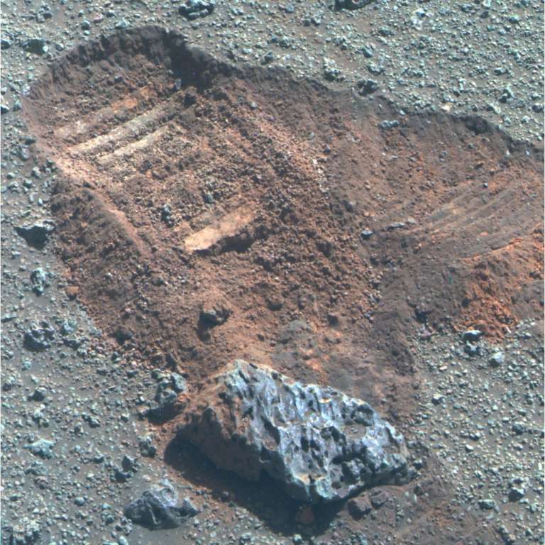
“We backed up and we noticed there was this scuff where the rover wheels had gone over and there was some lighter toned material,” said Golombek. “There was no RP available April 19, 2018, so Opportunity spent Sol 5061 (April 19, 2018) taking images.
The thing is and always was that there are usually more rocks or outcrops or soil patches or other Martian oddities than can be fit into the rover’s schedule and so Opportunity didn’t look at the light-toned material up close. “The tabular rocks were viewed as more important,” Golombek said.
On Sol 5063 (April 21, 2018), Opportunity turned to position her back to face uphill, putting 2.79 meters (9.15 feet) on her odometer in the process.
“On Monday [April 23rd], Hallie and I prepared the Sol 5065 drive to climb straight uphill,” said Bellutta. “I was not confident at all this was going to work as there were some indications from the previous drive that we would have lots of slip.”
Opportunity does love to rove though and just like that, she cruised backwards uphill, putting 11.02 meters (36.15 feet) in the rear view mirror, passing right by some more vesicular rocks. While she did slip a bit, it wasn’t “beyond what the rover could tolerate,” Bellutta said.
The drive actually went so well it took the rover right past the tabular rocks, “to a standoff location to approach the science targets from above,” confirmed Bellutta.
Opportunity then inched slowly downhill on 5066 (April 24, 2018) for 2.17 meters (about 7.12 feet). In the meantime, the vesicular rocks were continuing to intrigue the scientists. They decided since there were good samples of these rocks pitted with holes on the rover’s path, the ‘bot would first examine one of them before getting into the tabular rocks.

As a result of extremely poor data return on the UHF pass, Opportunity had a leisurely hump day on Sol 5067 (April 25, 2018), taking a Tau measurement and attending to some routine engineering tasks before calling it a sol. Since the robot is working in RAM and her Flash drive is no longer dependable, the robot has no non-volatile drive to store data. Since RAM is volatile memory, when the rover shuts down for the night, all data is deleted; therefore, all the work collected in a given sol must be downlinked the same Martian day.
On Sol 5068 (April 26, 2018), Opportunity took the usual pre-drive imaging, this time of the foreground to the south and of the tabular rocks, which were farther out to the south, and then inched downslope again this time for just 1.79 meters (5.87 feet) to the southeast. She was to position herself at the next IDD target, a pitted rock christened Allende, after the stop on El Camino Real de Tierra Adentro (not the Chilean president).
Because of slip in this very high tilt region however, the ‘bot did not quite reach the desired location. And because extremely poor data return on the UHF pass, Opportunity had a simple Sunday of measuring the Tau and checking off some engineering tasks.
On the morning of Sol 5070 (April 28, 2018), Opportunity completed a turn in place, to try and get right where the team wanted her to be.But, again, the slip in this high tilt region prevented precision maneuvering. The team deemed her position good enough and the robot focused her Pancam on Allende and took a multispectral quarter frame of the target.
Pancam multispectral imaging has enabled important insights about the geology and geologic history of Mars, and Pancam observations from near-UV to near-IR wavelengths provide limited compositional and mineralogic constraints on the presence abundance, and physical properties of ferric- and ferrous-iron bearing minerals in rocks, soils, and dust.
The next sol, 5071(April 29, 2018) turned out to be another lite one, again because of extremely poor data return on the UHF pass, and againthe robot field geologist took a Tau measurement and handled engineering duties.
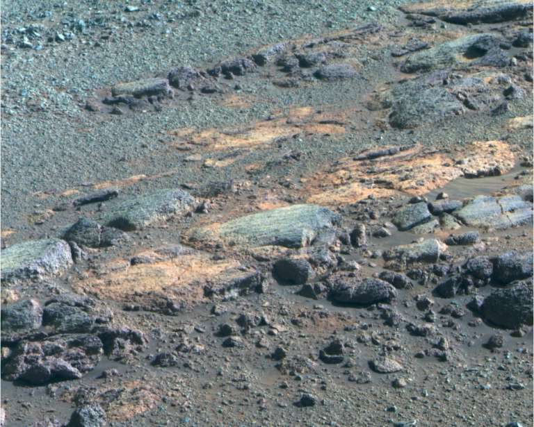
Opportunity spent the final day of April checking out Allende, completing MI stereo imaging, and placing the APXS on the target for an evening integration on after the UHF pass, and was slated to continue the science campaign on this vesicular rock for another sol or two. Once her work is done there, the “next stop will be the tabular rocks,” said Golombek.
The rover’s truly excellent power production is expected to stay on trend, at least in the short term. “I actually today suggested to the team that we need to do things to use up some of this excess energy because we’re fully charging the batteries everyday and the lithium ion batteries don’t like to be fully charged,” said Callas. “We have enough energy to do overnight activities so let’s do some.”
So the ops team is now discussing how to take advantage of the bounty of energy. Since using power warms the rover and because spring is moving in and the rover is warm enough, they want to use this energy at a time when the rover is cold. “That’s why using it at night is advantageous,” said Callas.
Opportunity has already been doing more late night atmospheric measurements of argon for a mission long study, but the team has started looking into astronomical observations for the rover to try and photograph. Using up this excess energy by working late helps the robot in a couple of ways.
“When the batteries are fully charged, the excess solar array energy we get gets dumped into the shunt heaters, which gets dumped into the rover, which warms the rover up,” explained Callas. “What I want to do is do some overnight activity so we take energy out of the batteries and put it all back in the next day when we charge up. Instead of energy going into shunting, we put it into the previous night’s activity.”
As April gives way to May, Perseverance Valley is looking to be an increasingly complex story. “It could be a multitude of processes that carved this,” said Fraeman, echoing the opinion of many on the team. “We see a lot of things that are consistent with this area being heavily fractured, and so that may be the simplest explanation for the origin of Perseverance at this point. But we’re looking to get to the bottom of this thing and exploring all the possibilities.”


 Explore Worlds
 Find Life
 Defend Earth

