
 Explore Worlds
 Find Life
 Defend Earth


Curiosity Update, Sols 2313-2387: Two New Drill Holes Despite Memory Problems
Written by
Emily Lakdawalla
April 25, 2019
The Curiosity team is touring Glen Torridon, the Valley of Clay, south of Vera Rubin Ridge, happily photographing everything and zapping rocks. It’s clearly a delight for the team to be in a place they’ve been hoping to reach for 7 years. Their enthusiasm was dampened for a few weeks by annoying memory problems in both rover computers. Despite these challenges, the team succeeded in drilling into very soft rock at Aberlady on sol 2370. Aberlady was Curiosity’s 20th successful drill site and the 5th since returning the drill to function. For reasons I’ll explain below, they drilled a second time quite close to Aberlady, at Kilmarie, on sol 2384.
Fun Rocks in Glen Torridon
The rocks around here are really fascinating. First of all, there are the pebbles. They’re everywhere underfoot, sitting on top of sand. That configuration means they’re likely a lag deposit—sand is being removed by wind, but the wind doesn’t move the pebbles. Over time, the pebbles get concentrated until, in places, they almost completely cover the sand. Curiosity gathers systematic data on the surface materials, taking a photo using its downward-pointing MARDI camera at nearly every drive stop. MARDI’s observing geometry is almost exactly the same every time, looking at a patch of ground about a meter wide, so you can directly compare the sizes and shapes of pebbles from one drive stop to the next.

Once in a while, the pebbles get truly weird-looking, and sometimes the team has taken the arm out to investigate them with the high-resolution MAHLI camera on the end of the arm. This particular photo inspired a lot of conversation when it was first returned to Earth because of the notable roundness of the pebbles. I like the one that looks like an olive or a bead at lower right, with a hole in the center. It’s about 1.8 millimeters across — just a little smaller than a standard-size, 11/0 glass seed bead. Amazing.

The outcrops are also weird-looking. They seem to be made of very thinly layered rock, like the Murray mudstones Curiosity’s been looking at for a long time, but they’re weathering in a different way. I’m very curious to learn what makes these rocks different from previously-examined ones. Take Fife:

Or Muir of Ord, which reminds me of the Millennium Falcon, junked in the Jakku desert:

But the rover kept driving in order to reach the lowest-elevation outcrop in Glen Torridon, because if you’re a geologist reading rocks, it’s best to start the book at the beginning, which is the lowest-elevation outcrop. The lowest-elevation area in Glen Torridon coincided with a spot that displayed an especially strong signature of the presence of clay minerals as seen from orbit, so the team hoped they’d find a drillable outcrop there.


Indeed, the Aberlady outcrop, which they reached on sol 2364, looked very drillable:

By the time they reached Aberlady, the team had begun to get a handle on the rock diversity within Glen Torridon. There’s a lot of variability in the rocks, but most of them can be lumped into three subunits. One a type seen around Knockfarril Hill, in the early part of their traverse into Glen Torridon, which is cross-bedded: the angles of the beds intersecting with each other mean that their grains were laid down by flowing wind or water. The other two are both finely laminated mudstones, the kind of material that settles out of very still water. They drilled at Aberlady as a representative member of one of those two mudstones.
Drilling at Aberlady was easy—too easy, as it turns out. The drill penetrated the rock so easily that it needed to use no percussion at all; Aberlady was Curiosity’s first rotary-only drill site. (Read here for more about rotary-only drilling.) Awesome! But look what happened when they pulled the drill out of the rock. The whole rock lifted up. Had they drilled all the way through a loose rock to sand below? Was there even sample in the drill?
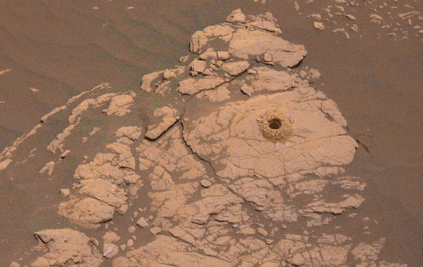
Since this was such an important rock unit, the team had planned to put the sample into a fresh, never-used sample cell on CheMin. They adjusted their plans and delivered to a used cell. They got good data, but further testing made the team doubt that there was enough sample in the drill to deliver to SAM. There’s no way for the SAM instrument to measure whether it receives any sample at all, so that was too much uncertainty. They decided to dump the sample (on sol 2377) and on sol 2381 they bumped a short distance to a second drill site, Kilmarie, located only 80 centimeters away from Aberlady. The drilling was successful and the rocks didn’t shift, so hopefully they’ve gotten the sample they need and can move on to sample the other rock types they have identified in Glen Torridon.

Memory Challenges
I don’t have much to tell you about the memory issues that Curiosity experienced last month. To recap, the recent issues began with a serious problem with the non-volatile memory in its B-side computer on sol 2172 (15 September 2018). As the team continued to troubleshoot the B-side problem, they switched operations over to the A-side computer, returning to operations on sol 2204. The A-side computer hadn’t been used for nearly 2000 sols, and things were fine at first. But on sol 2321, the A-side computer had a problem. That problem bore similarities to the B-side computer problem, but it wasn’t as serious, and the team recovered operations on the A-side computer by sol 2332. Unfortunately, a week later, on sol 2339, the A-side computer experienced another problem.
In the meantime, the team had managed to partition off the part of the memory on side B that had been involved in the B-side computer issue, so the B-side computer was once again available for backup. They returned to the side B computer on sol 2347 and things seem to have been fine on that computer for a month. I’ll try to find out more about what’s up with the memory issues for a future update.
Eclipse Season
A random fun thing to end this post: It’s eclipse season again on Mars. Twice a year, there are periods when Mars’ moons Phobos and Deimos transit the Sun as seen from Gale crater. Scientists watch these in order to precisely time Phobos and Deimos’ orbits, to see how they’re evolving. Scientists also watch them because they are cool. To learn more about how and why scientists shoot photos of Phobos and Deimos eclipses from Mars, check out this Mars Exploration Rovers update featuring lengthy commentary on eclipse observations from Mark Lemmon, who also organizes Curiosity eclipse observations. And enjoy these time-lapses!


And now, here are all the official Curiosity mission updates from this period.
Sol 2313-2314 update by Scott Guzewich: Cruising the Clay-bearing Unit (6 Feb 2019)
Curiosity is cruising through the clay-bearing unit on some compacted clast-rich soil, seen in this capture from Navcam. It's some of the best driving terrain we've encountered in Gale Crater, with just some occasional sandy patches in the lee of small ridges. Our route will take us northward along the east and south flank of the Vera Rubin Ridge toward our anticipated first drilling stop in the clay-bearing unit. Along the way, we're stopping regularly for "touch-and-go" contact science, including in today's plan. Given the lack of even modest size rocks or bedrock outcrops nearby, we targeted a small soil patch termed "Alba." We also will use ChemCam and Mastcam to interrogate the area around Alba, in addition to some geologic targets both near and far.
Now that we're driving along the edge of the Vera Rubin Ridge, it blocks our view of the dune fields to the north and west that were our preferred targets for observing dust devils. In today's plan, we'll look toward Mt. Sharp (toward the east-southeast) with a long-duration dust devil movie to see if that area may also be conducive to dust devils.Sol 2315-2317 update by Susanne Schwenzer: Exploring the New Terrain - One Measurement at a Time (11 Feb 2019)
Image taken by the Left Navigation camera onboard NASA's Mars rover Curiosity on Sol 2313 (2019-02-07 15:05:46 UTC) during the observation of the target "Alba."
Curiosity is driving across the clay-bearing unit, which is still a very new terrain with many details yet to be understood. The region is covered in little pebbles - and has lots of small sand patches, too, both of which we continue to investigate. The Navigation camera image above shows the APXS being deployed on the sand patch Alba that was investigated on sol 2313. After that, the drive took us a little further north, to be exact, Curiosity drove 39 metres from the last location.
The parking location presented us with the same pebbly-strewn surface as before, with the occasional small sand feature. With this terrain being new, and some small-scale sedimentary features spotted by the eagle-eyed sedimentologists on the team, we decided to use ChemCam on three pebbly targets, "Dauntless," "Otter," and Thistle." The team also found - for the first time in this new unit - a pebble large enough to get a full APXS raster on one continuous piece of rock. Yes, this is how small the pebbles are! We used the opportunity, named the target "Emerald," and investigated it using a 3-spot APXS raster, accompanied by MAHLI observations on this target. To put all the small pieces into context, we planned a large Mastcam multispectral raster investigation covering the workspace in front of the rover, and including the targets "Dauntless," "Faoilean" (a sand patch), and the APXS target "Emerald." It also covers some of the sedimentary details that were spotted in the post drive imaging. Two further Mastcam observations target aeolian features (target "River Brora") and a small ridge ahead of the rover, named "Osprey."
ENV included atmospheric opacity measurements with both Mastcam and Navcam, as well as cloud observation movies and a dust-devil survey in our weekly morning suite. Now that the regional dust event has declined, we are seeing an uptick in dust devils!
The drive is targeted towards a small outcrop - the largest piece of continuous rock so far seen in the new terrain. Go, Curiosity, geo-minded Earthlings will love to get close and personal to an outcrop soon again!Sols 2318-2319 update by Lucy Thompson: Touring Glen Torridon (11 Feb 2019)
Left Navigation Camera image of the Glen Torridon area. The bright exposure of rock in the foreground is the top of the area being interrogated by the contact science instruments in the plan tosol. This gives way to the rubbly and sandy terrain in the background, with a few areas of bedrock exposure, flanked by the southern edge of the Vera Rubin Ridge behind.
Similar to its namesake in Scotland, the Glen Torridon area on Mars affords us stunning vistas, but in our case, of the relatively low-lying clay bearing (from orbit) unit flanked to the north by the higher ground of the Vera Rubin Ridge and to the south, by Mount Sharp. We have been capturing the views with our cameras, Mastcam, Navcam and Front Hazcam and stopping for a taste of what this area has to offer by analyzing the local terrain with our suite of contact science instruments, as well as with ChemCam and Mastcam. The plan tosol is no exception.
The drive we took over the weekend, went off without a hitch and placed us on one of the few examples of more coherent, in-place bedrock exposures in the area. As such, we decided to put the brakes on and take some time to investigate in more detail. We will deploy the arm to first brush a typical area of this bedrock "Curlew," in an attempt to remove as much of the Mars surface dust as possible, before taking some close-up images of the target with MAHLI and then analyzing it for chemistry with APXS. The arm will also place us to take close up MAHLI images and obtain chemistry with APXS of another slightly different looking area (colour and texture) of exposed bedrock ("Gannet"). To complement these observations, we also planned ChemCam LIBS on the "Gannet" target, and Mastcam multispectral observations to cover both targets to look for spectral variations across the outcrop. ChemCam will also investigate the composition of 2 other bedrock targets ("Beryl" and "Ladyburn"), and a pebble target ("Southness") with LIBS and we will increase our colour image coverage of this exposure with Mastcam. DAN active and passive measurements were also included to investigate the distribution of subsurface hydrogen in the bedrock and regolith.
We also planned a large Mastcam mosaic to capture the view out the front window. It will include the cliffs of the Vera Rubin Ridge as well as the drive direction, which is a mixture of rubbly rock and sand and low-lying bedrock exposures, one of which ("Midland Valley") we hope to drive to next.
The data we collect will help us to compare the Glen Torridon area with other regions we have encountered on the mission; specifically the rocks we analyzed on the Vera Rubin Ridge, as well as the other Murray formation sedimentary rocks we encountered prior to the Vera Rubin Ridge. It will also allow us to place this area in context as we continue to climb Mount Sharp.
Curiosity is also monitoring the environment as she tours Glen Torridon. We included standard background REMS activities that monitor the daily martian weather, two Navcam dust devil movies and a Navcam dust devil survey. We also continue to monitor the radiation environment with RAD.
A fun, busy day of planning on Mars with lots of great observations. Not only did I monitor planning activities in order to write this blog, but I also got to choose some of the targets we ended up analyzing, and as the APXS payload uplink and downlink lead, I am in the process of preparing the commands that will be sent to the rover to execute our planned measurements on Mars. I also got to check that our instrument was healthy and ready for planning today after the weekend activities.Sols 2320-2323 update by Catherine O’Connell-Cooper: Onwards to Midland Valley (14 Feb 2019)
Front Hazcam image, showing the current workspace. This is a block of more coherent bedrock, surrounded by rubbly terrain, with lots of small rocks, pebbles and sand.
Today was a very busy planning day for the Curiosity operations team. We planned a 3-sol plan, with contact science, imaging, environmental monitoring and a drive.
Our weekend plan brought us to a block of coherent rock, a treat after spending many workspaces in more broken up and rubbly areas. The Geology (GEO) theme group uplinked lots of contact science here on Monday, so we are ready to leave and drive on to the next coherent block we have identified in the distance, a target known as "Midland Valley." Before leaving however, we planned contact science on "Ladder Hills," a beautiful example of laminated bedrock. APXS will be used to determine the chemistry, to compare it to our other targets in this workspace "Gannet" and "Curlew." MAHLI will take images of the laminations within Ladder Hills from two different angles - straight downwards onto the rock surface (the spot where APXS will also analyze), and from an oblique angle. ChemCam will acquire active LIBS (laser) analysis of Ladder Hills, in addition to analysis of "Fyvie," a large pebble for comparison with bedrock targets.
The plan features lots of Mastcam imagery. Both Fyvie and the post-drive AEGIS target will be imaged, in support of ChemCam science activities. Two mosaics will focus on the laminations in the workspace, in the targets Ladder Hills, "Ladyburn" and "Loch Gelly." Multispectral documentation will be taken of the Curlew target, which was brushed in Monday's plan. There is a mosaic of two linear ridges in the distance ("Gilles Hill").
Mid-way to our next stop at Midland Valley, we will stop at a small ripple field. Using Mastcam, we will image the undisturbed sand, before scuffing using the right wheel, back away a little, and then take another Mastcam image of the disturbed sand. These images will be used to further characterize the physical properties of the sand in this area. Then our drive resumes, hopefully ending on bedrock for our upcoming weekend plan. Following the drive, APXS will do overnight measurements of argon in the atmosphere, as part of a long range experiment looking at changes in argon abundances and seasonal variations.
In parallel to the very full GEO plan, the Environmental (ENV) theme group also has a very full plan. The main ENV activity is a ChemCam Passive Sky observation, which lets us measure the column abundance of water vapor, oxygen, water ice and dust in the atmosphere, and also gives us some idea of dust and water ice particle sizes. This is particularly interesting as we just had some regional dust storm activity on Mars, so there's still quite a lot of dust in the atmosphere above the rover. For this reason, we're also very interested in the two Mastcam atmospheric opacity measurements in this plan, which will tell us how much dust is still up there; recently, opacities have been trending down. ENV planned some Navcam movies, as part of an ongoing campaign to examine martian clouds, their properties and abundances. The "zenith" movie looks directly upwards to look at clouds and their direction, whilst the "suprahorizon" movie is targeted in a more horizontal direction, looking at clouds and variations in optical depth in the atmosphere above the north rim of the crater. ENV also planned Navcam and Mastcam "dust devil" movies and surveys, which measure the number, location, and characteristics of dust-filled convective vortices, which in turn tells us about surface heating, convection, and winds near the surface. These observations are targeted lower than the suprahorizon movies, to search for dust devils across the crater floor on the slopes of Mount Sharp. Excitingly, this plan sees the very first use of Mastcam to take a dust devil movie, which will give colour images and better resolution (although over a smaller region) than Navcam. Finally, there were also standard RAD, REMS and DAN activities.Sol 2333 update by Melissa Rice: Back in action at Midland Valley (28 Feb 2019)
Image of the "Midland Valley" outcrop taken by the Left Navigation camera onboard NASA's Mars rover Curiosity on Sol 2320.
Curiosity returned to science planning today after a two week hiatus because of a technical issue. Our most recent science plan, described in the blog for Sols 2320-2323, included a drive towards a blocky outcrop called "Midland Valley." The drive was a success, bringing us right on top of the beautiful chunk of rock shown above - but before we could reach out and touch it, Curiosity went into safe mode. While the engineers worked to return Curiosity to nominal operations, the science team stood down from planning, eagerly awaiting our chance to get a closer look at Midland Valley.
Today's plan includes that closer look. With Mastcam, ChemCam, MAHLI and APXS, we'll investigate two spots on the outcrop: "Alloa" and "Auchterarder." Mastcam will also survey our surroundings with mosaics of wind-blown sand features ("Mormond Hill," "Motherwell" and "Mount Keen"), a look back at our previous workspace (towards the previously-explored targets "Curlew" and "Gannet"), a look ahead towards a potential future drive destination (at an area with blocky outcrop called "Milltimber"), and a look up to the sky at the dust in the atmosphere. In addition, ChemCam will use LIBS (the laser) to investigate another rock target called "Crathes."
The engineering team is working hard to understand the issue that occurred on sol 2320, and upcoming plans will be dedicated to diagnostic activities. We will update you as we learn more, and in the meantime, the new observations from Midland Valley will keep us scientists busy!Sol 2338 update by Rachel Kronyak: Finishing up at Midland Valley (4 Mar 2019)
Today we planned Sol 2338 chock full of science activities to finish up our observations at the "Midland Valley" outcrop. We'll primarily use our Mastcam and ChemCam instruments to take a closer look at some interesting rock targets in our workspace.
We'll kick off our block of science activities on Sol 2338 with a Mastcam mosaic looking ahead of the rover, where the team identified an interesting area of fractured bedrock, pictured in the Navcam image above; we named this target area "Longhope." After that, we'll use the ChemCam laser to analyze rock targets "Miller" and "Cuttyhill." We'll then take multispectral Mastcam images of targets Cuttyhill and another interesting rock named "Leslie." After our science observations, we'll hit the dusty trail and drive towards our next bedrock-rich destination, an area called "Milltimber." To finish up the plan, we'll take some post-drive images to survey our new parking spot and prepare for more science observations! We'll also perform an atmosphere monitoring activity with Navcam to look for dust devils.Sol 2340 update by Susanne Schwenzer: And objects in the rear-view mirror may appear… interesting! (6 Mar 2019)
In the current plan, we start with a dust devil survey to look for them while they are still in season. This is followed by a ChemCam investigation "Schiehallion" and an RMI mosaic on "Motherwell." Mastcam will finish off the investigation with multispectral images on the block in front of us, which contain the previous APXS targets "Fife" and "Arbuthnott." So far, so routine, but then there was the look in the rear-view mirror!
Finishing up at the "Midland Valley" outcrop also included the inspection of a wide range of new images. In those images the team discovered a block that allows a unique 3D view of the rocks in the area. As the rover stands at this moment, the rock of interest is just behind it, with the line of sight and ChemCam line of laser shot blocked by the rover itself. The question was, whether to proceed as planned and drive away from the site, or to turn the rover around and take the opportunity to observe this block from the top and the side. This way, we would gain a three-dimensional view of the layering as well as chemical information. This would be important information to investigate depositional conditions of those rocks, and thus help our understanding of the new environment of the clay-bearing unit, as part of which this rock was deposited. We decided to take the turn.
As a start, in today's plan, the rock was named "Muir of Ord" and - in an unusual manoeuvre only possible because of the very short and well understood drive to turn the rover around - Mastcam will be able to get multispectral imagery in the same sol. Chemical information and MAHLI will add to the investigations in the future. So, stay tuned!Sol 2347-2348 update by Scott Guzewich: Ctrl+Alt+Del (14 Mar 2019)
Curiosity is back to work after another hiatus due to a computer reset. These sorts of resets do happen from time to time for operating spacecraft and we're able to enjoy the benefit of two computers to operate the rover by switching to the other one when needed. As you'd expect, the view out of the front windshield hasn't changed much lately and the rover's arm is still poised over the bedrock target "Fife." We'll begin today's plan with an APXS integration on Fife before continuing to examine the nearby bedrock including a pebble called "Schiehallion." ChemCam and Mastcam will also both study some dune and ripple fields nearby called "Motherwell."
Our atmospheric monitoring is also behind schedule so today we'll try to make up for lost time with three measurements of atmospheric opacity in these next two sols, two searches for dust devils, and a Mastcam sky survey where we examine the properties of dust particles suspended in the air.Sols 2349-2351 update by Catherine O’Connell-Cooper: Capturing Deimos! (18 Mar 2019)
The Curiosity Operations team planned a 3-sol plan today, with lots of activities for both the Environmental (ENV) and Geology (GEO) theme groups. Top priority for ENV and Mastcam is to record a rare solar transit by Deimos (the smaller of the two martian moons) on sol 2350. This is similar to a lunar eclipse here on Earth; however, as Deimos is very small (radius of 6 km), it will not block out the Sun but appear as a dark spot on the solar disk. Although Curiosity has recorded 13 transits by Phobos (Mars' second moon) within the past six years, we have previously only captured one recording of Deimos crossing in front of the Sun, on sol 42.
GEO's main geological target today ("Caledonia") comprises three separate targets (1 cm apart) across a mixture of sand and pebbles, to help us determine the origin of the rubbly material found across this part of Gale crater. ChemCam will focus on a pebble here, APXS will analyze each of the three spots, and MAHLI will image each spot. Mastcam will take a multi-spectral image of the whole target to aid in interpreting the results. In addition, APXS will analyze a brushed bedrock target ("Arbuthnott") and ChemCam will examine some soil ("Buzzard") and an area of small pebbles ("Gardenstown"). Once we have finished investigating the geology of this location, we drive to a block of tilted rock, 12 metres away, called "Muir of Ord."
ENV also continues to measure the abundance and size of particles of water vapor, oxygen, water ice, and dust in the atmosphere (using ChemCam Passive Sky observations) and the optical depth of the atmosphere (Mastcam full tau observations). ENV also planned a "zenith" movie, which looks directly upwards to look at clouds and their direction of motion, and Navcam and Mastcam "dust devil" movies and surveys, to characterize these dust-filled convective vortices, which can give us information about surface heating, convection, and winds near the surface. There are also standard RAD, REMS and DAN activities. Finally, although APXS is normally used for geological observations, this weekend plan sees APXS used for environmental measurements too. As part of a long running experiment to measure argon fluctuations, APXS will analyze atmosphere while facing the sky overnight on sol 2350. Additionally, APXS will be recording mid-afternoon temperatures on sol 2351.Sols 2352-2353 update by Dawn Sumner: Why are we cracking up? (19 Mar 2019)
Today was a fun, busy day to plan. Curiosity finally made the drive to a rock called "Muir of Ord," which has a cracked surface. The science team is particularly interested in imaging this rock up close because of the fracture patterns. Cracks like these can form from mud drying out when the original sediments were deposited or after exposure of the rock during weathering (see this rock from the Opportunity rover).
If the cracks on Muir of Ord formed when the sediment was first deposited, they tell us something about the depositional environment. If they formed during weathering, they tell us about processes on the slopes of Mount Sharp. Today, we planned observations to help determine which is more likely.
The science plan starts with contact science on the "Crieff" target, which is on the top surface of Muir of Ord. APXS will perform a short analysis to determine its elemental composition, and MAHLI will image it at progressively higher magnifications to allow us to study the crack shapes in detail. MAHLI will then image the side of Muir of Ord at a target called "Crossroads" to see how the cracks cross the layering in the rock. Once the contact science is complete, ChemCam will analyze Crieff with a 3x3 grid, and Mastcam will take a mosaic of Muir of Ord. ChemCam then analyzes the targets "James," "Kilmarnock," and "Crail" with Mastcam providing context images. Finally, we finish up the science at this spot with two more Mastcams of "Aldons Quarry" and "Small Isles."
But Curiosity is not done for the sol! The next activity is a ~30 meter drive with sequential MARDI images to document the large-scale fracture patterns in the outcrop. Once the drive is over, Curiosity will take typical post drive images, including both Navcam and Mastcam mosaics of the workspace and the future drive direction.
The second sol of our plan includes lots of environmental measurements. The morning activities consist of Mastcam imaging of the sun to characterize dust in the atmosphere, a Navcam movie above the horizon to study atmospheric dynamics, and a Navcam movie looking for dust devils. Afternoon activities include a zenith movie to image clouds and their motion, plus a second set of sun images. Geological activities include an AEGIS ChemCam analysis on a rover-selected target as well as a Mastcam 360° panorama. We are looking forward to interpreting all this great new data.
Sol 2354-2358 update by Michelle Minitti: Clay-bearing unit showing us its stripes? (23 Mar 2019)
As Curiosity makes her way to the site where the science team would like to drill next, there is no shortage of observations to make of the many different lithologies of the clay-bearing unit. On Sol 2354, we were greeted with a pebble-dominated workspace, and had the opportunity for a quick contact science analysis with MAHLI and APXS before driving on. However, the rover wake up time was late enough in the morning that the temperature would have been a bit too warm for APXS to yield its best data. While it is ideal for MAHLI and APXS to work together, the team still thought it valuable to acquire MAHLI images of pebbles (the target "Gigha," a collection of red-and-gray rock fragments of various shapes ranging from ~1-4 cm in size) in the workspace to investigate their texture and grain size at the sub-millimeter scale. ChemCam also got in on the pebble act, targeting "Greenvoe." ChemCam also acquired a raster from a slightly larger target, "Greenock," a bedrock patch peeking through the pebbles. The "Vera Rubin Ridge," our exploration home for so many months, looms north above us on this part of our traverse, offering vertical faces of outcrop that make inviting imaging targets. We acquired a large stereo Mastcam mosaic and a ChemCam RMI mosaic of some prominent Vera Rubin Ridge outcrops, which help us document the structure that makes up the ridge and hopefully provide insight into how the ridge formed. To measure the bedding structure of outcrops in the clay-bearing unit itself, we acquired Mastcam stereo of closer, smaller bedrock outcrops called "Bellyford Burn."
After departing Gigha, Greenock and Greenvoe, Curiosity drove northeast in search of bedrock and to get slightly closer to the Vera Rubin Ridge. At our end-of-drive location, ahead of our weekend activities, we acquired three automatically-targeted ChemCam rasters, two in the workspace and one along the right side of the rover. Each will give us a great head start on assessing the chemistry of the materials around the rover. The Sol 2356 workspace indeed had more extensive bedrock patches than the Sol 2354 workspace, in addition to two types of pebbles. One pebble type was like those observed with Gigha, and the second was smaller, rounder and grayer - yet another variation observed within the clay-bearing unit! We put the payload to work on all the different lithologies facing us. MAHLI, APXS and ChemCam each took turns on the bedrock target "Snorre," which will surely be anything but boring. MAHLI and APXS will conduct their own variation of a raster - three overlapping analysis spots over a field of the smaller, grayer pebbles called "Stonebriggs." Such a raster helps APXS separate the chemistry of the pebbles from the background soil. ChemCam will get their own raster over both gray and Gigha-like pebbles at the target "Cairnwell." Outside the workspace, along the right side of the rover and extending for meters ahead of the rover we observed small, parallel, narrow ridges of bedrock (image above). Further from the rover, yet more bedrock was present, but which appeared in larger, flatter patches. These two contrasting bedrock manifestations drew the attention of the team, earning stereo Mastcam mosaics over "Flodigarry" (the ridges) and "Dumfries" (the flatter patches). Flodigarry was close enough that we could also target it with ChemCam, a chemistry measurement that can be compared and contrasted to the rest of the materials around the rover. The Vera Rubin Ridge still proved to be a target of interest as the science team targeted yet another ChemCam RMI mosaic on a vertical outcrop face near the one imaged on Sol 2354. Once all these activities are wrapped up, Curiosity will drive east and ever closer to our next drill target. Before and after drives, DAN will ping the subsurface over which the rover traverses, seeking signs of hydrogen.
Curiosity did not just stay focused on the clay-bearing unit and the Vera Rubin Ridge - the sky above also got a lot of attention! Mastcam and Navcam images and movies of atmospheric clarity, clouds and dust devils will be acquired at morning, late morning, afternoon and evening times so their behavior can be recorded at different times of day. Regular REMS and RAD measurements will faithfully record the weather and radiation environment of our small patch of the Martian surface. Even MAHLI and APXS will get in on the action! MAHLI will image the REMS UV sensor to record how much dust has settled on it, thereby affecting its measurements. APXS will measure the Ar content of the atmosphere. Finally, Navcam will attempt to capture Phobos, one of Mars's moons, transiting across the Sun in the Martian sky.Sols 2359-2360 update by Vivian Sun: Hopping from outcrop to outcrop (25 Mar 2019)
At the start of Sol 2359, Curiosity found herself parked in front of some layered bedrock outcrops (see above image), a rarity in the rubbly landscapes that we've explored so far in the clay-bearing unit. We were constrained by power in today's plan, but managed to make use of every available minute for science.
As part of our routine documentation of the chemical and textural variations in this region, APXS and MAHLI will be making observations of "Rutherglen" to measure composition and detailed texture. ChemCam will also measure the composition of "Woodland Bay," another bedrock exposure in the workspace. We will also take a couple of Mastcam mosaics - one of the entire workspace to get a better look at the outcrop layering and structure, and to bring color to the tonal variations in the Navcam images. Another Mastcam mosaic will be of "Goosander," an aeolian bedform that also shows tonal variations, visible at the top of the above image.We also discussed where to drive next. One tempting option was to drive to a lone float rock (the dark rock near the middle of this image). We wondered what could this be - a meteorite, or a remnant of a higher, eroded unit? Another option was to drive to a nearby area that seems to contain subtle ridges (visible just to the left of the float rock in the same image). Given the prevalence of ridges and similar features in the clay-bearing unit, we decided that it was important to drive to the ridges and set ourselves up for contact science on these features. From our future location, we will also have the opportunity to image that float rock as well as a nearby butte (visible to the right of this image). To facilitate these future observations, we added a post-drive Mastcam workspace mosaic so that we will have color imagery to assist in targeting in the next plan.
Finally, after an approximately 30 meter drive to the small ridges, Curiosity will make observations of the Phobos transit and a Mastcam tau, followed by ChemCam AEGIS observations, which are designed to autonomously shoot ChemCam targets after driving to a new location.Sol 2361 - 2362 update by Abigail Fraeman: Lots to explore in Glen Torridon (28 Mar 2019)
We are continuing to find interesting new things in Glen Torridon. One of my favorite new images was taken this weekend (Mars sol 2356) on target "Stonebriggs" (pictured). We've seen round and smooth clasts before, but this area really stands out in how densely the clasts are packed together. Were these pebbles rounded by water during transport over a long distance?
Or are they wind polished concretions similar to what we saw back on sol 1806? Or something completely different? There is a lot to talk about within the science team!
Curiosity's workspace today looked more typical of what we've been seeing over the last few weeks. In today's plan, we will continue to drive towards an area we hope to drill. Before the drive on sol 2361, we will collect MAHLI and APXS data on a target named "Ardmillan," followed by ChemCam observations of Ardmillan, "Uyea," "Torry," and "Eorsa." We will also image nearby outcrops with apparent sedimentary structures named "Scolty Hill," "Midlothian," and "Dunans," as well as some sandy features named "Glamis." Finally, we take a full filter Mastcam observation of the nearby dark rock, "Eorsa," that we almost drove to last sol. On sol 2362, we will take a video of Phobos transiting the sun and a few ChemCam AEGIS observations.Sols 2363-2364 update by Ashley Stroupe: Drilling on the horizon? (1 Apr 2019)
Curiosity is getting close to the area in which we next want to drill. We are possibly as close as 2-3 drives (including today's) away from our next drill target! But before heading off, we are taking a lot of imaging with ChemCam and Mastcam of the local features - including some close-by small sand ripples and some of the pebbles in our workspace in order to help understand the relationship. We are also doing contact science with MAHLI and APXS on two small targets, Maud and Ardnamurchan; Maud will be partially "cleaned" by ChemCam so APXS might have a better view despite the target being too small to brush. We also continue our atmospheric studies, as we seem to be in a fairly windy period, including a dust devil movie and a tau measurement.
On the second sol of our plan, Curiosity will drive past a nearby patch of sand ripples, shown in the attached image, where she will stop for mid-drive imaging. We planned a dive of about 30m to a promising bedrock target on the other side of the sandy patch. Visual Odometry, to track our slip while driving, continues to be challenging due to the relatively featureless terrain, but the Rover Planners continue to improve their ability to find pointing that performs well. At the end of this drive, we hope to start being able to select candidate drill targets and start developing our path forward toward drilling.Sols 2365-2366 update by Catherine O’Connell-Cooper: Edging closer and closer to a new drill target! (2 Apr 2019)
One of the primary goals of the Curiosity mission, to determine the composition of a region which appears to be rich in clays (informally known as "Glen Torridon") is getting closer to being achieved. Our weekend drive was designed to bring us to an area of flat-lying bedrock, which we had hoped might contain a drillable surface. At the start of planning, we were very excited to see a larger, flat slab of bedrock towards the back of this outcrop, so we decided to maneuver around to that end of the outcrop, so that we can assess the suitability of this rock as a drill target.
First, we will categorize the composition of the bedrock from the position that we are in. APXS will analyze "Longannet" to ensure that we are still within our desired compositional range, and MAHLI will image this target, for comparison to previous targets. ChemCam will analyze a comparable target called "Tartan." Mastcam will image Tartan and "Lumphanan," which may be a fragment of an iron meteorite.
We then make a short drive (
The Environmental Theme group (ENV) planned activities to continue the monitoring of environmental conditions. The Navcam will take a suprahorizon movie, looking southward at clouds and variations in the atmosphere, and a dust devil survey, which gives information on winds and air currents near the surface of the planet. We will also have the usual complement of REMS, RAD and DAN actitivies, continuing their comprehensive monitoring of weather conditions and radiation levels in Gale crater.
Although our focus right now is on finding a drill site, we are always looking into the future too, trying refine our future drive directions. As part of this process, Mastcam will take images to document the path forward, looking at an area where we can see some coherent blocks of bedrock eroding off a resistant clay unit ridge, known as "Teal." This will aid the planning groups to identify areas of higher scientific interest, and to determine our path once we leave this part of Glen Torridon.Sol 2367 update by Michelle Minitti: Luck be an Aberlady (3 Apr 2019)
Our short drive on Monday was successful, bringing two candidate drill targets into closer, clearer view. The prime candidate (image above), "Aberlady," appeared to have the same color, structure and texture as the Sol 2365 contact science target "Longannet." The MAHLI and APXS observations from Longannet, and ChemCam observation of the Sol 2365 "Tartan" target, chosen because of its resemblance to Longannet, all fell in family with the range of lithologies we have observed in the clay-bearing unit. That gave the science team confidence that Aberlady was worthy of our first drilling efforts in the clay-bearing unit. However, because it is such an important decision, the science team elected to dedicate today to triaging Aberlady's structure, texture and chemistry just to be sure. We crammed in as many science observations on Aberlady as possible before the communication pass that will bring us data before planning tomorrow. These included chemistry measurements from APXS and ChemCam, and images of texture and grain size from MAHLI. With these data in hand tomorrow morning, the team will be able to make the go/no-go decision about drilling. What will Aberlady reveal? Stay tuned!
Sol 2368 update by Mark Salvatore: Let the Drilling Proceed! (5 Apr 2019)
Today marks the conclusion of the MSL Science Team Meeting currently taking place at Goddard Space Flight Center in Greenbelt, MD. These meetings are where scientists and engineers can come together to discuss the ongoing activities associated with the Curiosity rover. They're always productive opportunities to discuss strategies for analyzing previously collected data as well as strategies for investigating the terrain ahead of the rover.
After significant discussion among the science team as well as analysis of the compositional data that came down overnight from both the APXS and ChemCam instruments, the team has decided to proceed with drilling the Aberlady target. The additional compositional analyses confirmed that the composition of this target looks comparable to other targets within the clay-bearing unit. So, with the team coming to this consensus, today marks the planning of Day 1 of our typical drill cadence, complete with a pre-load drill test to monitor and examine the drill's performance prior to actual drilling into the target. These activities are preceded by a 1.5 hour science block, which will focus primarily on additional ChemCam compositional analyses and Mastcam color and multispectral imaging of the workspace. In the late afternoon, APXS will begin a series of two integrations that will last well into the early morning hours. However, instead of placing the sensor head on the martian surface to investigate the compositions of rocks and sediments, APXS will turn her sensor skywards to measure seasonal changes in atmospheric argon. These activities will set us up nicely to continue with the drill campaign, hopefully resulting in a full drill effort sometime this weekend.Sol 2369-2371 update by Scott Guzewich: This is why we came to Gale (5 Apr 2019)
We are go for full drill! Today's plan will see Curiosity execute the final preparatory steps and then drill at our "Aberlady" bedrock target (seen here underneath the rover's arm and turret during the pre-drill APXS measurement) . This is a moment that the mission has been waiting for since Gale Crater was chosen as our landing site 8 (Earth) years ago! The clay bearing unit on the slopes of Mt. Sharp, which the rover is now parked on, is one of the primary reasons Gale Crater was selected over other competing landing sites and Curiosity's suite of instruments is tailor made to investigate what materials comprise it.
Prior to the drill activities, ChemCam and Mastcam will investigate two nearby bedrock targets and ENV has a Mastcam dust devil movie planned. After the drill, on the 3rd sol of today's plan, we'll begin investigating the drill hole and the resulting rock powder with ChemCam and Mastcam.Sol 2372 update by Rachel Kronyak: Drill Success at Aberlady! (9 Apr 2019)
Our drill attempt at target "Aberlady" this weekend was a success! In today's plan we are continuing our investigation of Aberlady and the surrounding areas and preparing to deliver our drilled sample to our onboard instruments.
We'll kick off the Sol 2372 plan with a short science block to analyze 2 targets with ChemCam: the inside of the drill hole (Aberlady) and a nearby bedrock target "Mayar." We'll also use Navcam to conduct a dust devil observation.
The next step in our drill campaign is to determine if we collected powdered rock sample and whether it is behaving as expected. Today, we'll drop off small portions of the sample onto the workspace in front of us and on the SAM inlet cover. We'll use Mastcam to take images before and after these drop-offs; this will help us characterize our ability to deliver portions of the sample we received from Aberlady to the rover's laboratories.Sol 2373 update by Fred Calef: To sample or not to sample? That is the question. (10 Apr 2019)
After looking at our exciting new drill hole, "Aberlady," a few interesting observations were made: the drilled block lifted up a centimeter or two as the drill was retracted, there might be some evidence of a horizontal calcium sulfate (i.e. gypsum) vein within the drill hole, the drill went into the rock very easily (no percussion required), and the drill tailings look clumpier than usual. Some concern was expressed by instrument engineers and scientists that this outcrop may have penetrated into a weak underlying layer, precluding enough sample to make its way up into the drill stem for later drop off to CheMin and SAM. CheMin scientists were also planning to place the sample into a shiny new Mylar cell for this new and unique geologic unit, though are concerned not enough sample will be delivered for proper characterization. So, today the rover will attempt to drop a sample portion into a previously used (and shaken clean) CheMin Mylar cell to get a better understanding of what this material is made of, if enough sample is delivered. Based on the CheMin results, we'll either continue with our typical SAM analyses or make decisions on whether to proceed in a different direction, perhaps literally. CheMin is power hungry, so we only had energy for one more observation, a Mastcam Phobos transit.
Sol 2374 update by Rachel Kronyak: Taking some time for remote science
This week's drill activities have been very power-intensive for Curiosity. So we'll spend today, Sol 2374, catching up on some remote science observations while waiting for data from yesterday's CheMin run to arrive.
We'll kick off our first science block with a Mastcam dust devil movie and a multispectral observation of a nearby potential meteorite target, "Lumphanan." Lumphanan is visible in the center of the Mastcam image above. Next, we'll use ChemCam to analyze our "Aberlady" drill hole for a second time, following up on an initial analysis on Sol 2372. After ChemCam, Mastcam will take 3 images of the "Claymore" target area. This will be the first sequence of change detection images; we'll repeat these images over the next few sols to observe how sand particles are moving around the surface.
Later in the afternoon, we'll do some more remote science observations, including ChemCam on nearby rock targets "North Berwick" and "Middle Field." We'll round out the science block with some environmental monitoring activities, including a Navcam cloud movie, Mastcam tau measurement, and a REMS observation.Sol 2375 update by Kristen Bennett: CheMin Success at Aberlady! (12 Apr 2019)
Today we received the initial results from CheMin's analysis of the "Aberlady" drill sample, and they look great! This means that CheMin received enough sample and we do not need to deliver more material. Based on the initial questions about how much sample was obtained (see the Sol 2373 post), SAM decided to not use their resources to analyze this sample. So in today's plan we will dump the rest of the sample on the ground where we can analyze it with Curiosity's remote sensing instruments.
We are currently deciding whether we should drill at another location nearby so SAM can have a shot at analyzing this type of rock. To help with that decision, in today's plan ChemCam will target two potential drill options, "Ulva" and "Sutors." ChemCam will also target "New Lanark" to document a possible transition between two different rock types that were observed near the rover.
We are also taking advantage of being stationary next to a large sand patch by obtaining change detection observations. In today's plan Mastcam will take images of the "Claymore" target to document potential sand motion in the area. This will tell us how windy it is in this region.
Finally, today's plan includes a Mastcam 360 mosaic so we will get a spectacular view of our surroundings.Sols 2376-2378 update by Vivian Sun: Refining Composition and Mineralogy at Aberlady (13 Apr 2019)
We are continuing the sequence of drill activities at Aberlady. We will be collecting APXS of the dump pile with two offset observations to better understand any compositional variations, which are hinted at by the color variations observed in the drill fines (see above image). We will also be performing another CheMin integration to further refine the mineralogic analyses for Aberlady. We will also take MAHLI images of the dump pile and the drill hole. Discussions of whether we should drill again near our current workspace or drive away and drill elsewhere are still ongoing, but to cover our bases we planned an APXS and MAHLI observation of "Seil" for reconnaissance on potentially drillable bedrock.
Many of our remote sensing activities were designed to characterize the compositional variability of the bedrock in this region. We planned a series of ChemCam LIBS rasters on "Glen Water," "Ben Vane," "John O Groats," and "Kirkcaldy," as well as their corresponding Mastcam documentation images. We also planned a ChemCam target on a possible meteorite fragment called "Lumphanan." This observation is unusual because ChemCam targets are usually limited to within approximately 7 meters distance of the rover mast, as data quality decreases at longer distances. Lumphanan is more than 9 meters from the rover mast, but we decided to use this measurement as a long distance calibration activity.
Other observations in the weekend plan include a suite of atmospheric monitoring activities, including a Navcam dust devil survey. We are also taking advantage of our stationary location by continuing the change detection campaign with Mastcams of "Claymore" and MARDI observations. Lastly, we also planned a Mastcam mosaic of the sulfate unit to aid in targeting a ChemCam long-distance RMI observation of the sulfate unit.Sol 2379 update by Mariah Baker: Wrapping up at Aberlady (15 Apr 2019)
With our time at Aberlady coming to a close, the search for our next drill target is in full swing. On Friday, the team discussed two different "bump" options that are near our current workspace and may be drillable. These targets were weighed against the option to head back toward a site we already passed or to do a small "walkabout" to scout out other promising bedrock outcrops. Ultimately, we decided to try our luck with one of the two nearby targets (one of which can be seen in the image above). However, the bump was postponed until Wednesday so that there would be enough time for the team to finish its assessment of the Aberlady workspace.
On the penultimate day of observations at Aberlady, we will focus on refining our understanding of the composition of local rocks and drilled material. ChemCam measurements of the drill hole and accompanying MAHLI images will be used to characterize a potential vein within the drilled rock. ChemCam will also target the edge of a large bedrock chunk, which appeared to get uplifted during drilling, and will take an image mosaic of a distant sulfate unit on Mount Sharp. APXS will also reshoot a pile of dumped material today, and it will shoot the tailings around the drill hole tomorrow. A short Navcam movie was also planned, which will continue the rover's regular monitoring of dust devil activity in Gale crater.
Overall, today was a fairly light planning day for the rover. Although our next drill target may be less than a meter away, the team is looking forward to wrapping up activities here at Aberlady and moving on to our next workspace!Sol 2380 update by Brittney Cooper: Lucky Number 3 (16 Apr 2019)
Yesterday's discussions with the science team focused on determining which target in the vicinity of "Aberlady" will become the focus of the next drill campaign: target 2, or target 3 (pictured in the Sol 2379 Mission Update). In the end, target 3 was recommended by rover planners for its flatter texture, as an APXS raster of both targets showed there wasn't a large difference in composition between the two. Once formally included in plan activities, target 3 will be given a proper name consistent with those being used in the "Glen Torridon" region.
Tosol begins with a MAHLI open cover image of the Aberlady sample dump pile (shown above) and then an arm retract to get it out of the way for a Mastcam multispectral observation of the dump pile that follows. Next, a Navcam dust devil survey and suprahorizon movie are included to monitor clouds and dust devils in the current transition from dusty to cloudy season. Then a ChemCam 10x1 vertical LIBS and RMI observation on the Aberlady drill tailings and a Mastcam documentation image wraps up the 1 hour science block.
After sunset, two APXS rasters on two differently toned drill tailing targets are planned to run until the wee hours of the night, when CheMin will take over with its third integration on the Aberlady drill sample, using X-ray diffraction to identify the signals of the minerals present in the sample.
Standard DAN passives and REMS observations were included to continue monitoring the environmental conditions at the current workspace. Tomorrow the goal is to finish up at Aberlady, and bump to target 3 for "Drill Sol 0."Sol 2381 update by Sarah Lamm: Goodbye, My Fair Aberlady (17 Apr 2019)
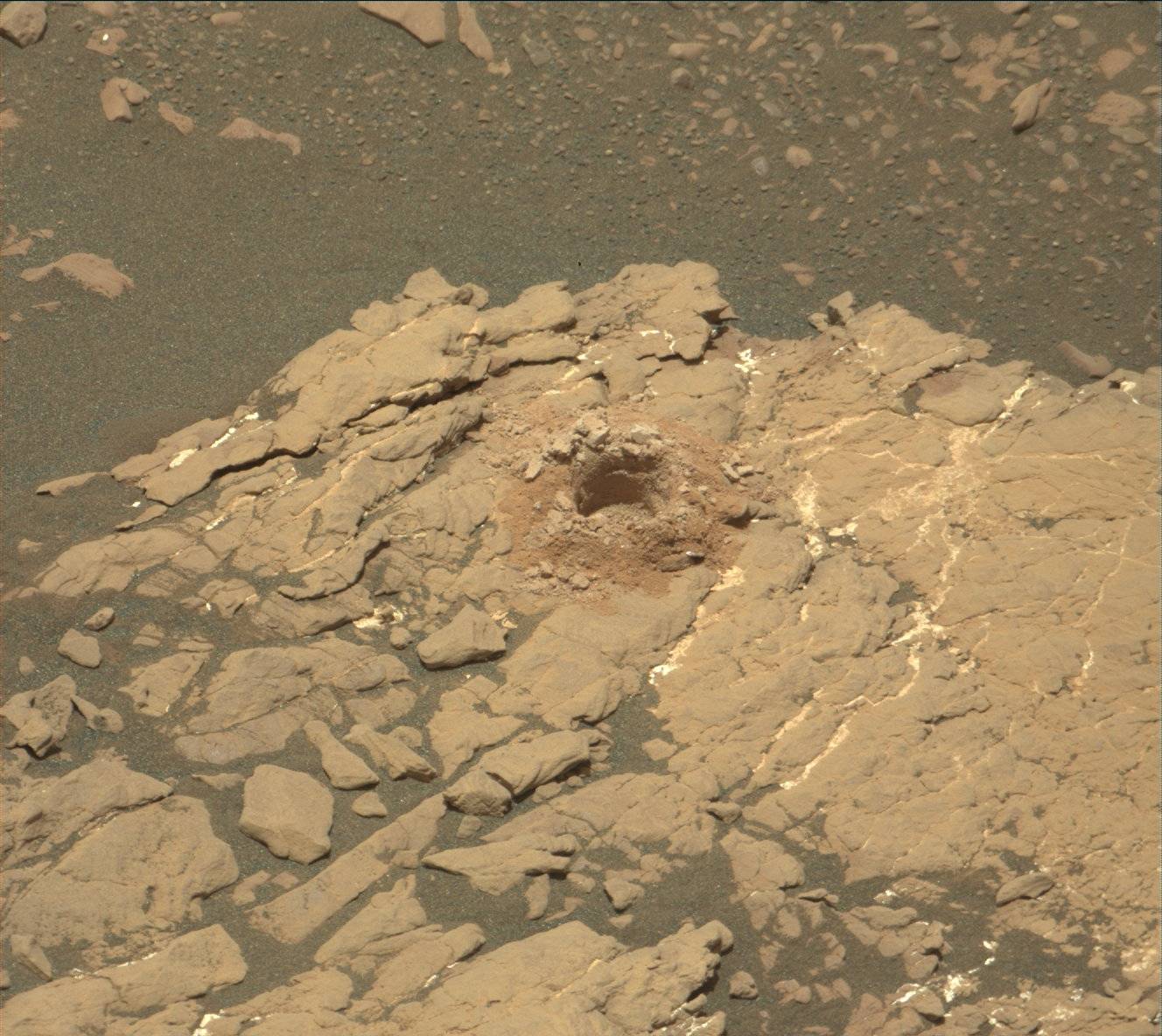
Curiosity is finishing up at "Aberlady" and ready to move on to our next drill target. We are preparing to drill a second hole in the clay bearing unit. Reaching this region, and drilling has been a goal since Curiosity landed over 6 years ago (Sol 2369-2371:This is why we came to Gale.) We were already successful drilling once, and now we will attempt to drill for a second time. Anytime we drill, we take a few sols to prepare. Tosol is considered drill sol 0.
Before we say goodbye to "Aberlady" and move on, we will use MAHLI to image the drill cuttings from "Aberlady." After that the arm will retract and be stowed. To get to our next target, Curiosity needs to drive less than 1 meter to get into position. These short drives are called a "bump." After the bump, we will take Mastcam images, MARDI image, and turn DAN on active mode.Sol 2382 update by Susanne Schwenzer: After the drill is before the drill… (19 Apr 2019)
Some days just give me goose bumps. First, looking at yesterday's plan I realized that we did something really unusual overnight: Wrap up the drill activity on one site and start the drill activities on the next in the same sol. As reported yesterday, we said Good-bye to "Aberlady," and we turned the rover to "Kilmarie," our next drill target. The two targets are just 80 centimetres away from each other.
But that was not the only thing that made the day special. On some days we start planning just before the MRO (Mars Reconnaissance Orbiter) data downlink is due to deliver the data that we need for planning. Today was such a day. Seeing the data arrive, displaying them the moment they show up, and discussing what we see immediately after the data reached us, is one of the most exciting moments of such a planning day. But there wasn't much time to think about emotions, because we were looking at the next step of the drill activity and needed to assess the options on the block we had just successfully bumped to.
Discussions started immediately, and a sol full of activities was planned. The sol plan begins with the preload test on the "Kilmarie" target drill candidate. This is to see if the rock will withstand the pressures during drilling. MAHLI images document the outcome of the test. If successful, drilling will follow. The next activities in the plan include two LIBS ChemCam activities and accompanying Mastcam documentation images on the targets "Udny Green" and "Green Craig." They are both targeting the pebbly materials as we need to understand its composition better, especially if all of the material has the same chemistry, or what the differences might be. The rover is then set to be busy overnight with an APXS on the "Kilmarie" target, getting two slightly offset measurements to characterize the composition of our new drill target candidate.Sol 2383 - 2385 update by Abigail Fraeman: Drill all the rocks! (19 Apr 2019)
Yestersol's drill pre-load test was successful, so today we are go for a drill attempt at "Kilmarie!" The front hazcam image from yesterday's test (shown above) is a helpful visual for understanding how close our new drill location will be to the last drill at "Aberlady." In this image, you can see Curiosity resting the point of the drill on the future Kilmarie drill target along with the old Aberlady drill hole, a little to the left of the arm. It's been a while since we've drilled two locations so close together! Avid readers of this blog will recall we decided to drill again in this area because we saw some irregularities during drilling Aberlady. Specifically, we weren't sure we'd collected enough drill material for both CheMin and SAM analyses at the Aberlady location, so we're hoping we can be more confident in the amount of sample we collect at Kilmarie.
I was staffed in the role of Surface Properties Scientist (SPS) during planning yesterday and today. One of my responsibilities as SPS is to help assess whether the terrain Curiosity is parked on is stable. Curiosity's arm is so big and heavy that moving it causes the rover's center of gravity to shift. If Curiosity isn't firmly parked, moving the arm could inadvertently move the entire ~1 ton rover, which could result in hardware damage. Yesterday, we determined Curiosity had parked on a flat surface and five of the wheels were firmly in contact with the ground. However, the right front wheel appeared to be sitting on a very small rock (~2-3 cm) that was located right in the middle of the wheel. We had a lot of conversations about what the risk of the vehicle slipping was and whether we thought the rock we were sitting on might shift. Using our experience testing similar situations in the Mars Yard at JPL and knowledge of properties of the terrain around the rover, we decided the risk we'd slip was very small, and gave the "OK" to go ahead with arm activities. Images taken before and after the drill pre-load yesterday confirmed we hadn't moved at all and were correct in our assessment.Sols 2386-2387 update by Ken Herkenhoff: A new drill hole! (22 Apr 2019)
The drilling planned for last weekend was successful, so the top priority for Sol 2386 is to drop portions of the Kilmarie sample onto a closed SAM inlet cover and take Mastcam images after each dropoff to characterize the size of each portion. The results of this portioning test will be used to decide how many portions to eventually drop into SAM. After this testing is completed, Mastcam will measure the amount of dust in the atmosphere above MSL by imaging the Sun through neutral-density filters, and Navcam will search for clouds. Then the ChemCam RMI will acquire a "stack" of images of the Aberlady drill hole at various focus settings to find the best focus setting for future LIBS elemental chemistry measurements from our new vantage point. The RMI will also acquire a couple mosaics of the sulfate-rich rocks exposed in the distance southeast of the rover. Mastcam will measure variations in sky brightness to constrain the size of dust grains suspended in the atmosphere before the rover takes a long nap. Late that evening, CheMin will vibrate its inlet sieve and dump the Aberlady sample in preparation for analysis of the Kilmarie drill sample.
On Sol 2387, Mastcam will again measure dust opacity and Navcam will search for dust devils and clouds. ChemCam will then use its laser to measure the elemental chemistry in the wall of the new Kilmarie drill hole and of a nearby pebble named "Quirang" and a bedrock outcrop named "Caledonian Canal." The Right Mastcam will image all of the ChemCam targets before DAN turns on its neutron generator to search for hydrogen up to half a meter below the surface.
It was a quiet day for me and the other MAHLI/MARDI uplink leads, as MAHLI activities are precluded while there is sample in the drill stem. Still, it was interesting to follow the tactical planning today!
Protect Our Shared Future
You help us defend humanity and prevent asteroid impacts. Donate now to become a Planetary Defender!
Donate