
 Explore Worlds
 Find Life
 Defend Earth


Curiosity Update, Sols 2163-2256: Hard Times Atop Vera Rubin Ridge
Written by
Emily Lakdawalla
December 11, 2018
It’s been a challenging few months on the Curiosity mission, but the team’s hard work and persistence has saw them recover from a major computer anomaly and make progress on science goals at Vera Rubin ridge. Curiosity has been exploring the ridge since sol 1809, trying to drill into four distinct rock types. The ridge rocks have proven tough to drill, but the work is almost done. With a third successful drill site at Highfield on sol 2224, they're ready to tackle the last ridge challenge, a drill site in a particularly red-colored rock.
I’ll describe the computer problem first, then give an update on the science operations. But before I do either of those things, just for fun: a video of a herd of dust devils! It’s getting windy in Gale.

And here’s the latest map from Phil Stooke to provide context this blog entry. All of Curiosity’s activities in this update took place in the lower left corner.

The B-side Anomaly
On September 15 (sol 2172), engineers noticed the rover behaving oddly: it was not transmitting any saved science or engineering data, but could transmit engineering data acquired in real time as long as it was communicating with the Deep Space Network or an orbiter. The rover was perfectly healthy, having no issues running any of its vital systems, but had lost access to the part of its memory where it stores data for later retrieval. The data structure of that part of the rover’s memory had become corrupted, and the rover couldn’t access it. This was, clearly, a serious problem for science, but fortunately didn’t threaten the safety of the rover.
Still, the fact that the rover couldn’t store information for later retrieval made it very difficult to troubleshoot the issue. The mission determined that the best course of action was to swap to the backup computer; once they were on the backup, they'd be able to troubleshoot the (formerly) main computer. Curiosity has been operating on its B-side computer for nearly 2000 sols, ever since sol 200, when a serious problem occurred in the A-side computer’s flash memory. It took until sol 772 to recertify the A-side computer for use as a backup to the B-side computer; a software patch now prevents the A-side computer from using half of its flash memory.
Curiosity returned to limited operations by sol 2204, and had resumed science planning with the full team on sol 2216. This is a remarkably fast recovery, given the ridiculous quantity of work the team had to do -- and how carefully they had to do it -- to return the rover to its A-side computer. Meanwhile, unlike with the sol 200 anomaly, the B-side computer is still available as a backup to the A-side one, if anything happens; Curiosity would be safe running on the B-side one, it just wouldn’t be able to do science.
For those of you who enjoy the tricky details of doing a computer swap with a rover on another planet, read on for what I learned from talking with project scientist Ashwin Vasavada. Otherwise, skip to the science operations section of this update. Sysadmins, you’re going to love this.
Troubleshooting a Computer from a Very Long Way Away
Spinning up the A-side computer was harder than just turning it on again. One reason is that the two computers are connected to different sets of critical hardware. In particular, the two computers are hardwired to two completely different sets of engineering cameras -- the Navcams on the rover’s mast and the rear and front Hazcams on the rover’s belly. None of the A-side cameras had seen a photon for more than five Earth years. They had to be turned on and run through their paces, and their images checked against old calibration models.

The rover uses the Navcams and Hazcams for autonomous navigation and for planning arm operations that reach out and touch Mars, so it matters when their point of view shifts slightly. (To be specific, when Curiosity switched from B-side to A-side computers, its Navcam point of view shifted upward by 4.8 centimeters; its front Hazcam point of view shifted to the rover’s right by 8.2 centimeters; and its rear Hazcam view shifted to the rover’s left by 1 meter.)
A long time ago, when the last computer swap happened after the sol 200 anomaly, engineers made the unpleasant discovery that the B-side Navcams experienced a weird temperature-dependent geometry effect in their pointing that made autonomous navigation especially challenging. Now that they had decided to switch back to the A side, they couldn’t be sure the A-side cameras didn’t have the same problem, because it hadn’t experienced a full set of seasons by sol 200, and anyway things might have changed in the intervening 5 years. So they had to do testing of the A-side cameras throughout the temperature swings of a Martian day to make sure they didn’t need to write temperature dependency into the rover’s navigation software for those cameras. To that end, they took 14 sets of images with each pair of cameras on sol 2209 and a further 8 sets in the early morning on sol 2210, finishing with a full Navcam panorama of the deck. Thankfully, the tests showed that the Navcams were performing great and didn’t have any temperature-dependent pointing that would affect navigation.
Next, the engineers had to concern themselves with updating the A-side computer. It was already running an up-to-date version of the operating system, but was missing 2000 sols’ worth of updates to configuration files. Those files include things like all the observation sequences and lookup tables that have been developed for all the different instruments in the last 2000 sols. And because the engineers can’t access the necessary file partition on the B-side computer, they couldn’t simply copy the config files over from one computer to the other. The rover computer also stores hundreds of individual parameters controlling aspects of the hardware. While the A-side computer still had these in memory, its memory hadn't been updated since sol 200. Every one of these had to be checked individually.
Every team had to go through everything they’d ever uploaded to the rover and provide the missing configuration files to the recovery team, which then had to package and upload them to the A-side computer. This was, to put it mildly, not a fast process, and Ashwin had high praise for the team’s work: “As the JPL-based project scientist, I really enjoy watching our scientists from all over the world take on these challenges. And, I also get to witness the brainpower that JPL brings to bear when the rover has a technical issue.” The anomaly response team included not only current rover engineers but also several people who had been involved with rover development who have since moved on to other projects at JPL. (Most of those extra people have now returned to their current projects, and it’s back to current Curiosity engineers continuing to diagnose the B-side computer.)
The engineers know full well that every lost day is a hit to science, so they suggested to the science team that they could return to science as quickly as possible by bringing the simpler capabilities (like environmental monitoring with the REMS, RAD, and DAN instruments) back online first, and slowly ramp up the other capabilities. The engineers got environmental science going again on sol 2204, leaving a 32-sol gap in the environmental record from REMS and RAD. Full science resumed on sol 2216. The team discovered that wind had scrubbed the workspace clean of dust and drill tailings during the intervening weeks, leaving the attempted drill location remarkably clean. I’m impressed by the crispness of the outline here.

Right next to Inverness, the rover took this photo of a fascinating target named Grange. What the heck are those little black nodules? I can’t wait to find out what ChemCam made of this spot. There are similar features in a MAHLI target named Lossiemouth.

The engineers took the rover for a short test drive on sol 2218, resumed using visual odometry (autonomous checking of drive distance travel) on sol 2221 with a good long drive, and bumped to Lake Orcadie on sol 2222. The sol 2221 drive put the total mission odometry above 20 kilometers.
While I’m talking about milestones, the rover passed the longevity of Spirit on sol 2210. Curiosity is now the second-longest-lived rover ever to have explored Mars.
Hard Times on Vera Rubin Ridge
As I’ve explained before, the science team wanted to drill in four types of rock at Vera Rubin Ridge. (If you really want to dig into the science on Vera Rubin ridge rocks, here are some useful Lunar and Planetary Science Conference abstracts, Kristen Bennett et al. and Lauren Edgar et al.) They drilled into Blunts Point rocks just below the ridge, at Duluth, on sol 2057. Their next target was the lower-elevation Pettegrove Point member of Vera Rubin ridge. Following two unsuccessful drill attempts at Voyageurs on sol 2112 and Ailsa Craig on sol 2122, they successfully drilled into Pettegrove Point rocks on sol 2136 at Stoer. The final drill targets were two distinct types of rock in the Jura member, referred to as “red Jura” and “gray Jura.” (The “gray” one has also been referred to as “blue” in the past.)
Gray Jura had been the target at Lake Orcadie a long time ago, on sols 1977 and 1983, but the drilling attempt didn’t work, penetrating at most 10 millimeters. However, both of those attempts had been rotary-only drilling, without percussion. Since Lake Orcadie, the engineers have returned percussion capability to Curiosity’s drill. As I mentioned above, the attempt at Inverness, on sol 2170, wasn’t successful. Based on other observations at Lake Orcadie, the team thought it likely that they might succeed with percussive drilling where they’d failed with rotary-only drilling, so after recovering from the B-side computer anomaly they returned to Lake Orcadie for another attempt nearby.

So it was, with the fourth try at Highfield on sol 2224, they succeeded in drilling gray Jura for the first time. The drill was commanded to a depth of 45 millimeters and actually penetrated to 48, requiring an average percussion level of 3 to 4 out of 6.

They tested delivery to SAM on sol 2225, dropping the gray material on the inlet cover. They delivered to CheMin on sol 2226 and to SAM on sol 2231 (taking another photo of the open inlet cover). On sol 2240, they test-portioned the rest of the sample, taking photos to document how much came out of the drill. I like this sequence because the gray Jura drilled material from the Highfield site shows up so brightly against the shiny red of the red Jura.
They zapped a few shiny meteorite fragments with ChemCam, and took a photo of the drill site with MAHLI. Again, much of the drill fines had blown away, filling the erstwhile hole with sand and leaving a crisp outline in the rock. They drove away on sol 2250.
Only red Jura is left to be drilled. It may be difficult to find a spot soft enough for the drill, however. The rocks in the foreground on sol 2250 don’t look good for drilling to my eye -- the way that the veins have eroded deeply into the rock suggests to me that the red rock between the veins is quite hard. Ashwin told me that they’ll assess red Jura drill sites by brushing and preloading the drill against the rock to see if either tool leaves visible scratches before making a decision whether to drill or to bump to another potential drill site. They successfully used this strategy at Highfield to identify a likely drill site -- let’s wish them luck for red Jura.
Miscellaneous Observations and Future Plans
There’s been plenty of other science and pretty pictures mixed in among the drilling and anomaly recovery. It’s spring in the southern hemisphere of Mars, and that means the wind is picking up. (It’s less windy in Gale in fall and winter, and windier in spring and summer.) Curiosity can’t study wind with its weather instrument anymore -- a component of the anemometer was damaged during landing, and now the sensor doesn’t work at all -- so the team is finding other creative ways to observe changes in wind speed and direction. Curiosity’s cameras have been trained on sand-covered ground patches for image-based change detection. These observations require Curiosity to be parked for a few sols, which makes them perfect for holidays like Thanksgiving.
According to Ashwin, the dust storm no longer has any effect on Curiosity. All the weather indicators like temperature and pressure and atmospheric opacity have returned to their seasonal normals, tracking right along with past years.
After they drill red Jura -- or not -- it’ll finally be time for Curiosity to leave Vera Rubin ridge behind and go on to the next major rock type, the clays in the topographic trough south of the ridge. For a look ahead at the campaign planned for the clays, you can read this LPSC abstract by Kristen Bennett and coworkers.

And now, the concatenated MSL mission blogs covering this time period.
Sols 2163-2164 update by Lucy Thompson: Things that go Bump… (5 September 2018)
In our case, the Curiosity rover! The main focus of our 2-sol (sol - martian day) plan today is to bump (drive ~15 m) the rover into place for an attempt at drilling an interesting grey coloured patch of bedrock, identified from orbit within the Jura member of the Murray formation on the Vera Rubin Ridge, referred to as "Loch Eriboll." We want to figure out how these patches of bedrock differ from the surrounding tan coloured rocks, more typical of what we see from orbit.
We had the potential to do a "touch and go" in the plan, whereby we would unstow the arm and use the APXS and MAHLI instruments to examine the chemistry and texture of a target close-up, before driving away. However, the workspace consists of a lot of broken up, smaller pieces of rock and we already have a lot of compositional and textural information of similar rocks. The ability to use the arm is instead being utilized to acquire MAHLI close-up imaging of the REMS UV sensor. This is requested periodically to check for dust and the general health of the sensor.
We decided to concentrate our efforts on the bump and some remote science observations using instruments situated on the rover's mast. We selected 4 bedrock targets for investigation with ChemCam ("The Law," "Eathie," "The Minch" and "Windy Hills"), to monitor compositional variation, accompanied by Mastcam documentation of those targets. Mastcam mosaics are being acquired of the "Laithach" area where we observe a potential contact between the grey and tan rocks, and the "Loch Eriboll" area, which will include multiple filters to look at the spectral properties of the different rocks. We then bump to our potential drill location followed by imaging of the new workspace and a 20 minute DAN Active measurement.
Post-drive, there are two untargeted ChemCam AEGIS activities to look at bedrock composition, standard REMS and DAN passive, Navcam imaging to monitor the atmosphere/environment, CheMin vibe and dump sample (after X-ray diffraction on the previously drilled "Stoer" material), MARDI (used to document the ground immediately beneath the rover wheels) and SAM Electrical Baseline Test (to periodically monitor SAM's electrical functions).
A busy 2-sol plan to hopefully set us up to drill in the weekend plan!
Sol 2165 - 2167 update by Sean Czarnecki: It always looks grayer on the other side! (10 September 2018)
Curiosity's last plan didn't quite get our intrepid rover close enough to our next potential drill location in the gray bedrock that is visually distinct on this part of Vera Rubin Ridge. This weekend's plan was intended to be "Drill Sol 1," but since it would require at least another short drive to drill, the team decided to choose another target a little further away that will provide a better science return. So the weekend plan now includes a short drive to our new drill target.
Before we drive, ChemCam will measure the chemistry of the targets "Great Bernera," "Great Glen," and "Great Todday;" Mastcam will take images of these same targets including a multispectral observation of Great Todday; and APXS will measure the chemistry of targets "Trollochy," "Burn O Vat," and "Portobello." These observations are intended to document the compositional diversity of the gray and red bedrock at this location by documenting the transition from gray to red.
In addition, the DAN instrument will make a total of 60 minutes of active measurements before the drive. DAN active experiments emit neutrons that interact with the subsurface and then measure the time-of-flight and energy of neutrons that return to the rover. These data allow us to interpret compositional layering and abundances of water bound in minerals in the martian subsurface.
Following our drive, ChemCam has two more sets of chemical measurements on AEGIS targets, APXS will measure the argon abundance in the martian atmosphere, and DAN will take another standard active measurement. Also in the plan are standard DAN passive and environmental monitoring activities with the REMS, RAD, Mastcam, and Navcam instruments.
It's a weekend packed full of science to set up our next drill campaign!
Sols 2168-2169 update by Kristen Bennett: Starting the drill campaign at "Inverness" (11 September 2018)
In the weekend plan Curiosity drove to an area that the team thought would be a good location for the next drill site on Vera Rubin Ridge. The drive was a success, and there is a block named "Inverness" in the center of the workspace that was selected to be the next drill target.
The 2-sol plan focuses on characterizing Inverness in preparation for the drill campaign. This includes removing dust from the surface of the rock with the DRT, as well as taking MAHLI images, APXS measurements, a ChemCam LIBS observation, and a Mastcam multispectral observation of Inverness.
In addition to all of the measurements of Inverness, Curiosity will begin taking change detection images. The rover will be sitting in one spot for some time during the drill campaign, so this is a good opportunity to see if any of the sand around Curiosity is being moved around by the wind. In the current plan this includes a MARDI twilight image and Mastcam images of "Sandend" and "Skene."
But wait! There's more! This plan also includes a Mastcam image of the target "Stoneyburn," a Navcam dust devil survey, and MAHLI night time images of the CheMin inlet.
This full 2-sol plan will set Curiosity up to start drilling into the next target on Vera Rubin Ridge later this week. Just another day planning to put holes in rocks on Mars!
Sols 2170-2171 update by Catherine O’Connell: Go for Drill at Inverness! (13 September 2018)
In our previous plan, we assessed the suitability of the Inverness target for drilling. We used APXS to determine if it fell within the required geochemical parameters, first brushing to remove excess dust and then using curium to irradiate the target and acquire whole-rock geochemical data. Curiosity also did a series of "stress tests" to test the integrity of the target, and check whether it would be strong enough to withstand our percussive drill technique without shattering. At the beginning of today's planning, we received data which confirmed that Inverness had passed our tests. Drilling begins tomorrow (sol 2170) on what will hopefully be our 18thsuccessful drill hole in Gale crater!
If successful, the resulting sample will be processed internally by CheMin (to assess mineralogical composition) and possibly SAM (to look for chemical signatures). The remaining collected drill sample will be dumped at a later date, so MAHLI will take imagery of potential dump locations on sol 2170 to help with later analysis. A pile of "tailings" will also be generated around the drill hole by the drilling activity. These tailings will be analyzed by ChemCam, APXS and MAHLI in the coming weeks - Mastcam will acquire images of the drill-hole and multispectral images on the tailings on sol 2171.
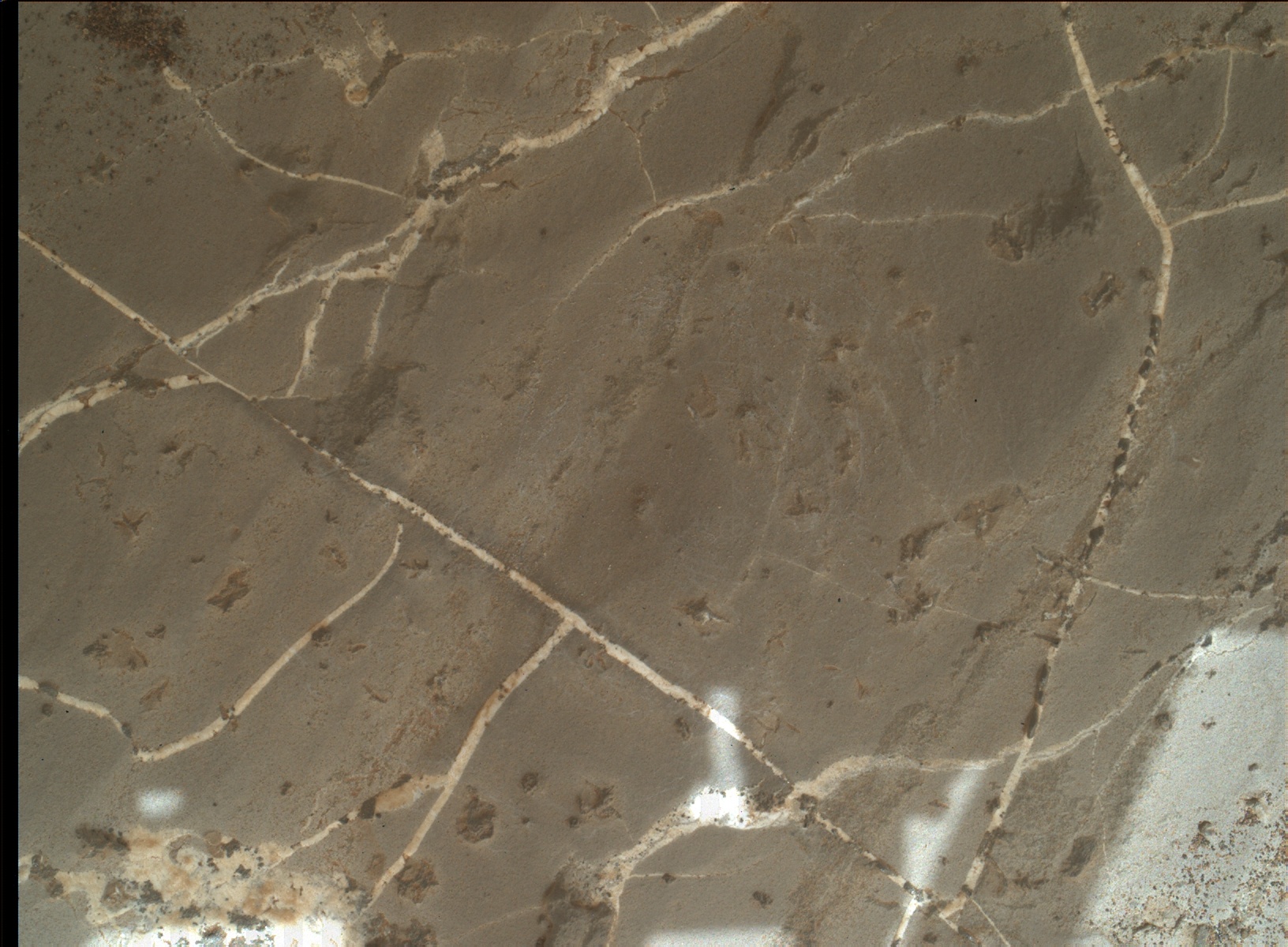
Today's 2-sol plan included three ChemCam LIBS targets on sol 2171 on an interesting network of veins and diagenetic features, revealed in the MAHLI image of the brushed Inverness target (shown above). "Pentland" (to the left of the image) consists of large veins. "Black Isle" is a grey, raised, nodular feature, in the right of the image, whilst "Grange" is a white patch, just below the brushed area. These targets will also help us look for variations across the Inverness block. All three targets will be imaged using Mastcam.
Although the plan is packed with drill related activities, we still fit in environmental monitoring activities, such as the Mastcam tau (to determine the amount of dust in the atmospheric column), standard DAN and REMS activities, and continuing Mastcam change detection of the targets Sandend and Skene (looking for evidence of grain movement, wind directions and strength).
Although drill campaigns can take up to two weeks to complete, we are starting to look ahead, thinking of our next potential drill site. Mastcam multispectral images taken on sol 2171 will be used to help us decide which direction to head in next!
Sols 2172-2174 update by Vivian Sun: Who'd Have Thought That Ridge Rocks Could Be So Hard (17 September 2018)
Last night we learned that our drill attempt on "Inverness" was not successful, reaching only 4 mm into the rock. Today's tactical team bounced back from this news and quickly assembled a plan to move on. This proved to be a busy day for the whole team, including me as the Geology Keeper of the Plan!
Our first order of business was discussing where to drive next. The grey Jura member is a top priority for sampling and understanding the geologic history of the Vera Rubin Ridge, so we felt it was imperative to try again. We ultimately decided to return to the "Lake Orcadie" region, where we previously attempted to drill on Sol 1977. In the past attempt, we were able to reach 10 mm depth using rotary only, so we are hopeful that this next attempt will reach sampling depths with the new percussion-enhanced drill capabilities.
Before driving off, we wrapped up at the Inverness site with APXS and ChemCam spectral measurements to characterize the composition of the drill tailings and the mini drill hole. We additionally targeted "Clune," a grey Jura bedrock, with ChemCam to continue our documentation of compositional heterogeneities in bedrock. Some science team members also identified two possible meteorite targets, so we obtained a ChemCam measurement of "Stoneyburn" and a Mastcam multispectral observation of "Rockend" to see if they have meteorite compositions. On Sol 2173, we planned a long 65 m drive to get Curiosity close to our next drill site in the Lake Orcadie region. We ended the plan on Sol 2174 with ChemCam calibration and sky observations, as well as our usual post-drive MARDI twilight image to document the terrain beneath the rover. If all goes well, we should be at our next drill site in no time!
Sols 2175-2176 update by Ashwin Vasavada: Tell Us More, We Want to Help! (19 September 2018)
Over the past few days, engineers here at JPL have been working to address an issue on Curiosity that is preventing it from sending much of the science and engineering data stored in its memory. The rover remains in its normal mode and is otherwise healthy and responsive.
The issue first appeared Saturday night while Curiosity was running through the weekend plan. Besides transmitting data recorded in its memory, the rover can transmit "real-time" data when it links to a relay orbiter or Deep Space Network antenna. These real-time data are transmitting normally, and include various details about the rover's status. Engineers are expanding the details the rover transmits in these real-time data to better diagnose the issue. Because the amount of data coming down is limited, it might take some time for the engineering team to diagnose the problem.
On Monday and Tuesday, engineers discussed which real-time details would be the most useful to have. They also commanded the rover to turn off science instruments that were still on, since their data are not being stored. They're also preparing to use the rover's backup computer in case they need to use it to diagnose the primary computer. That backup computer was the rover's primary one until Sol 200, when it experienced both a hardware failure and software issue that have since been addressed.
While the engineers work to understand the problem, Curiosity's science team is using the time to pore over data gathered on Vera Rubin Ridge and come up with the best location for another drilling attempt. We're looking at any clues that tell us the rocks are weaker and better for drilling. As the JPL-based project scientist, I really enjoy watching our scientists from all over the world take on these challenges. And, I also get to witness the brainpower that JPL brings to bear when the rover has a technical issue. We're rooting for the engineering team 100%!
This blog may be less frequent until science operations resume.
Science story by Susanne Schwenzer: Geology - It's like Investigating a Crime Scene (5 October 2018)
Sometimes planetary geology is like forensics. We are presented with a crime scene: Something broke down the original igneous rock, and made all those clays, veins and hematite nodules. We know this something was a fluid, but in order to find out exactly what has happened, we need to examine all the evidence we have. That often starts with investigating the images, and in great detail. That's when we look at Mastcam images for the geologic context, then RMI and/or MAHLI for the close-up details. But what about the chemistry?
We are a small team here in the UK, specializing in what is called "thermochemical modelling." Thermochemical modelling uses mathematical equations that are based on known reactions of minerals with water. The models combine many thousands of such reactions into equations, which can be solved iteratively to arrive at a reaction path for a known rock composition. And once we determine what reacted and how, we can also infer which chemical elements remained in the water because they were not included in the reaction products. In other words, we can find out how the chemical elements are distributed between the fluid and the newly forming minerals. Some of our French and American colleagues use this method too, and we always have great discussions to advance our work. We take all the data that we have, images and chemistry from ChemCam and APXS, and where available also mineralogy from CheMin. That's the evidence at our crime scene. But who broke the rock and left all those clays and white veins?
We know it is "the fluid," and the modelling allows us to find out what temperature and composition this fluid might have had. For example, we have looked at the veins Curiosity found very early in the mission - at Yellowknife Bay. They were very pure calcium-sulfate, especially compared to what Curiosity measured later at Garden City and now at Vera Rubin Ridge. The purity of the calcium-sulfate at Yellowknife Bay gave us a clue: If we model a typical Yellowknife Bay rock with all chemical elements in the proportions available in this rock to react with water, then we will get veins that have more than just calcium-sulfate. We would therefore expect veins that have other minerals such as iron oxides and quartz. But the veins at Yellowknife Bay did not have any of those additional minerals. Therefore, we concluded that they must have come from water selectively dissolving a pre-existing mixed-mineralogy layer. The dissolution of this pre-existing layer would have left the less soluble minerals - quartz, iron oxides - behind while transporting the calcium and sulfate. This would have allowed the formation of a very pure calcium-sulfate, which is what was observed! But how does that help us at Vera Rubin Ridge?
The rover is currently exploring a very complex area, which has clearly seen the interaction of rocks with fluids. There are veins much more complex than the ones at Yellowknife Bay, and in addition there are iron nodules, crystal moulds and colour changes. We, the modellers, are working hard to understand how the fluid changed to produce all this new evidence… more later, as investigators rarely talk about ongoing investigations, right?
Science story by Abigail Fraeman: Crystal Balls May Show the Future, but Gypsum Crystals Tell Us About the Past (8 October 2018)
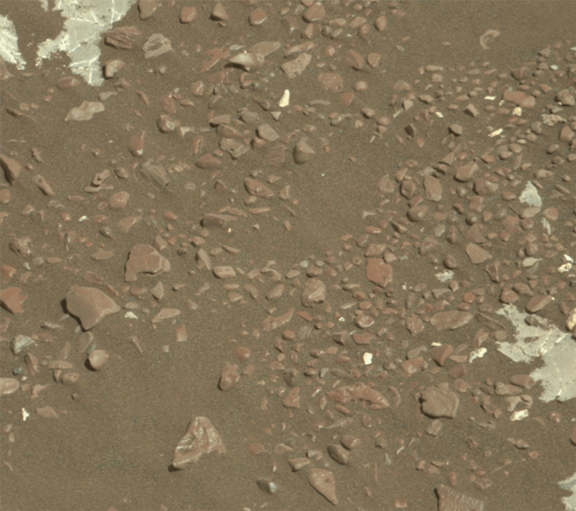
As Curiosity continues to mend, I've been looking forward to our next drill sample of gray rock. Some interesting features we've seen on Vera Rubin Ridge are small "swallowtail crystals" often associated with the boundary between gray and red rocks on the ridge top. In thinking about these features, I wanted to take the opportunity to reflect on past results from when Curiosity was just beginning to explore Mt. Sharp at the Pahrump Hills region. Readers of this blog may remember that back on sol 809, after we brushed away the dust on target "Mojave," the team was surprised and excited to discover hundreds of millimeter-sized, rice-shaped crystals on its face. These crystals are geologic clues to what happened in the past. What were these unique features made of? How and when did they form?
SWALLOWTAIL CRYSTALS CLOSE TO DRILL ATTEMPT AT INVERNESS
This image was taken by ChemCam: Remote Micro-Imager (CHEMCAM_RMI) onboard NASA's Mars rover Curiosity on Sol 2163 (2018-09-06 12:10:38 UTC). Image Credit: NASA/JPL-Caltech/LANLCuriosity scientist Linda Kah and colleagues address these questions in a new paper available in the journal Terra Nova titled "Syndepositional precipitation of calcium sulfate in Gale Crater, Mars." For this study, Kah and colleagues carefully studied the sizes, shapes, and orientations of the unusual crystals at Mojave and several nearby targets. They integrated these findings with the geologic setting, chemistry, and mineralogy of the Pahrump Hills area to infer the presence of shallow, salty, and sometimes ephemeral waters during this period in Gale's history.
Kah and co-authors explain that the crystal shapes are distinctive of gypsum salts that precipitate in lake, playa, and near-shore ocean environments. Interestingly, Curiosity did not detect any large differences in the composition of rocks containing crystals versus nearby, non-crystal-containing rocks. This result suggests the calcium sulfate that originally formed the crystals had either been dissolved at a later time and/or that the crystals had incorporated a lot of the original rocks around within them when they formed.
The shapes, sizes, and orientation of crystals give clues to how they grow. Kah and authors showed the crystals at Pahrump were randomly oriented and occurred between and within cemented layers. Combined with the crystals' elongated shapes, this suggests that they grew at the interface between loose, water-logged sediment and either shallow water or air. Interestingly, small amounts of organic (carbon-bearing) material can cause crystals to have shapes similar to those observed at Mojave, which is consistent with Curiosity findings of organic material in the Mojave drill sample.
The swallowtail crystals on Vera Rubin Ridge are also known shapes of gypsum crystals. Why are these crystals so different in form from what we saw back at Mojave? What does this all tell us about ancient environments at Gale Crater?
Related Mojave news story: Crystal-Rich Rock 'Mojave' is Next Mars Drill Target ››
Article: Syndepositional precipitation of calcium sulfate in Gale Crater, Mars ››Sol 2204 update by Sarah Lamm: Curiosity science is baaaack! (19 October 2018)
Contrary to the "frightening" title, the Curiosity team is excited that science operations are starting to resume! The real fright was when Curiosity had an anomaly on Sol 2172 which affected its memory. Since then, the engineering team has continued to diagnose the anomaly and plan the recovery, including taking the first images with the A-side engineering cameras that haven't been used since 2013! Thanks to our hard-working engineers, Curiosity is ready for limited science operations while the anomaly work continues.
Curiosity has been at the (sadly) unsuccessful "Inverness" drill site since the anomaly. Curiosity is still exploring the gray Jura member on Vera Rubin Ridge. The uplink plan for Sol 2204 includes the use of RAD, REMS, and DAN (active and passive).
RAD detects high-energy radiation on the Martian surface. RAD's data will help shape future human mission to Mars by letting us know how much shielding from radiation future Mars astronauts will need to protect them. REMS (Rover Environmental Monitoring Station) is Curiosity's weather station. REMS can measure pressure, humidity, ultraviolet radiation, and temperature. DAN (Dynamic Albedo of Neutrons) detects neutrons that be used to measure the amount of hydrogen and other elements in the subsurface.
Science story by Catherine O’Connell-Cooper: Recap of the Bagnold Dune Investigation (22 October 2018)
As Curiosity continues on her journey up Mount Sharp (the mound in the centre of Gale crater), rocks we encounter contain evidence for changing environmental conditions. The fine-grained mudstones of the Murray formation show us that lakes were present in the past, whilst the sandstones of the Stimson formation are evidence for ancient dune fields.
During 2015-2017, we crossed the Bagnold dune field, a 35-km long by 1-2 km wide dune field that wraps around the northwest side of Mount Sharp. This was the first time that scientists have explored an active dune system on another planet. In the Martian fall/winter, we investigated two barchan dunes. Barchan dunes are crescent shaped and are formed by winds blowing in one direction, and when sediment supply is limited. Later on, during the Martian summer, we examined a linear dune. Linear dunes are formed by winds blowing in two directions, with more abundant sediment supply, and can be very long (on Earth, they can reach 160 miles in length e.g., Namib Sand Sea, Namibia).
Curiosity lived up to her official name "Mars Science Laboratory" for both parts of the campaign, utilizing almost every scientific instrument on board, plus the engineering cameras (Navcam and Hazcam) to collect observations and measurements. In a series of papers recently released, we present these results, looking at all aspects of the Bagnold dunes.
As we traversed the dune field and at each stop, we observed the physical properties of the sand dunes, such as grain size, rates of grain motion, and the overall bedform morphologies, using MAHLI, ChemCam, MARDI, Mastcam, Navcam, and REMS. We observed differences in wind activity levels, with lower wind and less movement of sand during the fall/winter than during the summer. Dust content (indicated by sulphur, chlorine and zinc levels, as measured by APXS; higher concentrations mean higher dust content) indicates that observed activity levels were higher in the linear dunes which were investigated during the summer (higher winds, less dust settling) and lower in the barchan dunes, which were investigated during the fall/winter.
We determined chemical composition, mineralogy and volatile content of sands using APXS, ChemCam, CheMin, DAN and SAM. My role as a member of the APXS operations team involved evaluating the composition of samples analyzed, comparing between the barchan and linear dunes, as well as sands previously analyzed by the Opportunity rover (at Meridiani Planum) and Spirit (at Gusev Crater). The basaltic Bagnold sands show subtle variations in mineralogy and chemistry, both between the barchan and linear dunes, but also depending on location within a dune. For example, ripple crests were often more coarse-grained and enriched in magnesium and nickel, whilst off-crest sands within the linear dunes were enriched in chromium. These variations may reflect sorting processes, or minor enrichments from local bedrock sources.
Our journey through the Bagnold Dunes has helped advanced our understanding of how winds shape modern Martian landscapes, and the properties of windblown materials, in the form of both the active Bagnold dunes and in ancient Martian dunes now preserved as rock in units such as the Stimson formation at Gale crater.
AGU Journals:
- Investigations of the Bagnold Dune Field, Gale crater ›
- Curiosity at the Bagnold Dunes, Gale Crater: Advances in Martian Eolian Processes ›Sols 2211-2212 update by Ashley W. Stroupe: Getting Back into the Science Swing of Things! (24 October 2018)
While we are working toward understanding and recovering from the anomaly, Curiosity is slowly ramping back up into normal science operations.
Earlier this week, we got our environmental instruments DAN, RAD, and REMS back online and we exercised the arm for the first time since the anomaly, retracting it from the surface and moving it above the deck. Today we are doing some environmental and atmospheric observations with REMS, RAD, and DAN. We're also using our Engineering cameras to do atmospheric science observations and some sky imaging to help in camera calibration. Mastcam is also being used for the first time to take several atmospheric tau measurements, as well as looking out at our workspace and the targets we were investigating. We're specifically doing change detection to see if the drill fines have moved around with the wind and if there is dust moving around on the targets and on the rover deck. We're looking forward to getting the rest of our instruments, the arm, and mobility all back to nominal operations soon.
An important milestone to note - on sol 2211 Curiosity will surpass the lifespan of the Spirit rover (we last heard from her on sol 2210) and become the second-longest lived rover on Mars, second to Opportunity!
Sols 2213-2215 update by Lauren Edgar: Eyes on the sky (26 October 2018)
The focus of today's three-sol plan is environmental monitoring. I'll be on duty as SOWG Chair on Monday, so I dialed in today to get up to speed. The first sol kicks off with Mastcam tau, Navcam line of sight, and Navcam dust devil observations, to monitor the dust content in the atmosphere and search for dust devils. Then CheMin will return the remaining raw data frames from the "Stoer" analysis from early September. In the afternoon, Curiosity will acquire a Mastcam sky survey, Navcam zenith movie, and Navcam suprahorizon movie, which will provide additional atmospheric monitoring data. Similar environmental observations will be acquired early the next morning, with an additional Mastcam crater rim extinction observation. The second sol also includes a redo of the pre-anomaly post-drive imaging, to look for changes and provide a terrain mesh prior to resuming full arm and mobility activities. And the third sol includes a final suite of Mastcam tau, Navcam dust devil and Navcam suprahorizon movies, in addition to the standard REMS and DAN passive observations throughout the plan.
But while the environmental theme group has their eyes on the sky, I've got mine on the ground, including the above Navcam view, looking south over the back of the rover, and the new terrain that we are tantalizingly close to reaching. Looking forward to resuming full science operations soon!
Sol 2216 update by Melissa Rice: A Windswept Workspace (29 October 2018)
Today was the first day of planning with the full science team since Curiosity had an anomaly on sol 2172. It has been a over a month since we last looked at the "workspace," the region in front of the rover that the arm can reach, and there were some surprises in store for us! Before the anomaly, the rock was covered with gray-colored tailings from our failed attempt to drill the "Inverness" target, as seen in the Mastcam image from sol 2170. In the new image above, however, those tailings are now gone - and so is a lot of the dark brown soil and reddish dust. So while Curiosity has been sitting still, the winds have been moving, sweeping the workspace clean.
Later this week we plan to take advantage of this freshly-scrubbed surface by taking close-up MAHLI images of fine details in the rock, including the light-toned veins crisscrossing the outcrop that are peppered with interesting dark inclusions. Today we're easing back into science operations, taking MAHLI images with the cover open and closed to inspect how much dust is on the cover, a MAHLI image of the REMS UV sensor, a ChemCam observation of the vein target "Grange," and some Mastcam images of the nearby ripple field "Sandend" to look for more changes due to the wind.
In my role as a Long-Term Planner, I've got my eye on the road ahead, and I'm excited for Curiosity to drive to a new spot where we can successfully drill into the gray rock. Soon the wind won't be the only thing moving around here!
Sol 2217 update by Lucy Thompson: A BOO-tiful Halloween on Mars - Curiosity's Return to Contact Science (1 November 2018)
Mastcam left image showing the Inverness and Grange targets in the workspace.
Today was an exciting day for me as a member of the APXS team and filling the role of payload uplink lead, as Sol 2217 marked a return to contact science activities after our anomaly on Sol 2172. When the anomaly occurred, the APXS was poised to measure the composition of the freshly exposed "Inverness" bedrock surface (after an unsuccessful drill attempt on Sol 2170) to compare with the previously brushed surface and other fresh rock surfaces examined by APXS on the Vera Rubin Ridge. The plan today is to recover this measurement, with accompanying MAHLI imaging, as well as to get chemical and textural data (with APXS and MAHLI) on another interesting target in the workspace, "Grange." "Grange" appears to be an area of bright calcium sulfate (commonly observed as veins cross-cutting bedrock encountered throughout the mission), but with small, dark inclusions that might have an interesting composition.
We also planned ChemCam on a bedrock target "Clune" with accompanying Mastcam imaging, as well as Mastcam imaging of an interesting area of rougher textured rock "Ayr" and multispectral Mastcam observations of the "Inverness" area. The plan was rounded out with some environmental monitoring activities including DAN passive and REMS.
I am looking forward to getting the data down from these observations and comparing the chemistry and textures of these rocks with other rock targets encountered on the Vera Rubin Ridge. The chemistry and textures can provide clues to the conditions the sediments were deposited in as well as subsequent events such as diagenesis (as the sediment is buried, compacted and cemented and turned into a rock), and later alteration.
Looking ahead, Curiosity is hoping to soon drive away from this site towards an area, "Lake Orcadie," where we will attempt another drill into one of these interesting bright grey areas identified from orbit on the Vera Rubin Ridge.
Sol 2218 update by Sarah Lamm: No Candy, Just Science for Curiosity (1 November 2018)
Curiosity had a good Halloween because it had resumed contact science. Today, Curiosity will have a targeted science block, drive, and then have an untargeted science block. MAHLI will take images of the "Lossiemouth" target before the drive. ChemCam has two planned targets before the drive: "Milton Ness" and "Grange 2218." Milton Ness is a target to capture more of the vein material and some bedrock, too. We are taking more measurements of Grange so we have more information on the dark inclusions. There is also scheduled Mastcam imagery for each ChemCam target.
After these science activities, we will be headed toward an area in the grey Jura member called "Lake Orcadie." This would be the first time that Curiosity has driven in six weeks. This will only be a test drive to ensure the software and mechanics are working properly. Curiosity was at Lake Orcadie before, back on sol 1977. We had tried to drill at Lake Orcadie before, using our new drilling method, but it was not successful. Then we planned to drive back to Lake Orcadie on sol 2173, but there was an anomaly on sol 2172.
After the drive we have DAN (active), Mastcam imagery of the new location, and one more ChemCam target called "Aegis Post 2218." AEGIS is artificial intelligence software that we use after a drive. It can use Curiosity’s cameras to identify rocks, and then AEGIS uses ChemCam’s laser to shoot the rocks. This has increased the amount of data we can get from Gale Crater.
My operations role today was ChemCam science downlink lead. I got to process the most recent ChemCam data that had not been analyzed yet. I collect images, locations, and chemistry data and compile the data into preliminary reports. This role helps the uplink team decide if they want to retarget any rock or choose new targets.
Sols 2219-2221 update by Kristen Bennett: Curiosity goes bump! (2 November 2018)
Yesterday Curiosity drove for the first time since sol 2166! Our intrepid explorer is truly back at it after a few weeks off due to the anomaly. The short drive (also called a bump) placed us in a workspace a few meters away from our previous location where we had attempted to drill (see image above that shows a MAHLI observation of the shallow drill hole).
In this weekend's three-sol plan there will be several diagnostic activities that will help us to understand the anomaly. In addition to the diagnostics, the weekend plan includes ChemCam and Mastcam observations of "Dryden" and "Kirkness," which are bedrock targets, and of "Housay," which is a vein within the bedrock. Also included is a Mastcam observation of "Eynhallow" to document laminations within the bedrock, a MARDI image, and a Navcam dust devil survey.
There are ChemCam RMI Zenith Sky Flats scheduled on the first sol. In this activity ChemCam will take images looking up at the sky. This activity needs to happen near sunset because ChemCam should not look directly at the sun. These sky flats help us determine whether there is any dust contamination on ChemCam's optical window, which is important right now because Mars just experienced a global dust event.
On the second sol, APXS and MAHLI will be used to investigate two targets: "Calgary" and "Findon." Calgary is typical gray bedrock, and this target will be brushed with the DRT prior to the MAHLI and APXS measurements.
On the third sol Curiosity will drive towards Lake Orcadie, and next week we plan to start our drill campaign in the gray colored rocks at that location!
Sol 2222 update by Catherine O’Connell-Cooper: Déjà vu - Return to Lake Orcadie! (6 November 2018)
Our attempts to drill grey rock on the "Vera Rubin Ridge" (VRR) continue. We are returning to an area known as "Lake Orcadie," the site of two previous drill attempts (Lake Orcadie and Lake Orcadie 2), which did not penetrate far enough into the bedrock to generate sufficient sample. However, the MSL team feels that the chances of drilling here have improved. Over the past 240 sols, the engineers have further refined the drill technique (here), leading to two successful drilling campaigns (Duluth and Stoer). Additionally, images collected during our previous visit here have helped us to identify three potential drill targets. Criteria such as scratches left in the bedrock by the Dust Removal Tool (DRT) will be used to see if these targets are softer, and therefore more drillable, than our previous choices.
Today's plan focuses on getting the rover to the right location. This involves a short 20 meter drive, to position us so that we are in arm's reach of our target. Science Operations revolve around imaging the drill area, filling in any gaps in our characterization of these potential targets, in order to increase the chance of picking the best one. We also want to make sure that any drill fines generated during our previous attempts here have blown away, so that instruments such as MAHLI can operate safely.
Other activities included standard environmental monitoring activities, e.g., dust devil movies, and a CCAM observation on a piece of rock ("Flotta") which might represent red Jura bedrock (rather than the grey bedrock we are hoping to drill).
If our bump goes as planned, we will complete our final confirmation analyses on the bedrock this week, and begin drilling before the weekend.
Sol 2223 update by Lauren Edgar: Optimism for "Highfield" (7 November 2018)
On Sol 2222, Curiosity drove ~10 m towards the "Lake Orcadie" location, in the hopes that we would be able to drill the gray Jura member here. Today's plan is focused on characterizing the target "Highfield," the bright patch of outcrop shown in the middle of the above Navcam image. I was the SOWG Chair today, and it was a pretty straightforward planning day because most of the activities were pre-planned as part of our standard drill site characterization. First APXS will carry out a short integration on the intended drill target, followed by two MAHLI images. Then we'll use the DRT to brush the target, followed by Mastcam imaging and a full suite of MAHLI images. Then we'll do a drill pre-load test, which means that we'll put weight on the drill bit to make sure the surface can support it, and if it makes marks on the surface this might give us an indication of how hard or soft the surface is. Overnight, we'll acquire a longer APXS integration on "Highfield." We were pretty tight on both power and data volume today so it was a bit of a challenge to prioritize everything, but we're optimistic that this will be our chance to sample the gray Jura member. I'll be on duty again tomorrow, so I'm eagerly awaiting our downlink and hoping that we'll be "go" for a full drill hole here!
Sol 2224 update by Mark Salvatore: Go for Drilling at Highfield! (8 November 2018)
Today was a good day on Mars. The science and engineering teams are making preparations to drill a patch of grey bedrock named "Highfield", which will be our latest attempt to characterize this unique rock unit on Vera Rubin Ridge. Our last attempt to drill into this geologic member of the VRR (nearly 50 sols ago!) was unsuccessful at the drill target "Inverness." This target proved to be extremely resistant and hard, making it difficult for the drill to penetrate deep into the surface and accumulate sample material. So, the science team engaged in quite a bit of discussion about whether the Highfield target is expected to be as hard as or softer than the Inverness target. The team decided that it was worth trying to drill at this location and that the rock has the potential to be softer and more "drillable" than the Inverness target given the data currently in hand. For example, we don't see any fluting of the rock surface as a result of wind erosion, which may indicate that the entire rock erodes relatively quickly. In addition, we see scratches in the rock surface left behind by the rover's Dust Removal Tool (DRT) and other pre-drilling activities, suggesting that the rock is relatively soft.
Today I served as Geology/Mineralogy Science Theme Lead, which meant that I led the discussions between surface scientists and helped to plan the overall approach towards characterizing this region. We were all excited to see the results of yesterday's analyses and surface preparations, and to make the decision to go ahead and try drilling at this location. We'll see if Mars decides to cooperate during tomorrow's planning!
Sol 2225 update by Claire Newman: Science Galore at the Eighteenth Hole (9 November 2018)
Tosol we received confirmation that Curiosity's drill yestersol was successful, as shown in this Navcam image of the "Highfield" target - our eighteenth drill hole in the martian surface!
Not quite a 'hole in one,' as we tried to sample the same gray Jura rock type about 50 sols ago, but we finally have a sample of our highest value target on Vera Rubin Ridge. Rather than retreat to the club house for a well-earned celebration, however, Curiosity and the team stayed busy in Sol 2225, doing Mastcam and ChemCam imaging of the new drill hole and tailings. This was in preparation for the weekend plan, in which there'll be further imaging and ChemCam LIBS on the drill hole, and samples will be dropped off to CheMin for further analysis.
In addition, there's a packed program of environmental science over the next few sols, now that we're back to full science operations. The global dust storm may have decayed, but we're still interested in seeing whether the post-storm atmosphere differs compared to the same season in previous Mars years when no big storm occurred. Also, we're still in the middle of southern summer, which means lots of 'dust devils' (dust-filled convective vortices) and more dust than usual in the atmosphere. So in addition to our regular meteorological (REMS), radiation (RAD), and sub-surface (DAN) monitoring, we added atmospheric opacity measurements and a 360° dust devil survey into tosol's plan. Over the weekend, alongside the drill sample analysis, there will be a bumper crop of atmospheric activities. These include characterizing the amount and size distribution of dust and water ice aerosols at different times of sol, in and above the crater, by means of a Mastcam 'sky survey' and opacity measurements, a ChemCam 'passive sky' activity, and Navcam cloud movies. We'll also take a dust devil movie as well as two more dust devil surveys.
And finally, over the next few sols we'll be watching those drill tailings to see how quickly the martian wind moves them away and in what direction. We'll also be taking 'change detection' images of below the rover with MARDI, and of nearby grains and ripples with Mastcam, again to see what the wind is doing at this time of year in our current location on the slope of Aeolis Mons.
Sols 2226-2228 update by Samantha Gwizd: We came, we science'd, we... still have a lot to do! (10 November 2018)
As we enter this weekend thinking about football, raking leaves, and if you're like me, sleeping a bit more, Curiosity will be gearing up for three sols of hard work! The science team will continue to characterize the drilled "Highfield" workspace by using ChemCam LIBS to examine the chemistry of the drill hole, seen in the above RMI image. This observation will supplement the mineralogical data to be obtained from CheMin soon!
After the drill hole measurements, ChemCam will remain occupied with LIBS planned on targets "Rosebrae" (grey bedrock) and "Cullen" (an interesting combination of bedrock and mottled veins). The weekend science plan also includes a series of Mastcam change detection images to characterize wind-driven grain movement on sand targets "Sand Loch" and "Windyedge."
In addition to the geological observations, the environmental science theme group has included a ChemCam passive sky activity, a Mastcam sky survey, a Navcam dust devil survey, Navcam cloud movies, and Mastcam full tau measurements in the weekend plan.
It's a busy weekend for Curiosity and the science planners. The team is certainly taking advantage of the interesting workspace to squeeze as much science out of it as possible!
Sols 2229-2230 update by Rachel Kronyak: Preparing for more SAMple! (12 November 2018)
Following a successful weekend of science activities at the "Highfield" drill site, today we're planning Sols 2229-2230. We're eagerly awaiting data from CheMin, which will tell us all about the mineralogy of our newest drill hole sample. We're equally as eager to get a Highfield drill sample to the SAM instrument for analysis. To prepare for SAM, on Sol 2229 we'll perform a preconditioning activity to get the instrument ready to receive and analyze sample. Although SAM is located inside the belly of Curiosity, we can see the instrument's inlet covers in the image above, which was taken by Mastcam late last week.
While the SAM preconditioning activity takes up the bulk of Sol 2229's power, we were still able to plan about four hours' worth of science activities! Today was my first Mastcam PUL shift since the anomaly, so I was very excited to see so many fantastic observations make it into today's two-sol plan.
We'll kick off Sol 2229 with a hefty 2 hour-long science block. In it, we'll analyze 4 targets with ChemCam: one down the inside of the Highfield drill hole, another along the drill tailings at the surface, a third on a nearby vein called "Fraser Castle," and a fourth on bedrock target "Flanders Moss." After that, we'll take Mastcam images of each ChemCam target to confirm where the laser shots hit. We'll also image targets "Sand Loch" and "Windyedge" with Mastcam. This pair of images is important for change detection purposes, which we frequently perform when the rover is sitting in the same location for more than a few sols. For change detection, we take the same 2 images around the same time of day to help quantify how the martian wind is changing the landscape around us.
Finally, for Mastcam, we'll take a few multispectral images - these images are taken using multiple camera filters. Experts on the science team use these images to help us interpret the composition of the local bedrock and surrounding areas. We'll take multispectral images of two targets to the side of the rover, "Loch Ba" and "Slate Islands." To wrap up the science block, we'll take some images with Navcam to look for dust devils. Later in the evening, we'll perform our SAM preconditioning activity before going to sleep.
Curiosity will wake up on Sol 2230 for another loaded science block! This time, we'll use ChemCam to perform a passive calibration activity, followed by another Navcam dust devil suite and repeat Mastcam change detection images. We'll then use Mastcam to make additional atmospheric observations in the form of tau and crater rim extinction measurements. Later on in the late afternoon, we'll take a final pair of Mastcam change detection images and perform a sunset tau measurement.
It was a busy day for the Mastcam team with all of our exciting change detection, multispectral imaging, and atmospheric measurements. I'm very much looking forward to these data products, as well as updates later this week on the status of our Highfield drill sample!
Sol 2231-2232 update by Scott Guzewich: SAM goes to Highfield (14 November 2018)
It's SAM day for our Highfield drill target! Today we planned to deliver a sample of the ground up rock from our Highfield drill hole to the SAM instrument. The rover will open one of its SAM inlet covers and the arm will be moved over to the top of it and then the drill bit will be reversed in a way that will trickle some finely-ground rock powder down into SAM. Then SAM will heat that rock to very high temperatures and measure the chemical compounds that make up Highfield. This is key to understanding what the Vera Rubin Ridge is made of and its formation history.
SAM activities are power intensive, but we were still able to plan additional work including ChemCam LIBS targets on the Highfield drill hole's internal edges, some nearby bedrock ("Fraser Castle" and "Bridge of Don"), as well as a possible meteorite, "Little Todday." We are also conducting numerous change detection images with Mastcam and MARDI to monitor the motion of the nearby sand and dust on the surface. ENV planned 2 movies to monitor the increasing dust devil activity following this year's global dust storm as well as atmospheric opacity above and within Gale Crater.
Sol 2233-2235 update by Abigail Fraeman: Monitoring Dynamic Modern Mars (16 November 2018)
This image was taken by Mastcam: Right (MAST_RIGHT) onboard NASA's Mars rover Curiosity on Sol 2230 (2018-11-14 09:45:54 UTC). Image Credit: NASA/JPL-Caltech/MSSS
It's the windy season on Mars, and Curiosity's activities this weekend include taking oodles of images at different times throughout the day to catch how the wind moves sand and dust around. We'll be taking 15 separate Mastcam images of both the "Sand Loch" and "Windyedge" areas throughout the weekend, as well as several MARDI images to monitor changes on the ground underneath the vehicle. A similar campaign we did back at the Bagnold Dunes helped refine models of regional-scale wind patterns at Gale and provided important insights into the physics of how sand moves under the modern day Martian atmosphere.This weekend we will also perform a second night of CheMin analysis on the Highfield drill sample and fill a couple mornings with Mastcam and Navcam observations to monitor the atmosphere. We have a longer remote sensing science block on sol 2233 that includes ChemCam and Mastcam observations of targets "Dun Carloway," "St. Abbs Head," and "Echt." A second long remote sensing science block on sol 2235 will contain ChemCam and Mastcam observations of "Blair Atholl" and "Rhinns of Islay," as well as a Mastcam multispectral observation of Echt.
Sol 2236-2239 update by Fred Calef: No turkey, but many side dishes (19 November 2018)
Image contains targets Little Todday, Grey Mares Tail, and Rosemarkie, from sol 2229
Curiosity is planning a smorgasbord of science over the next few days as it awaits results from digesting the "Highfield" drill target material. We'll continue change detection observations including subdiurnal (i.e. several times a martian day) Mastcam observations of "Sand Loch" and "Windyedge", as well as MARDI to watch moving sand grains beneath the rover, throughout the planning cycle. There's also a good helping of Mastcam sky column, Navcam sky flats, crater rim extinction, and suprahorizon and zenith movies to round out the meal of atmospheric events. Repeating observations during the day of the same locations are one of the unique ways the rover can provide an hourly view of Mars' surface that only a spacecraft on the ground can.
While we've sampled the bedrock, and found it quite tasty, we'll take a nibble with ChemCam at some scattered pebbles nearby: reddish/pink rocks named appropriately "Rosemarkie" and some more bluish toned rocks we called "Grey Mares Tail." There will also be a second helping of suspected meteorite "Little Todday" with a ChemCam Z-Stack (to measure its compositional variation with depth) and repeat Mastcam of the Highfield drill tailings to see if it's still being pushed around by daily winds.
For a final dessert, a Mastcam color image of "Greenheugh", a special type of ripple spaced 1.9 m apart that we've only seen on Mars, will be taken. The last image of that target was from over 250 sols ago (!), which may allow us to determine how fast they move across the surface.
Sol 2240-2242 update by Melissa Rice: Anticipating InSight's Arrival (20 November 2018)
Today Curiosity is preparing for the imminent arrival of a new visitor to Mars, just as many of us are preparing for the out-of-town visitors who'll be descending into our homes over the Thanksgiving holiday. NASA's InSight mission will be landing in Elysium Planum on Monday, Nov. 26 at 12pm PST, and you can watch it on NASA's livestream starting at 11am PST. Although InSight will be landing 600 km north of Gale crater - too far for Curiosity to ever drop by for a visit - our rover operations will still be impacted because the two spacecraft have to share the limited resources of orbiter relays at Mars and scientist brainpower on Earth. For example, Curiosity's REMS team will be supporting InSight's landing on Monday (InSight has wind and air temperature sensors developed by the same group who built REMS at Spain's Centro de Astrobiología), and they won't be available to work for Curiosity that day. Fortunately, that doesn't mean that REMS will be idle on Monday; it just means we need to prepare REMS' observations in advance. So today, in addition to planning for Curiosity's sols 2240-2242 (which will take us through the holiday weekend), the science team also prepared all of the REMS activities that will happen early next week.
During sols 2240-2242, Curiosity will wrap up observations of the Highfield drill sample with a third and final CheMin analysis. Mastcam will be continuing to monitor the movement of sand grains at "Sand Loch" and "Windyedge," and ChemCam will observe a few new rock targets, including "Little Colonsay" (a potential meteorite), "Lunga" (a dark rock with unusual morphology) and "Noss" (another candidate meteorite).
Sols 2243-2244 update by Lucy Thompson: Curiosity has a minor post-holiday hiccup, but is happy and healthy (26 November 2018)
Written by Lucy Thompson on 11.26.2018
Curiosity was happy and healthy after the Thanksgiving holiday, but experienced a minor post-holiday hiccup during a test of delivering sample portions to the workspace. The rover's robotic arm tripped a safety limit such that the activity did not quite go to completion. We should be able to easily recover the rest of this activity in our plan tosol. This should set us up to dump the "Highfield" drill fines later this week, so that we can analyze their chemistry and appearance with APXS, ChemCam, MAHLI and Mastcam, and compare these findings with those from the mineralogical and compositional analyses by Curiosity's internal instruments, CheMin and SAM.
As well as recovering the arm activity, we were able to plan a number of science observations to further characterize the bedrock in this workspace, continue our search for meteorites and monitor changes in the wind and sediment movement. ChemCam will analyze the composition of two typical grey bedrock targets, "Kingseat" and "Grampian," as well as a potential meteorite fragment, "Kerrera," identified from Mastcam multispectral images. ChemCam will also revisit the "Little Todday" meteorite target, to look for compositional variation. Mastcam will acquire supporting images of the various ChemCam targets, as well as re-image the "Sand Loch" and "Windyedge" targets for change detection.
We are also acquiring Mastcam imaging of two areas ("Dunecht" and "Lothian") within the nearby, more typical red Jura member of the Vera Rubin Ridge (as opposed to the patchy grey Jura member that we are currently parked on). These will help inform our decision about where to drive to next, and where we may want to attempt our next drill hole. We are ultimately trying to understand why the Vera Rubin Ridge is a ridge and resistant compared to the rest of the Murray formation we have been driving over. Does it represent a change in the environment that the sediments were deposited in, or does it reflect post-depositional changes to the rock?The plan was rounded out with background REMS, passive DAN and RAD observations. Finally Curiosity and all of us on the team are excited to welcome the latest robotic explorer to the surface of Mars today. Congratulations to JPL and InSight on a successful landing. We look forward to learning about the interior workings of the red planet!
Sol 2245-2246 update by Susanne Schwenzer: Hunting shiny things! (28 November 2018)
Image taken by the ChemCam RMI on sol 2242 of target "Little Colonsay," a potential meteorite.
Curiosity woke up to Mr Rogers "Please would you be my neighbour" this morning to welcome InSight, and then got very busy at the Highfield drill site. Every plan has its personality, and the upcoming one is that of a gymnast - at least as far as the arm is concerned: Curiosity will dump the Highfield sample, which requires several MAHLI looks and an APXS operation, but the plan also requires swinging the arm out of the way so other instruments can have their unobscured look at the dump pile.
Of course, the main activity is to look at the Highfield dump pile with all instruments available. APXS will get the chemistry, and Navcam, Mastcam and MAHLI will have a close look. In addition, a Mastcam multispectral and a ChemCam passive observation will add to the information collected from the dump pile.
Not only the arm, but also ChemCam is very busy these two sols, as in addition to the dump pile activities, it will look at four samples, two of which are re-targeted. One of the samples that we try to get a better look at is "Little Colonsay." The planning team thinks it might be a meteorite because it is so shiny. But looks can deceive, and proof will only come from the chemistry. Unfortunately, the small target was missed in the previous attempt, and with the information from that, Curiosity will try again. Another very small target is the target "Flanders Moss," which shows an interesting, dark coloured coating, for which chemistry is required to confirm its nature. Two additional targets, "Forres" and "Eildon," are to add to the database of the grey Jura bedrock before we leave the Highfield site next week.
Beyond ChemCam, Curiosity will document the workspace with a Mastcam M34 mosaic, and of course document all ChemCam targets. Finally, the environmental observations continue with a crater rim extinction, Mastcam Tau and dust devil monitoring. …a busy two sols on Mars!
Sols 2247-2249 update by Christopher Edwards: What a Week on Mars (30 November 2018)
While I fly back from a meeting in Colorado, I've been reflecting on what to write about this week on Mars. And what a week it has been. InSight's successful landing is surely the biggest news of the week. We now have a new robotic Martian ready to help unlock more clues about the origins, history, and evolution of Mars. I for one look forward to seeing the great science that comes out of that mission over the next few months and beyond.
But Curiosity was busy too! This week, and more specifically in this plan, we wrapped up the Highfield drill site campaign. I was on shift as Surface Properties Scientist (SPS) and while there were no new activities that required SPS analysis, the science team was busy! They filled a pair of science activity blocks with observations that ranged from targeted imaging with Mastcam to compositional analysis with the ChemCam instrument to close out any dangling observations left over from previous plans. On the first planned sol, the rover will use the MAHLI instrument to take high resolution microscopic images of the Highfield "dump pile" (where the rover discards extra un-needed sample) and will eventually place the APXS instrument on the "dump pile." These analyses are particularly valuable because they give us a sense of what the inner parts of the rock are made of, rather than including the often weathered exterior. Some additional long-distance imaging was planned to help plan the route up Mt. Sharp for the next months and years.
With more Mars missions in the works, both by NASA and internationally, we're poised to continue to learn more about the Red Planet in the coming years. Sometimes it's easy to forget what an amazing time we live in.
Sol 2250-2251 update by Susanne Schwenzer: Grey today, red tomorrow! (3 December 2018)
Image taken by the MAHLI, Mars Hand Lens Imager, on sol 2247. Note the sand movement into the drill hole.
On sol 2250 Curiosity finishes the observations on and around the Highfield drill hole and drives on to an area where red Jura is exposed. The dataset Curiosity collected at the Highfield location is very informative already before tosol's activities. It includes observations that especially benefit from the longer stay, such as the change detection imaging experiments. In one of the images, the sand movements became very apparent by the drill hole already starting to fill in - not a planned change detection, but an interesting one nonetheless. It is just a few sols since we drilled, yet sand has drifted in and parts of the drill fines have blown away. We were once more reminded, just how active Mars is!
Today's plan included the two last ChemCam observations in the Highfield area: one measurement will be taken of the Highfield dump pile, and one of a vein target called "Niddrie." Those will help us to better understand the drilled sample itself, and also the geologic and geochemical context of the drill site. Mastcam will document the activities as usual.
Then we will head off to the next potential drill site to find a good place to drill the red Jura. The team has extensively surveyed the area, and Curiosity is heading to a site called "Lothian." After the drive, Curiosity will gather as much information as she can by doing a large workspace Mastcam mosaic. Other activities are Navcam post drive imaging and an AEGIS. On to new adventures, red Jura, here we come!
Sol 2252-2253 update by Abigail Fraeman: The Hunt for Red Jura (5 December 2018)
Even though they looked promising from a few meters away, this morning's workspace images showed us that the red Jura rocks we had hoped to drill are too fractured to drill safely. The texture of these rocks is actually fairly typical of the red Jura rocks, so finding one that is drillable may be challenging. But we're not giving up right away! The science and engineering teams identified another promising rock candidate just a few meters away, and we're going to bump towards that area in today's plan to get a closer look. As Surface Properties Scientist (SPS) today, I worked with the rover drivers to evaluate the geological properties of the terrain we will cross during this drive to ensure we won't drive over any rover hazards.
We will take some time to do science before the drive. In the morning of sol 2252, we have a long remote sensing science block where we will collect ChemCam and Mastcam observations of targets named "Knochan Crag," "Skatie Shore," and "Conan Mains." We'll also snap some Mastcam stereo images of additional potential drill targets in the area named "Dunecht" and "Stronecraigs." After the drive on sol 2253 we'll take an observation of the sky using ChemCam in passive (no laser) mode, along with additional environmental science measurements that include some taus, sky survey, crater rim extinction image, and dust devil searches.Dust has certainly been blowing around in Gale Crater lately. An image of the MAHLI calibration target that came down yesterday (sol 2248) was so much cleaner than an image of the same target taken a few weeks ago when the planet-wide dust storm had just started to abate! (sol 2161)
Sol 2254-2255 update by Mariah Baker: Thinking on Our Wheels (10 December 2018)
This Navcam image shows the outcrop of red Jura rock that the rover will image during the weekend drive. Obtaining higher resolution images of this exposure will help the team determine if it could be drilled next week.
Today was one of those planning days when you realize the importance of being able to adapt quickly and think on your feet (i.e., wheels) when operating a rover on Mars. Our previous plan brought us to the Lothian E area, where we hoped to find an exposure of red Jura rock that was suitable for drilling. Unfortunately, the bedrock at this location appeared just as fractured as at the previous site, forcing the team to rethink the weekend plan.
The new possibilities included trying to drill a very small portion of the outcrop at Lothian E, do a short "bump" to another possible candidate in the near vicinity, or give up on this site and head in the direction of our long-term strategic route. Making these tactical decisions requires a lot of quick thinking; the team must weigh immediate scientific priorities with long-term goals, and must try to determine the best potential drill target with limited data. We never know exactly what we will find when we arrive at a new site, so the best we can do is use long distance imaging and lessons learned from previous sites to make an educated decision on where to send the rover next.
Ultimately, the team decided to spend one sol doing contact science at this location and then drive in the direction of our long-term strategic route. Observations at Lothian E will include Chemcam observations of bedrock targets "Blackfort Hill," "Woodhill," and "Dalziel," as well as Mastcam multispectral images of "Woodhill" and "Newburgh" targets. We also planned MAHLI and APXS measurements on "Woodhill" (after brushing) and "Springside". During the drive away, we will acquire a somewhat unconventional set of mid-drive observations on another exposure of red Jura rock. Hopefully this plan will put us in a good position on Monday to either drill the new outcrop or continue on our strategic path.Sol 2256 update by Rachel Kronyak: Hunt for red Jura continues... (10 December 2018)
After a successful weekend of activities and driving, we were hopeful that we would wake up on Sol 2256 and be ready for contact science and drilling. Unfortunately, Mars had other plans; similar to Friday's planning, our workspace turned out to be just as fractured and unsuitable for drilling, so onward we go in search for a drill target elsewhere (again)! Our first two attempts at finding drillable red Jura were unlucky, so this time, we'll try our luck and head towards a third candidate drill location, called "Region C." Fingers crossed that the third time's the charm!
The plan for Sol 2256 includes a nice long science block before we drive. During the science block, we'll collect ChemCam data on two targets: "Sandy Haven," a small soil patch, and "Tarness Haven," a block of reddish outcrop in front of the rover. We'll also acquire a Mastcam multispectral mosaic looking ahead towards Region C to assess for color variations that will help us determine where the best red Jura location for drilling may be. The environmental group will also be acquiring some Navcam observations to monitor the atmosphere; these include a line of sight image and a dust devil movie.
After the science block, Curiosity will drive towards Region C, shown as the bright exposed bedrock in the mid-field of the Navcam image above. Halfway through the drive, we'll stop for some Mastcam and Navcam imaging to assess the upcoming terrain. Once we get to our final parking spot, we'll take some additional images to assess the ground in front of us. Together, these mid- and post-drive images will inform whether we drill at Region C or continue on in the search for red Jura. Stay tuned!
Protect Our Shared Future
You help us defend humanity and prevent asteroid impacts. Donate now to become a Planetary Defender!
Donate