
 Explore Worlds
 Find Life
 Defend Earth


Snapshots of Science from the 2014 Lunar and Planetary Science Conference
Written by
Emily Lakdawalla
March 25, 2014
I'm finding it unusually difficult to select stories to tell you from this year's Lunar and Planetary Science Conference (LPSC), held all last week near Houston, Texas. It's not for any lack of material: I was there for five days straight, sat in oral sessions probably 75% of the time, attended both poster sessions, had dozens of scintillating conversations, and took 16,000 words of notes. Throughout the week people kept asking me what I thought of the meeting, and I gave a consistent answer: I feel like I'm hearing the middles of hundreds of stories. The middle of a story is often the most intellectually interesting part, but in order to turn around and relate those stories to you readers, I have to go dig up the beginning (researching and writing a lot of context) and I have to leave you unsatisfied about how it ends (it could mean this, or it could mean that).
Most of the time at space science meetings, there is some major beginning happening -- a recent spacecraft arrival or flyby or something. All three of the biggest space news events I was anticipating for this year had to do with the Moon: the arrivals of LADEE and Chang'e 3, and the first results from the final, low-altitude phase of the GRAIL mission. Unfortunately, two of these turned out to be too premature to write much about (and on esoteric topics, even if results were more developed), and one was a total disappointment.

I attended the special LADEE session on Tuesday and the major thing I learned from it is the good news that LADEE appears to have worked. Their instruments are successfully detecting exosphere and particles. They've detected bursts of particles corresponding to known meteoroid streams, rising significantly above LADEE's measured background. (Note: these and almost all other links in this post will go to the PDF-formatted abstracts for specific talks and posters.) One puzzling result is that they saw a big burst of activity during the Geminids, but not the Quadrantids, possibly because of the different locations of those two streams' radiants: the Quadrantids have a near-polar radiant, while the Geminids' is near the equator. The mission's not over yet, and now that they're flying lower over the Moon their signal-to-noise ratio will be much better. I think I may need to request some help from the LADEE team, a guest blog to explain what they saw.
I had really high hopes to see something -- anything -- from Chang'e 3, and I was sorely disappointed. There were several talks scattered throughout the week, and a half-dozen posters in the first poster session on Tuesday. But most of these presentations were on geologic context -- work exploring existing data sets to set the stage for the hoped-for results from Chang'e 3 -- not results from the mission itself. And several of the Chinese members of the mission did not show up for their talks or posters. I'm not sure why; it could very well be because of visa problems, or it could be that the failure of Yutu's mobility left them with little to report to a meeting of geologists. Nature reporter Alex Witze and I both jumped on the one Chinese researcher who was at his poster on Tuesday night, Le Qiao, but I see that Alex got little more information out of him than I did. I've asked Phil Stooke to write up what he managed to glean from the talks and posters.
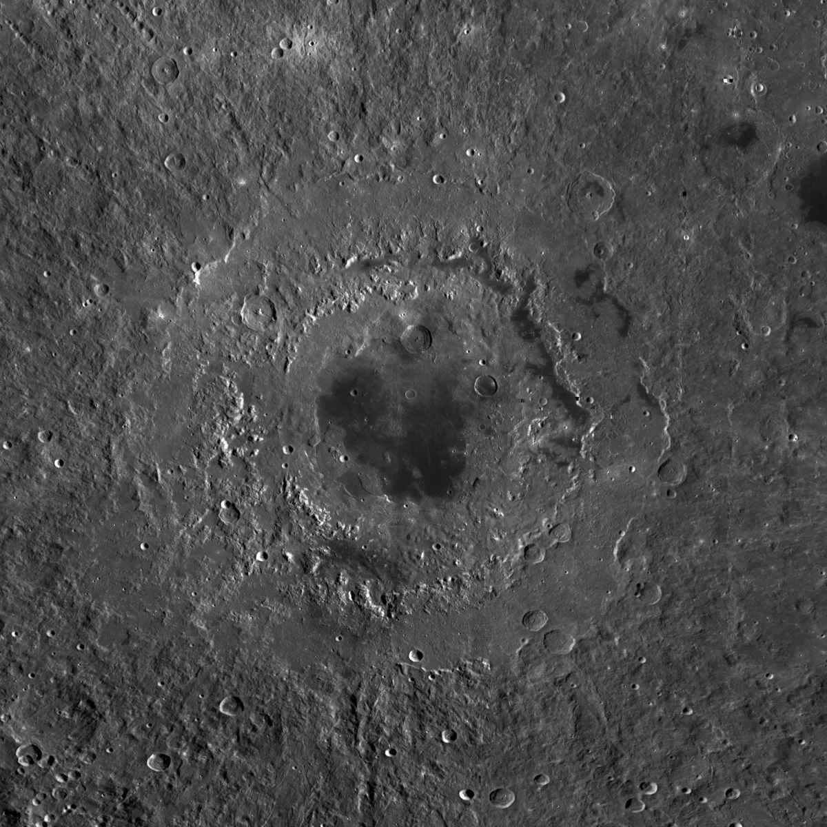
And it also turns out that my excitement for the GRAIL results -- from its low-altitude overflights of Orientale basin on the Moon -- was premature. Unlike photographic missions, GRAIL's science depends upon months worth of supercomputer time crunching on its data. Maria Zuber had only had the results of the supercomputer work on the Orientale data for two days before presenting at the meeting. (She joked that all of the data are already public, so you can try to reduce it yourself "if you dare".) The results look beautiful -- she showed that the gravity data clearly picks out the different rings and structures of the eastern side of Orientale, and that the different parts of the basin have distinctly different signatures in the gravity data -- but it's too early for much interpretation. But Maria shared some early speculation and is always good for some memorable quotes. With this data set, she said, they have the "highest-resolution orbital gravitational field model of any structure in the known universe." Orientale has three clearly visible rings. From center to outside, they are Inner Rook, outer Rook, and Cordillera. Maria reported a "fascinating" mass excess in the Cordillera (in geophysical parlance, it is Bouguer positive), which could be due (she speculated) to lower-than-usual porosity or to magma injections into the rock. The Inner Rook also has excess mass, which she speculated resulted from crustal thickening. She concluded: "If we can't figure out multi-ring basins with this data set, then too bad for us." She said they'll be writing up the results of this mission phase over the summer.
So much for the major news events for this meeting. On to the middles of hundreds of stories. Here are some vignettes.
David Williams floated a new time-stratigraphic system for Vesta that looks a lot like the ones for the Moon and Mercury. Except, he noted, that Vesta's geology didn't seem to support the setting aside of a most-recent rayed-crater epoch on Vesta. The epoch names are Pre-Veneneian, Veneneain, Rheasilvian, and Marcian -- each named for prominent craters. Since the mission team has two different chronology calibrations to absolute time scales that disagree by billions of years, it's not really possible to make direct comparisons to the histories of the Moon and Mercury.
There was a whole morning session on Titan lakes that I attended lots of; I hope to write those results up separately. In the meantime, here's a nice BBC article on two talks I missed on waves and currents in Titan's seas.
There were lengthy presentations by not one, but two, Apollo astronauts: Jack Schmitt (Apollo 17, and the only geologist ever to perform fieldwork on another world), and Dave Scott (Apollo 15). I had mixed feelings while watching these talks, as did many in the audience, I'm sure. These men are national heroes, of course. And there's no question that the Apollo missions continue to fuel productive science, more than 40 years after they happened: "We can conduct missions to the Moon repeatedly with the sample collections that we have," Schmitt said. On the other hand, with all that we've learned in the last 40 years, we'd select much better sampling targets now, if we could only go back. And just imagine what we could do with samples from Mars. Schmitt's statement also made me reflect on the fieldwork being performed right now by the Mars Science Laboratory and Mars Exploration Rover missions. If we are still learning from Apollo now, then let's have some patience for the results from the rovers. We're still collecting data, still tying it together with data from other sources -- we'll have productive science from those missions for decades to come. As long as people continue to fund ongoing analysis of the data, that is.

Speaking of which, Ray Arvidson talked about recent work by Opportunity at Endeavour. I hadn't appreciated earlier that one of the criteria they're using to select places for Opportunity to study is to locate patches of ground of one kind of rock that are large enough to occupy a significant fraction of a single CRISM pixel. (CRISM is an imaging spectrometer on Mars Reconnaissance Orbiter, the highest-resolution one ever sent to Mars, but its pixels are still many meters square.) Opportunity has few remaining science instruments, making it really challenging to determine mineralogy (though not impossible; the science team is getting really creative with analysis of the elemental data from APXS). If they can get elemental analysis of a big patch of ground that they can study from orbit with CRISM, they can be a lot more confident in their mineral identifications. For example, they went to a site called "Black Shoulder" because of strong CRISM evidence for gypsum there; they found it to be a coarse-grained sandstone containing gypsum and minor kieserite. (Gypsum is a calcium sulfate; kieserite is magnesium sulfate.) They drove to a site called "Moreton Island" because, in Ray's words, "it's a big honkin' outcrop" good for study with CRISM. Unfortunately, CRISM, too, is showing signs of age; the data are noisier because the detectors can't be kept as cool now as they could when Mars Reconnaissance Orbiter first arrived.
Larry Crumpler gave an update on the stratigraphy for the Endeavour region they're developing from Opportunity's fieldwork. He pointed out that the Matijevic formation -- which contains the clays that Opportunity drove to Endeavour to study -- represents a paleosurface, the very very ancient surface of Mars from a time when it was more clement -- and that the paleosurface was very rapidly buried and preserved by impact ejecta. He suggested that impact ejecta can preserve the kinds of things (such as, organics) that we imagine get preserved by burial under river deposits. Then he looked at the structure of the Endeavour rim and pointed out how odd it is that the layered rocks dip into the crater. Look at any cross section of an impact crater and you'll see previously flat-lying beds of rock usually wind up dipping outward (because of the raising of the crater rim during the impact process).

I attended lots and lots of Curiosity-related talks all week long, hoping for new material, but again, it was mostly incremental developments on top of stuff I've already reported, a lot of it very interesting, but I'd really rather wait to write the work up thoroughly until there are publications about it, so I can spend more time on conclusions and interpretations and less time on methods and observations. I was most interested in Aileen Yingst's talk on all of the very different kinds of conglomerates Curiosity has been seeing at the different science stops, particularly Altar Mountain and Bardin Bluffs during the Darwin stop. Those two conglomerates have very different appearances, which implies they were made in different ways or in different environments.

The Altar Mountain and Bardin Bluffs conglomerates are separated, Becky Williams said in a later talk, by a very thin bedded sandstone. Becky also showed that the veins in the Darwin outcrops told a very different story than the veins in the Yellowknife Bay stop. At Yellowknife Bay, the veins were filled with calcium sulfate, and the veins intersected each other at high angles -- an isotropic stress environment. At Darwin, 1.8 kilometers to the southwest, there was "no evidence for gypsum." And the veins were parallel, in a pattern geolgists call "en echelon," a very different stress environment from Yellowknife Bay; Becky stated that the shapes of the veins implied the outcrops at this location had been buried by tens of meters of rock at one point.
Lauren Edgar looked closely at the geology of the Shaler outcrop, interpreting it as dunes migrating across a river bar. I thought it was interesting that she found evidence for both sustained flow in the river (multiple sets of bedforms migrating over each other) and episodic or intermittent flow (because there are dessication cracks and evidence for wind-related reworking of river-deposited sands in some places).

On Tuesday, I saw an intriguing talk by Gal Sarid titled "Mercury, the impactor." MESSENGER data has invalidated almost every preexisting model for how Mercury formed, so theorists are trying to come up with new scenarios that match the data better: how it has such a large iron core, and how it didn't lose volatile elements like potassium and sulfur. Sarid suggested that Mercury is the core of a protoplanet that performed a hit-and-run impact of a larger protoplanet (he didn't mention which one, but I wonder if Venus is an option), and, in the process, lost much of its mantle. He had simulations that showed that this could work.
Steve Desch tried to solve a formation mystery at the other end of the solar system, Pluto. His talk hinged on the observation (made by someone else, that even differentiated worlds in the outermost solar system likely have upper, undifferentiated crusts several tens of kilometers thick, so impacts between "differentiated" bodies will still fling around a lot of material with a density intermediate between ice and rock. He favors a model for the formation of the Pluto-Charon system in which two differentiated bodies collide.

There were several talks exploring the geophysics of different kinds of tectonized terrain on Enceladus that left me with the feeling of the story of the blind philosophers and the elephant, particularly because Michael Bland described the terrain between the tiger stripes at Enceladus' south pole as "elephant-skin terrain." (He also called it "funiscular terrain," which apparently means "ropy." I overheard a lot of other people accidentally calling it "funicular terrain," which made me chuckle every time.) Another talk, by Emily Martin, suggested that a class of feature on Enceladus called pit chains has a global pattern that implies that Enceladus' whole crust is decoupled from its core, something that's been suggested for Europa and which is one possible piece of evidence for a global ocean, but that would contradict other evidence that any melting on Enceladus happens only close to the south pole, so I wasn't sure what to make of it.
On Wednesday, I went to several Mercury talks. Dave Paige talked about the deposits at the poles that we're now pretty sure are ice, but which are covered by a very very dark deposit that the MESSENGER team has proposed to be organics in the past. He had some cool new maps where he showed that much of the polar region likely contains very small cold traps -- little divots in the surface that result in small regions where the Sun never (or only rarely) shines. These match well to equally cool new maps of polar albedo that they made from laser data; I'm looking forward to the publication of that map and will write more about this work when it's available.
Carolyn Ernst talked about the Mercury polar craters that host water ice, and showed that their shapes are different from the assumed simple bowl shape that was used in earlier modeling work on the stability of ground ice near Mercury's poles. The actual shapes are shallower than the theorized shapes. You might think that shallower craters are less good at trapping ice than deeper craters, but in fact it doesn't work that way; deeper craters, with steeper walls, have Sun-facing rims that reflect more light into "permanently shadowed" regions, making ground ice less stable there. So shallower craters turn out to be better at trapping ice than we thought, and explain how there's ground ice detected in smaller craters farther from the poles than was theorized before MESSENGER got there.
Larry Evans talked about MESSENGER's detection of chlorine at Mercury -- another of the string of surprise discoveries of a relative abundance of relatively volatile elements on Mercury's surface. Chlorine amounts to 0.14 +/- 0.03% of Mercury's surface, by weight. But it's up to 0.35% at the north pole. These volatile elements may migrate around Mercury due to solar heating. Evans also mentioned something I'd like to learn more about: that chlorine is a major absorber of thermal neutrons, so its presence in Mercury's crust could account for neutron measurements made during the Mercury flybys that were assumed to be a result of the presence of iron and titanium, which was confusing at the time because it contradicted Mariner 10 results.

Skipping to Mars, I saw several talks on the formation of central-mound craters in general and Gale crater in particular based on orbital data, but none left me any more convinced than the various papers I've read on the subject and reported on before. I feel like there's not much more point in reporting on how Gale formed until we have more results in hand from Curiosity.
I saw lots of talks on water-carved features on Mars. The most notable of these was, I think, Tanya Harrison's, if only because of her casual statement that she has inspected 50,000 CTX images to record the presence or absence of gullies. Yes, you read that right. Fifty thousand. And CTX images have a lot of pixels in them! Her global maps show very systematic relationships: closer to the equator, gullies predominantly form on pole-facing slopes; while in middle latitudes, gullies prefer to form on equator-facing slopes. This trend is clearer in the south than in the north. In the south, most of the gullies form outside areas where climate models predict the accumulation of ice. Tanya hypothesized that we see gullies forming where katabatic winds flow off of the edges of ice sheets. Right now, those ice sheets are at the poles, but in the past and episodically when Mars axis is more strongly tilted than it is now, Mars' ice sheets from in a band encircling the equator. A worrisome note from Tanya's and others' talks: not everybody means the same thing by the word "gully." So you have to be really careful comparing studies. Tanya's definition requires a gully to incise a slope.
On Thursday, I saw a few talks on some interesting Earth field sites on dunes, analogs to Titan and Mars. I especially liked Shan de Silva's field site in Argentina, where he was studying "dunes" that are covered with very large gravels that it seems kind of impossible could be carried by wind. They look like dunes, but they aren't; they're patchy gravels eroding out of a volcanic rock that then act as traps for windblown sand, and as sand percolates down between gravels they actually it actually raises the gravels upwards over time. Weird.
There were other impact-related talks on Thursday. I thought Stephanie Quintana's work looking at "blast zones" around Martian impact craters that are really only visible in THEMIS nighttime infrared data was very cool. She did experiments and models that suggest that it's much, much easier to make these blast zones if there is quite a thick layer of ice in the Martian surface when the impact happens -- it generates a huge amount of vapor that turbulently scours the surface with the spreading blast wave of an impact.

There were some beautiful talks looking at changes on Mars. Ingrid Daubar talked about monitoring the sites of fresh impact craters for the evolution of their dark rays and haloes; her talk was full of beautiful photos like the one above. Matt Chojnacki talked about monitoring the motions of dunes within Endeavour crater. Oddly, the dunes on the east side of the crater move faster than the ones on the wst side. One of the coolest places they are now monitoring for change is in the sand dunes at the base of Mount Sharp; Nathan Bridges reported on that monitoring work, using Curiosity's ChemCam Remote Micro-Imager to perform very long-distance imaging of the dunes to watch them for motion. They haven't noticed any detectable motion yet, but the rover is still pretty far away.
The Curiosity SAM team gave an update on their attempts to determine whether SAM has detected organics on Mars or if it's just Earth contamination. Their reports were fairly similar to what I saw at the DPS meeting in October, but both Caroline Freissenet and Danny Glavin sounded more confident than they were before that they have, indeed, measured organic materials that came from their Martian sample. They still can't say whether these originated on Mars or in meteorites that landed on Mars, but they seem pretty confident that they didn't come from Earth.
A little later in the session, Heather Franz presented on carbon and sulfur isotopes. I wish I understood this work better, but I'm not too knowledgeable about isotopes; I hope I don't mangle this too much. She showed that the Cumberland sample had a negative sulfur isotope 34S anomaly, in contrast to John Klein. The negative sulfur was "way outside the range of anything seen in Martian meteorites, more along the lines of what's seen on Earth in biological sulfates." (Please note she was in no way suggesting she'd found evidence for a biological process here. It's just one intriguing observation, worthy of further study.) The difference between John Klein and Cumberland is "striking and repeatable." She said laboratory studies are under way to understand what it means, and that they are checking into possible correlations with the release of organics. (I asked on Twitter about what this meant, and Nicholas Heavens told me "Negative isotopic shifts in 34S are due to sulfate reduction, for which biological and non-biological pathways are both of interest." Franz pointed out that visual inspection of the two drill holes shows differences in veins and concretions within the samples. But she did not offer any speculative interpretation of why there was this difference between the two drilled samples; it's too early yet.

There were lots of talks on ground ice on Mars. It's sort of hard for me to fathom how "normal" it's become to discuss vast deposits of ground ice on Mars. But two radar sounders, SHARAD on Mars Reconnaissance Orbiter and MARSIS on Mars Express, have pretty convincingly detected quite a lot of it. Cassie Stuurman showed how SHARAD radargrams are consistent with what you can read from surface geology if you assume that SHARAD's radio waves are penetrating a surface layer of ice -- really quite pure ice, no more than 5 to 15% rock or dust by volume -- that is 90 meters thick in parts of the Utopia basin. (Wow.)
Joe Levy attempted to get a handle on just how much ice is stored in Mars' glacial deposits, and after much undergraduate student labor to map different kinds of ground ice deposits across the globe, calculated that we're talking about enough water to cover all of Mars to a depth of about 2.3 meters. Which sounds like a lot, but it's dwarfed by what's in the visible polar caps (enough ice to cover all of Mars to a depth of 30 meters). Crater counting on the mapped deposits suggests that they actively formed for a period of more than 700 million years, a period that ended only 100 million years ago. I'm always suspicious, though, of numbers that say that something ended so close to the present. That's entirely too convenient. Maybe it means the activity was cyclical or rare, with a period of at least 100 million years. Or something.
At this point, my brain was full. Actually, it filled repeatedly during the week. I feel like I got a snapshot of the current status of the field, but had a hard time walking away with anything conclusive. That's the nature of a scientific meeting, I guess. Especially one that's occurring in between major mission events.
Next year there will be some very big events that should generate some more sensational news: Rosetta's work at comet Churyumov-Gerasimenko, and possibly the first results from the Philae lander. Also the recent passage of comet Siding Spring at Mars. And it'll be too early for science results yet, but we'll all be squinting at the first low-resolution images of Ceres from Dawn and Pluto and Charon from New Horizons, trying to read them to see what they tell us.
For more chatter from the meeting, including lots and lots of talks and posters that I missed, search Twitter for the hashtag #LPSC2014:
Protect Our Shared Future
You help us defend humanity and prevent asteroid impacts. Donate now to become a Planetary Defender!
Donate