
 Explore Worlds
 Find Life
 Defend Earth


Curiosity Update, Sols 2257-2312: Drilling at Rock Hall and Arrival at the Valley of Clay
Written by
Emily Lakdawalla
February 6, 2019
Two thousand, three hundred and two Martian days. That is how long it took from landing day for Curiosity to reach the “clay-bearing unit.” The clay-bearing unit is a region at the base of Mount Sharp where Mars Reconnaissance Orbiter spotted unmistakable signs of a potentially habitable ancient environment, clinching the choice of Gale as Curiosity’s landing site. It's the green stripe on this map, which was instrumental in the selection of Gale as a landing site.

Of course, Curiosity has discovered lots and lots of evidence for ancient habitable environments in Gale -- not to mention plenty of clay -- on its way to the clay-bearing unit. But it’s a relief to finally get to the place that the team has been looking forward to for so long. On the map below, Curiosity crossed into the clay-bearing unit at the little square at sol 2302.

In this update, I’ll discuss Curiosity’s final work on the top of Vera Rubin Ridge, walk through the plans for the clay-bearing unit campaign, and provide brief updates on a regional dust event and progress on the recovery from the B-side computer anomaly. I’ll briefly mention some of the science that’s come out in the recently released 2019 Lunar and Planetary Science Conference (LPSC) abstracts -- if you can’t get enough Curiosity science (or any other planetary science, for that matter), you’ll find lots and lots of great stuff in those abstracts! Thanks as usual to project scientist Ashwin Vasavada for filling me in on the details of operations over the last 2 months.

Drilling at Rock Hall (sols 2257-2296)
I’ve described in previous updates how difficult drilling on Vera Rubin Ridge has been. So it’s a relief to be able to write that, as of sol 2261, with a drill hole at “Rock Hall,” the Curiosity team completed their planned drill campaign at Vera Rubin Ridge. They got 3 drilling sites atop the ridge and 1 in rocks just below it to the north.

Rock Hall was an uncomplicated drill site. The drill penetrated easily, to a depth of 43 millimeters (40 was the commanded depth), and didn’t need a high level of percussion to do it, only average 2.3 (maximum 4) out of 6. They delivered to CheMin on sol 2264 (before an operational hiatus over the December holidays) and to SAM on sol 2281 (after), and “doggie bagged” one more sample in SAM on sol 2286, for future analysis.
The timing of the CheMin delivery was perfect for the team to write abstracts for LPSC summarizing their first impressions of the science of Vera Rubin Ridge. An abstract by Frances Rivera-Hernández and coworkers shows that there are definite changes in grain size in the rocks as Curiosity drove up the ridge; maybe that says something about how they were deposited, or how they were altered after deposition. Dick Morris and coworkers summarized the mineralogical analyses. The observations: Duluth, Stoer, and Highfield drill sites -- in the Murray formation, Pettegrove Point member of the Vera Rubin Ridge, and gray Jura member of the Vera Rubin Ridge, respectively -- look surprisingly similar, while Rock Hall (red Jura) looks like a “very different mineral assemblage.” Very weirdly, Highfield (the gray rock) has quite a bit of hematite in it (so why is it gray and not red?). Elizabeth Rampe and coworkers suggest that maybe what the orbital spectroscopists thought was hematite was actually a mix of hematite and other iron-bearing minerals.

Early results on Rock Hall show more akaganeite (a chlorine-bearing iron hydroxide) than hematite, which is also puzzling. SAM results (PDF) are consistent with the CheMin results, but no less puzzling. Akaganeite is a mineral that Dick Morris has written about a lot before -- at Mars Exploration Rover science sites. Geologists find it in acid weathering environments, not the kind of pH-neutral lake environment that Curiosity most often sees in the Murray mudstones. It's a contradictory chemical story to see akaganeite in the same places that you see clays. It’s all mega confusing and doesn’t match the hypotheses the science team had as they approached work at Vera Rubin Ridge. LPSC is going to be entertaining -- hopefully there'll be a little more clarity on what this all means by then!
Clay Unit Campaign
Curiosity has examined rocks bearing clay minerals before, but these rocks are special because the clays are clearly detectable from orbit. The CRISM instrument on Mars Reconnaissance Orbiter sees the distinct signature of smectite, a mineral that was also important to the water story on the Mars Exploration Rover mission. In fact, if these particular smectite signals had not been detected from orbit, the Curiosity would most likely have selected a different landing site.


It took more than 6 years to reach the clay-bearing unit, but we’re finally there, and with all the instruments still working (except the wind sensor). The team is very ready to do science. The clay-bearing unit covers a fairly large area, so Curiosity won’t be performing multiple passes around the same terrain like it did at Pahrump Hills or Vera Rubin Ridge. Instead, it will do traverse science, starting and completing work as it rolls along a Z-shaped path.
The first leg -- the top of the “Z” -- will see Curiosity driving northeast, along the southern side of the ridge. Geologists (including me!) are very interested in exploring how the clay-bearing unit relates to the ridge. Does the unit underlie the ridge? If so, why doesn’t it crop out on the north side? Maybe it’s a surficial deposit in a preexisting trough between the ridge and the mountain? The northeast leg will take them to the lowest-elevation spot south of the ridge (and therefore, probably, into the oldest rocks to be found adjacent to Mount Sharp). That spot happens to coincide with the strongest smectite signal, so it’s highly likely Curiosity will drill there if not before.
After drilling the clay, Curiosity will turn southwest, driving straight uphill and therefore straight up the stratigraphic section, reading the rocks’ history as it goes. The geology mappers have divided the clay-bearing unit into two subunits: a “smooth ridged unit” and a “fractured unit.” The rover will transect the clay-bearing unit, while the science team tries to figure out what changed between those two subunits. They will probably drill once in each of them.
The transect will end at the Greenheugh Pediment, what looks like (but might not be) the erosional remnant of an ancient alluvial fan or delta. (For a deeper look into what the Greenheugh Pediment looks like, see this LPSC abstract by Alex Bryk and coworkers.) There’s a fair amount of topography separating the clay-bearing unit and the Greenheugh Pediment, so Curiosity will be forced to turn aside and drive east along the pediment base. It should be really interesting to see what’s exposed in the steep slopes at the toe of the pediment. Curiosity will keep rolling east until the team finds a way up onto the pediment, and may need a long detour of several hundred meters in order to safely avoid a large patch of basaltic sand. Once they've found a way up, they'll drive into the steeper terrain of yardangs and canyons atop it.
Ashwin told me that they’re beginning to plan ahead to the days when diminishing power from the decaying nuclear power supply limits the rover’s activities. He said their goal is to be up on top of that pediment and driving into the valleys within 3 to 4 years from now. That seems doable. That’s equivalent to the amount of time between when they left Pahrump Hills (on sol 753) and arrived at Vera Rubin Ridge (on sol 1812). In that time they drilled 10 times, scooped twice, and traversed nearly 10 kilometers.

Dusty Skies
A recent southern hemisphere dust event has made the distant Gale crater rim hard to see in Curiosity images for a few weeks. Ashwin told me that the meteorology team had been monitoring the storm’s development just in case the regional storm turns into a global one. But the storm is waning now, and they’ve stood down the dust storm observation campaign. Mars weatherman Mark Lemmon told me that “Tau was rising to high but seasonal values (from low for the season) by 2287, got to about 1.6 on 2295, and has fallen slowly back to the high end of seasonal (1.2-1.3).” (“Tau” is a measure of atmospheric opacity; higher tau, more opaque.)
Brittney Cooper and Claire Newman talked about the dust storm and dust devils at length in a JPL update from sol 2292:
When the regional or global dust loading increases, it changes how the atmosphere expands and contracts in response to solar insolation, which affects how air moves around and alters the large-scale patterns of surface pressure (since pressure is caused by the mass of air in a column over the surface). We monitor this by seeing how the shape of the daily pressure cycle changes from sol to sol. More atmospheric dust also means more of the incoming solar radiation is absorbed before it reaches the rover, so daytime near-surface and ground temperatures decrease compared to normal. At night, however, the warmer overlying atmosphere emits more thermal radiation, keeping the temperature of the surface and near-surface warmer than usual. More dust heating also means that near-surface and surface temperatures are more strongly coupled, resulting in a reduced surface-to-air temperature contrast, all of which REMS measurements are starting to show.
B Side Anomaly Update
Engineers still haven’t determined the root cause of Curiosity’s serious memory problem on its B-side main computer on sol 2172. They don’t know whether it was a software or hardware issue. The team has engaged experts across JPL to see if anybody can suggest other ways to determine the cause, but the limited evidence from the rover has made this challenging. To enable future research into the root cause, they’ve spent quite a bit of their downlink (taking advantage of the low-activity holidays) sending down to Earth all the parts of the B-side memory that might be relevant to solving the puzzle. That effort will continue into mid-February.
After that’s done, and after they run a few more diagnostics on the B-side computer, they plan to reformat it in an effort to return it to full function. As a reminder, the B-side computer is still useful as a safe backup to the A-side computer -- the rover would be perfectly healthy if a serious problem with the A-side computer forced it to switch -- it just couldn’t do any science because it couldn’t remember any of the data. After reformatting, the team will eventually (they hope) be able to restore the B-side computer to science capability.
I will probably try to squeeze one more Curiosity update in before LPSC convenes on March 18, and then it will be time for science results! I'll leave you with this gorgeous view across the trough of clays to the Greenheugh pediment. If you look really closely (you'll probably have to click to enlarge), you'll find a CGI Curiosity has been dropped into it.

And now, the full list of Curiosity Mission Updates as originally posted on the mission website at JPL.
Sol 2257 update by Brittney Cooper: Makin' the Most of It (11 Dec 2018)
Even on Mars, where every second of Curiosity's sol is planned, things don't always go quite as expected. This morning we learned that Curiosity didn't complete her planned drive yesterday and instead stopped at the mid-drive point. We had to decide whether to finish the remainder of the previously planned drive, or bump towards a red Jura candidate and potential drill target in today's plan.
After some thoughtful discussion, we decided to make the most of where Curiosity ended up, and planned a bump toward the nearby target "Rock Hall" (located to the right of centre in the image above). Targeted ChemCam LIBS and Mastcam multispectral observations were then planned to characterize Rock Hall and confirm if it's a member of the red Jura. Tosol's bump will have Curiosity set up for drilling and in position to test the hardness of Rock Hall with a drill pre-load test and ChemCam LIBS tomorrow, if need-be. Unfortunately, the amount of pebbles on top of Rock Hall will likely prevent our ability to use the Dust Removal Tool (DRT) on the surface, but that doesn't mean that it can't be drilled.
In addition to the targeted Mastcam and ChemCam activities mentioned, a 360° Navcam dust devil survey rounded off a 1 hour science block to try and catch some late morning dust devils.
Sols 2258-2259 update by Michelle Minitti: Is THIS the red Jura we are looking for? (13 Dec 2018)
The drive around to the north side of "Rock Hall" in yesterday's plan was successful, placing us at a lower tilt and with room in the workspace to place all the piles of sample we drop on the surface (purposely!) in the aftermath of drilling. Yesterday's observations of Rock Hall gave us confidence that we were at a promising red Jura target for drilling. ChemCam rasters across three different targets on Rock Hall indicated the slab had chemistry and spectral character consistent with red Jura. Mastcam images focused on the slab demonstrated that while it was dusty in flatter areas, and covered with scattered, loose gray and red pebbles in others, the slab had the red, shiny appearance we associate with red Jura. This placed us farther down the path toward drilling red Jura than we had been with any of our previous sites!
Today's plan focused on characterizing the would-be drill target. The loose pebbles on the Rock Hall slab precluded use of the DRT, so we will acquire ChemCam, MAHLI and APXS on the unbrushed drill target itself. We will also push the drill into the target, called a pre-load test, to assess the suitability of the Rock Hall block for drilling. Whether or not we see a mark from the drill in the target after the pre-load test will give us some idea of the hardness of the drill target. The science team will scrutinize the mark from the drill (or lack thereof) carefully as a predictor of the likelihood of drilling success.
We also had time to gather data from other targets of interest both on and around the Rock Hall slab. We will acquire MAHLI and APXS on "Corrieshalloch Gorge," a slightly less dusty (and thus redder) portion of the Rock Hall slab, while we will shoot "Cluny Hill," a target on a rubbly, heterogeneous neighbor of Rock Hall, with ChemCam. Mastcam multispectral observations of "Gometra" will give us further insight into this candidate iron meteorite target, of which we have had surprisingly many in this part of the "Vera Rubin Ridge." We will image "Marsco," a small sand-filled depression that might represent a small impact crater, with Mastcam. Navcam will scan the skies for clouds and dust devils and DAN passive and active observations for H will ping the ground under our new parking spot.
May the (drill) force be with us!
Sols 2260-2262 update by Catherine O’Connell-Cooper: Go for Drill on the red Jura! (17 Dec 2018)
In our last plan, we carried out triage activities on the red Jura target, "Rock Hall," including APXS of the target to determine composition, and engineering tests to assess the stability of the rock and its hardness, both of which would affect our ability to drill.
It was decided that this would be a suitable candidate, both geochemically and physically, so today's plan will centre around the drilling of what will hopefully be our 19th drill sample for analysis on Mars!
On sol 2260, MAHLI will take a series of images to characterize locations chosen by the rover planners as the areas in which they would eventually like to dump excess sample generated by the drilling. The drilling itself will take place on the morning of the second sol (sol 2261).
Once this has completed, in the afternoon of sol 2261, ChemCam will do passive analysis (i.e., no LIBS, or laser) of the drill tailings, and image the drill hole. Both will be done "in the blind" (without confirmation images), based on where the rover planners estimate their likely location to be. We will also acquire Mastcam multi-spectral analysis of the drill tailings.
The Environmental theme group requested some Mastcam atmospheric measurements, to be run in the morning and the afternoon of sol 2262. In addition to the afternoon environmental activities, Mastcam will document layering in a hill called "Lairig Ghru." Standard REMS and DAN passive activities are spread throughout the three sol plan.
Sol 2263 update by Dawn Sumner: We have sample! (18 Dec 2018)
At the end of last week, the team made the call to drill the rock "Rock Hall," and Curiosity had no problems drilling the target. The science team had been worried that this rock type, red Jura, might be particularly hard based on the observation that it commonly caps the highs on Vera Rubin Ridge. However, the drill reached its full commanded depth on our first attempt, and we are celebrating!
Today, the team planned a portioning test to make sure that there is sample powder in the drill and that it comes out in reliable volumes when Curiosity shakes its arm. This is the next step before delivering sample to the CheMin instrument for mineralogical analysis. The rover planners included an extra portioning activity consisting of sample delivery to one of SAM's sample inlets with the cover closed. Based on prior SAM data, it appears that samples delivered to SAM are smaller than those delivered to the ground. By delivering sample to the closed inlet and then imaging the result, the team can get a better estimate of sample volumes delivered to SAM. This extra test will help us better plan future sample deliveries to SAM.
Tosol's plan also includes ChemCam analyses of the drill hole and tailings, in addition to the rock target "Arnage." Mastcam will image Arnage as well as the sample portions dropped from the drill. Environmental monitoring fills out the plan.
Although drilling proceeded without a hitch, there was an issue with the Remote Sensing Mast near the end of the weekend plan, and the Mastcam mosaic of "Lairig Ghru" was lost as were two environmental observations. The engineering team evaluated the issue and concluded that it is safe to proceed with use of all instruments. The loss of these activities was identified late in planning due to a delay in data delivery, so they were not replanned today. They will be captured in future plans.
Rock Hall is our 19th drilled sample of Mars and the last one we are planning for Vera Rubin Ridge. We are really pleased with the outstanding data Curiosity has collected for us here, and many team members are preparing abstracts to present results at the annual Lunar and Planetary Sciences Conference early next year.
Sol 2264 update by Kristen Bennett: Science and Good Times at Rock Hall (18 Dec 2018)
We are still very excited and happy that the final drill hole, "Rock Hall," on Vera Rubin Ridge was successful over the weekend. Now we get to analyze the drilled sample with rover instruments. We are planning one sol today, and the big event will be delivering some of the Rock Hall sample to the CheMin instrument.
Additionally, ChemCam LIBS is planned to target the drill hole to understand the chemistry, and a Mastcam 360-degree mosaic is planned to document the surroundings around the drill hole.
Although the drill was successful over the weekend, a few of the remote science observations were not obtained. To recover some of those observations, today we plan to retake the "Lairig Ghru" Mastcam observation that will document layering near Curiosity.
Sols 2265-2275 update by Lucy Thompson: Curiosity planning for the holidays (19 Dec 2019)
Planning today revolved around making sure that Curiosity has enough power after the Christmas holidays to be able to continue analyzing "Rock Hall," the red Jura sample that we successfully drilled last weekend. We planned and uplinked 1 sol (sol = martian day) of science and diagnostic activities and 10 sols of REMS to take us through to the end of December. Tomorrow, our final day of planning before the MSL team takes a break for the holidays, we will plan Sols 2276 - 2278 to execute on Mars before the team here on Earth returns to nominal planning activities.
The priority was to facilitate diagnostic testing of the B-side computer to help assess the rover anomaly we experienced a few months ago (see this description of the anomaly). The diagnostics require Curiosity to be awake for long periods of time, which drains her battery, and does not leave much power for other activities. Because of this, although we had tentatively planned some ChemCam LIBS and RMI observations of rock targets in the workspace, as well as some Mastcam and Navcam environmental activities, we were unable to fit them into the final plan. We were able to include some Mastcam change detection images of a couple of the sand-filled polygonal troughs in this area ("Luskentyre" and "Fishertown"), to monitor how the wind moves sand around, as well as a Navcam deck pan to observe the rover deck. Standard DAN passive and DAN active, RAD and REMS activities round out the plan.
Sols 2276-2278 update by Fred Calef: Capturing Light into the New Year (21 Dec 2018)
As we cross the winter solstice and daylight lengthens here on Earth, the Vera Rubin Ridge campaign on Mars is shortening up towards a science-filled end 'capturing the light' across all its splendid spectrum. On sol 2276, the plan includes a CheMin analysis to illuminate the drill sample "Rock Hall" in X-ray light, staring at the plasma glow from the ultra violet through the visible into the near infrared (what you see with your eyes and slightly beyond) from ChemCam on bedrock targets "Auchenheath," "Firth of Forth," and "Port Charlotte" as well as a panchromatic (artsy black and white) RMI mosaic of the large white vein "Hopetoun." All these targets also get viewed in their red-green-blues (i.e. color) using Mastcam. Additional change detection Mastcam images are planned for targets "Fishertown" and "Luskentyre" to see how the soil moves around in the thin martian atmosphere. Navcam will make a 'movie' (multiple frames taken close in time) of dust devils dancing across the flat Aeolis Palus plains including a line-of-sight observation to record atmospheric dust density. Mastcam will stare wistfully at the crater rim to help characterize dust and a solar tau observing aerosol (i.e. dust and such) scattering properties in the air. Some pragmatic Navcam sky flats taken on sol 2277 help monitor camera lens cleanliness along with Rock Hall CheMin data sent home as a parting gift from 2018. On New Year's Eve, a ChemCam Passive observation (no laser) will ring out the evening and another in the predawn hours of sol 2278 for the first observation of the New Year! The second day on the new Earth year has Curiosity gazing out into the distance, perhaps thinking of its science resolutions to get to the clay flats just to the south, with Navcam line-of-sight (LOS), suprahorizon, and cloud-watching zenith movies, as well as a Mastcam solar tau, crater rim extinction, and sky survey observations. Happy New Year to all as we welcome more Mars science to come in 2019!
Sols 2279-2280 update by Claire Newman: Happy 2019, Earthlings! (4 Jan 2019)
The holiday planning completed successfully and included 10 sols of five-hour-long morning meteorological observations by REMS, during the period when more complex activities were precluded. The main goals for the Sol 2279-2280 plan were to catch up on our other regular atmospheric monitoring activities, which were largely on hold over the holidays, and to prepare for drop-off of the "Rock Hall" red "Jura" drill sample into SAM for analysis.
A dust devil 360° image search and 30-minute movie pointing to the south-west were added in the late morning on sol 2280, with REMS covering the same time period; this allows us to see if any of the dusty vortices found by imaging coincide with vortex-like (sharp, short-lived) pressure drops in the REMS pressure data. In addition, the atmospheric column opacity, as well as the amount of dust between Curiosity and the crater rim, were measured in the morning and afternoon, with morning and afternoon 'cloud search' movies added too, plus regular RAD and DAN passive measurements.
To look for surface changes indicating wind strength and direction over the holiday break, we also added Mastcam imaging of targets "Luskentyre" and "Fishertown" at ~15:30 on Sol 2280, to match imaging of them at the same time (and hence the same lighting conditions, making it easier to spot changes) on Sols 2266 and 2276. The three images of each target will be analyzed to look for changes in position of sand grains or ripple crests (such as those seen in the image of "Luskentyre" from sol 2276) over the intervening sols.
SAM pre-conditioning during this plan would normally have been joined by a ChemCam passive measurement of the drill hole, but as this is a big measurement the ChemCam team recommended re-imaging the target first, in case the rover had shifted a little over the long break. So an RMI of the Rock Hall target was added in this plan, with the full ChemCam measurement postponed until the imaging has been assessed. In addition, to build up statistics on local bedrock variability, we added ChemCam passive measurement of targets "Port Askaig," "Portnockie" and "Bothwell."
Sols 2281-2283 update by Vivian Sun: It's a wonderful day for SAM! (7 Jan 2019)
Today we are continuing the drill campaign at our red Jura target "Rock Hall." The focus of this weekend's plan is the dropoff of the Rock Hall sample to the SAM (Sample Analysis at Mars) instrument, which will occur on Sol 2281. During the delivery process, Curiosity will open one of the SAM inlet covers (pictured above) and the rover arm will deposit a portion of the fine rock powder from the drill bit. SAM will then incrementally heat the sample up to very high temperatures and the gases released by this heating process will be analyzed to better understand the chemical and mineralogic components of Rock Hall. The SAM results will be extremely important for complementing the chemical observations from APXS and ChemCam, as well as the recent mineralogic results from CheMin.
There was also plenty of time for other science observations in addition to SAM. On Sol 2282, we will survey for dust devils with Navcam, and will also take ChemCam measurements of the Rock Hall drill hole to fill out our suite of data for this drill target. On Sol 2283, we planned two science blocks, starting with an early morning block dedicated to atmospheric monitoring activities. Afterwards, we will take ChemCam measurements of "St Cyrus," a workspace target intended to continue our documentation of bedrock in this area, and "Gometra," a target that may be a meteorite candidate. We will also be taking a Mastcam right camera image of "Gruinard Bay," which is a displaced slab that was identified in the Mastcam left camera images as having edges with interesting textures and color variations; the higher resolution of the Mastcam right camera will allow us to take a closer look at these textures and the interactions between this slab and the regolith around it.
Overall, this was a pretty smooth planning day today, especially for me as the Geology Keeper of the Plan, and we're looking forward to seeing the results from SAM soon!
Sols 2284-2285 update by Mariah Baker: A spectra-cular Monday on Mars (7 Jan 2019)
Today was a very smooth planning day on Mars, with the first scheduled science block in the plan being entirely filled by various spectroscopic ChemCam observations. The ChemCam instrument has the capabilities to be used in both passive and active modes, both of which were included in today's plan. ChemCam active observations, which require shooting a laser at specific rock targets and analyzing the resulting plasmas, will be acquired for "Coatbridge" and "Pitscurrie," two small rock outcrops in the rover's vicinity. Altogether, these observations will help us determine the spectral characteristics of the local geology, and the associated Mastcam documentation images of Coatbridge and Pitscurrie will provide geologic context for these measurements. The second scheduled science block, which coincided with an extended stretch of REMS monitoring, was dedicated to environmental observations such as Navcam movies looking for dust devils and clouds.
The two Chemcam documentation images included in the first science block were the only Mastcam observations planned today; a large Mastcam mosaic designed to image some upcoming features on Mount Sharp was pushed into Wednesday's plan. Wednesday's plan will also be influenced by a forthcoming decision from the members of the SAM (Sample Analysis at Mars) team, who are working diligently to analyze data acquired over the weekend and will soon make a decision as to whether additional samples are desired before we leave the Rock Hall location.
A Front Hazcam image taken on Sol 2282 shows part of the landscape around the rover, including some of the rocks that will be analyzed further with ChemCam.
Sols 2286-2287 update by Catherine O’Connell-Cooper: Starting the wrap-up at Rock Hall (10 Jan 2019)
Our onboard instruments SAM (Sample Analysis at Mars) and CheMin (Chemistry and Mineralogy) have come to the end of their investigation of the Rock Hall target, likely to be our last drill location on the Vera Rubin Ridge, so this 2-sol plan is the beginning of the drill operation wrap up. On the first sol (2286) SAM will "doggie bag" some sample, saving it for further experimentation in future weeks. The second sol of the plan (2287) will centre on preparations to "dump" the remaining sample from the drill onto the ground in the weekend plan, so that it can be analyzed by APXS, MAHLI, Mastcam and ChemCam. For example, Mastcam will image the Rock Hall drill hole, to monitor the degree of movement of the drill fines in the 3 weeks since our drilling.
The Geology (GEO) theme group planned ChemCam LIBS observations on four targets within the workspace. "Deveron" is a typical bedrock target, to help further characterize the bedrock in this area. "Burra" has an interesting pitted texture, whilst "Braeriach" has a shiny appearance. "Gometra" is a potential iron meteorite, which has been previously targeted, but warranted further investigation. Mastcam will take colour images of the LIBS targets, in addition to remote sensing of the "Greenheugh" pediment, further up the slopes of Mount Sharp. The Environment (ENV) theme group is continuing to document dust levels in the atmosphere, via a Mastcam sky column activity, and a full tau/extinction pair of images. Additionally, DAN passives and standard REMS activities are throughout the plan.
Sol 2288-2290 update by Susanne Schwenzer: Drilling activity completed, almost. (11 Jan 2019)
We will soon be leaving the Rock Hall area, thus this one last look at the drill site from a hazard camera perspective. Seeing those holes always is special, even for #19!
In today's planning, we will dump the remaining rock powder from the drill and investigate it with all instruments, starting with APXS, which will perform a two-step raster. Sol 2288 contains a range of ENV investigations, dedicating the morning science block on sol 2288 to a passive sky observation and a Mastcam tau to see how the dust loading in the atmosphere is changing. The science block of sol 2289 is dedicated to spectral analysis of the dump pile with ChemCam passive and Mastcam multispectral investigations.
ChemCam is holding off on its active LIBS observations of the dump pile until we know that APXS and the spectral analysis completed successfully, thus there are two bedrock observations in the sol 2290 plan, the targets are Dufftown and Lairg. Both will be investigated with 10-point rasters to further capture the bedrock variability we have been seeing. Monday's plan will be the last one at Rock Hall before we start our descent of the ridge and into the clay unit. I am excited to explore the new terrain, and so is the entire team!
Sol 2291 update by Rachel Kronyak: Selfie time at Rock Hall: say cheese! (14 Jan 2019)
Today we planned a single sol of activities, Sol 2291. As we begin to wrap up our activities at the Rock Hall drill site, Sol 2291 is chock full of science observations. We'll begin the sol with an hour-long science block. Our environmental group (ENV) planned several activities to measure increasing dust levels in the atmosphere; these observations will occur at the start of the science block. Following ENV's activities, the geology group (GEO) planned a ChemCam observation on a soil target near the rover named "Loch Monar" as well as a long-distance Remote Micro-Imager (RMI) image of the sulfate unit on Mount Sharp. Following ChemCam, Mastcam will take images of targets "Loch Monar" and "Stroma." The "Stroma" target is an interesting small rock just in front of the rover.
After the science block, we will take a series of images with our MAHLI camera. First, we'll take a 57-frame self-portrait (or selfie). Up next for MAHLI is part one of a wheel imaging campaign, which we do periodically to monitor the health of the wheels. We'll take several images today, and more images after we drive later on in the week. Overnight, APXS will perform an analysis on the Rock Hall dump pile. This will be our second observation on the dump pile; our weekend analysis didn't get the entire pile within APXS's field of view.
Tuesday is a no-planning "soliday," which happens approximately every 38 days. These solidays allow our Earth schedule to catch back up with the slightly longer Mars day. We will resume planning Sol 2292 on Wednesday.
Sol 2292 update by Brittney Cooper and Claire Newman: Dust to Dust (17 Jan 2019)
Today was our last day at "Rock Hall," so it was our final chance to get every last bit of science at this location. We had a 2.5 hour science block filled with Mastcam change detection imaging of the Rock Hall drill fines and alternating ChemCam RMI and LIBS observations of the Rock Hall dump pile, drill tailings, and target "St.Cyrus 2." The ChemCam activities were followed by Mastcam documentation images of each of the aforementioned targets, and we also included a B-side computer diagnostic and an overnight APXS of the Rock Hall drill tailings.
Gale Crater has become a lot dustier in recent sols due to a regional dust storm in the southern hemisphere that was spotted by the Mars Climate Sounder team, so we added several extra environmental observations to see how this is affecting the atmosphere. These included extra measurements of the amount of dust above us (with the observation known as the "Mastcam tau") and of visibility across the crater (with the "Navcam Line of Sight" and "Mastcam Crater Rim Extinction" observations).
We also added more REMS 1-hr measurements to better capture the diurnal cycles of pressure and temperature. When the regional or global dust loading increases, it changes how the atmosphere expands and contracts in response to solar insolation, which affects how air moves around and alters the large-scale patterns of surface pressure (since pressure is caused by the mass of air in a column over the surface). We monitor this by seeing how the shape of the daily pressure cycle changes from sol to sol. More atmospheric dust also means more of the incoming solar radiation is absorbed before it reaches the rover, so daytime near-surface and ground temperatures decrease compared to normal. At night, however, the warmer overlying atmosphere emits more thermal radiation, keeping the temperature of the surface and near-surface warmer than usual. More dust heating also means that near-surface and surface temperatures are more strongly coupled, resulting in a reduced surface-to-air temperature contrast, all of which REMS measurements are starting to show.
Another effect of increased dustiness is therefore that we expect to observe fewer convective vortices and dust devils (dusty vortices), because a smaller surface-to-air temperature difference means less heat is pumped into the atmosphere to drive convection. So tosol we also included three types of Navcam dust devil searches, to see if the dust activity produces a decrease in the number or size of dust devils.
We'd normally expect to see a lot of dust devils in the current season (local summer). In fact, one passed right over the rover just as we were taking a movie a few sols before the dust began to increase! The second of the two frames above shows a slight reduction in visibility as this happened; at the same time, the dust devil's low-pressure core produced the largest vortex pressure drop ever measured on Mars (over 7 Pa, which is about 1% of the total surface pressure). Although we can't 'see' the dust devil in the images, we can tell the rover was inside one because of the decrease in visibility combined with the dramatic decrease in pressure.
Sols 2293-2294 update by Michelle Minitti: On the road again (18 Jan 2019)
It has been a productive stay at the "Rock Hall" drill site. The number and diversity of analyses performed on the drill target and drilled sample itself - mineralogy from CheMin, organics and volatiles from SAM, chemistry and spectral characteristics of the bedrock, drill tailings and excess drilled sample from APXS, ChemCam, and Mastcam - speak to the importance of samples we so painstakingly extract from Mars. After acquiring an image of the drill hole using MAHLI to pinpoint APXS's placement over the drill tailings the evening before, we depart for our next adventure - the clay-bearing unit. This unit, which lies between us and the next set of mesas further up Mount Sharp, exhibits a strong spectral signature of clay minerals from orbit. As clays are associated with the action of water and, typically, that of neutral pH waters, we are keen to learn about the nature and origins of the clays and the rocks that host them.
Our first move is a series of bumps that will scoot us forward 2 m as we image the wheels that will carry us to the clay-bearing unit and beyond. The process, called full MAHLI wheel imaging, involves poising MAHLI obliquely above the wheels to image them, stowing the arm, bumping forward a few tens of centimeters to bring the next segment of wheel into view, unstowing the arm, and imaging the wheels once again. It takes 4 small bumps to fully image the outer circumference of the wheels. The first set of wheel images was acquired by MAHLI on Sol 2291, one of which is featured above. Even with the bumps and tears visible in this image, the wheels are still capable of carrying us for many more kilometers across the clay-bearing unit and up Mount Sharp! As we bump forward to take the wheel images, we will also acquire a MARDI image at each stop, resulting in a tightly overlapping set of MARDI images that can be combined to create a digital elevation model of the terrain under the rover. The final stop will place the Rock Hall drill hole in the MARDI field of view, giving MARDI our last look at Rock Hall.
After we drive, we will image our first new workspace in about a month, acquire a ChemCam raster using the automated AEGIS targeting system, and acquire a host of Navcam and Mastcam images and movies to monitor changes in the atmosphere caused by the regional dust storm. Perhaps Curiosity will have another up-close-and-personal encounter with a dust devil!
Sols 2295-2297 update by Melissa Rice: Just can't wait to get on the road again (18 Jan 2019)
Sometimes the best laid plans of rovers go astray. After wrapping up at the Rock Hall drill site yesterday, the plan was for Curiosity to start driving towards the clay-bearing unit (our first drive in about a month), starting with a series of small bumps so that MAHLI could take images of the full outer circumference of the wheels (as described in the blog for Sols 2293-2294). However, an arm fault prevented yesterday's drive from executing, and today Curiosity remains parked in front of Rock Hall.
The good news is that we get one more day to explore this spot. Before we reattempt the MAHLI wheel imaging and the drive, Curiosity will use the DRT to brush dust off of the target Bothwell, image it with MAHLI, and collect chemical data overnight with APXS. ChemCam will explore a few more targets here as well, including LIBS observations of the bedrock targets "St Ninians Tombolo," "Stac Pollaidh" and "St Cyrus 3," and a long-distance RMI mosaic of a butte of layered sulfate-bearing rocks towards Mount Sharp. After this bonus science, Curiosity will make the first of several eastward drives to exit the Vera Rubin Ridge and enter the clay-bearing unit. When we return from the Martin Luther King Jr. Day holiday next week, hopefully we'll be greeted with images of a brand-new workspace to explore!
Sol 2298 update by Roger Wiens: Commencement of the Clay-Bearing Unit Campaign (22 Jan 2019)
Curiosity has moved for the first time since December 13, 2018. More importantly, Curiosity is moving to a new geological unit that we have so far called the "Clay-Bearing Unit" (CBU). The MSL rover team, following previous rover teams, has organized itself into different campaigns to explore different geological units. Organizers are nominated to lead these campaigns, and their job is to help coordinate among the competing interests of the different instrument teams, helping to make synergistic, collaborative discoveries. The organizers of the CBU campaign have been patiently waiting for their turn to lead the campaign. After all, their first meeting was well over a year ago, on October 3, 2017.
Curiosity has not actually arrived yet. The rover team is searching for the geological contact between bedrock of Vera Rubin Ridge and that of the CBU. The precise boundary is not clear from orbit, and it could also be a relatively gradual change as seen from rover images. To have the best chance at observing the transition, Curiosity is doing relatively short drives, interspersed with frequent observations by both remote and contact instruments, as the terrain allows.
The rover drove about 38 meters over the holiday weekend, and ChemCam made a post-drive observation using AEGIS software. Before tosol's drive ChemCam will shoot a 5x1 raster on "Oldmeldrum," 10x1 rasters on "Dyce," "Banchory," and "Elrick." ChemCam will also take a 3-image mosaic of a feature of interest in the sulfate unit. Mastcam will image all of the local ChemCam targets including yestersol's AEGIS target, and will image one additional target, "Dalmellington," which is a rock with a protrusion. Navcam will take a movie looking for dust devils, and Mastcam will take an image to check the tau (atmospheric opacity) and a crater rim extinction image. After the drive the rover will image the local terrain with Navcam and Mastcam, including a 360 degree observation with Navcam and a clast survey with Mastcam. MARDI will take a post-drive image of the ground below the rover close to sunset. DAN, RAD, and REMS will also collect data, as usual.
Sol 2299 update by Scott Guzewich: Melrose Place (23 Jan 2019)
Curiosity is continuing the first phase of its journey to the "clay-bearing unit," the low elevation portion in the middle distance of this Navcam image with a series of "touch-and-go" driving sols. During these sols, the rover does contact science with MAHLI and APXS in the morning, some additional remote sensing as time permits, and then drives away to a new location during the afternoon. We want to closely examine the bedrock as we drive to help understand how the Vera Rubin Ridge and the clay unit are related.
Today, "Melrose" was the target for contact science. Additional Mastcam and ChemCam observations were taken of other nearby geological targets. Curiosity is continuing to monitor a strong late-season dust storm that's increased the amount of dust locally for the last 1-2 weeks with Navcam and Mastcam observations of the atmosphere as well as an increased cadence of REMS meteorological observations.
Sol 2300 update by Lucy Thomson: Beam me up Scotty! (24 Jan 2019)
Curiosity is on the brink of descending down off the Vera Rubin Ridge (VRR) onto the clay-bearing unit. We are hoping to 'beam up' lots of interesting new data to the Mars orbiters, to be relayed to Earth after executing our plan on Mars tosol. We planned a typical 'Touch and Go' sol today, which includes using the arm to place our contact science instruments (APXS and MAHLI) on a rock target to document chemistry and texture, followed by remote science by ChemCam and Mastcam to also look at chemistry and the larger scale view out the front window, before a drive. We are documenting how the chemistry and appearance of the rock is changing as we transition from the resistant VRR to the less resistant, orbitally distinct clay-bearing unit, and taking larger-scale images and mosaics to assist in future planning of our investigation of the clay-bearing unit.
We chose a reddish-purple, laminated bedrock target for APXS and MAHLI and selected the name "Linlithgow," which is apparently the birthplace of Mary Queen of Scots and the future birthplace (in 2222) of Montgomery "Scotty" Scott, chief engineer of Star Trek's Enterprise (hence the title)! The great grandfather of one of our science team members also compiled an anthology of poetry from the area in 1896, so a popular choice of name! Mastcam images will be taken of this target and an adjacent, rougher textured and different coloured bedrock target, "Stoneywood" (also a ChemCam target), to look for spectral variations between the two areas. The more typical bedrock target, "Stornoway" will also be analyzed for composition by ChemCam. A large Mastcam mosaic of 21x2 images was also planned of an area named "Boyndie Bay" to document some interesting features that we are thinking of visiting during our investigation of the clay-bearing unit.
The planned drive should take us to the very edge of the VRR, and will likely be our last stop before we drive down onto the clay-bearing unit. We are acquiring images to facilitate a full weekend of science activities at this important location, as well as a post-drive DAN active measurement to investigate the distribution of subsurface hydrogen.
Additional Mastcam images and REMS meteorological observations were planned to monitor dust in the Martian atmosphere.
Sols 2301-2303 update by Ryan Anderson: Looking Forward to the Clay-Bearing Unit (28 Jan 2019)
This weekend's plan started off on Sol 2301 with some Mastcam atmospheric observations, followed by ChemCam analysis of "Loch Ness" and "Loch Skeen," examples of brown and gray bedrock. ChemCam also had a long-distance image mosaic of an interesting outcrop in the clay-bearing unit. Once the remote sensing was done, it was time for some contact science. MAHLI collected some images of Loch Ness before and after it was brushed, as well as the target "Puddledub." APXS then took a turn, with a quick analysis of Puddledub and an overnight analysis of Loch Ness.
On Sol 2302, we started off with a Navcam atmospheric observation, followed by Mastcam multispectral observations of Loch Ness and Loch Skeen. Mastcam also had a large stereo mosaic surveying the clay-bearing unit that we will soon be exploring. We then drove for about 32 meters and collected some post-drive imaging including our routine Mastcam "clast survey" to document changes in the rocks and soils along our traverse, as well as some additional Navcam images to help with imaging the pediment that is looming large just beyond the clay-bearing unit. This was followed by some Mastcam atmospheric observations and a MARDI image of the ground beneath the rover.
Sol 2303 was dedicated to atmospheric observations, with the usual Mastcam "tau" images plus several Navcam movies. Some of these were pointed at the sky to watch for clouds, while others were pointed out across the crater floor to watch for dust devils.
Sols 2304-2305 update by Christopher Edwards: In the Clay Unit (29 Jan 2019)
Today's plan found Curiosity solidly in new territory and the view couldn't be more different than the patchy bedrock of the Vera Rubin Ridge. The workspace for the next two sols of planning consisted of fine grained materials with coarser clasts interspersed.
In this plan, despite being power limited resulting in a relatively short science block, the science team managed to squeeze in some important activities to start characterizing the clay-bearing unit. These activities included a ChemCam on a target dubbed "Cyrus" to characterize the limited bedrock in the scene, Mastcam documentation images, several Mastcam mosaics and a long distance RMI to help characterize the Greenheugh pediment visible in the distance.
Despite being power limited, the team also added a contact science target to obtain chemistry of the bedrock exposed in the region. APXS and MAHLI observations were planned on the target dubbed "St. Fergus". Following these activities, the rover will drive about 15 meters, positioning itself near the top of one of the small ridges, giving a nice vantage of the terrain ahead. As Curiosity begins to explore the clay-bearing unit, it's certain that new discoveries lie ahead.Sols 2306-2307 update by Ashley Stroupe: Stepping Up to the Edge (30 Jan 2019)
In today's plan, Curiosity is venturing further into the clay unit territory.
Prior to departure, we'll be looking at several targets with Mastcam color and ChemCam to try to characterize the chemistry and texture of this new terrain. We'll also be taking a ChemCam RMI mosaic of "Buchan Ridge," an upcoming area of exploration within the clay unit, to aid in navigation and traverse planning.
We're driving up to the crest of a ridge so that we will be able to see down the other side, which is currently hidden from our view. The new terrain is so featureless, that visual odometry is having trouble tracking our position and measuring slip, which caused the rover to stop the sol 2304 drive early. The image above (Sol 2304 post-drive Navcam) shows the ridge and the smooth terrain. The rover planners are using some extra imaging to help us characterize how the rover performs on this new terrain. We are hoping something of interest will be in our workspace for contact science in the weekend plan. Much of our post-drive imaging will also be of higher resolution than usual (lossless compression) so that we can see the fine details and get good stereo for drive planning.
After the drive, we're continuing our monitoring of the weather, with Mastcam taus, dust devil movies, and some other atmospheric imaging. We'll also be using AEGIS for some automated ChemCam science, which should help us find anything interesting in this terrain.
Last, but not least, we're continuing our diagnostics to better understand our issues with the Side-B computer, dumping some more blocks of memory.Sols 2308-2310 update by Vivian Sun: Atop Another (Smaller) Ridge (1 Feb 2019)
Curiosity successfully completed her drive yesterday and is currently parked on top of one of the ridges ("Knockfarril Hill") in the clay-bearing unit. One of the mysteries of the clay unit is the origin of these ridges - how did they form and what are they made of? This weekend's 3-sol plan is packed with observations designed to start addressing these questions.
The current workspace in front of Curiosity is very rubbly, with no bedrock that is reachable by the rover arm. However, most of the clay-bearing unit is likely composed of this rubbly material, so it's important to characterize its composition and texture. To that end, we will acquire APXS measurements of this material on Sol 2308, using a rastering technique where the APXS will be placed over three overlapping spots in the workspace. By obtaining chemical measurements over different, but slightly overlapping areas, we will be able to distinguish the compositions of the pebbles from the sand and soil in the APXS field of view.
We will also analyze the variety of pebbles in our workspace with ChemCam on "Brent" (also the APXS target), "Carluke," and "Foveran." In a happy coincidence, we had identified Carluke as a ChemCam target before we learned that the previous plan's ChemCam AEGIS observation had autonomously selected the same Carluke pebble to analyze! We decided to keep the Carluke observation in any case, to gather better statistics on the chemical variability in this pebble.
We also planned plenty of Mastcam imagery given our relatively high vantage point atop this ridge. Two mosaics are planned to document the bedrock outcrop exposed at Knockfarril Hill and of a layered bedrock outcrop nearby. We will also document some intriguing aeolian ridges in the distance, as well as some enigmatic dark and bright aeolian features in an area called "Crawton."
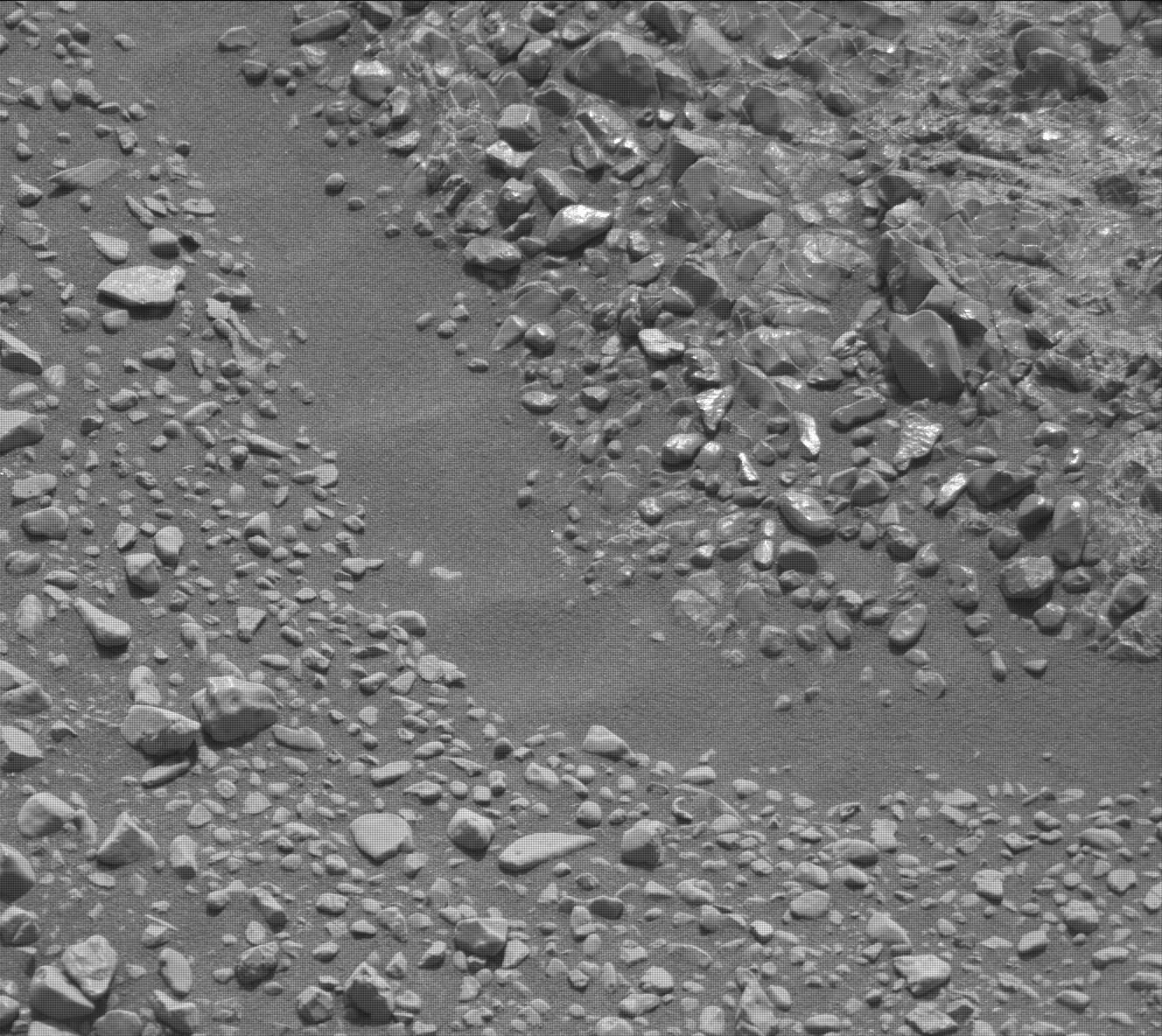
After all of these activities, we will make a short drive descending Knockfarril Hill on Sol 2309, while performing the second part of mobility tests to assess how to best drive in this new rubbly terrain. We close out our plan with a suite of atmospheric observations on Sol 2310, including Mastcam taus and dust devil surveys. I kept quite busy as the Geology Keeper of the Plan today, but it was well worth it to plan all of these exciting observations!Sols 2311-2312 update by Roger Wiens: Targeting Small Bedrock Patches, Pebbles, and Soil
The accompanying image shows the target "Brent" in the lower right corner; it was analyzed with ChemCam and APXS, and imaged with MAHLI over the weekend. It is a rounded pebble roughly an inch (2.5 cm) in diameter. In spite of the fact that it has been rounded by mechanical abrasion, it still shows faint layering. You can also see inclusions that are partially filled with brighter material. Marching vertically across the face of the pebble are five laser pits from ChemCam. The bottom of each pit has a telltale whitish appearance.
Over the weekend Curiosity completed a 20-meter drive. Curiosity is heading east and will be driving below the upper side of Vera Rubin Ridge, toward waypoint 2. One of the goals for this portion of the traverse is to image the rock layers along its upper slope, but so far the slope appears to be mostly covered with soil. Today's plan includes observations of what appears to be small bedrock targets, with Mastcam, APXS, ChemCam, and MAHLI observations of target "Isbister," ChemCam RMI-only observation of "Magnus," and Mastcam observation of the ChemCam AEGIS target from the weekend. Mastcam will also image "Knockfarril Hill," "Crawton," and "Elgol." Following a planned 44 meter drive and post-drive imaging, MARDI will get a view of the pebbly surface in the new location, and RAD, DAN, and REMS will take data. On the second sol there is a 360 degree Mastcam mosaic and Navcam horizon and dust-devil surveys. The plan also includes a number of engineering checks, including one on the current thermal environment.
Protect Our Shared Future
You help us defend humanity and prevent asteroid impacts. Donate now to become a Planetary Defender!
Donate