
 Explore Worlds
 Find Life
 Defend Earth


Curiosity update, sols 1814-1926: Vera Rubin Ridge Walkabout
Written by
Emily Lakdawalla
January 6, 2018
My apologies for the long delay between updates. When I last left the rover back in September, it had just climbed onto Vera Rubin Ridge. Since then, it has slowly maneuvered southish atop the ridge, encountering colorful rocks. Progress has occasionally been interrupted by various issues (uplink failures, arm faults, short drives, et cetera) that led some team members to joke that the ridge may be cursed. Nevertheless, the rover has driven about 600 meters, delivered multiple Ogunquit Beach samples to SAM and one to CheMin, and even run its first (intentional) wet chemistry experiment.
The rover still cannot use its drill to acquire rock samples, but there is a nonzero possibility that by the next time I update you on the mission, we'll be able to celebrate a return to drilling activity. In the meantime, Curiosity is exploring some fascinating relationships among distinctly different rock layers at the ridge top. As usual, I'm very grateful to project scientist Ashwin Vasavada for taking the time to answer my questions about what the rover has been up to lately.
Let's begin by getting oriented. Here is the latest version of the past-and-future traverse map from the beginning of the mission to now. You can see how Vera Rubin Ridge is a narrow, pretty straight feature. For the period covered by this update, the rover has been driving across the ridge, more or less perpendicular to it. You can also see that before they exit the ridge, they plan a substantial eastward jaunt. I'll explain why in a minute.

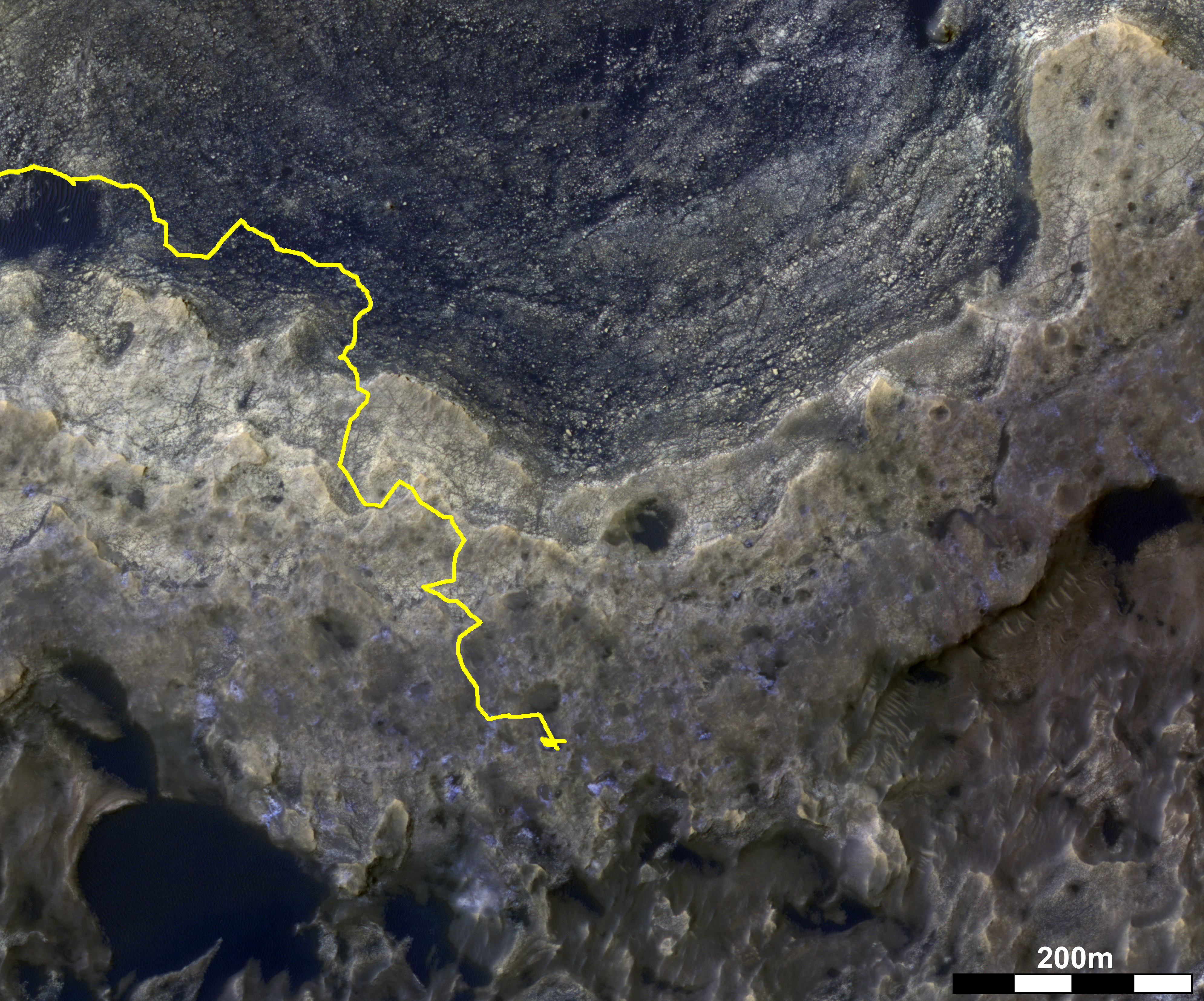
Now, to zoom in. I made a Frankenstein map out of two of Phil Stooke's route maps to cover the part of Vera Rubin Ridge that Curiosity has traversed so far. If you are curious about the variety of place names on these quads, I have some information about that at the very end of this post.

Phil uses black-and-white images from the HiRISE camera on Mars Reconnaissance Orbiter as his base maps, and usually that's sufficient. But Curiosity has reached terrain that looks colorfully interesting from orbit, and to appreciate that I'm going to need to show you maps using two other kind of base image data. The first is HiRISE color. The ordinary black-and-white HiRISE images are photos taken in red wavelengths. HiRISE acquires a skinny swath of color data at the center of every image that adds in two other color channels, "blue" (taken in blue-green wavelengths) and infrared. When you combine those with the red-filter data in a color composite, you can sometimes see different rocks show up as different colors. (If you see no color variation, that usually indicates dust covering.)
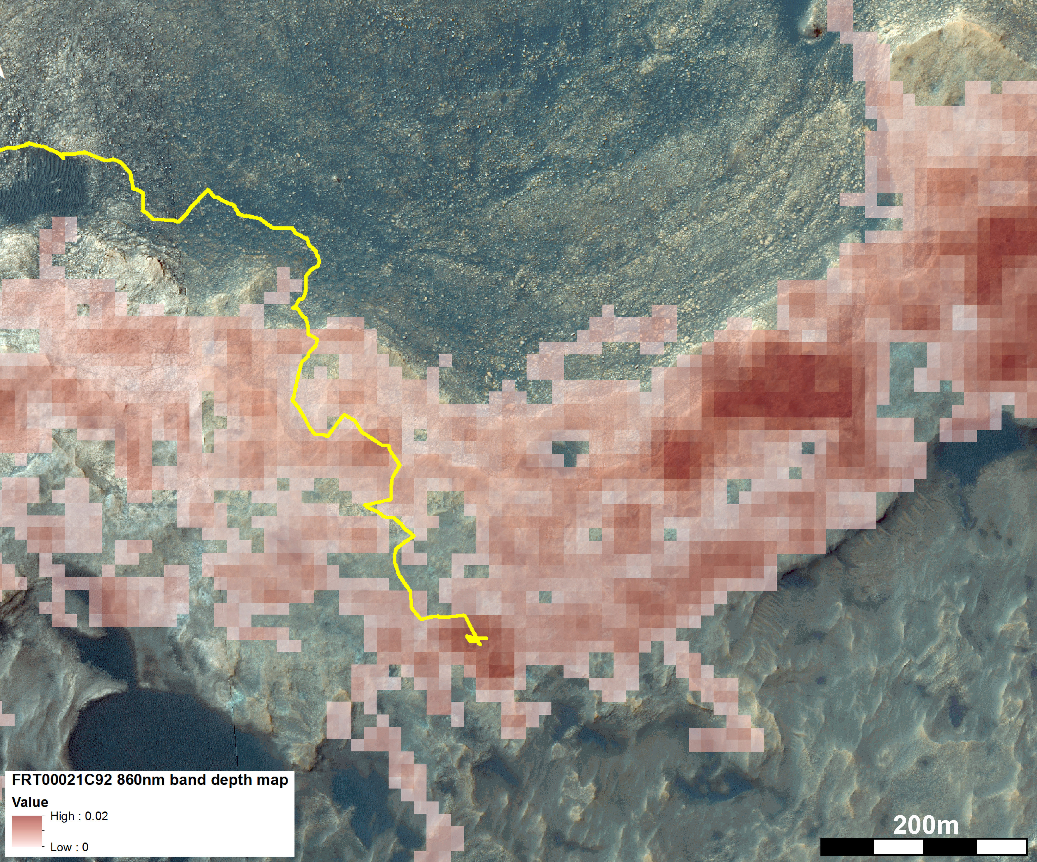
The second additional piece of data comes from CRISM, the imaging spectrometer on Mars Reconnaissance Orbiter. Spectroscopists can process CRISM data to produce maps of areas where a dip in a spectrum indicates the presence of a specific mineral or class of minerals. For Vera Rubin Ridge, which was until recently known as hematite ridge, the parameter of interest is a dip in the spectrum that can indicate the presence of the mineral hematite. In the map below, I've overlaid the HiRISE color and the hematite parameter map along with a line indicating Curiosity's recent traverse. Curiosity's travels across the ridge are headed to places with a strong hematite signal and interesting color variations in HiRISE.


The HiRISE image is ESP_042682_1755. Click here for an enlargement.
The CRISM map shows the strength of the 860 nm absorption seen by CRISM, which is diagnostic of the mineral hematite. Click here for an enlargement. Brighter reds correspond to deeper absorption. This parameter map was processed to 12 m/pixel using an along-track over-sampled CRISM image, FRT00021C92. Curiosity also observed hematite all along its traverse in the Murray formation leading up to the ridge, but these detections were more difficult to see from orbit due to sub-pixel mixing with sand and dust in the rocks below the ridge. CRISM data processing courtesy Valerie Fox and Raymond Arvidson, Washington University in St. Louis.Image: NASA / JPL / UA / JHUAPL / CRISM map courtesy Valerie Fox, Ray Arvidson, and Abigail Fraeman
A couple of things I notice in the comparison: When you look at the HiRISE image, there are three distinct terraces making up Vera Rubin Ridge. The northern two (which are lower in elevation) look yellowish in the shifted-color image above, while the southernmost terrace (which is highest-elevation) has distinctive little blue patches in it. In ordinary visible light, the northern terraces are redder, and the southern one is grayer or bluer. And yet when you look at the CRISM hematite map, there's no obvious correlation between hematite band depth and location on the different Vera Rubin Ridge terraces. That being said, Curiosity is presently in a location where there's a reasonably strong hematite signal, on top of a blue-gray patch.
Finally, I want to zoom a little closer into the HiRISE color along Curiosity's traverse. This is another of Phil's maps, except I've taken the liberty of swapping in the HiRISE color. Note all those interesting little blue-gray patches. They appear mostly on the southernmost part of the ridge.

Phew. Are you oriented yet? Let's check out what Curiosity saw and did.
Purple rocks and pretty views
For the first part of the traverse -- covering the lower (northern) two of the Vera Rubin Ridge terraces, up to sol 1877 -- the rocks mostly look similar to Murray mudstones. They are very, very finely laminated, like this example from early in the traverse.

There were hints of color variations from place to place, but whenever Curiosity brushes rocks, it appears as though the color variations mostly have to do with variations in dust cover. With the dust removed, the rocks were distinctly reddish, even purplish. Pretty much everywhere Curiosity brushed, that color showed through. Here are a few more examples from sol 1822, 1837, 1864, 1870, and 1885. While I'm mentioning interesting-looking rocks, I would also like to pause to appreciate the nearly-levitating plates of wind-eroded rock that all Gale topographic highs seem to possess. It's amazing what shapes wind can carve when there is zero water around to ruin the wind's fun.
These couple of months of traverse across the lower terraces of the ridge were rich in science data acquisition but a little monotonous. I had considered writing an update before Thanksgiving, but there wasn't much to say, especially because annoying operational hiccups kept interrupting progress. At one point, Curiosity was stuck for two weeks. At least the higher elevations of the ridge made the view from the parking spot a good one.

And here's a look in the other direction, to the southwest, toward the foothills of Mount Sharp. Curiosity is not driving toward the mountain in this direction, for obvious reasons. It will scoot a bit to the east to find some gentler topography.

The drive on sol 1877 took them to a parking spot for the Thanksgiving holiday, where they remained until sol 1887. Beyond that, the rover drove onto the topmost terrace of Vera Rubin Ridge, onto an area that had been enticing the team's attention for some time. From orbit, it had especially colorful rocks, with the appearance of gray-blue windows being eroded into hollows in surrounding red-purple rocks. (On the shifted-color HiRISE composites above, the blue windows are eroded into hollows in yellow rocks.) The rover bumped up and down among purple and gray rocks until sol 1901 when it reached a particularly orbitally interesting spot. The spot is notably blue-gray in the color-shifted HiRISE images, with a relatively strong CRISM hematite signal, though not the strongest along the ridge. They had the rover do a quick survey and then drove away on sol 1905. But after the weekend, the team decided that what they'd seen merited turning back around.
What did they see? Here's a survey of the location from the Mastcam's higher-resolution right eye, in Gigapan format. Looking at it from this distance, you can get a general impression of yellower rocks closer to the rover and lower in elevation, surrounded by redder rocks above. Up close, there is fascinating color variety, and some really cool-looking stick-shaped features in the rocks. To my eye, they look like mineral crystals that could've grown within the rock at a time when it was soaking in mineral-rich groundwater, or maybe such crystals that dissolved away, leaving vugs that were later filled with other stuff. Whatever they are, they're more resistant to erosion than the rock material they formed in, so they're now protruding from the rock. I am very much looking forward to finding out what the ChemCam and APXS instruments tell us about these things.

The science team seems to be excited about this site, so they may be here for a little while. After wrapping up here, they will head eastward to a nearby location that has an especially strong hematite signal as seen from orbit. The views should remain awesome for some time to come, as long as the rover stays on the ridge.

The (brief) Curse of Vera Rubin Ridge and the success of wet chemistry
The operational hiccups that I keep mentioning included failed uplinks (in which a problem at a Deep Space Network station causes Curiosity to receive no instructions), wheels getting stuck on rocks, unfortunately timed downlinks that limited rover driver visibility of the landscape, and even an Internet outage affecting the San Diego-based camera team's communication with JPL. Then there was a farcical sequence of events that happened while the Curiosity team was trying to do what should have been a moderately ordinary activty (though still tricky, because it's on Mars, after all): deliver a sample into the SAM instrument. It should've been a routine repeat of an experiment last performed on sol 1652, using the Ogunquit Beach sand sample that has been held in the turret ever since. This one activity failed on three separate occasions (sols 1839-1840, 1854, and 1858) for three different reasons (a SAM command error, one lost uplink, and finally a thermal fault in the arm because it's winter and it's cold). Not one of these operational hiccups was a serious problem, but together they made for a maddening period. They finally succeeded in performing the SAM experiment on sol 1862, after which the "curse" lifted. Since then, there have been three flawless SAM experiments.
The most recent SAM experiment on Ogunquit Beach, conducted on sol 1909, represents a major milestone for the mission. It was the first time that the SAM team has deliberately punctured a cup of solvent in order to dump sample in and perform something called a derivatization experiment. The goal of SAM's derivatization experiment is to try to detect large organic molecules. (As a reminder, organic molecules are carbon-containing compounds. They range in size from very small molecules like methanol to gigantic polycyclic aromatic hydrocarbons.) SAM has produced a lot of science, but has only detected small organic molecules. Either there are only small organic molecules present, or larger molecules are combusting (being broken up into smaller ones) because of the high heat of the SAM oven before SAM gets a chance to measure them. In the derivatization experiment, a compound called MTBSTFA is able to react with large molecules to turn them into ones that are gaseous at lower temperatures, so they are liberated to go into SAM and get measured by the gas chromatograph mass spectrometer without combusting.
The MTBSTFA in SAM has caused a lot of problems in the past because one of the sample cups leaked before landing, contaminating the interior of SAM. The team has had to do a lot of work to limit the effects of the MTBSTFA contamination, but they seem to now have a handle on how to handle the issue. Until now, SAM has only performed dry experiments, in which it heats up solid samples to drive off gases and measure the gas composition. Sometimes, they have allowed samples to sit inside SAM and react with the MTBSTFA contaminant for a long time, something they call opportunistic derivatization, but they haven't punctured any new cups in the past. The mission has been reluctant to puncture a cup because of the low but nonzero risk that it could cause more contamination of future SAM experiments. However, we're almost 2000 sols into the mission, and the mission agreed it was time to try this capability.
Ever since I heard that they did the derivatization experiment on the Ogunquit Beach sample, I had questions. Ogunquit Beach is a modern windblown sand from an actually active sand dune, whose grains have been exposed to UV radiation and the intensely oxidizing environment of modern Mars. It was not clear to me why anybody would be looking for large organic molecules in it -- except that Curiosity currently (and hopefully temporarily) has no capability to acquire new samples. Was it only an opportunistic experiment or did they actually expect to see anything? Ashwin confirmed to me that Ogunquit Beach would probably not have been the SAM team's first choice for a wet chemistry experiment, but the timing was right and the SAM team figured that, at worst, it could serve as a sort of blank or baseline experiment to which (hopefully) future drilled samples could be compared. What did they find? Ashwin appropriately wouldn't tell me anything specific, but he did say the experiment was successful, and that they saw things in the Ogunquit Beach sample that they hadn't seen in the previous, dry evolved-gas experiments. Stay tuned for science, possibly as early as the Lunar and Planetary Science Conference meeting in March, if the SAM team can figure out what their instrument is telling them by then.
Drill Update
Ashwin told me that the team had made significant progress toward resuming drilling. (You may want to review my detailed summary of the drill problem for an explainer on feed-extended sample transfer and feed-extended drilling.) There have been two major prongs to the effort. The first was to develop and characterize feed-extended sample transfer on the testbed rover, making sure that it is workable to reverse-auger drilled sample from the drill bit into the SAM and CheMin instruments. The Earth-based part of that work is completed -- testing's been done, software written and verified, and the mission has completed reviews, in anticipation of it being tested out on Mars. The main problem with feed-extended sample transfer is that knowledge of the amount of material transferred to CheMin and SAM will be less precise than it was previously. CheMin doesn't care as much about this as SAM does, as long as a minimum quantity of material gets into the instrument. Some SAM experiments (like evolved gas analysis) are less sensitive to delivered sample volume, but others, especially geochronology, are much more sensitive.
The other effort has been developing feed-extended drilling. A problem is that the arm force-torque sensor on the testbed rover was not operating up to specification. This has never been an issue until now, but now that the rover is going to be using arm motion to drill, it has suddenly become extremely important to measure the forces and torques on the arm coming from the drill bit, to enable the rover to guard against the bit assembly binding in the rock as the rover pulls out the drill. It took a while to get the sensor ordered, installed, tested, and calibrated on the testbed rover and compared with the one on Mars, but they're done now and are steadily moving through the process necessary to get going on Mars. The rover could drill as early as February, potentially, but there are a lot of variables involved (including finding appropriate targets and avoiding Martian gremlins). It'll happen when it happens, but there appears to be confidence that a return to drilling will happen, so that's very good news.

Meanwhile, there is one other issue they've been working on Mars. When the drill feed started showing signs of problems, the team inventoried the other similar motors on the rover and ran tests on Mars to see if any of them was showing similar issues. The tests turned up similar intermittent balky behavior in one other motor, the drill chuck motor. This motor had not been used at all since being tested shortly after landing. Its sole function is to replace a drill bit, dropping the installed one and attaching one of the two stored in the bit boxes on the front of the rover. The mission had planned for drill bit replacement being needed in two main scenarios: if the initially installed bit wore out, or if the bit got stuck in a rock. Since landing, the drill bit that's currently being used has shown almost no wear as it's drilled into soft rocks, so the mission is no longer concerned about needing to replace a dull bit. Unfortunately, the failure of the drill feed mechanism has made the scenario of a drill bit getting stuck in rock slightly more likely. But it is still not very likely. Still, since leaving a bit in the rock is the action of absolute last resort, the mission wanted to make sure they could still rely on that last-resort option. The team's been running diagnostics on the drill chuck mechanism and it looks like it works sufficiently well to remain viable as the last resort option for relieving a stuck drill bit. (Basically: it's balky, but if it doesn't work the first time they try to use it, it can be coaxed to work on subsequent attempts, and that's good enough.)

Quad-Hopping
I promised at the beginning of this post to talk about all the different place names on the recent route map. It's a confusing region in part because Curiosity has been quad-hopping, traveling in and out of three different quads. What are quads? Before the landing, the team divided the landing site into squares measuring 0.025 degrees on a side (about 1.5 kilometers), which they called quads. They assigned each quad a name honoring a well-known geologic locale on Earth. Then, as the rover has driven into each quad, the team uses place names associated with the Earth locations to informally name features and targets that Curiosity explores. The names are just an internal team vocabulary that helps them speak to each other about targeting observations, much better than other options like "target q23943-834" or "the top right side of the dark rock that's next to the big flat rock". Using the quad-and-locale system helps the team generate lists of target names that have been through a filtering process that has already deemed them safe for public discourse -- if they're safe enough for Earth maps, then they're good enough for Mars maps. It's also a fun way to add some international flavor to the mission.
When the rover drove onto Vera Rubin Ridge, it was in the Bar Harbor quadrangle, named for the location in Maine. The Bar Harbor quad features a mix of targets with English-language names (Pumpkin Nob, Tinker) and names that originated in the language of the indigenous Penobscots (Passadumkeag, Pennessewassee). I've seen a few scientists laugh and joke about these names being "weird" or "unpronounceable." That is, as the kids say, not a good look. First of all, they're not hard to pronounce if you sound them out carefully (take it from me, Emily Lakdawalla). If you can't pronounce them it means you don't consider it worth your time and effort to try, which is disrespectful. If you can figure out how to say "pachycephalosaurus" or "hypothyroidism" or "Laphroaig", you can say "Passadumkeag". Second of all, calling somebody else's name "weird" presumes a lot about what is normal and what is weird -- again, disrespectful. Think about who you are calling weird. And then don't do it.
Atop the ridge, Curiosity exited Bar Harbor and entered Kuruman on sol 1828. In a mission blog, Abigail Fraeman explained that Kuruman "is named after a charming town situated on the edge of the Kalahari desert in South Africa. Notably, the town of Kuruman is the namesake for the Kuruman Iron Formation, an approximately 2.46-billion-year-old sedimentary rock that is rich in hematite. Hematite is the same mineral we can see is distributed throughout the Vera Rubin Ridge from orbital data! The target names we will use while in this quadrangle are pulled from famous geological features from South Africa and nearby Botswana and Zimbabwe." Thus, names like Lebombo, Oaktree, and Klipfonteiheuwel.
But Curiosity only clipped the corner of the Kuruman quad, driving quickly into a new one, Torridon. Rachel Kronyak wrote that Torridon is named for "a village in the Northwest Highlands of Scotland that is near the Torridonian Supergroup, a geological formation that contains some of the oldest evidence of life of any rocks in the United Kingdom. We hope that this life-inspired Torridon quadrangle will give us good luck as we explore the ancient (and potentially habitable) environments along our trek up Mount Sharp!" Thus, recently, we have targets named Holyrood, Laphroaig, Coll, Yell, and Hoy. Phew.
After writing this post, and finishing it near 5pm on a Friday, I'm ready for a dram of Laphroaig myself! Raise a glass of whatever you're drinking -- be it coffee, tea, water, or whatever -- and toast Curiosity's health and prosperity in the coming year.
And now, if this blog entry wasn't long enough for you, here are 16,000 words' worth of official Curiosity mission blog updates covering the last four months. If you're wondering why I include these every time, it's primarily for book reasearch purposes -- it really helps me pin science targets in context and time.
Sols 1811-1814 update by Michael Battalio: Mars of Many Colors (12 Sep 2017)
Today was an exciting day of planning as Curiosity continued her ascent up Vera Rubin Ridge. The focus of the weekend plan was on carefully documenting the changes in stratigraphy as we leave the Murray bedrock. Fortunately, we are privy to a bevy of interesting targets and contrasting colors.
On the first sol of the plan, GEO concentrated on planning contact science with the rover arm and was eager to target purple (yes, not red, but purple) and tan facies of the exposed bedrock. As an atmospheric scientist, such an astounding set of contrasting tones catches even my attention. Many of the observations in the plan will be focused on determining the exact structure and composition of the purple rocks and how composition changes between purple and tan. "Sasanoa" is a tan, homogeneous target, and GEO planned MAHLI and APXS observations to assess grain size and composition. MAHLI and APXS will also target "Kemps Folly," which is a purple toned rock with fine banding. MAHLI alone will take a mosaic of "Mount Ephraim," which is a dark purple section of bedrock pictured in the bottom center of the above image, to assess sedimentary structures.
On the second sol (Sol 1812) ChemCam and Mastcam will complement the previous sol's contact science by observing both Sasanoa and Kemps Folly. ChemCam will then target the dark purple section of bedrock imaged by MAHLI, Mount Ephraim. Next, ChemCam will target "Mount Coe," which is a target that looks across the purple to tan colored bedrock contact to better characterize the composition in the transition between the bedrock tones. Mastcam will take stereo imaging of Mount Coe and "Two Brush Reef" to check for dips in the rock faces. Finally, Mastcam will image "Pettegrove Point" to further scout out Vera Rubin Ridge. After this, an approximately 5.5 m drive is planned to move further up Vera Rubin Ridge.
On the third sol (Sol 1813), the only GEO observation is an AEGIS automated ChemCam activity.
As ESTLK, my last day of operations consisted of planning an ENV morning imaging suite on the morning of Sol 1813, which will contain a Mastcam tau and LOS extinction measurement and two Navcam cloud movies, a supra-horizon movie and a zenith movie. Afternoon tau and LOS measurements will be repeated to check for diurnal variability in the amount of atmospheric dust. In addition, Navcam will make an LOS measurement for comparison to Mastcam values. REMS will fit in 24 extended, hour-long blocks, including four HRIM (High Resolution Interval Mode for humidity) measurements, and DAN will take the usual passive and post-drive active measurements.
Sol 1814 update by Rachel Kronyak: Spectacular views (12 Sep 2017)
As we've seen from the past several weeks and months of imaging, Curiosity's approach to and ascent of the Vera Rubin Ridge (VRR) has provided us with stunning views of the Mount Sharp terrain. Our parking spot after this weekend's drive was no exception, seen in the Navcam image above. In today's plan we are continuing our trek up the lower strata of the VRR and have no shortage of multi-colored bedrock targets to image and analyze.
Today we planned two sols. On Sol 1814, we planned a touch-and-go (APXS analysis + full suite of MAHLI images) on the dark bedrock target "Pumpkin Nob." Additional science block activities include a corresponding ChemCam raster and Mastcam image of Pumpkin Nob. We'll also perform a multispectral Mastcam observation on "Weymouth Point," a region of VRR terrain just ahead of Curiosity. Following a drive, we'll take our standard post-drive images and DAN active observation. On Sol 1815, we have a short mid-day science block, during which ENV will conduct a suprahorizon movie and dust devil survey. ENV also has its standard REMS observations.
Sol 1815 - 1816 update by Abigail Fraeman: Stopping to Smell the Rocks (14 Sep 2017)
Planning for Curiosity this morning was a bit like reading a great mystery novel. There were several twists and turns along the way, but we eventually reached an exciting ending that will reveal "Whodunnit?" - or more accurately -- what geologic forces had done to shape this landscape billions of years ago.
The drive yestersol was successful, and placed us in front of one of many meter-scale factures that criss-cross this area. These fractures are visible in high-resolution orbital images, and on the ground are surrounded by raised broken rocks that appear to be slightly more resistant to erosion than their surroundings. We are interested in understanding how these fractures formed, if they were conduits for ancient water, and why the rocks on their edges are raised. We made a quick decision early in the planning day that these rocks were interesting enough to warrant staying here another couple of days to collect good contact science targets, rather than the single touch-and-go we had originally planned.
Once we decided to stay, the geology theme group had to work quickly to figure out what targets would be best to collect MAHLI and APXS data from. This entailed a lot of back and forth between the scientists and rover planners to understand which targets were reachable in the somewhat broken up workspace in front of us, and which were simply too far away or fragmented to access. After some work, we were able to find a great raised rock to examine with APXS and MAHLI, and we named the target "Schoppee." We'll also be taking 25 cm MAHLI standoff images of several other locations near the raised rim of the fracture to give us additional information about targets we could study in the weekend plan.
Forgoing the drive also allowed us to have time for some morning remote sensing before the contact science. During this time, we'll be taking ChemCam observations of targets "Elwell," "Bragdon," and "Graffam," as well as corresponding Mastcam documentation imaging. We have more remote sensing planned on the second sol, including a ChemCam RMI Z-stack observation (used to make a 3D model) of fine laminations in the target "Phoney Island," a corresponding Mastcam observation, and many environmental measurements in the afternoon and early morning.
Sol 1818-1819 update by Ken Herkenhoff: Brushfest (16 Sep 2017)
We are planning only 2 sols today because there will be a soliday on Sunday to get us back in sync with "Mars time" in Gale Crater. The focus of science planning this morning was on observations of the current workspace, including an experiment to acquire APXS and MAHLI data on a bedrock target before and after brushing. MAHLI images of three potential DRT targets were received and used to determine which of these small exposures could be brushed. One had small pebbles in the DRT ellipse, so could not be brushed, but both of the other targets ("Christmas Cove" and "Mitten Ledge") are brushable. So the APXS will measure the chemistry of Christmas Cove before it is brushed off, then will be placed on the brushed spot to measure chemical differences. MAHLI will image both targets before and after brushing, then acquire a full suite of images on a layered block dubbed "Whittum." Also on Sol 1818, ChemCam will shoot its laser at another layered bedrock block named "Medomak." Mastcam will also image Medomak, the Sun, and the crater rim to measure dust opacity in the atmosphere. That night, the APXS will be placed on Mitten Ledge for a long integration.
On Sol 1819, Navcam will search for dust devils before ChemCam acquires passive spectra of Christmas Cove and Mitten Ledge. Mastcam will then acquire multispectral observations of Christmas Cove and more distant "Jaquish Ledge" before the rover drives away. After the drive, in addition to the standard imaging, DAN will execute two active integrations. Because the Martian winter is approaching, we are planning more heating, which reduces the power available for other activities. Therefore, it was difficult to fit all of the above into the plan today, making for a challenging day for me as SOWG Chair. We had to shorten or delete some scientific observations, which was painful, but I'm happy with all of the science we were able to plan today!
Sol 1820 update by Michelle Minitti: What lay beneath (19 Sep 2017)
Curiosity's weekend "Brushfest" paid off, revealing the stunning purple color of the rocks of this part of the Vera Rubin Ridge (VRR) hiding below the veneer of dust on their surfaces. As Curiosity arrived at her new bedrock-rich workspace after a weekend drive of ~18 m, the science team had to decide whether to quickly interrogate a contact science target with MAHLI and APXS using a touch and go, or stay and find out what lay beneath the dust. There were hints around the workspace that color variations were present, with surfaces visible in shades of tan, gray and purple, so the science team decided to push the drive off a day and stay to use the Dust Removal Tool (DRT) once again on the VRR rocks in the workspace.
The science team was not only in a cleaning mood, they were in a tongue twisting mood, as evidenced by the names of the two MAHLI and APXS targets, "Passadumkeag" (a small Maine town) and "Pennessewassee" (a lake near Norway, Maine). Passadumkeag, a tan-colored target, will benefit from the DRT's revelatory powers, while Pennessewassee, a more gray-colored target, will be interrogated as is. ChemCam will shoot Passadumkeag, adding to the chemical data from that target, as well as "Uncle Zeke Island" and "Mustards Island." The Uncle Zeke Island raster will cover an area of bedrock where its color changes from bluish to purplish. Mustards Island is a unique, non-bedrock target unto itself - a gray, lumpy disc of rock resting loose in the workspace. Mastcam will also acquire multispectral data from Mustards Island to help constrain its unique appearance.
Despite the focus on rocks today, the environment of Gale still got a bit of attention, with regular REMS and RAD measurements and a 360 degree Navcam panorama looking for dust devils. If only we could get those dust devils to do a little dust removing for us on our path ahead!
Sol 1821 update by Roger Wiens: Heading for Half a Million Laser Shots (19 Sep 2017)
Communication ties our lives together. If phone or internet service goes out in our area, sometimes we have to put our lives on hold for a few minutes or a few hours. The same is true for Mars operations. Yestersol Curiosity missed its 'phone call' from Earth due to a small issue at one of NASA's Deep Space Network stations. We were aware of the issue yesterday, but we went ahead and completed the operation plan in case something would change at the last minute, but no dice. So today we plan to uplink exactly the same plan. Yestersol's plan is described in the blog for Sol 1820.
Of special note, ChemCam's observations will carry it past the half million mark for the number of laser firings on Mars. We receive a spectrum with each laser pulse, so these all represent a huge amount of critical data on Mars compositions. Fortunately, ChemCam's laser should last a while longer. Based on ground testing, we hope for at least another half million shots.
In some of my public talks, I joke about the initial media reaction to shooting the laser on Mars. We tell reporters that the ChemCam instrument 'zaps' rocks on Mars. However, sometimes the media edit this to sound a bit more engaging, writing that the rover 'blasts' rocks on Mars. The latter word can have much bigger connotations, like an explosion. In fact, at the time of the landing, we found a doctored picture on the internet showing ChemCam's laser beam eliciting a large explosion on Mars, with a fireball and debris cloud. In many of my talks I show this picture, which always brings a good laugh.
In reality, ChemCam makes only very small pits in the rock, well under a millimeter across. The RMI image shows the pits made in some of the softer rock we encountered a week ago on target "Sasanoa". This image is only 5 cm (2 inches) across. Several years ago we used MAHLI to make a short video of the LIBS plasma on Mars (see video link).
When I think about these tiny traces that the rover leaves behind, I wonder if someday humans will follow the trail of this rover. Perhaps they will look for wheel marks, drill holes, and laser pits, a bit like we look for wagon-wheel ruts along the old Santa Fe Trail that brought 19th century settlers into the American West, or like we look for asphalt remnants of Route 66, the early- to mid-20th century highway from Chicago to Los Angeles.
Sol 1822 update by Lauren Edgar: Onward and upward! (21 Sep 2017)
On Sol 1821, Curiosity successfully completed contact science activities at "Pennessewassee" and "Passadumkeag". Perhaps in an effort to get to more easily pronounceable rock targets, today's tactical team planned a nice long drive towards our next waypoint on Vera Rubin Ridge.
The Sol 1822 plan begins with a Navcam movie to look for clouds above the northern rim of the crater. Then Curiosity will turn her attention towards the bedrock targets in front of her, using both Mastcam and ChemCam to assess the spectral character of yesterday's DRT target "Passadumkeag" and to assess the composition and sedimentary structures exposed at "Hypocrites Ledge." We'll also use Mastcam to monitor the movement of fines on the rover deck. Then Curiosity will gear up for a drive of ~40 m, as we work our way towards the next waypoint (located in the top center of the Mastcam image shown above). Downlink data volume was a challenge today, so the team had to think carefully about the priorities of post-drive imaging to prepare for possible touch-and-go contact science and other remote sensing in tomorrow's plan. The afternoon post-drive imaging block also contains some extended Navcam coverage for additional geologic context and targeting, as well as two Navcam observations to search for clouds and monitor the wind direction near the zenith. With drives like these, we're really reminded that we have a mountain-climbing robot on Mars!
Sol 1823 update by Mark Salvatore: "Will you come with me, sweet Reader?" (21 Sep 2017)
Curiosity continues her traverse across the lowermost portions of Vera Rubin Ridge, where she continues to investigate the interesting rock textures and colors ahead. Our current location is quite dusty, which motivated the science team to focus on a relatively quick characterization of the surrounding bedrock, which will allow the rover to drive away and continue making progress towards some of the other interesting locations within Vera Rubin Ridge. The upcoming plan involves a quick "touch-and-go" using the APXS and MAHLI instruments for the chemical and morphological investigation (respectively) of a flat piece of bedrock named "Sherwood Forest." After stowing her arm, Curiosity will then use Mastcam and ChemCam to analyze both "Sherwood Forest" and a dark-toned target named "Tableland." These targets are located just to the left of center in this front Hazcam image.
Before driving away, Curiosity will also create a high-resolution Mastcam mosaic of a region to the southwest of her current location. This region was identified from orbit as a potential region of interest, as it shows a relatively steep slope with some potentially interesting bedrock exposures. Ever since ascending onto Vera Rubin Ridge, Curiosity has been making progress towards this location to determine whether it is worth investigating from close-range. As it turns out, the region doesn't appear all that different from the parts of the ridge that Curiosity has already been exploring. So, instead of continuing the southwest drive towards this location, the team decided to blanket the area in high-resolution color imagery before turning to the east-southeast and towards another region of interest. Updating the rover's planned traverse path using both orbital and ground-based data is very common, and this decision by the science team highlights how collaborative discussions and the ability to adjust plans in real-time can both save time and maximize the scientific return of the mission.
The title of today's blog post is a quote from the beginning of the 1883 novel "The Merry Adventures of Robin Hood" by Howard Pyle. It's not every day that Curiosity roves around "Sherwood Forest!" The full quote reads "And now I lift the curtain that hangs between here and No-man's-land. Will you come with me, sweet Reader? I thank you. Give me your hand." I feel this quote is quite appropriate for us planetary scientists, who continually "lift the curtain" between our lives on Earth and our investigation of the Red Planet.
Sol 1824-1826 update by Scott Guzewich: Reality and Fantasy Collide (22 Sep 2017)
At times, it seems like fantasy that we have a nuclear-powered car exploring Mars and that I get to help that exploration, including today as the Science Operations Working Group Chair. But at other times, mundane reality creeps in to throw cold water on that. Such as happened yesterday when a network communications problem here on Earth resulted in yesterday's Sol 1823 plan not being uplinked to Curiosity. That resulted in Curiosity performing a "runout" sol when only basic activities are performed.
But we picked up right where we left off yesterday and created a packed list of science activities to keep Curiosity busy over the weekend. We recovered the lost science on targets "Sherwood_Forest" and "Tableland" (both of which are just above the first letters in "Curiosity" in this image: https://mars.nasa.gov/msl/multimedia/raw/?rawid=NLB_559245410EDR_F0660384NCAM00375M_&s=1822), which includes ChemCam and Mastcam examinations of both and contact science on "Sherwood_Forest". We added another fantasy-themed named target in "Troll_Valley" (just past the sandy spot above the Curiosity logo in that previous picture), which also will be examined by contact science with MAHLI and APXS and remotely by ChemCam and Mastcam. We also planned an extensive suite of environmental monitoring, including a ChemCam passive sky observation (where we use the ChemCam instrument without the laser to study atmospheric dust, ice, and gases) and Mastcam and Navcam images to determine the amount of dust in the atmosphere as well as search for clouds. We are entering the cloudy time of year on Mars and expect more clouds over the next several months.
Lastly, we scheduled the rover to drive to the third stop of our Vera Rubin Ridge science campaign. That stop is near the small, dark-toned ridge straight ahead in this image https://mars.nasa.gov/msl/multimedia/raw/?rawid=NLB_559245598EDR_F0660384NCAM00258M_&s=1822.
Sol 1827 update by Scott Guzewich: It's déjà vu all over again (25 Sep 2017)
Just when we thought we were going to leave this spot on Mars, we found ourselves stuck here for yet another sol. This time, a fault during one of our arm activities caused us to lose our plans for the past two sols (which would have included a drive to our next waypoint in the Vera Rubin Ridge science campaign) and we were in recovery mode again today. This picture of the arm's shadow on the ground was taken just before the fault. So today, we make our third attempt to complete our science activities at this stop, including ChemCam and Mastcam targets of nearby bedrock: "Sherwood Forest", "Tableland", and "Troll Valley". We were also able to plan a Mastcam image of a target named "Elf Woods" that was originally intended for the weekend plan, but had to be removed for power considerations. Following these science activities, Curiosity will drive approximately 10 m closer to our third stop on Vera Rubin Ridge.
Sol 1828 update by Michelle Minitti: Bye Bye Bar Harbor (27 Sep 2017)
Before landing, Curiosity's landing ellipse and the foothills of Mt. Sharp were divided up into quadrangles - squares ~1.5 km on a side - to give science team members reasonable amounts of terrain to work with during pre-landing geological mapping, and provide the source of the target names within that quadrangle. Quadrangles get their names from towns that are nearby and share names with notable regions of geological interest on Earth, and since Sol 1500, Curiosity has been traversing the "Bar Harbor" quadrangle. If today's drive goes as planned, we will leave the Bar Harbor quadrangle behind, so today's blog will honor the Maine heritage of our long-time home.
Curiosity spent her last sol in the Bar Harbor quadrangle "going right out straight" (working very hard). With ChemCam, she zapped "Hawk Mountain," a rock with "savage" (great) layering, and a "whole 'notha" (another) target, "Bonney Woods," moving from a white vein into the surrounding bedrock. Mastcam acquired a small stereo mosaic over an area where the bedding geometry appeared particularly well-exposed. This area was dubbed "Erickson Fields," though not for MSL's "wicked good" (great) project manager, Jim Erickson. The Kuruman quadrangle is just out Curiosity's "dooryard" (front door), so with today's 32 m drive, we CAN get there from here!
Sol 1829 update by Abigail Fraeman: Hello Kuruman! (27 Sep 2017)
As was predicted in yesterday's blog, we have officially left the "Bar Harbor" quadrangle and are now into the "Kuruman" quadrangle. This quadrangle is named after a charming town situated on the edge of the Kalahari desert in South Africa. Notably, the town of Kuruman is the namesake for the Kuruman Iron Formation, an ~2.46 billion year sedimentary rock that is rich in hematite. Hematite is the same mineral we can see is distributed throughout the Vera Rubin Ridge from orbital data! The target names we will use while in this quadrangle are pulled from famous geological features from South Africa and nearby Botswana and Zimbabwe.
During our first full sol in the Kuruman quad, we will be doing a touch-and-go. We will investigate target "Enon" with APXS, MAHLI, ChemCam, and Mastcam. We are also currently sitting in front of an erosion-resistant outcrop, "Mt. Hamden," which is providing us with a nice vertical exposure that we will image with Mastcam left and right eyes. Finally, we will take another Mastcam image of target "Noisy" before driving off to the northeast. The day will end with some environmental science monitoring observations including a Mastcam tau measurement to assess the dust content of the atmosphere, and some Navcam images looking towards the sky and crater rim.
Sol 1830 update by Michael Battalio: We've got the power (29 Sep 2017)
With apologies to Montgomery Scott, "we do not have the power...," but we will, as today was about keeping our state of charge up in preparation for possible CheMin activities in a near-future plan. Fortunately, that absolutely did not preclude a lot of terrific science and a drive.
Today was a touch-and-go sol. Contact science was planned on a dark-toned target named "Collingham" in the hopes that the darker color indicated either a different chemistry or reduced surface dust. APXS, MAHLI, ChemCam, and Mastcam will all cooperate on observing this target. Mastcam will continue the Vera Rubin Ridge imaging campaign by capturing a 13x1 mosaic of a prominent outcrop, named "Tra Tra," which is the large outcrop at the top left of the above Navcam image. (Mt. Sharp is to the right.) A stereo image will be taken to ascertain the geometry of the bedding. Curiosity then will drive about 11 meters towards the top of a nearby ridge. Post-drive Navcam imaging will be taken as well as an automated AEGIS imaging activity with ChemCam.
ENV accommodated the power-saving requirements of the plan by not performing any imaging and only including REMS and DAN activities. The normal cadence of REMS observations was also scaled back in such a way as to not degrade the ability to perform good science. ENV can ensure this flexibility by shuffling the placement of REMS extended blocks (EBs) from one sol to the next or dropping very low-priority EBs. (Note that EBs should not be confused with the top-of-the-hour 5-minute blocks that are always scheduled.) Though the EB observations themselves are not power intensive, the additional wake-up time to retrieve these data from REMS memory into rover memory so that they may be relayed to Earth (an activity appropriately called a REMS Get Data) can use considerable power if required at night, especially during the winter season. The number of these Get Datas in any given plan can be reduced by simply cutting back on the number of EBs. (For a typical cadence in a 1-sol plan, about three or four Get Datas are required.) ENV can reduce the impact of dropped EBs on science goals by deferring the dropped blocks to future plans. This adaptability can be achieved because the highest-priority EB cadence is designed to capture a full sol of environmental measurements every six sols-that is, there are four evenly spaced 1-hr blocks every sol that get pushed backward by one hour in the following sol. (I.e., Sol 1830 has blocks at 0300, 0900, 1500, and 2100, while Sol 1831 will have blocks at 0200, 0800, 1400, and 2000. And so on.) Capturing a full sol of environmental monitoring at a regular frequency is important to ensure that any localized atmospheric phenomena are not missed as Curiosity explores Gale Crater. Additional high-priority observations support other MSL experiments (e.g., during expected SAM drop-off or atmospheric intake times or Mastcam change detection experiments) and concurrent monitoring when THEMIS (Thermal Emission Imaging System) onboard Mars Odyssey or MCS (Mars Climate Sounder) onboard the Mars Reconnaissance Orbiter is observing Curiosity's location. These are impossible to postpone but occur at specific, pre-planned times. At medium priority are periodic HRIM (High Resolution Interval Mode for humidity)-or morning-EBs and a noon EB every sol that looks for pressure drops from small-scale vortices (like dust devils). At low-priority are migrating two-hour EBs to detect any meteorological changes that might last longer than the usual hour-long blocks. All of these EB observations are usually easy to fit in the plan because they do not require the rover to be awake; however, the accompanying Get Datas must occur when the rover is awake. If the timing of awake periods due to other activities, like a communications pass, does not line up with the required Get Datas, then low-priority blocks can be dropped altogether and/or high-priority blocks can be pushed to the following sols to reduce the number of requisite Get Datas in a plan. For example, in the Sol 1831 plan, the 0300 and the 0200 blocks will be captured. In this way, the number of Get Datas and the ENV power requirements in a given plan are reduced, and a full sol of observations can still be taken within the six-sol goal.
Sol 1831 update by Mark Salvatore: Quite a Diffracting Weekend! (30 Sep 2017)
The science team has been waiting quite a long time for this moment. Back in late March, nearly 180 Mars-days ago and when Curiosity was investigating the last stretches of the Bagnold Dunes before continuing towards Vera Rubin Ridge, Curiosity's scoop gathered a sample called "Ogunquit Beach." In order to quantitatively determine the mineral assemblage present in this sample of a sand dune, Curiosity would have to deliver the sample to the CheMin X-ray diffractometer instrument. However, because of the ongoing troubles with the arm's drill feed, Curiosity has been stuck with Ogunquit Beach in "storage" and unable to deliver the sample to CheMin - until this weekend! Tomorrow, at around 7:30am PDT, Curiosity will be given the "all clear" to deliver Ogunquit Beach to CheMin. Throughout the weekend, CheMin will analyze this sample, precisely measuring diffraction data for deriving its mineral assemblage, and will send the data back to Earth. The science team is very excited to be crossing this milestone, and we can't wait to compare Ogunquit Beach to the other measurements of the Bagnold Dunes acquired over the last few years.
In addition to this big achievement, Curiosity will also be investigating interesting science targets directly in front of her. The first task of the "weekend" on Mars will be to investigate three geologic targets of interest. First, the ChemCam laser system will be used to determine the chemistry of the targets "Katberg," "Normandien," and "Black Reef." Katberg is a relatively flat and benign piece of bedrock lying directly in front of the rover. Normandien is a bit further away from the rover, and is a darker rock sitting on top of the local bedrock, sand, and dust. Lastly, Black Reef is another darker rock (though slightly larger and more rounded than Normandien) that doesn't appear to be a piece of the local bedrock in the immediate rover surroundings. Following these measurements, Mastcam will document these three targets, as well as acquiring a few small mosaics of the local bedrock to the left and right of the rover and monitoring environmental conditions (e.g., atmospheric dust). The afternoon of this day is dedicated to delivering Ogunquit Beach to CheMin, with CheMin analyzing the sample overnight.
In the early Mars morning of the second day, Curiosity will make some additional atmospheric observations using Mastcam and Navcam. Later that afternoon, Curiosity's arm will swing into position, will brush away any dust or debris from the Katberg target, and will image Katberg with the high-resolution MAHLI camera. The APXS instrument will then be used to collect an overnight chemical analysis of Katberg. Midday on the third day, Curiosity will stow her arm and set off towards the east to continue making progress through Vera Rubin Ridge. After her drive, Curiosity will acquire some necessary post-drive images before returning them to Earth for the science team to analyze on Monday morning.
While most of this weekend's activities are fairly "normal" in the context of our recent scientific investigations, delivering Ogunquit Beach to CheMin marks an important milestone for utilizing this valuable rover asset. We hope that the results of these analyses will be just as valuable in our understanding of the mineral assemblages present in Martian sand dunes!
Sol 1834 update by Roger Wiens: Partial Success: Ogunquit Beach Sample Delivered to CheMin (2 Oct 2017)
Over the weekend Curiosity worked on a bold plan to drop off a sample in the inlet of the CheMin instrument. The sample, "Ogunquit Beach," is dune material that was collected at Stop 4 of the spring Bagnold Dune II campaign, collected starting on Sol 1651. The drop-off sequences included a vibration of CHIMRA, the sample processing hardware. These vibration activities were done to help move the loose sample material within CHIMRA, including into the portioning chamber. Because the use of vibration has been seen to affect the health of the drill, a test of the drill mechanisms also was performed. Vibration resulted in detectable changes to the mechanisms, so the rover automatically halted further use of the arm until further instructions from the ground were received. We see this drop-off as a good partial success, and a chance to learn more about the drill.
The team's operations today focused in part on returning the arm to normal operations. This includes approving the arm activities, doing some more drill diagnostics, performing some regular science activities, and then commanding a short drive. Following the results from Friday, we will be taking a second look at the float rock, "Normandien" (shown in the center of the Mastcam image), to be observed with ChemCam's spectrometers passively (no laser). Mastcam will be observing "Transvaal Extension" with a 3-image mosaic, and it will do some deck monitoring following the weekend sample drop-off. APXS and MAHLI will observe "Katberg," which was observed by ChemCam over the weekend. There will also be REMS and RAD activities, a DAN passive observation, and a Navcam dust devil movie.
After the drive, Navcam will do its usual imaging of the targetable region in front of the rover, Mastcam will continue a clast survey, MARDI will take an image of the region under the rover, and Navcam will take a 360 degree panorama.
Sol 1835 update by Roger Wiens: Limpopo, Ecca, and Lucknow (3 Oct 2017)
Curiosity's 13.8 meter drive yestersol brought the rover a few meters higher on Vera Rubin Ridge (VRR) to a bit of a plateau. From here we can see over to the clay-rich unit beyond the ridge, and we can see more of the debris fan of the outflow channel that descends from Mt. Sharp, as seen in the accompanying Navcam image.
Today, for Sol 1835, we planned to remain stationary to allow a maximum of contact observations. This will include APXS, MAHLI, and ChemCam observations of two targets: a purplish "Ecca" and a tan-colored "Lucknow." The DRT will be used on both targets; "Ecca" will have the longer overnight observation by APXS. Mastcam will use its right-side imager to document these two targets and will obtain mosaics on "Limpopo" and a region of the next stop of VRR. Mastcam will also take left and right multispectral images of Katburg, a target that was observed by other instruments yestersol. The plan also includes DAN passive, and REMS and RAD get-data.
Sol 1836-1837 update by Abigail Fraeman: Frankenplan (4 Oct 2017)
Unfortunately we weren't able to uplink yesterday's plan onto the rover because of a technical issue with the DSN, so we spent sol 1835 in run-out. Today we worked very hard to generate what we affectionately dubbed a "Frankenplan," which is defined as a plan in which one mashes elements that were already prepared (the contact science we had hoped to do on sol 1835) with new elements (a drive). We were able to pull this off because we were planning two sols today (1836-1837) instead of the one sol we planned yesterday.
We'll begin the plan on sol 1836 with a remote sensing block that has ChemCam LIBS observations of targets "Ecca" and "Lucknow." These are the same targets we had planned to do contact science on yesterday. We are also taking Mastcam mosaics of target "Limpopo" and a nice vertical exposure that we may visit in the future. We additionally managed to fit in a Mastcam tau observation and a Mastcam multispectral observation of an area named "Hotazel." We will use the multispectral observation to document the spectral properties of the terrain in front of us. After finishing the remote sensing science block, we will repeat that contact science we had planned yesterday, collecting MAHLI and APXS measurements on bedrock targets that we are going to DRT, Ecca and Lucknow. The purpose of these contact science measurements is to document the properties of the bedrock on this middle plateau on Vera Rubin Ridge. We will also squeeze in one more Mastcam tau measurement and a crater rim extinction image before the sun sets.
Our main activity on sol 1837 is a drive to the east to continue on our exploration of Vera Rubin Ridge. We will collect a Mastcam multispectral observation of the brushed targets Ecca and Lucknow before we drive away. Whew!
Sol 1838 update by Christopher Edwards: Planning on Limited Data (6 Oct 2017)
After a successful plan was carried out on the previous sols, in the decisional downlink we received limited imaging data with which to work today. Due to this not-yet received data, we developed our plan with the local workspace in mind and pushed some observations into the next plan. In the workspace, we planned for two ChemCam observations and associated Mastcam documentation images designed to continue the characterization of the chemical makeup of the "Vera Rubin Ridge" and the context of the hematite. Due to limited power for today's plan (thanks to some power-hungry SAM observations), that's just about all that made it in from a remote sensing perspective.
However, we did get a couple of MAHLI and APXS targets into the plan on the "Cheshire" and "Duitschland" targets to further augment the chemistry derived from the remote ChemCam observations. All of these observations are helping us to build up a detailed sedimentological and chemical stratigraphy for the Vera Rubin Ridge.
In this plan, SAM was the star of the show, though this activity didn't have anything to do with the Vera Rubin Ridge campaign. In this plan, Curiosity completed the sample drop-offs of the "Ogunquit Beach" sample back from the Bagnold Dunes campaign. As a part of this measurement suite, SAM will conduct an Evolved Gas Analysis (EGA) where the sample will be heated and some of the sample minerals will decompose or release their trapped water. This measurement allows us to effectively characterize the volatiles (e.g., SO2, CO2 and H2O) contained in the samples with the Gas Chromatograph Mass Spectrometer (GCMS). In the next plan, Curiosity will be at the same spot since the SAM measurements took so much power this weekend they prohibited a drive. In that plan, we'll be able to recapture some of the activities that were excluded from today's plan due to the limited imaging data that was downlinked. While Curiosity carries out these science measurements over the weekend, it'll have a pretty spectacular view as its parked right next to the edge of the Vera Rubin Ridge.
As it turns out, there's still plenty to do on Mars.
Sols 1841-1842 update by Mark Salvatore: Who ever said roving around Mars was easy?
When you take a step back and think about all of the things that must go right in order to perform scientific investigations on the surface of Mars, it's hard to believe that we EVER get things accomplished! It also means that seemingly minor issues can lead to significant delays and complications when it comes to developing science plans, commanding the rover, and gathering the collected data. Today was one of those instances when a seemingly minor issue here on Earth significantly influenced our abilities on Mars.
Earlier this morning, as the science team was assembling to select targets of interest and to populate our block of time dedicated to science with observations and analyses, our communications and ability to develop and send commands to the Jet Propulsion Laboratory was disrupted. Specifically, the communications and data transfer between JPL and the team that commands the majority of the high resolution cameras, including Mastcam, MAHLI, and MARDI, was disrupted. This often happens to me when I'm trying to watch my New York Mets play baseball, so I know just how frustrating it can be! Unfortunately, this also sometimes happens when critical data transfers and communications for rover planning must also take place. So, the science plan for the next two days must be adjusted to account for our inability to use Mastcam, MAHLI, and MARDI.
We are in our "restricted" planning mode this week, so today's science plan will cover two Mars days. Early tomorrow afternoon on Mars, Curiosity will analyze two targets in front of the rover, "Bokkeveld" and "Buffalo Spring," using the ChemCam active laser system to assess the chemistry of these two targets. Buffalo Spring has a nodular texture, not unlike some interesting targets observed on Vera Rubin Ridge over the last few weeks. Bokkeveld is a "typical" bedrock target, which will help us to understand just how different Buffalo Spring is relative to more typical basaltic targets. Later that afternoon, Curiosity will undergo some additional drill diagnostics to assess all of the great work that the engineers have been doing to get the drill capabilities back to the science team.
Early the following morning, the Navcam cameras will be used to identify and monitor local clouds. Around midday, ChemCam will make an automated measurement of a nearby rocky target as well as its titanium calibration target, and the Navcam cameras will image the surroundings and search for local dust devils. That evening, CheMin will be programmed to perform a second analysis on the Ogunquit Beach sediment sample and retrieve the data the following day.
As you can see, there is no drive scheduled during this two-day plan, so the science team will have the same view on Wednesday as they do today. Hopefully on Wednesday, we will be able to utilize all of the imaging capabilities of the rover, finish analyzing the local surroundings, and continue to make forward progress towards the top of Vera Rubin Ridge!
Sol 1845-1847 update by Michelle Minitti: Game of inches (13 Oct 2017)
There's a line in the halftime scene of the movie "Any Given Sunday": "life's this game of inches…the margin for error is so small." The same is true on Mars. On Sol 1843, Curiosity started her drive with a turn to the right. Her right rear wheel encountered a small ridge (part of which is visible to the right of the wheel in the above image), a few inches of rock offering just enough resistance to cause Curiosity to stop the drive and wait for further instructions. The unexpected obstacle gave Curiosity a fourth planning sol at this location which the team used to add to their collection of bedrock measurements from the workspace. The "Bulawayo" target offered one of the least-dusty surfaces in the workspace, a gray, finely-layered and vertical rock face that made a tempting target for ChemCam. ChemCam also shot "Bushveld," a wind-sculpted expanse of bedrock dotted with small, resistant features. Not far from Bushveld, and adjacent to Sol 1838's "Duitschland" target, both MAHLI and APXS studied bedrock target "Stormberg." Having APXS analyses from both Stormberg and Duitschland in close proximity provides the opportunity to tease out small chemical differences between the targets.
After freeing herself from the obstacle by the right rear wheel, Curiosity will drive ~20 m farther up the "Vera Rubin Ridge." Post-drive, she'll acquire an automatically-targeted ChemCam analysis and a third CheMin integration of the "Ogunquit Beach" sand sample. Each CheMin integration brings the mineralogy of the Ogunquit Beach sample into sharper and sharper focus. The majority of the environmental monitoring observations also happen post-drive, including acquisition of mid-afternoon dust devil and cloud movies and a DAN active measurement.
Here's hoping the inches break our way this weekend!
Sol 1843-1844 update by Scott Guzewich: Winter is Coming (16 Oct 2017)
The seasons on Mars are long, and even though Curiosity is near the equator, the change in weather between the seasons is noticeable and winter is coming to Gale Crater. Right now it's late fall in the southern hemisphere on Mars and the colder weather changes how we operate Curiosity. In colder weather, we need more power to heat the instruments and keep Curosity's electronics and mechanisms warm. This reduces the amount of electricity we have to conduct science, but we were still able to prepare a full plan for the next two sols.
We identified two new bedrock targets to analyze with ChemCam ("Woodlands" and "Montecristo", which are near the bottom portion of this image). For Sol 1843, we also planned a series of Mastcam images of nearby bedrock targets that were analyzed with ChemCam as well as interesting spots in the distance, including a layered ledge on the Vera Rubin Ridge and a possibly hematite-rich patch called "Iron Mask" which we may drive near in the future. We also will drive approximately 22 m towards our next target on Sol 1843.
For Sol 1844, we planned an expansive series of environmental monitoring activities. As we approach winter, the Martian atmosphere gets cloudier and we planned a series of Navcam movies to search for clouds as well as a triplet of Mastcam images to determine the amount of dust and ice in the atmosphere and how it varies over the day. We additionally planned two Navcam movies to search for dust devils.
Sols 1848-1849 update by Lauren Edgar: How far we've come (17 Oct 2017)
Today felt like any other planning day: a straightforward plan involving remote sensing, a drive, post-drive imaging, and some untargeted observations on the second sol. Just a typical day in the office. Maybe even an easy one. It wasn't until I sat down to write this blog that I fully processed how far we've come and just how awesome Curiosity's "office" is. I was looking through the drive imagery and came across this Navcam frame (posted above), which looks down on the Murray Buttes and Bagnold Dune Field, across Aeolis Palus and the northern rim of Gale crater. It's pretty spectacular to see just how much we've explored in 5 years. But that was just a quick glance over Curiosity's shoulder (or the RTG, which hangs off the back of the rover), because our sights were mostly set on the terrain ahead of us to choose where to go next.
I was the Geology Science Theme Lead today, and it felt like any other planning day. We came in to assess how the weekend activities completed, what targets we had in front of us, and which route we wanted to take to get to the next interesting feature on Vera Rubin Ridge. The two-sol plan begins with a preload test of the rover's drill. Then Curiosity will acquire ChemCam and Mastcam observations of some nodular purple bedrock (target "Buck Reef"), and a unique gray-white vein or clast (target "Boomplaas"). We also planned some Mastcam imaging of sedimentary structures exposed in cross-section (target "Eccles") and to document the previously-acquired ChemCam AEGIS target. Then Curiosity will drive ~15-20 m further south to investigate some mottled outcrop that we first noticed from orbit. After the drive, we'll take Mastcam and Navcam images to prepare for contact science in the next plan. Data volume was a challenge today, so we had to think carefully about which images we need to have down in time to make decisions on Wednesday. On the second sol, Curiosity will wake up early to acquire a number of environmental monitoring observations to monitor clouds, dust, and wind. Later on the second sol we planned another ChemCam AEGIS observation to automatically target bedrock in our new location. Not bad for a typical day in the office!
Sol 1850-1851 update by Mark Salvatore: A Change of Scenery (18 Oct 2017)
Since the start of our investigation of the Vera Rubin Ridge (VRR, a narrow and winding ridge that exhibits signs of oxidized iron phases from orbit), we've been primarily driving around on fractured bedrock material with a general lack of sand. This is unlike the landscape in the Murray formation at the base of the ridge, which was dominated by a combination of bedrock exposures and wind-mobilized sands. However, following Curiosity's drive two days ago, the team found a local landscape dominated by small cobbles and pebbles with an abundance of fine soil surrounding these fragments. We had planned to investigate this location based on both ground- and satellite-based observations due to its different appearance relative to the rest of VRR, but this was our first up-close glimpse of this different landscape.
The science team had a few decisions to make during today's planning session. There was time available to use the MAHLI (high-resolution imaging) and APXS (bulk chemistry) instruments located on Curiosity's arm to investigate the surroundings, and the team was able to choose to perform either a quick "touch and go" analysis (where we are able to drive away the same day as making the measurements) or a more detailed contact science investigation, where APXS would be used overnight and we would stay in the same location for a few days. Each option has pros and cons (including the number of targets that could be analyzed, the amount of driving that we can do in the near future, etc.), so the team started the day with this detailed discussion of these options and the geologic targets in front of us.
With such a heterogeneous landscape in front of us, there was a concern that APXS measurements (which have a large footprint relative to the pebbles in the workspace) would be difficult to interpret (i.e., determining which pebble(s) or soil are contributing to the chemical signatures), so the team decided to forgo any APXS measurements and instead use the finer-scale ChemCam chemistry measurements to characterize the observed heterogeneity. Curiosity will also analyze the landscape using multispectral Mastcam observations, which can provide additional information about the observed compositional diversity. This will allow the rover to drive off later that same day without the need to stick around. Once this decision was made, the science team then took to selecting targets of interest to analyze.
ChemCam will analyze two locations near the rover to determine the compositional variability. The first target, "Blinkberg," is a pebble-rich region near the rover, and ChemCam will be used to measure several pebbles and soil patches surrounding this target. Investigation of the second target, "Wolkberg," will consist of measuring a larger clast and the surrounding soils. These observations will hopefully inform the team about any compositional variability observed in the pebbles that are strewn about the region.
Mastcam will then take over to acquire high-resolution imaging and multispectral observations. Mastcam will first turn to imaging the horizon just south of the rover, towards a region of interest for studying the nature and structure of the VRR. Next, Mastcam will image the "Blinkberg" ChemCam target and the surrounding area using all of its multispectral filters, which will help to characterize any observed compositional variations. Then, Mastcam will perform a similar observation of the "Wolkberg" ChemCam target and the surrounding region known as "Zeederberg." Curiosity's arm will then be unfurled, and she will use the MAHLI high-resolution imager to investigate the "Blinkberg" target, hopefully helping to constrain the grain size of the pebbles and sediments in the acquired scenes.
After this region has been extensively studied, Curiosity will continue her drive towards the south. Following this drive, Curiosity will document her surroundings using her navigation cameras, Mastcam will image the surroundings to characterize the nearby soils and rock clasts as well as imaging the rover deck, and ChemCam will make an automated chemistry observation of nearby bedrock and will calibrate its imaging system.
Today's science planning was a great example of how "nimble" the science team can be. The team started its discussion with several options on the table and was able to quickly assess the rover's surroundings and make the best decision possible to analyze these surroundings, keeping the broader scientific objectives and goals in mind. It's often said that getting scientists to agree with each other is comparable to "herding cats," but today was certainly not one of those days!
Sol 1852 update by Ken Herkenhoff: Feeding SAM some sand (20 Oct 2017)
MSL drove over 20 meters on Sol 1850, to an area with lots of bedrock exposed. We had several nice targets to choose from, but were limited in what we could plan because we want to prepare for a SAM evolved gas analysis (EGA) of sand from "Ogunquit Beach," which requires significant power. We are planning only 2 sols today, to get synced back up with "Mars time" on Monday, so will not be driving this weekend.
Despite the power constraints, we were able to plan a lot of activities today. Sol 1852 will start with Navcam searches for clouds and dust devils, followed by Mastcam mosaics of the expected path ahead (southward). Then ChemCam and Right Mastcam will observe bedrock target "Balfour" and a block named "Ripon." Late that afternoon, MAHLI will acquire a full suite of images of Balfour before APXS is placed on it for an overnight integration. We considered brushing Balfour before examining it with MAHLI and APXS, but to save time/power we decided not to. The ChemCam laser often cleans dust off of the surface of rock targets, so we're hoping that will suffice on Balfour.
On Sol 1853, the long-awaited drop-off of Ogunquit Beach sample to SAM is planned! This activity was delayed by the drill anomaly and the testing that followed, so we are excited to be planning it today. If all goes well, the SAM EGA will be planned on Monday.
Sol 1853-54 update by Scott Guzewich: Space is Hard (24 Oct 2017)
Our exploration of space, and Gale Crater specifically, is enabled by incredible technology and amazing engineers and scientists. But, circumstances constantly remind us that space is hard. It's a hostile environment to both people and technology and we have to strive constantly to keep things working so we can continue to explore Gale Crater. Since last December, that has involved Curiosity's team of engineers and scientists working to diagnose and then work-around a problem with the drill. That effort has made excellent progress and we hope to be able to drill Mars rocks again in the not-too-distant future! Associated with that is designing new methods to deliver samples of those rocks to Curiosity's laboratories: CheMin and SAM. Mastcam imaged the inlets for SAM on the rover deck yestersol.
We prepared a packed science plan for Curiosity today, including a SAM analysis of a "doggy-bagged" sample of martian sand from a location called "Ogunquit Beach" that the rover visited months ago and a sure-to-be spectacular Mastcam panorama of the Gale Crater floor ("Aeolis Palus" in scientific jargon). However, space is hard, and some technical issues with NASA's Deep Space Network of satellite dishes around the world prevented us from sending Curiosity its marching orders. But, those activities will hopefully be retried in the next few days.
Sol 1856-1857 update by Rachel Kronyak: Take two (almost)! (25 Oct 2017)
After Monday's communications hiccup (detailed here) that prevented us from uplinking our two-sol plan, today we're hoping to redo most of what we had in Monday's plan. This primarily includes a remote science block, during which we'll shoot a few ChemCam targets named "Hartley," "Hooggenoeg," and "Beaufort" to study nearby pebbles and bedrock. We'll also look behind us to take some Mastcam mosaics of Aeolis Palus, the Gale crater plains to the north of Mount Sharp. We'll take some additional Mastcam images to document local bedrock features as well as the Vera Rubin Ridge terrain just in front of the rover.
We originally planned to do a SAM analysis of our stored "Ogunquit Beach" sand sample, but we came across a late breaking issue that caused us to remove the activity from the plan. It turns out that Mastcam images showed that the sample may not have made it into the SAM instrument. As a precautionary measure, we decided to forego the analysis for today since there is a chance that the SAM sample cup is empty. Better luck on Friday!
Sol 1861-1862 update by Ryan Anderson: The Curse of Vera Rubin Ridge Strikes Again (30 Oct 2017)
We are starting to suspect that Vera Rubin Ridge might be cursed. After the challenges we faced last week, we were hoping for a successful weekend plan but alas, it was not to be. Over the weekend Curiosity's arm didn't heat up as much as it was supposed to, so the arm activity failed and most of the weekend plan was lost. So today the name of the game is to try again!
The main activity in the 1861-1862 plan is another attempt at dropping off the "Ogunquit Beach" sample in the SAM instrument, followed by SAM Evolved Gas Analysis (EGA) of the sample. In other words, SAM will heat the sample and measure what gases are produced. On sol 1862 there will be a science block where we will try to recover some of the remote sensing that was planned for the weekend. This will begin with a Mastcam mosaic that builds upon some previous Mastcam images of "Region 7", followed by ChemCam and Mastcam observations of the bedrock targets "Schmidtsdrif" and "Estecourt" as well as the soil target "Lisbon". The science block will end the way it began, with another Mastcam mosaic building upon a different previous mosaic of an area currently called "Region 6". Navcam will also watch for clouds overhead and Mastcam will do a routine observation of the rocks and soil near the rover to check for any changes.
Hopefully we have seen the worst of Vera Rubin Ridge's "curse", and we'll be able to finish this SAM analysis and start driving again shortly!
Sol 1863 update by Roger Wiens: Planning to Drive Again (1 Nov 2017)
Curiosity will finally be back on the move. The rover made an unexpected stop of nearly two weeks in the current location due to several things ranging from failed uplinks to insufficient arm heating and a camera glitch. It reminds us that everything must work just right to successfully operate a robot on Mars. In addition to thorough remote and contact analyses of this stop, Curiosity had several other notable accomplishments, including placing the drill down on the ground for a test, and dropping off a sample of "Ogunquit Beach" dune soil to SAM for evolved gas analysis.
The rover team is planning two sols of operation. Curiosity has a ~25 meter drive planned for Thursday, hoping to stop between the two sandy areas shown to the left and right in the image. Before the drive it is doing ChemCam observations on "Gravelotte," "Sibasa," and "Brooklands." APXS will have an observation of "Sibasa" and an overnight integration on "Gamka," both after DRT brushing. MAHLI will make observations of these two as well as of the REMS UV sensor. Mastcam will follow up on all of the Mars surface targets. On the second night ChemCam will take two passive observations to test its detector noise levels at two different temperatures. Observations also include REMS and RAD Get_Data, DAN passive integrations, and post-drive imaging to set up for the weekend operations.
Sol 1865 update by Michelle Minitti: Back in the saddle again (6 Nov 2017)
On Sol 1864, Curiosity successfully got a move on from her inadvertent layover stop, which presented the science team with a new workspace, and a new view of the structures exposed in the "Vera Rubin Ridge." The team grabbed as many observations of this new piece of real estate as they could fit in the plan, not only because they were happy with the change of scenery, but because the plan is to drive once again this weekend!
Both MAHLI and APXS will look at the targets "Barberton" and "Campbellrand" using somewhat unusual techniques. MAHLI will image both Barberton (a patch of bedrock with a rough, nodular texture) and Campbellrand, a smooth patch of Vera Rubin Ridge bedrock at night using her white light LEDs to illuminate the target. The choice of night imaging was driven by the poor workspace illumination expected at the more-typical daytime imaging times. When Curiosity is parked facing eastern headings, as she was today, the rover arm and body cast shadows on the workspace in front of the rover. Shadows across MAHLI images make it more challenging to see the color and texture of the targets. MAHLI's white light LEDs are not quite bright enough to use during the day to fill in these shadows, but in the dark of night, they illuminate targets brightly, giving the team an unfettered look at their rocks of interest.
APXS will analyze Barberton using their raster technique. In a raster, APXS is placed at multiple spots, each slightly offset from one another, over a target that is hypothesized to have at least two different chemical components. In the case of Barberton, these two different components are the background bedrock and the material producing the nodular texture. The slightly different spots measured by APXS yield slightly different chemistries. By using the MAHLI images that accompany each APXS analysis to determine how much of each component is within each spot, the chemistry of the components can be separated from one another. Barberton chemistry will also be probed by ChemCam before MAHLI and APXS look at it.
Mastcam had many new features and structures to look at even just 25 m away from our last stop. South and east of Curiosity were two prime mosaic targets: bedrock exposures identified from orbit, which proved even more interesting on the ground. Stereo imaging of both these areas will allow the team to measure the bedding orientations in this part of the Vera Rubin Ridge, perhaps gaining more clues to its origin. Mastcam will also turn her filters on one of these bedrock areas to probe its iron mineralogy. Smaller, closer targets of interest for Mastcam were also available including "Belingwe" (a vertical exposure of nodular bedrock) and "Bergersdorp" (a resistant bedrock layer).
The environment-minded members of the science team planned a suite of observations - movies looking for clouds and dust devils, and images assessing the dust load in the atmosphere - at three different times of day throughout the weekend. Taking measurements at multiple times of day helps the team understand how the Martian atmosphere behaves throughout the course of a sol in Gale.
After the successful completion of all these activities, Curiosity will drive ~22 m further up the ridge toward another bedrock exposure of interest. Here's hoping the new vistas keep coming!
Sols 1868-1869 update by Lauren Edgar: Hello gorgeous (7 Nov 2017)
It was a good weekend on Mars. Curiosity spent the weekend exploring a beautiful outcrop of sedimentary rocks (shown in the above image) as part of our continued investigation of the middle and upper parts of Vera Rubin Ridge. Images like these will help us figure out the environment in which these rocks were deposited.
Today's two-sol plan is focused on additional imaging of a different part of this outcrop to better constrain the sedimentary structures and the transport directions that they record. We planned a large Mastcam stereo mosaic of the outcrop seen in this Navcam image, as well as a ChemCam RMI mosaic to get even higher resolution imaging of a small portion of the section. The plan also includes MAHLI and APXS observations of the target "Volksrust" to characterize typical bedrock in this location, as well as a number of environmental monitoring observations to investigate the spectral characteristics and dust content of the atmosphere. On the second sol, Curiosity will drive toward our next outcrop and prepare for more contact science and imaging. Can't wait to see what the next stop will hold!
Sol 1870-1871 update by Rachel Kronyak: Back in the groove (8 Nov 2017)
Above is a Navcam image of Curiosity's location after a successful drive on Sol 1869. The shadows show the Robotic Arm (RA) and turret on the left, and the Remote Sensing Mast (RSM) to the lower right. I can't help but think that Curiosity is giving us a "high-five" for another stellar drive!
Today we planned a jam-packed 2 sols of remote and contact science as we continue our journey along the Vera Rubin Ridge (VRR). On the first sol, Sol 1870, we'll do a ChemCam observation on the bedrock target "Waboomberg," followed by some Mastcam imaging of nearby VRR features, including exposed rock layers and light-colored bedrock. We'll then use the DRT to brush the surface on target "Platberg," which is followed by MAHLI imaging and an APXS analysis. We'll do additional APXS and MAHLI observations on Waboomberg.
On the second sol, Sol 1871, we'll continue our science observations by using ChemCam and Mastcam multispectral to target Platberg. It's quite common that we use multiple instruments on a single target - this is to corroborate datasets and give us a more complete, thorough analysis. We'll take an additional Mastcam image of "St. Lucia" to look at some interesting bedrock features by Curiosity's wheel. Finally, we've planned a nice suite of ENV activities, which will include DAN, REMS, a Mastcam tau, and a Mastcam line-of-sight extinction image. To wrap up the plan, we'll drive to our next VRR stop, take some standard post-drive images, and set ourselves up for an exciting weekend of science on Mars!
Sols 1872-1875 update by Abigail Fraeman: A Fashionably Late Data Downlink (13 Nov 2017)
Because the alignment of a Mars sol versus an Earth day is constantly changing, we sometimes start our planning day a couple hours earlier or later than normal. Today was one of those days where we were scheduled to start the planning process several hours later than normal. However, our actually start time ended up being even a little later than expected because there was an issue with the downlink, which meant we did not receive any data from Mars until ~45 minutes into the planning process. Because of this delay, we didn't have enough time to do a full assessment of the rover's position in order to determine whether it would be stable and safe to move the arm. Fortunately there was still lots of science to do, so we had no problem filling the plan with remote sensing observations plus a small drive that should get us into an even better position for contact science on Monday.
Since today is Friday, we put together a three sol plan that will take Curiosity through the weekend. On the morning of the first sol, we will have a remote sensing block with Mastcam deck monitoring, an observation of the atmosphere with Mastcam, and ChemCam observations on targets "Fort Brown," "Kirkwood," and "Fairfield." We will also take a Mastcam multispectral observation of what might be our contact science target on Monday, a target called "Frisco." Frisco is a light toned rock that's sitting right below a bunch of darker, grayer rocks. This change in rock texture is visible from orbit, and we are excited to investigate it in detail on the ground. In the afternoon, we will take a Navcam mosaic of the sky and a ChemCam RMI standalone image of a soil target named "Fig Tree," which is part of a test of the focus on the RMI imager.
On the second sol of the plan, sol 1873, we will take Mastcam documentation images of the all of the ChemCam targets, a Mastcam tau observation, a crater rim extinction observation, and a dust devil survey. We'll then go for a very short bump to place the rover in the best possible position to do contact science on the area that transitions from smooth, bright rocks, to dark, broken up rocks.
On the final sol of the plan, we will take a morning tau observation to observe how much dust is in the atmosphere, a morning crater rim extinction observation, and some additional Navcam atmospheric images. We will finally finish up the weekend with an automated ChemCam AEGIS observation.
Sol 1875-1876 update by Christopher Edwards: Sitting on the Boundary (15 Nov 2017)
There was no drive in the plan today, so the science team spent the morning identifying and working out a plan to characterize several high-priority science targets. What makes this day a bit different than other days is that Curiosity is sitting right on the boundary between two geologic units observed from orbit. In the next few days Curiosity will drive over this contact between the lighter-toned, lower unit and the darker-toned, upper unit of the Vera Rubin Ridge. These brightness differences observed from orbit are quite striking and at Curiosity's current position, both of these units were visible and reachable by the arm.
In this plan, Curiosity will conduct contact science on a light-toned block dubbed "Fort Brown" and a dark-toned pebble dubbed "Middleton". These targets will have Alpha Particle X-Ray Spectrometer (APXS) data acquired of them, illuminating their major element chemistry. Curiosity will carry out these contact science activities all while parked on a very steep slope, approximately ~19˚, which is about as steep as the steepest road on Earth, Baldwin Street in Dunedin, New Zealand. In addition to the two contact science targets, Curiosity will measure several similarly appearing targets with the remote sensing ChemCam instrument. In the days to come Curiosity will gain a much better understanding of these darker-toned materials as it continues on its journey up Mt. Sharp.
Sol 1877 - 1878 update by Abigail Fraeman: The Last Drive Before Thanksgiving (15 Nov 2017)
The star of tosol's plan was a drive that will likely be our last drive before the Thanksgiving holiday. The science team has a lot of activities we'd like to do that require Curiosity to stay in a single location for several days, so the Earth days that the ops team has off for Thanksgiving will be a perfect time for the rover to get some really good science done without needing input from the ground. As the surface properties scientist (SPS) on shift today, I worked closely with the rover planners to pick a drive target that had the highest likelihood of leaving the rover in a good, stable position while still giving us an exciting workspace for future contact science. In the end, we decided to try to head for an area where we see two different colors of rocks - the typical tan rocks that have been present throughout our time on the ridge as well as some grayer rocks that appear to be unique to the upper part of the ridge. Although it's hard to tell for certain from afar, I'm hopeful this area will be a great place for Curiosity to sit and do science while we humans on the ground enjoy our turkey dinners!
The sol 1877 plan starts off with a science block that includes a Mastcam multispectral observation of a target further up Mt. Sharp called "Table Mountain." We also have ChemCam LIBS observations of two targets, "Brenton" and "Gamtoos," along with the standard Mastcam documentation imaging. We'll then drive to the aforementioned spot, and finish with some post driving imaging.
Sol 1878 will be a busy sol as well, with a morning remote sensing block that contains a ChemCam AEGIS automatic observation, an RMI mosaic of more distant layers on Mt. Sharp, and some Navcam environmental science activities including a dust devil search, suprahorizon movie, and zenith movie. The day ends with a nice afternoon science block that has an atmospheric dust (tau) measurement and a crater rim extinction movie.
Sols 1879-1881 update by Claire Newman: Stay frosty! (20 Nov 2017)
Today's three-sol plan was all about picking interesting targets to explore at our Thanksgiving stopover point, including setting up for our winter 'frost detection' experiments, and getting SAM ready to do some power-hungry analysis while we stay put.
We're only a few sols from southern winter solstice in Gale Crater on Mars, which means it's pretty much the coldest time of year and the best time for Curiosity to try to see water frost on the surface. If we see frost formation, this provides a lot of information for atmospheric scientists like me, who can use it to test models of when and how much frost should form on different types of surfaces, and to better understand how atmospheric water interacts with the surface and subsurface. The problem is that, even in winter, the temperatures in Gale only just dip below the frost point and then only right before dawn. Also, when we've tried looking in previous years, we seem to have been unlucky: the last time we looked for winter frost, the experiment ran on what turned out to be the warmest night of the week. But this just means we have to stay alert to have a good chance of seeing it.
We started today by picking two targets: a small, smooth-topped sand patch, "Oaktree," which sits in a kind of rock circle toward the upper right edge of this Navcam image just before the darker material begins; and a small rock with an east-facing slope, "Lebombo." The sand should have a lower thermal inertia than rock, which means that it cools down more overnight and may be more likely to form frost. But porous sand can also tend to adsorb water instead of the water freezing on its top. So we also chose a rock target with an east-facing slope so it's in shadow for as much of the afternoon as possible, which means it should be able to cool down a little more than other rocks overnight.
Because we only expect the frost layer at this location to be a few microns thick, and to vanish rapidly when temperatures start going up at dawn, it's very hard to detect with cameras. So we'll be using the ChemCam instrument and its Laser-Induced Breakdown Spectrometer (LIBS) to vaporize the top few microns of the surface at night and look for extra hydrogen in the signal, then compare this to daytime measurements of a similar location on the same target.
We'll be making the daytime hydrogen measurements first, on Sol 1879, then in the next plan we'll include nighttime measurements just before dawn on Sols 1883 and 1886, and keep our fingers crossed for seeing a big increase in the hydrogen signal on at least one of the targets!
As well as the frost preparations, our new location stood out from a distance as having lots of color variety in Mastcam images, and we were able to access both brighter and darker blocks with the arm. So in today's plan we'll also be brushing bright target "Hexriver" to remove the top dust layer with the DRT before ChemCam and APXS are done, but the dark target "Zululand" was too small so no brushing will happen first. Meanwhile, Mastcam will be providing imaging of these targets, as well as documenting more of the light-gray/blue rocks that drew us here (target "Natal") and the contrast between the bright and dark toned units on target "Kansa."
We'll be making our usual REMS, RAD, and DAN measurements of the environment, with some additional cloud and sky movies with Navcam and Mastcam just before sunset on Sol 1880 to get a better idea of the aerosols - dust and water ice - around during the frost experiments. And finally, SAM will be preconditioning overnight, preparing to analyze samples from all the way back at the Bagnold Dunes over Thanksgiving.
Sols 1882 - 1888 update by Ryan Anderson: Stuffed With Science
This week we put together two extra-large helpings of science to get us through the Thanksgiving holiday. The first plan covers sols 1882 through 1886 and much like my plan for after Thanksgiving dinner, will mostly involve sitting in one place and not moving. Instead of a turkey, Curiosity will be cooking a sample of "Ogunquit Beach" in the SAM EGA oven.
Before that happens, we'll use MARDI to look at the ground under the rover to see if anything has moved while we have been sitting at this location. Then, pre-dawn on sol 1883 ChemCam will analyze the rock target "Lebombo" and the soil "Oaktree" to look for evidence of frost. Then, on sol 1885 we have a whole bunch of side dishes in the form of remote sensing. Mastcam will collect multispectral observations of the target "Hexriver" and ChemCam will analyze the targets "Klipfonteinheuwel" and "Klippan." I also advocated for ChemCam to use the RMI to take a closer look at an interesting geologic contact on Mt. Sharp. Mastcam will document all of the ChemCam observations, as well as the ChemCam auto-targeted observation from sol 1878. Mastcam will repeat its clast survey observation from a few days ago to check for any changes, and then APXS will analyze Klippan and Klipfonteinheuwel overnight. Before dawn on sol 1886 ChemCam will once again analyze Lebombo and Oaktree to look for frost and Navcam and Mastcam will take advantage of the early start to make some atmospheric observations.
The second plan for the long weekend covers sols 1886 through 1888. Mastcam will take pictures of the two frost campaign targets, as well as another atmospheric observation. Then ChemCam and Mastcam will take another look at the AEGIS target from sol 1878. This target was given the name "Reivilo" by two of our French colleagues who were on operations today, both named Olivier, who really like the name for some reason. After that, MAHLI will take a closer look at Klipfonteinheuwel and Klippan and APXS will do an overnight calibration measurement.
On sol 1887 Curiosity will finally move on from this spot where we have been camped for a while, collecting some post-drive images to help with targeting next week. Finally, we have an untargeted science block. ChemCam will use AEGIS to automatically pick another target, and we will attempt another one of my observations of Mt. Sharp with the RMI, this time to check for changes on a distant mesa that I have been monitoring. We will wrap up our long weekend with Navcam observations to check for clouds and dust devils, and Mastcam observations to measure the dust in the atmosphere.
We on the Curiosity team are thankful every day that we get to be a part of the exploration of Mars, and next week we'll pick up where we left off as we continue our campaign to explore Vera Rubin Ridge!
Sol 1889-1890 update by Scott Guzewich: Back to the Grind (27 Nov 2017)
While many of us spent the holiday weekend relaxing with friends and family, Curiosity took no rest on Mars and continued working hard today. The Thanksgiving plan included some unusual activities, but today was back to more typical operations with a "touch-and-go" sol planned. On the first sol of the plan, we scheduled contact science with APXS and MAHLI in addition to a ChemCam observation of a rock target termed "Lyttelton" and then Mastcam imaging of a possible impact crater nearby termed "Beit" (the round-looking feature in the middle of this Navcam image). Following that, Curiosity will drive approximately 40 meters toward our next stop of the Vera Rubin Ridge science campaign.
The second sol of the plan will be dedicated to remote-sensing science including a long-distance image with ChemCam of a fan like deposit closer to Mt. Sharp in addition to Navcam movies searching for dust devils and clouds.
Sol 1891 update by Mark Salvatore: Making Do With What You Got! (30 Nov 2017)
Even before we started planning today's activities, we knew there would be a chance that we would be limited on the amount of data returned to Earth following the previous drive. This turned out to be true, as a data relay from the Mars Reconnaissance Orbiter did not make it down to JPL in time for us to have full Navcam imaging coverage of the area surrounding the rover and in the drive direction. Fortunately, the limited data availability did not significantly influence our capabilities for the day, which is a true testament to the science team, rover planners, and everyone involved in the daily operations!
As the data that are available do not show great bedrock exposures, and because utilizing Curiosity's arm would have likely required all of the data to be downlinked, the science team decided to focus on remote analyses in the immediate vicinity of the rover and then to hit the road for our next stop on Vera Rubin Ridge. The science plan includes long-distance remote imaging with the ChemCam instrument, as well as a Mastcam calibration image and documentation of the automatically selected ChemCam active target executed in the previous plan. Mastcam will also take a multispectral image of the region where Curiosity will be headed over the next few days, in an effort to fully characterize the spectral diversity of this location and to compare with orbital remote sensing data.
Curiosity will then continue her drive to the southeast, headed for a unique patch of terrain that appears interesting in high-resolution orbital data. The hope is to reach this unit on this drive, as that will allow the science team to investigate this interesting region over the duration of the weekend's plan. Because we didn't receive the Navcam data necessary for the rover planners to fully plan the drive, Curiosity will undertake a "guarded drive," where she will autonomously assess the safety of the path ahead and stop the drive if necessary. This is one of those options that is only made available to the mission thanks to the incredible skills of the rover planners and those who developed the mobility software! Following her drive, Curiosity will take her standard sequence of post-drive imaging for targeting, ChemCam will automatically acquire data from a nearby bedrock target, and Mastcam and Navcam will both make environmental and atmospheric observations.
This is only a one-sol plan, as tomorrow is a "soliday" on Mars. So, the science team will pick up planning on Friday, having completed one day's drive and science operations, and hoping for the opportunity for a weekend full of measurements of this interesting region ahead!
LATE BREAKING NEWS: The MRO data ended up arriving just in time to plan a normal drive after all! No need to invoke the "guarded drive" option, although having this capability nearly saved the day!
Sol 1892-94 update by Scott Guzewich: Decisions, decisions (4 Dec 2017)
Planning Curiosity's daily activities involves making decisions that impact not only that current day's plan, but also has ripple effects on plans for the next week or even beyond. We had such a decision to make today as some of the most interesting rocks near our planned stop in the Vera Rubin Ridge science campaign were a short distance away. So, we weighed whether to drive a short distance this weekend and study those rocks next week (delaying our existing plans for next week by several days at least), or be content with the rocks we are parked near and drive onward (stopping just left of the small ridge in the foreground at the upper right of this image) to our next destination on the Vera Rubin Ridge. We chose the latter option after determining that these nearby rock targets are sufficiently similar to those a few short meters away and knowing we'll have future opportunities to study some of these bluish-toned rocks at future stops.
With that decision made, Curiosity will be conducting contact science with APXS and MAHLI on two rocks ("Drakensberg" and "Strubenkop") on the first sol of our 3-sol weekend plan. The contact science will be complemented by ChemCam LIBS and Mastcam images on those same rocks and two additional rock targets ("Pongola" and "Third White Ash"). Fittingly, "Third White Ash" is a bright white rock seemingly embedded in the otherwise gravely surface we are driving over. On the third sol of our plan, ENV has a full day of monitoring the skies over Gale Crater for clouds (it's the cloudy time of year on Mars right now) and dust devils, and Curiosity will drive toward our next stop along the Vera Rubin Ridge.
Sols 1895-1896 update by Mark Salvatore: Dogleg Left (5 Dec 2017)
After spending the weekend analyzing the chemistry of several interesting targets, the science team has planned yet another action-packed science investigation into Curiosity's next two days on Vera Rubin Ridge. In addition, while Curiosity has spent the last several weeks progressing largely to the south, the team has started to command Curiosity to head more towards the east, doglegging left along the nominal Mt. Sharp Ascent Route (MSAR). Over the next few days, the plan is for Curiosity to investigate what appears to be a small eroded impact crater as well as an erosional window into some visually distinct bedrock outcrops.
Before reaching these targets, Curiosity will conduct some additional investigations of the VRR and the local blocky materials. Sol 1895 has a 1.5 hour block of time dedicated to remote observations of the surrounding terrain. Curiosity will begin with some Mastcam color images of two interesting targets in front of the rover: a blocky exposure of fractured bedrock (named "Mapedi") and a nodular piece of bedrock (named "Koonap"). Afterwards, ChemCam will make active LIBS measurements on three bedrock targets (named "Naute," "Mzamba," and "Nauga," located above the shadow of Curiosity's mast in the provided Navcam image) that are different in tone than other dusty materials in front of the rover, followed by a Mastcam documentation image of this target area.
Following these measurements, Curiosity's arm will be unfurled and she will acquire high-resolution MAHLI images of the Mzamba target in addition to an overnight APXS analysis to derive the rock's bulk chemistry. The next day, before heading towards the eroded impact crater, Curiosity will stow her arm in preparation for the ~1 hour drive to the east. Following her drive, Curiosity will undertake the standard post-drive imaging sequence in addition to acquiring a MARDI image to document the terrain immediately under the rover's belly.
Random Fact of the Day: One of today's ChemCam targets is named "Naute," which is the name of a dam in Namibia along a tributary of the Fish River. Namibia's Fish River Canyon is the largest canyon in Africa, and is a widely visited tourist attraction for its scenic views. The Fish River Canyon is also home to an annual ultra marathon (100 km distance) that travels through the difficult terrain along the margins of the river. As of today, Curiosity only has another 82.174 km to traverse before completing her own ultra marathon!
Sol 1897-1898 update by Rachel Kronyak: Welcome to Torridon! (6 Dec 2017)
As indicated by our long wheel tracks in the Navcam image above, our planned ~25-meter drive on Sol 1896 was successful, bringing us to another stop along our route on the Vera Rubin Ridge (VRR). We'll actually spend a few days at this stop, where we plan to assess the surrounding bedrock, soil, and what we think might be a small impact crater.
The bedrock around the rover at this stop is quite rubbly, which made choosing targets for APXS and MAHLI measurements slightly more difficult, as it's often hard to place the arm in contact with rough surfaces. Nevertheless, we planned a very busy 2 sols of science activities! We'll spend Sol 1897 using the robotic arm to collect APXS and MAHLI data on 2 bedrock targets (named "Muck" and "Wick") and a soil target named "Sandness." Overnight on Sol 1897, we'll be conducting a SAM preconditioning activity that will set us up to perform an exciting geochrononology experiment over the weekend on our stored "Ogunquit Beach" sand sample.
Sol 1898 is primarily devoted to remote science. First, we'll take some ENV measurements, including a suprahorizon movie, dust devil survey, Mastcam tau, and line-of-sight extinction. Next, we'll analyze the soil target "Sandwick" with ChemCam, along with an automated AEGIS target. To wrap up our observations, we'll take a series of Mastcam mosaics to capture the local geology, including the sand ripple target named "Loch Eil" and the coarse sandy target named "Ballantrae." We'll also take a few images of the terrain ahead to help assess our drive path along the VRR. We'll remain at this location for the weekend as well.
In other exciting news, Curiosity has crossed into a new section of the science team's geologic map. This means we have a new theme for naming targets, which was reflected in today's target names. The new quadrangle is named after Torridon, a village in the Northwest Highlands of Scotland that is near the Torridonian Supergroup, a geological formation that contains some of the oldest evidence of life of any rocks in the United Kingdom. We hope that this life-inspired Torridon quadrangle will give us good luck as we explore the ancient (and potentially habitable) environments along our trek up Mount Sharp!
Sol 1899-1901: SAM Evolved Gas Analysis
The plan for this weekend is to finish up the investigation of Vera Rubin Ridge stop #9 and drive toward the next stop. On Sol 1899, Mastcam will acquire multispectral observations of possibly hematite-rich outcrops at "Farr" and the Sol 1897 contact science target "Wick." Both ChemCam and the Right Mastcam will observe "Muck," another Sol 1897 contact science target, and new rock targets named "Gala" and "Lagavulin." Mastcam will also take standard color images of interesting blocks named "Moffat" and "Cape Wrath." Then more of the Ogunquit Beach sample will be dropped into SAM for an overnight evolved gas analysis on Sols 1900 and 1901. The goal is to measure the amounts of various noble gases in the sample in order to determine when the minerals in the sand were formed.
Just before sunrise on Sol 1900, ChemCam will again attempt to detect frost on the "Sandwick" soil target that was observed during the day on Sol 1898. Navcam will search for clouds above the rover just after sunrise, then only REMS measurements and a few engineering activities are planned before the SAM solid sample analysis, which requires a significant amount of power.
The drive is scheduled for Sol 1901, followed by the usual post-drive imaging to enable more contact science in the next plan. Finally, the AEGIS software will be used to autonomously select an outcrop target and observe it with ChemCam.
Sol 1902-1903 update by Michelle Minitti: Swinging by the sandbox (12 Dec 2017)
The majority of the time on the "Vera Rubin Ridge," Curiosity focuses on the rocks that make up the ridge, measuring their chemistry and imaging their structure to try and understand the origin of this prominent feature in Gale crater. Today, however, sand was the focus of Curiosity's attention. Small depressions gather sand as the wind blows along the ridge, and the team wanted to measure the chemistry and grain size of such a Vera Rubin Ridge sand deposit to understand their similarities (or differences) to those of the Bagnold dune sands. MAHLI and APXS were deployed on two targets, "Goatfell" and "Eilean Dubh." The former is along the crest of a sand ripple, and the latter avoids ripple crests to provide the largest contrast to Goatfell. ChemCam will raster across another ripple crest at "Stonehaven," and Mastcam will acquire a multispectral observation at "Corrie" that covers the ripple crests targeted by ChemCam, MAHLI and APXS.
The Vera Rubin Ridge rocks did not go without attention despite the comprehensive sand observations. ChemCam will measure bedrock chemistry at "Arran," and the chemistry of one of the gray cobbles scattered throughout the workspace at "Trotternish." Targets "Coll" and "Yell" mark a contact between two different rock types on the ridge; Mastcam mosaics across these targets will provide detailed insight into the nature of the contact. Mastcam will also image "Hoy," a small, bumpy rock that shares similarities with the target "Moffat" imaged at our last stop. All of the plan's targets will be recorded for posterity in one of our systematic Mastcam 360 degree mosaics, including Curiosity's drive target, a stretch of bedrock ~5 m away with unique color characteristics as viewed from orbit.
Environmental observations include dust measurements at three different times of day, early morning searches for clouds looking above the rover and across the horizon, DAN passive and active measurements spaced throughout the plan, and regular REMS and RAD measurements.
1904-1905 update by Ryan Anderson: Curiosity's Arm Workout (16 Dec 2017)
I was on downlink for ChemCam on Wednesday, so I was busy analyzing the latest data while the uplink team decided what to do for sols 1904 and 1905. We had some nice data, including a gorgeous image of a finely-layered rock named "Trotternish" (shown above).
The sol 1904 plan started with some Mastcam and Navcam atmospheric observations, followed by ChemCam on the targets "Oban", "Talisker", and "Laphroaig". That is followed by a MAHLI "goniometer" observation of Oban. A goniometer measures the amount of light scattered from a surface at different angles, so when we say we have a MAHLI goniometer measurement, it means lots and lots of images of the same target from precisely spaced intervals. It gives Curiosity's arm a workout and delivers a nice data set that can be used for detailed photometry and to create a 3D reconstruction of the target. In addition to the goniometer observation, MAHLI also did normal observations of Oban and Talisker. APXS then did overnight observations on both targets.
On Sol 1905, Mastcam had a documentation image of Talisker, and a full multispectral observation of Oban. Mastcam also had a couple of mosaics of targets "Leadhills" and "Lismore" followed by a MARDI image to document the terrain before we move on.
Sols 1906-1908 by Mark Salvatore: Quick Geologic Transitions!
Only two days ago, Curiosity was exploring a region of the Vera Rubin Ridge that appears more "blue" than its surroundings, and consists of patches of sand and clean bedrock. Curiosity spent several days at this location, trying to understand the diversity within this interesting geologic region, taking pictures, and making geochemical measurements.
After a ~14 meter drive to the east out of this "blue" region, we're in a completely different type of landscape - lots of smaller rocks and bedrock exposures that appear more "red" or "purple" than the previous "blue" terrain. The original plan was to try to brush a rock surface and to perform a suite of geochemical analyses over the weekend, but the lack of large blocks will prohibit our ability to brush a rock clean (see image). Instead, the team is going to use the ChemCam LIBS analyses to both measure the chemistry of two rock targets ("Haddo House" and "Holyrood") as well as blast away surface dust, which will allow for the APXS instrument to have a clear view of "clean" bedrock material for its analyses over the weekend. A third ChemCam target named "Old Man of Storr" is a bright clast that is very different from the other rocks in the scene. Lastly, Mastcam will be used to investigate local color and spectral variability, and to also image the region ahead of the rover to help plan for future traverses.
The team also decided not to drive this weekend, instead giving the team more opportunity to interpret the data acquired over the past few days and leaving the option in place to potentially continue our exploration of this area of the Vera Rubin Ridge before getting too far away. This decision will also prevent Curiosity from using too much power, in case the team decides next week to plan some power-intensive analysis using the Sample Analysis at Mars (SAM) instrument.
Sols 1909-1910 update by Lauren Edgar: Driving "home" for the holidays (18 Dec 2017)
Today's planning session kicked off with an important decision about where to drive and how that will set us up for exciting science over the holidays. After much discussion, the team decided to return to some familiar yet intriguing rocks that we explored last week, visible in the above Navcam image. These rocks show a lot of color variations and alteration features (as seen in the above Mastcam image), and we're curious how they fit in the overall stratigraphy at Vera Rubin Ridge. The other main event in today's plan is a SAM wet chemistry experiment on the Ogunquit Beach sample. This is a very power hungry activity, so we had to keep our other remote sensing activities in check. The team planned two Mastcam mosaics to document the context of the site we're driving back to, and to investigate similar color variations in an outcrop to the southeast. After a busy night of SAM activities, Curiosity will spend the second sol driving back toward an area named "Lismore." During the drive we'll take a bunch of MARDI images to document the terrain beneath the rover, and then we'll take our typical post-drive Navcam and Mastcam mosaics to prepare for targeting on Wednesday. In the afternoon, Curiosity will acquire two Navcam movies to monitor the atmosphere and search for clouds. I'll be on duty on Wednesday, so I'm looking forward to seeing some familiar rocks and preparing for the long holiday plan!
Sols 1911-1912 update by Abigail Fraeman: Filling Up on Pre-Holiday Data Treats (20 Dec 2017)
This morning we found ourselves back on familiar ground, near the targets "Lismore" and "Leadhills" that we imaged back on sol 1905. We drove here to take a closer look at the transition between the blue-gray and red rocks in order to understand the geologic processes that may be responsible for this color change. Since we pulled up right alongside this transition, we were able to plan a monster, 180 frame Mastcam stereo mosaic that will cover the entire area with very high-resolution color information. Downlinking all of these frames from Mars to Earth may take some time, but fortunately we'll have some great opportunities to get big data downlinks during the upcoming holiday. I'm very much looking forward to spending the break unwrapping the data bundles and seeing what's there!
In addition to the awesome mosaic, we will also have some environmental science observations including an atmospheric tau measurement to monitor dust in the atmosphere, a Mastcam crater rim extinction observation, and a dust devil survey. We'll collect ChemCam, Mastcam, APXS, and MAHLI closed cover data from targets named "Ben Loyal" and "Ben More." Because we're coming up on a long holiday plan, we want to be extra careful that the MAHLI dust cover doesn't unintentionally get left open during the long command uploading break, so we're not opening it in today's plan. After all this wraps up, we will drive back towards the target "Laphroaig" that we imaged on sol 1905 to do additional follow-up investigations of some interesting, small scale features.
A final note, we got some terrific news from SAM this morning that their first wet chemistry experiment on Mars ran successfully! Over the last few sols, the SAM team mixed some of the sample we've been carrying around since our investigation at Ogunquit Beach with special chemicals called "derivatization agents" that are designed to make certain molecules easier to detect. I'm looking forward to hearing the results of their experiment once they complete their analyses!
Local area today:
https://mars.nasa.gov/msl/multimedia/raw/?rawid=NRB_567057006EDR_F0671714NCAM00269M_&s=1910Similar area from sol 1905 Mastcam:
https://mars.jpl.nasa.gov/msl-raw-images/msss/01905/mcam/1905MR0099970000900125C00_DXXX.jpgSols 1913-1924 update by Christopher Edwards: Curiosity's Working Holiday (29 Dec 2017)
There's no real rest for the rover. We planned sols 1921-1924 on December 22 and 29. Earlier, the team had planned a minimal set of activities for the rover to carry out over Sols 1913-1920, letting the science and engineering teams spend a bit of time away from work. However, this doesn't mean Curiosity was sitting idle. There were still plenty of things to do on Mars, including some automated ChemCam AEGIS observations. These activities automatically pick out targets of interest and measure their chemistry at our current parking spot.
On New Year's Eve, the rover started carrying out the four-sol activity plan we completed Dec. 29. This site was so interesting that we backtracked to get to where the rover was parked for this plan. In the workspace in front of the rover, we have some very peculiar targets that warranted some additional interrogation. From orbit, this location has a very interesting appearance, with bluer hues being observed in High Resolution Imaging Science Experiment camera data onboard the Mars Reconnaissance Orbiter. On the ground, we are making Alpha Particle X-ray Spectrometer measurements on two targets, Haroldswick (the dark toned "stick"-like features observed in this Mastcam image from sol 1905) and the Raasay target. We are using these observations to help characterize the interesting compositional variability observed at this location even further. We also planned several ChemCam activities to aid in understanding this ever-evolving compositional story Curiosity is unraveling. In all, while the science and engineering teams took some time off over the holiday season, Curiosity was hard at work on Mars.Sols 1925-1926 update by Michelle Minitti: Off to the races (3 Jan 2018)
Curiosity's hard work over the holiday break paid off, giving the science team a rich collection of new data to assess and a new workspace to explore. The science team certainly got the year off to a bang with a very full plan at our new parking spot!
The layered rocks in the workspace extend away from the rover like a staircase, and our observations were aimed at "walking" up the staircase to survey similarities and differences in the layers on our journey. We started near the bottom of the workspace, acquiring MAHLI mosaics on layers in the targets "Jura" (the triangular-shaped target immediately in front of the rover) and "Crinan." About halfway up the staircase, we stopped at the target "Assynt" for MAHLI imaging and chemistry measurements with ChemCam and APXS. A few more steps up brought us to the target "Barra," which we analyzed with ChemCam. Finally, at the farthest point where the arm could reach (the upper right edge of the above image) we acquired MAHLI images and ChemCam data from the target "Elgin." We acquired Mastcam multispectral observations, which tell us something about the iron-bearing minerals in the rock, in a continuous swath from Crinan to Elgin, and tracked the layers from in front of us to the right of the rover using a 5x2 Mastcam stereo mosaic.
While mostly busy looking at the rocks in front of us, we paused to take an afternoon glance skyward to look for clouds and dust devils, and measure the amount of dust in the atmosphere. The bountiful workspace meant that we did not drive, so we will remain here to start our weekend plan, allowing the science team to follow up on the observations made today.
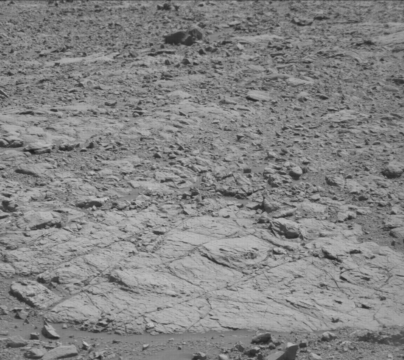
Protect Our Shared Future
You help us defend humanity and prevent asteroid impacts. Donate now to become a Planetary Defender!
Donate