Heather Hunter • Dec 23, 2016
GOES-R: What’s Next?
After a series of maneuvers in-orbit, GOES-R – now known as GOES-16 – has reached its designated location of 89.5°W, a longitude that passes through Ontario, Illinois, Guatemala, and the Galápagos. What happens next?
Over the next 6 to 12 months, NASA and NOAA will work together to calibrate the GOES-16 sensors and validate their data. Calibration is a crucial step in the life cycle of a satellite instrument. In order to interpret the instrument's data and compare it to other data sets, we need to know what its sensor’s response is to known inputs like a specific intensity of light or a natural surface. Validation is another important process, because it is a direct assessment of the quality of the resulting data. Without both calibration and validation stages, satellite data would not be useful. (Not for science, anyway. Uncalibrated science data can be very pretty to look at.)
To calibrate and validate a few of GOES-16’s instruments, NASA and NOAA will be using one of NASA’s ER-2 high-altitude aircraft. Built by Lockheed Martin after the design of high-flying U-2 military spy planes, the ER-2 are also known as “flying laboratories” and are an essential part of NASA’s Airborne Science Program. Besides performing calibration and validation of satellite instruments, the ER-2 also participate in collecting information about Earth resources, celestial observations, atmospheric chemistry and dynamics, and oceanic processes.
The ER-2 offer NASA Earth science a unique perspective, as they fly neither in space at spacecraft altitude, nor deep in the atmosphere at usual airplane cruising elevations. Usually flying in the lower stratosphere between 6000 and 20,000 meters (20,000 and 70,000 feet), above approximately 99% of the Earth’s atmosphere, the ER-2 are able to sample the atmosphere and simulate satellite missions. (Don't know your stratosphere from your troposphere? Read this post.) In fact, the ER-2 are invaluable platforms for sensor research and development, and are usually fitted with prototypes of future satellite sensors, or models of existing sensors for testing of future configurations.
In early November 2016, the ER-2 flew test flights with two new instruments: 1) the GCAS (Geostationary Coastal and Air Pollution Event Airborne Simulator), and 2) the FEGS (Fly’s Eye Geostationary Lightning Mapper Simulator). Both instruments are designed to support GOES-16’s Geostationary Light Mapper (GLM).
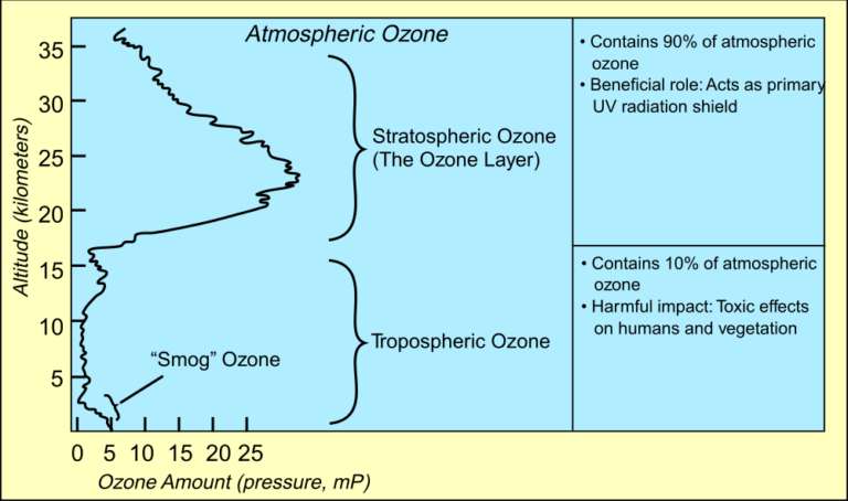
GCAS observes nitrogen dioxide, which is a byproduct of lightning strikes. This capability is important to atmospheric science, as nitrogen dioxide (and other nitrogen oxides) are transported vertically upward in the upper troposphere, where they play a role in the formation of tropospheric ozone. Additionally, thunderstorms are capable of transporting these same nitrogen oxides into the stratosphere, where they break apart stratospheric ozone. It is important to note that ozone in the troposphere is harmful, but ozone in the stratosphere is good – there, it protects us from harmful solar ultraviolet radiation.
Scientists flew FEGS on ER-2 to validate GOES-16's lightning detection capabilities by observing and mapping lightning strikes over the same time and locations as GLM. To do so, FEGS is made up of 25 photometers, which are instruments that measure the intensity of light. To be more specific, each of FEGS’s 25 photometers look to measure light with a wavelength of 777.4 nanometers (nm), slightly longer wavelength than the red end of the visible spectrum, which is the wavelength of light emitted by natural oxygen when heated by lightning.
FEGS also has 5 additional photometers that are designed to measure other atmospheric molecules, like nitrogen, and other wavelengths of electromagnetic radiation, such as ultraviolet (UV), that are also associated with lightning. Looking at lightning strikes at multiple wavelengths of the electromagnetic spectrum simultaneously offers scientists a comprehensive look at the processes leading up to, comprising, and following lightning. These data then allow scientists to try to predict the conditions that cause specific types and strengths of lightning, and what the relationship might exist between specific types of lightning and storm intensification.
The ER-2 airborne calibration and validation campaigns for GOES-16 are invaluable because they allow scientists and engineers to plan calibration and validation procedures once a satellite is in orbit. This kind of practice is almost always necessary before or after a satellite launches, since a satellite and its instruments undergo many changes both on its way to orbit and once it is in orbit. Being able to plan these procedures is an essential step in helping satellite teams prevent large systematic errors, thereby ensuring that satellite instruments will work as designed once in orbit above the Earth. Since we don’t have robots to service our satellites in space, just yet, the data produced by GCAS and FEGS will only help on-Earth engineers improve the quality and reliability of GLM – and GOES-16’s – data.
The Time is Now.
As a Planetary Defender, you’re part of our mission to decrease the risk of Earth being hit by an asteroid or comet.
Donate Today

 Explore Worlds
 Find Life
 Defend Earth


