
 Explore Worlds
 Find Life
 Defend Earth


Curiosity update, sols 748-763: Driving and Drilling at Pahrump Hills
Written by
Emily Lakdawalla
September 29, 2014
The biggest news on Curiosity of late is that the rover has drilled her fourth full drill hole on Mars! Drilling happened at a site called "Confidence Hills" on sol 759 (September 25, 2014). The previous drill sites were John Klein, on sol 182; Cumberland, on sol 279; and Windjana, on sol 621. This is Curiosity's first drill hole into what the science team thinks are Mount Sharp rocks.

But I'm getting ahead of the story. When I last wrote about Curiosity, it was sol 747, and the rover had finally descended into Owens Valley; she was less than 200 meters' drive from her drilling target at Pahrump Hills. On the way to Pahrump Hills, she passed by some absolutely amazing-looking outcrops of rock. This update is being written days later than I had initially planned because I spent so much time examining and playing with those images.
To set the stage, let's step back to sol 746. Curiosity was sitting atop a low outcrop at a spot called Jubilee Pass. The view takes in the ripple-filled Owens Valley in front of the rover, and the bright smudge of Pahrump Hills in the distance.

On the extreme right of this panorama, there is a curious-looking crack through the outcrop that caught the attention of the science team. So, before driving on sol 747, they took a large, detailed panorama of the outcrop. To me, this is the most exciting part. I have attempted to place a scale bar on it to give a sense of the size of this feature, but the scale bar could be off by 50% (either short or long), and of course the scale of the image changes as you go from the bottom (which is closer to the rover) to the top (which is farther).

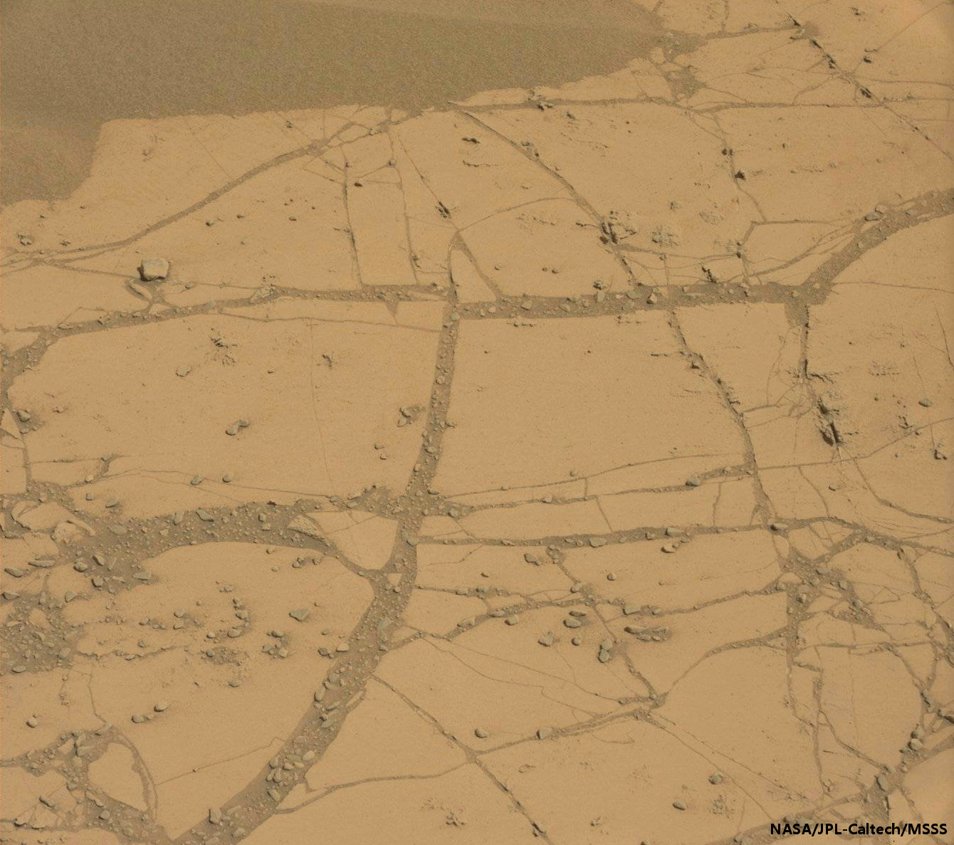
We're looking at an outcrop of very thinly bedded rock. There is a fracture in the rock, and discoloration and bright veins along the fracture. One might hypothesize that fluids once flowed along this fracture, and altered the surrounding rocks. Or it could be something else. In any case, Curiosity drove away after taking this photo. I don't see any ChemCam shots of this feature. There were a couple of other nearby Mastcam targets, including what looks like an incredibly thinly eroded layer of rock. The cohesion of these thin rock layers is really surprising to me, even in Mars' relatively low gravity (38% of Earth's).
So Curiosity drove on, pausing briefly to take in this view of the tracks she left after she crossed Jubilee Pass. At the end of the sol 747 drive, which was a relatively long one at 95 meters, she took the unusual post-drive step of capturing a full 360-degree view of her surroundings with the left Mastcam. The view contains tons of delicious outcrop making up the western end of Panamint Butte, as well as another nice perspective on her tracks. On sol 748, she re-imaged much of the Panamint Butte outcrop with her Mastcams, capturing views of some of the clearest-cut examples of crossbeds I've seen from Curiosity. Crossbeds form wherever sand-sized particles are being transported, either by wind or by water. Geologists will be able to read these rocks to say whether it was wind or water, and which direction the flow was happening.

After taking these photos, Curiosity drove a short distance to the east end of another outcrop named Upheaval Dome, presumably of the same material that Panamint Butte was made of. The rock at the rover's feet had a decidedly strange erosional expression. After taking the weekend off, they shot the target, named Shinarump, with ChemCam and Mastcam to take a closer look. But much of the pre-drive science time on sol 751 was devoted to a huge stereo Mastcam panorama of Upheaval Dome. Everywhere I look in this panorama, there are fascinating rock formations. There are crossbeds, and the crossbeds have been planed in different directions and then wind-eroded to make fantastic series of paper-thin layers. The thinly bedded rock is peppered with large round nodules -- from their look, I'd hazard a guess that they're concretions, but that's not the only possible interpretation, and I couldn't begin to tell you what mineral they're made of. Here is just one small piece of the panorama; please click through twice to enlarge it to its full majesty to appreciate all of the fine geomorphological detail.

After taking this fine panorama, they drove a total of 117.56 meters, the longest single drive since sol 665. And this was a sweet, sweet drive. The terrain is benign for the wheels, so the drivers didn't need to sweat every little detail; they could let some of the rover's own intelligence take over. As a rule of thumb, whenever you can clearly see the impressions of the wheel tracks in the soil, it's great driving terrain. That means it's soft and fine-grained enough for the rover's grousers to sink in and make good contact with the soil, allowing the webbing between the grousers to spread out the rover's weight across a wide area of wheel surface, but it's firm enough for the wheels not to slip. It also means that the next time HiRISE gets a picture of this area from orbit, the wheel tracks will show up as a clear dark double line on the ground.
To begin the drive, they neatly straddled a small pile of rocks. They drove about 40 meters and then hung a hard left turn in order to run the rover along what looks like a narrow bridge between two ripple fields; you can see the rover making little turns to adjust its position to follow that bridge and not stray into the ripples. Finally, a slight right turn took them up a slope to its peak. Nailing the center of that bridge between the ripple fields after driving 40 meters was pretty great. In order to do that, the rover really has to know exactly where it is, relative to where the drivers expected it to be. The rover does that with visual odometry, using stereo pairs of the images in the animation above to track the distance it's traversed from one image to the next. You can see in this map from curiosityrover.com just how well the rover threaded the needle between those two ripple fields.
Once Curiosity reached the top of that rise, she had a great view down onto Pahrump Hills, with two buttes on either side, and Mount Sharp behind it. This is it, what Curiosity has been aiming for. Pahrump Hills is an outcrop of relatively light-colored rock that the Curiosity science team thinks might represent the lowest-elevation rock unit they can reach at Mount Sharp. As such, it represents the beginning of the story they can tell about Mount Sharp. It's the first drilling target of their extended mission, and they expect to spend several weeks studying the outcrop, though not likely all from the same position.

Curiosity bumped forward to the outcrop on sol 753, putting a nice flat area of outcrop within reach. Here's a top-down view of the rover in her fourth drilling location.

Work proceeded very rapidly from there. On sol 753, just after arriving, they captured Mastcam panoramas of the area within reach of the arm. On sol 755, they picked a target, brushed it, then stuck the APXS on it to determine its elemental composition. That was Saturday. Sol 756 was Sunday, and the rover went right on to perform the mini-drill test, without having had any Earth command in the loop. That's awesome for two reasons: one, that brush-APXS-minidrill all happened autonomously; and two, that the rover drivers managed to get all that work sequenced in a single Earth planning day.
Unlike the previous attempt at a mini-drill at Bonanza King, this drill went great; it reached its full depth, even though the rock cracked as Curiosity drilled it. On sol 758, they imaged and lasered some cool-looking little rosettes named Mammoth and Morrison on the otherwise flat plates of the outcrop before brushing and APXSing again in order to prepare to drill. And on sol 759, they drilled again, at a target named Confidence Hills. Just one week between their arrival at the outcrop and the full drill. If they can achieve this kind of speed on a regular basis, the extended mission is going to see a lot more rock samples than the prime mission did! Here is a nice three-image sequence of the drilling work.
What's odd about this drill hole is that the tailings from the full drill hole look quite different from the tailings that came out of the firt drill hole. They are lighter, pinker, and clumpier. I'm not sure what that means! Hopefully CheMin will tell us.
After sol 759, things slowed down a bit. According to Ken Herkenhoff at the USGS blog, "there was a problem with one of the rover's gyroscopes that halted the transfer of drill sample to the scoop." The rover was preoccupied, anyway, with a software patch followed by preparing a SAM oven for ingesting a sample from the Confidence Hills drill hole. And the weekend intervened. But by sol 762 they were back to work and had sieved the drill tailings. With the weekend over, they're now ready to deliver the sample to CheMin.
What happens after that? The site where they drilled is at the base level of the Pahrump Hills outcrop. They will probably not stay exactly where they are. But now that they are at the base of Mount Sharp, it's time for them to start reading these rocks like the pages of a book. They could drive a short distance away to access a different part of the outcrop; the whole outcrop represents several vertical meters of rock section, so there could be a long of Mars history recorded in it. Or they may decide one sample was enough, and drive off to new rocks. We'll have to wait and see!
Protect Our Shared Future
You help us defend humanity and prevent asteroid impacts. Donate now to become a Planetary Defender!
Donate