
 Explore Worlds
 Find Life
 Defend Earth


White Rock through the ages: Mars Express (2004-present)
Written by
Emily Lakdawalla
March 27, 2008
When we last visited White Rock on Mars, both Mars Global Surveyor and 2001 Mars Odyssey were mapping the planet. In 2004, another four spacecraft were approaching: the Mars Exploration Rovers Spirit and Opportunity, and, for the first time, two missions that were neither American nor Russian: Japan's Nozomi and the European Space Agency's Mars Express. Nozomi's mission was doomed to failure, but Mars Express joined the traffic jam at Mars and quickly returned uniquely beautiful images with a camera system unlike any that had been sent to Mars previously.

Mars Express' High Resolution Stereo Camera (HRSC) is a pushbroom style of digital camera, like MOC on Mars Global Surveyor and THEMIS on 2001 Mars Odyssey, so it captures long, narrow image strips. But while MOC is a monochrome camera, and THEMIS' color channels share a common boresight, the nine channels of HRSC all point in slightly different directions, some facing forward along the orbital path, some pointing nadir (downward), and some facing backward. By capturing forward-looking and backward-looking images simultaneously, looking at the same landscape from two different directions at nearly the same time, HRSC builds a data set that can, after some data processing, be used to develop three-dimensional, color views of Mars' landscape. Something about the data processing that they do with HRSC images brings out subtle color variations in ways that you tend not to see in images from other orbiters, giving them, to my mind, a painterly quality; they remind me of the artistic scenery from classic animated movies. It helps that Mars Express views Mars with the Sun fairly high overhead, which reduces shadows and makes color variations more obvious.

The somewhat difficult processing required to generate HRSC pictures, coupled with ESA's having a less aggressive media relations office than NASA and JPL, has meant that HRSC images have been less visible than Mars images from NASA missions, which is a shame, because they're gorgeous. However, a year ago, the HRSC team at the Freie Universität Berlin made it incredibly easy for people to locate HRSC's beautiful Mars images, through a tool called HRSCview. When HRSCview first appeared, only the images were available, but now you can also access many digital terrain models (DTMs) representing the topographic data calculated from HRSC camera images. This tool is even easier to use than ASU's Mars global data website; by using the little buttons and menus to the left of the HRSCview screen you can quickly obtain the view of any feature that you want. Below is a screen shot from HRSCview, showing one of the images, with elevation contours superimposed.

Using HRSCview, you can quickly find that there are two sets of HRSC images of White Rock, one from orbit 330, April 23, 2004, and one taken on orbit 1201, Christmas day 2004. The orbit 1201 image is by far the better of the two. The highest resolution, grayscale data is 25 meters per pixel, just a bit poorer than the best from Mars Odyssey. One of the neat things about the Odyssey data was that the relatively broad swath of an individual THEMIS image allowed scientists to spot an outlier of White Rock material in a small crater to the southeast of White Rock. Well, HRSC's swath width is even wider than Odyssey's; the HRSC detector is a whopping 5,184 pixels across. So an HRSC image of White Rock contains quite a lot of surrounding terrain -- in fact, it covers as much area as a single Mariner 9 frame, but at roughly 20 times better resolution.

I hunted around to see if there were any other craters that had anomalously bright deposits in their floors. I didn't see anything within Pollack crater, but there was a suspicious looking spot on the rim. I checked, and there's no MOC imagery of this location, nor is there anything from HiRISE or CTX; there's also nothing from THEMIS that's better than 100 meters per pixel. There is actually a view from Viking, also showing a white floor to the little crater, but its resolution is no better than HRSC's. So we'll have to satisfy ourselves with the HRSC view for now. Maybe, if the Mars Reconnaissance Orbiter HiRISE team starts their promised program that will permit members of the public to request targeted images, I'll see if I can get that spot into the queue. (I sent an email to Alfred McEwen asking if they were still planning on launching this program, and he said they were indeed, perhaps this summer, if the instrument team can make the time to get it up and running.)

OK, now for the "stereo" part of the High Resolution Stereo Camera. Through HRSCview I find that both the orbit 330 and 1201 images also have digital terrain models available. With digital terrain models available, you can do snazzy 3D animations. Well, some people can. I don't have the necessary software or computer power, but Doug Ellison does, and was kind enough to set his computer chugging away for a dozen hours or so to generate a couple of movies flying around the HRSC data set. Here's a still; download options for very pretty movies are below the still.

And, for completeness, here is a red-blue anaglyph of the view; you need red-blue glasses to get the 3D effect.

The topography of White Rock turns out to be more subtle than it would appear. There are three kilometers (two miles) of relief from the rim to the floor of Pollack crater, but only about 10 percent as much relief -- 300 meters -- within the White Rock deposit itself. We knew this already from MOLA on Mars Global Surveyor, but knowing and understanding aren't always the same thing; with the perspective from HRSC you can really see how White Rock could be the remnant of a pile of sediment that once filled the very bottom of the crater floor, and it no longer seems (to me) to be a stretch to argue that this crater-filling deposit could have mostly eroded away.
Mars Express also carries a visible and infrared imaging spectrometer called OMEGA, the first instrument of its kind sent to Mars. There had been other spectrometers, like TES on Mars Global Surveyor, which studied the longer-wavelength thermal portion of the infrared spectrum with low spatial but high spectral resolution, and THEMIS on Mars Odyssey, which studied visible and thermal wavelengths with high spatial but low spectral resolution. OMEGA was the first near-infrared imaging spectrometer sent to Mars, and the first to have high spectral resolution with reasonably good spatial resolution. All these trade-offs between wavelength range, pixel size, and spectral resolution can be headache-inducing; and I'm not even bringing fractional coverage of the planet into the conversation. So just take my word for it when I say that OMEGA is a wholly different beast from TES and THEMIS.
Probably the greatest success of OMEGA has been the positive identification at Mars of small exposures of layered rocks bearing minerals that require liquid water for their formation, like sulfates and salts. White Rock seems a natural place to look for these. The OMEGA team mentioned in a paper they published in Science that "not all light-toned layered deposits...show evidence for sulfates, such as the White Rock area within Pollack crater: OMEGA confirms, with sub-kilometer-resolution mapping, the lack of evidence for an aqueous origin."
I fired off an email to OMEGA principal investigator Jean-Pierre Bibring to request some illustrations of this, but I never got a reply. So it was sheer luck that, while chatting with new blogger Ryan Anderson a couple weeks ago at the Lunar and Planetary Science Conference, I brought up this frustration, to which Ryan replied offhandedly that he had computer code that could produce images from archived OMEGA data, and was I interested? Indeed I was; Ryan came through for me with the images below. My apologies to Ryan for how much of his time this took. (I should probably also apologize to Ryan's graduate advisor, who probably doesn't know about the time Ryan spent working for me and not him!)
The images are mosaics of three observations, a high-resolution one (at about 500 meters per pixel) that was obviously targeted at White Rock, overlaid on a couple of lower-resolution ones. There are noticeable differences among the three observations, which result from various calibration issues. This first image shows the average albedo of the area across all the wavelengths sampled by OMEGA, from roughly 0.5 to 5 micrometers. It looks broadly similar to the high-resolution image I showed above, down to the oddly dark spot to the north of White Rock that I hadn't noticed before.

Each of the pixels in that image actually contains a wealth of information on how a 500-meter-square bit of Mars reflects light across hundreds of individual bits of the electromagnetic spectrum. That is, from each point, you can collect a spectrum, a graph of how reflective the pixel is with wavelength. The graph below contains four spectra measured by OMEGA, two from the White Rock area and two from Meridiani Planum, Opportunity's landing region, for comparison. (Ryan chose Meridiani spots for comparison because that's what he's most familiar with, and the spectra were ready at hand.)
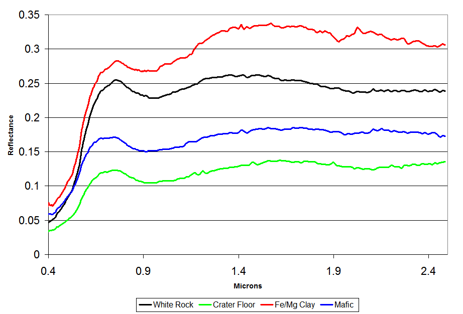
All the spectra bear similarities. They all have a strongly upward slope from 0.4 to 0.7 microns, the visible range, which gives all of them the overall red color that is common to Mars. All have a dip near 1 micron, indicating the presence of iron; the White Rock, crater floor, and mafic spectra also contain a much smaller dip near 2 microns, indicating that the iron and magnesium is found in a mineral called pyroxene. The clay spectrum has noticeable dips at 1.9 microns (indicating that water is bound in the chemical structure) and 2.3 microns (indicating the presence of hydroxyl, OH- groups, another signature of the presence of water). Although White Rock bears some similarity to the clay spectrum, it does not contain those two dips, so there is no clear evidence for the presence of water.Image: Courtesy ESA / OMEGA / plot by Ryan Anderson
As you might imagine, interpreting what these squiggly lines actually mean is a rich field in planetary science, one that I am only dimly aware of and one that Ryan is relatively new to, so you'll have to take our interpretations with a grain of salt; but here we go. All the spectra bear similarities. They all have a strongly upward slope from 0.4 to 0.7 microns, the visible range, which gives all of them the overall red color that is common to Mars. All have a dip near 1 micron, indicating the presence of iron; the White Rock, crater floor, and mafic spectra also contain a much smaller dip near 2 microns, indicating that the iron and magnesium is found in a mineral called pyroxene. The clay spectrum has noticeable dips at 1.9 microns (indicating that water is bound in the chemical structure) and 2.3 microns (indicating the presence of hydroxyl or OH- groups, another signature of the presence of water). Although White Rock bears some similarity to the clay spectrum, it does not contain those two dips, so there is no clear evidence for the presence of water. One easy thing to read from the spectra is the overall brightness of the measured spots. The floor of the crater is by far the darkest of the four; its plot never crawls above a reflectance of 0.15 (out of 1). Interestingly, White Rock is not the brightest plot; clays in Meridiani are brighter. Once again, we have proof that White Rock looks "white" not because it is, but instead because the floor of the crater is really anomalously dark.
Because OMEGA is an imaging spectrometer, you can examine spectra like these for every single pixel in the image. But that makes it a bit hard to see the big picture, to identify the spectral variations across the scene. One thing a spectroscopist can do is to take each pixel in the OMEGA image and calculate certain properties of its spectrum, then represent those properties on a new image. The eight pictures below examine different features of the spectra at each point in the OMEGA image.

The pictures labeled "1.9" and "2.2" and "2.3 μm band" are looking for characteristic dips in the spectra like the ones you can see in the red line on the graph above. A dip at 1.9 identifies water; a dip at 2.2 identifies the presence of aluminum hydroxide (AlOH), and a dip at 2.3 identifies the presence of iron or magnesium hydroxide (Fe/MgOH). All of these are intended to search for clay minerals. "Hot" colors identify deeper dips in the spectra. Ryan's code is finding some hints of clays in speckles across the crater floor, but none at all in White Rock itself.
All in all, in fact, there's remarkably little about the composition of White Rock that can be interpreted from these maps, except that there's just no evidence that water played a role in its formation. One thing you can say is that there's a pretty strong olivine signature in the dark sand of the crater floor surrounding White Rock. Olivine is a very common mineral in the solar system, and its presence generally indicates that you're dealing with an area that hasn't experienced a lot of geologic processing. In particular, if you get olivine wet, it weathers extremely quickly into clay minerals. So one thing you can take away from the OMEGA results is that the crater floor hasn't been wet since that olivine-bearing sand got in there.
I think.
We only have one spacecraft left to go in our travels through time at White Rock, but it's a doozy: Mars Reconnaissance Orbiter. Stay tuned!
If you missed the previous installments, here they are: Mariner 9 - Viking - Mars Global Surveyor - 2001 Mars Odyssey.
Protect Our Shared Future
You help us defend humanity and prevent asteroid impacts. Donate now to become a Planetary Defender!
Donate