
 Explore Worlds
 Find Life
 Defend Earth


Isostasy, gravity, and the Moon: an explainer of the first results of the GRAIL mission
Written by
Emily Lakdawalla
December 11, 2012
Last week the GRAIL lunar gravity mission published their first scientific results, and what they have found will send many geophysicists back to the drawing board to explain how the Moon formed and why it looks the way it does now. To explain how, I'm going to have to back way up, and explain the basic science behind gravity data. It's a really important field because it's often the only way that we can learn about the deep interiors of other worlds. Gravity data gives us a kind of x-ray vision into what's happening inside a planet, and so helps us understand the planet's past.
A paragraph just for the pedants out there (you know who you are): when I talk geophysics, I need a word that means "anything big enough to have internal geology." I'm going to just say "planet" when I mean that; it's much easier than "planets and dwarf planets and round moons." It's the geophysicist's definition of the word "planet," which is quite a bit different from an astronomer's use of the same word. And yes, when I say "geophysics," I'm not just talking about Earth, I'm talking about all planets.
Okay. So, first of all, let's talk about how planets are built. Most planets are differentiated: they have layers of different materials separated by their densities. Broadly speaking, planets have cores (densest), mantles (less dense), and crusts (least dense). The terrestrial planets -- Mercury, Venus, Earth, the Moon, Mars, and Io -- have metallic cores, mantles made of iron and magnesium silicate minerals like olivine and pyroxene, and lighter-weight silicate crusts. All of what I will be talking about in this post concerns the upper two layers, the mantle and crust.
If everything started out molten and nothing at all happened after cooling, you'd wind up with a round object where the force of gravity was exactly the same everywhere. And it'd be a very boring place, all smooth, no topography, and no history to talk about.
Lots of insults can happen to planets to disturb this perfectly smooth state. On the Moon, the two most obvious ones are impact cratering and volcanism. Roughly speaking, an impact crater digs a big hole in the ground, and volcanism adds a pile of rock on top of the ground.
A hole is a place where there's missing mass. A mountain is a place where there's extra mass. So when you fly across a hole in the ground, you feel the force of gravity to be lower than elsewhere. It's a "negative free-air gravity anomaly," to a geophysicist. When you fly across a mountain, the force of gravity is locally high. This is a "positive free-air gravity anomaly." The free-air part has to do with assuming that you're at some fixed elevation. This and all other cartoons in this post are by me. Do not use them to plan spacecraft navigation.
For broad areas of the Moon, that's exactly what GRAIL saw. Here's a section of the heavily cratered lunar farside with the GRAIL gravity map on the left and a shaded topographic relief map on the right. In the center, where I've used the GRAIL map to color the relief map, you can see how well the gravity and topography line up, with craters showing negative free-air gravity anomalies. (This and all other GRAIL data shown here are courtesy of NASA / JPL / GSFC / MIT.)
And that's how things stay, for relatively small craters on the Moon. But for very big craters, another effect operates. Although rock seems like a solid and immovable substance, if you give it long enough time, and if you warm it up a bit, it can behave like a fluid, albeit a very slow-moving (viscous) fluid. What happens when you dig a hole or build a mountain out of a fluid? The fluid will flow, and after some time has passed you'll get a smooth world again. Here's another of my patented cartoons:
This does happen on solid worlds all over the solar system, including our own. It's easiest to observe on worlds made of substances that are happy to flow, even while solid. Consider Tethys. Tethys is a moon of Saturn whose mantle and crust are made of ice. It's solid ice, but it's warm at the bottom, and solid ice actually flows quite readily, given geologic time. A long time ago Tethys experienced an enormous impact, which dug the crater named Odysseus. In the time since Odysseus formed, Tethys' mantle flowed, pushing up the crater floor so that Odysseus is no longer a hole in the ground, and Tethys is very close to being round. All that remains of the original crater shape is the steep rim and a complex that used to be a central peak or peak ring.

If we put GRAIL in orbit around Tethys, you wouldn't see a huge deep blue negative gravity anomaly associated with any kind of missing mass within Odysseus. You'd see some small-scale stuff associated with the rim and the peak, but much of the basin would have the same gravity as the region outside Odysseus.
Things get a bit more complicated -- but also more interesting -- if you have a crust and mantle that have different densities. If a crater digs a hole in the ground, it removes low-density crust, but doesn't remove any buried high-density mantle. When the mantle flows in to fill the hole, you are replacing less-dense stuff with more-dense stuff. The process is driven by gravitational potential energy. When there is the same amount of mass underneath the crater as there is underneath the area outside the crater, the gravitational potential is equalized. You finish with a hole in the ground, albeit a shallower one than you started with. If you ignore the edge effects (which you can't, really, but I don't want to make this discussion more complicated than it already is), the force of gravity is again the same everywhere. You wind up with places where the topography is low, but there's no free-air gravity anomaly.
Inversely, if you add crust to the top of the crust, you're adding mass. This extra mass will sink, pushing out higher-density mantle until everything is balanced. In the end, you'll still have a mountain, but a shorter one than you started out with. You wind up with a world where holes in the ground mean thin crust and mountains mean thick crust, and there's no free-air gravity anomaly.
Geophysicists refer to this state of balance with the word "isostasy." Isostasy is like buoyancy -- less dense stuff is buoyant and rides high on the fluid mantle. This partially explains why Earth has continents and ocean basins. The crust is quite thin underneath the oceans, only 5 or 10 kilometers. It's thicker under continents, 20 to 40 kilometers. So the oceanic crust rides lower in the fluid mantle, and ocean basins are low.
There's one other fundamental piece to the isostasy puzzle. It's the fact that not all crust is created equal. Mantles flow over time, so it's not a bad first approximation that the mantle has constant density. But crust can vary a lot in composition, in temperature, and in porosity, which means you have to worry about how the density of crust varies from place to place. In an extreme scenario, you can explain long-term holes in the ground and long-lived mountains just by varying the density of the crust.
Both of these cartoons have the same surface topography, but they represent very different geophysical situations. In the top cartoon, topographic highs are supported by deep crustal roots, while topographic lows are found above thinned crust. In the bottom cartoon, mountains occur where there's less-dense crust, and basins where there's more-dense crust. The two different styles of isostatic compensation are named for the people who first described them, G. B. Airy and J. H. Pratt.
This is the other half of the explanation for why Earth's ocean basins have low elevation. Oceanic crust is relatively dense basaltic rock. Continental crust is made of rocks with a considerably less dense granitic composition.
Working together, Pratt and Airy isostasy make Earth's gravity field remarkably constant, given how much variation there is in topography and how quickly geologic activity is trying to change things. The average acceleration due to gravity on Earth is 9.8 meters per second squared. Geophysicists measure local variations in geology using units of milligals, where a "gal" (short for galileo) is 1 centimeter per second squared. So average acceleration due to gravity is roughly a million milligals. Variations in Earth's gravity fields are mostly within 100 milligals of average -- 0.01% of the strength of the field.
All right, so that's the ideal situation. The real world is, of course, much more complicated. Mantles aren't perfectly fluid, they are solid, and they do have some strength. If the hole that you dig (or the mountain that you build) is small enough, there won't be any flow at all, and you get a gravity field that matches topography very well. Your crater or mountain is said to be "uncompensated." Which is the situation in that area of cratered lunar highlands in the GRAIL image I showed before.
Since uncompensated topography contributes so much to the GRAIL map of the lunar gravity anomaly, it's an interesting exercise to take our original map of the gravity field -- which is usually described as a map of the "free-air anomaly" -- and subtract out the effect of uncompensated topography. That's one of the versions of the gravity map that GRAIL principal investigator Maria Zuber presented at last week's press briefing. To make such a map, they had to make an assumption about how the density of the crust compares to the density of the mantle. After the correction, the map that shows you where there has been isostatic compensation, and what kind of compensation there was. This type of gravity map, where a topographic correction has been applied, is called Bouguer (pronounced "boo-gay") anomaly.
In a Bouguer anomaly map, compensated mountains will have negative anomalies (because of the "missing" mass in their low-density roots). Compensated basins will have positive anomalies (because of the "extra" mass in the high-density plugs of mantle that have risen up underneath them). So if you look at a Bouguer map, you're seeing sort of an inverted map of crustal thicknesses. High Bouguer gravity means thin crust, low Bouguer gravity means thick crust. Here's the new GRAIL Bouguer gravity map of the Moon that Zuber presented. The rightmost of the three globes mostly shows the nearside, peeking a little over the left side so you can see the bull's eye of Orientale. The center mostly shows the farside, but it peeks a little over the right side to pick up Orientale again.

There are three features I want to point out in this map. First of all, most of the small-scale variation visible in the free-air gravity map has gone away. That means that most of the small-scale signal in the gravity field really is due to uncompensated topography. It also means that the assumption of the crust being pretty much the same density everywhere works pretty well. There are local variations visible especially in the highlands, though it's tough to tell how large the variation is without contour lines.
Now, the Moon should have local, small-scale variations in crustal density due to local geology; the fact that the variations are small and smooth means (Zuber argued while presenting these results) that impact cratering has completely battered, bashed, fragmented, mixed, and remixed the upper couple of kilometers of the crust, totally homogenizing it. Previous maps of lunar gravity have not had high enough detail to see this beautiful match between topography and gravity; so this is a new GRAIL result.
A second notable feature: generally, the crust is thick (low Bouguer gravity, blue color) on the farside and thin (high Bouguer gravity, red color) on the nearside. This is a known feature of the Moon; it produces what's known as its center-of-figure/center-of-mass offset. The Moon's geometric center is offset from its rotational center by several kilometers. One hypothesis to explain this oddity is that most of the farside is covered by very thick deposits of ejecta from the giant south pole-Aitken basin.
Finally, many of the lunar basins have great honking huge positive gravity anomalies. They're noticeable in the free-air gravity map but even more so in the Bouguer map. These, too, have been recognized for quite some time. They're called "mascons," mass concentrations, places where there is much more mass than it seems there should be. The Moon's mascons are a real pain for orbital navigation; their gravitational effect destabilizes orbits, and it takes a lot of work to keep lunar orbiters from crashing. In fact, Zuber said at last week's press briefing that in their new, low-elevation extended-mission orbit, GRAIL has to perform trajectory correction maneuvers three times a week in order to keep from crashing. And once they quit doing those maneuvers, they're going to crash very quickly. The mission will end on December 17 at 14:28 PT / December 18 00:28 UT. (There's a press briefing planned for Thursday to announce where the crash will be.)
The crust must be ultra-thin under the mascons. In some places it would appear that the crustal thickness is effectively zero -- the impacts dug holes all the way through the low-density crust to reach the high-density mantle. In many mascons, even this isn't enough to account for all the Bouguer anomaly. You also need an uncompensated pile of extra mass. Many of the basins are, in fact, filled with basaltic lavas, which (if not compensated) could account for some of the positive gravity anomaly. But not all of them are. The puzzle of why some lunar basins that aren't filled with volcanic flows do have mascons is an area of active research and debate.
All of that was to explain the first of the three Science papers published this week, the one introducing the GRAIL data. But there were two more related papers, in which GRAIL team members performed computational tricks to wring more information out of the data set.
The first of these was a paper about the lunar crust presented at the briefing by Mark Wieczorek. He took the GRAIL data set and essentially performed a high-pass filter on it, removing long-wavelength features (large basins and other regional features). What's left behind, the short-wavelength features, should all be uncompensated, too small for isostasy to be able to make mantle flow to lift up crater floors. Therefore, the Bouguer gravity anomaly in such a map should be zero.
A few paragraphs up, I told you that in order to calculate the Bouguer anomaly from the free-air anomaly, you have to assume a crustal density. Well, Wieczorek and coworkers approached the problem a different way. They took the high-pass-filtered gravity map, forced the Bouguer anomaly to be zero, and solved for what the crustal density would have to be in order to make that happen. They avoided places where dense mare basalts have covered up the primordial lunar crust. Here is their map of lunar crustal density in all the places not covered by mare basalt.

There is one big very surprising thing about this map. The average density is 2550 kilograms per cubic meter. This is much, much lower than what has been assumed for lunar crust; in fact, it's lower than the density of granite. We know what the highlands crust is made of, we have samples of it: the density of the minerals that makes up the crust is around 2800-2900 kilograms per cubic meter. For the Moon's density to be so low, Wieczorek says, it must be very porous, fractured and busted up to give it about 12% void space, to a depth of several kilometers below the surface. This is an important GRAIL result. The mission has given us X-ray vision to see that the Moon's crust is absolutely shattered from the surface for thousands of meters down. In places where the crust is very thin, even the uppermost mantle may be fractured and porous.
Looking at the map a bit more closely, you can see wide variations in the crustal density. In some places, like the south pole-Aitken basin on the lunar farside, the crustal density is very high. In other places, like around the most recent basins Orientale and Moscoviense, the density is anomalously low. (Orientale is the blue-ringed basin on the far left side of the density map; Moscoviense is the much smaller blue-ringed basin up and to the left of center on the right-hand map.) Wieczorek cites compositional information from other spacecraft that suggests that the south pole-Aitken basin is exposing dense, mafic rocks that originated at great depth, while the recent basins would be surrounded by thick deposits of broken-up impact ejecta that would be more porous than average.
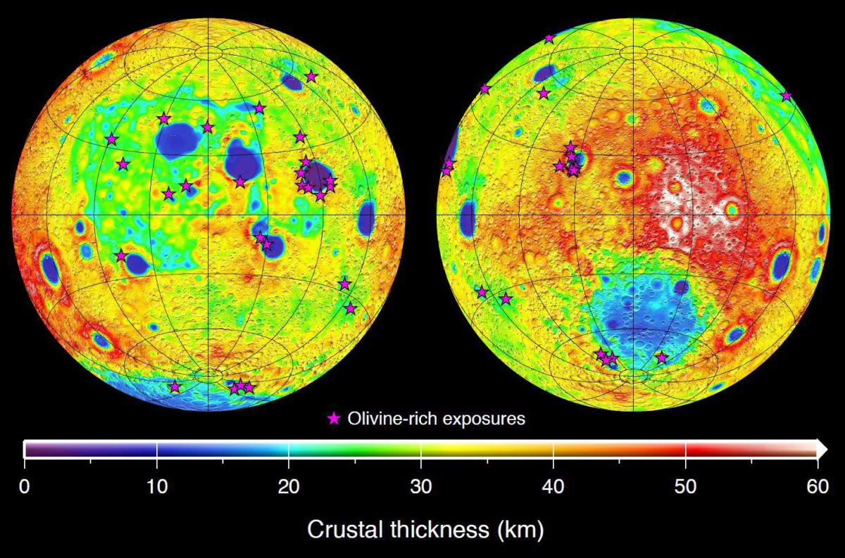
With the map of crustal density in hand, Wieczorek could go back to the original free-air anomaly map and do a better job of deriving the Bouguer anomaly. He used that map, in turn, to calculate the thickness of the crust. This map shows crustal thickness is near zero under a few of the impact basins (particularly Crisium and Moscoviense) and some of the deepest craters inside the south pole-Aitken basin (Humboldtianum, Apollo, and Poincaré). And the crust reaches a high of 60 kilometers on the farside. Kaguya compositional data support the GRAIL conclusions. There's evidence for the mantle mineral olivine being exposed in precisely those places where GRAIL sees the thinnest crust: Crisium, Moscoviense, and Humboldtianum.
The average crustal thickness that Wieczorek and coworkers calculated, 34-43 kilometers, is much lower than has previously been assumed. Why is that important? Because when you work out the math to figure out what the bulk composition of the Moon is, given this thinner crust, you wind up with numbers for the abundance of aluminum that are a much better match to Earth's aluminum abundance than they were before. Previously, an apparent compositional mismatch had been a problem dogging the giant impact hypothesis for the Moon's formation. The GRAIL result makes for a compositional match.
At the end of the presentation, Wieczorek stepped back and discussed some implications of the new GRAIL findings. The Moon, with only limited surficial geologic activity and a beautiful record of the solar system's impact history, presents a simplified starting case for what all the terrestrial planets would have looked like before other processes (volcanism, tectonism, and water and wind erosion) took over. Thanks to GRAIL we now suspect that all the terrestrial planets started out with a totally broken-up and brecciated crust. Fluids travel readily through such a fractured material, so early Earth and Mars could have seen very large amounts of water seep deeply into their crusts. On Mercury and the Moon, which wouldn't have had water, the brecciated crust would have had a different effect: all those pore spaces it would have reduced the crust's ability to transmit heat from the interior to the exterior, acting like a planetary Thermos to keep the hot inside part hot for longer than we had previously imagined.
Still with me? There's one more paper, the one that most fulfills the promise for GRAIL's X-ray vision. As old as the Moon's surface is, it's still at least 700 million years younger than the Moon itself. Everything of the original surface of the Moon that existed more than 3.8 billion years ago has been obliterated by impact craters. Jeffrey Andrews-Hanna presented a paper that used GRAIL to peer deeper into the Moon's past than ever before, beyond that 700-million-year cutoff.
Andrews-Hanna began with the Bouguer map (not Wieczorek's map, but instead the one that assumes a constant crustal density), and then calculated its gradient. The gradient is the slope of that gravity map. For any point on the surface, you get the gradient by looking around and finding the steepest slope rising or falling from that point. Where the gravity varies a lot over short distances, the gradient map will have a high or a low; in places where the gravity is smooth and unvarying, the gradient is zero.

The most obvious feature of the map is that concentric rings surround the mascons. Ignore the mascons, though, and a different kind of feature leaps out: blue lines. There are at least 20 and maybe as many as 60 of them. They are nearly perfectly straight, following great circles on the lunar surface. Mapping them on the gradient map and then overlaying them on the Bouguer map, Andrews-Hanna found that they were associated with positive gravity anomalies.

So they're very long, very straight features made of relatively dense material. To a geologist, the obvious interpretation is a dike. A dike is a place where a fracture opens up underground, and magma squirts in and solidifies. The dikes, if that's what they are, are old: Andrews-Hanna shows that later craters and basins obliterate them.
Dikes happen in places where there is extension of the crust. They can't happen in places where the crust is getting squeezed; that prevents fractures from opening, and lava can't flow in. On Earth, you see dikes in rift zones. The crust is extending, pulling apart, and cracks open up that get filled by lava, forming dikes. Andrews-Hanna's dikes have no preferred orientation, though, so instead of a pull-apart rift, they seem to be telling us that the Moon's entire crust expanded, in every direction, like a balloon.
The expansion isn't much -- we're talking a diameter increase over the entire moon of just a couple of kilometers -- but still, it's weird. It's not unheard-of, though. We see the entire crust expanding on bodies in the outer solar system -- Saturn's icy moons, for instance -- because as liquid water turns to ice, it expands, so aging icy moons develop extensional cracks to accommodate their swelling insides.

But ice worlds are not rock worlds. Rock (like almost everything except water) shrinks as it cools, so you expect to see compressional features. We do see that on Mercury, whose surface is completely covered with structures called "rupes" or "wrinkle ridges," where the crust has had to contract, buckling and folding, to accommodate the shrinking interior. How in the world can you make the Moon expand when cooling should have made it contract throughout its history?

Andrews-Hanna pointed out that some theorists have predicted exactly this situation. The paper he cites was by Sean Solomon, principal investigator on the MESSENGER Mercury mission, who was trying to explain how Mercury could have wrinkle ridges caused by global contraction if the Moon does not.
If you condense the Moon from a ring of debris orbiting Earth following a collision, the first nucleus of the Moon will actually be quite cold. As it grows, the increasing energy of the impacts of stuff onto the proto-Moon would make the Moon's mantle hotter than its deep interior; you could wind up with a cool, solid center surrounded by a hot, liquid mantle. The heat from the mantle would take time to propagate into the interior; as it did, the warming center of the Moon would expand, producing exactly the kind of global extensional stresses that could make this set of dikes. The model has this expansion happening at the correct time, too: before the Moon was 500 million years old, which would be before the end of the basin-forming impacts.
Unlike Wieczorek's brecciated-crust story, which would tell us about what was happening on the other terrestrial planets, Andrews-Hanna's initial-expansion scenario is a uniquely lunar one that could have happened nowhere else in the solar system that we know of.
This is a wonderful example of how a rich new data set from one planet can tell us not only about that planet's history, but also inform our understanding of the rest of the solar system. It makes me wonder what it would be like to put a GRAIL-type mission in orbit over Mars or Ganymede or Europa. Someone asked Maria Zuber that at the press briefing, whether there were any missions being prepared to places beyond the Moon. "There are certainly discussions," she said, but "someone would have to propose them." If I were in her position, having run the gauntlet of proposal after proposal and finally bringing my Discovery mission to fruition, I might rather spend the rest of my career on research rather than going through all that again. But I'd sure be happy to advise someone else on how to make a bid for a GRAIL 2 to visit another planet.
Thanks to Steven Hauck for his helpful comments on a draft of this post, and to Jay Melosh for his excellent textbook Planetary Surface Processes, which helped refresh my memory.
Protect Our Shared Future
You help us defend humanity and prevent asteroid impacts. Donate now to become a Planetary Defender!
Donate