Emily Lakdawalla • Oct 30, 2008
MESSENGER's Second Mercury Flyby: Ancient Geology, Active Atmosphere
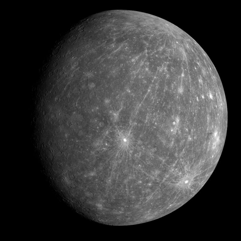
When MESSENGER flew past Mercury for a second time on October 6, 2008, its cameras snapped photos of an impressive 30 percent of the planet's surface that had never previously been seen by spacecraft. As fascinating as the new images are, however, the science team was more excited by the unexpected activity and complexity of the interactions among the solar wind, magnetic field, and tenuous atmosphere of the innermost planet. They presented early results from the flyby at a press briefing held at NASA Headquarters yesterday.

Filling in Mercury's Terra Incognita
MESSENGER co-investigator Mark Robinson presented the atlas of Mercury, and how MESSENGER has filled in most of the remaining gaps. Prior to MESSENGER's two 2008 encounters, the only spacecraft images came from Mariner 10, which flew by Mercury three times in 1974 and 1975. Its orbit was such that it always passed by Mercury when the same hemisphere was sunlit -- primarily the eastern hemisphere, from 350 through 0 to 170 degrees East longitude -- so its images only covered about 45 percent of the planet, and all at the same illumination angle.
MESSENGER's first flyby, on January 14 of this year, was under different illumination conditions, with the Sun lighting up Mercury from 95 to 275 degrees east. Images from that flyby covered about another 20 percent of the planet that hadn't been seen before. Just as important, areas that had been seen under high sun by Mariner 10 were imaged again in slanting sunlight by MESSENGER, and vice versa. High sun is better for seeing color and compositional variations across the surface; low sun is better for seeing topographic features like crater rims and mountain ridges.

Now, with MESSENGER's second flyby, the lion's share of the black space on the atlas of Mercury has been filled in. The second flyby occurred almost exactly one and a half Mercury solar days after the first one, so almost the exact opposite hemisphere -- from 273 to 93 degrees east longitude -- was in sunlight. Images from the flyby covered slightly under 30 percent of the planet. In total, MESSENGER has imaged 80 percent of Mercury, and, when that data is combined with the Mariner 10 data set, fully 90 percent of the planet has been mapped by spacecraft, with the largest gaps at 80 degrees longitude and at the poles.
The newly seen face of Mercury contains some spectacular features, notably a recent impact crater near the north pole whose extensive ray system extends right around the planet to the opposite pole. By and large, though, the western hemisphere of Mercury contains similar sorts of features to the previously mapped eastern hemisphere. Thus Mercury is globally fairly uniform, in sharp contrast to the Moon and Mars. The Moon's nearside, with its extensive volcanic maria, is sharply different from its farside, and Mars has numerous differences across hemispheres -- the north-south dichotomy between northern volcanic lowlands and southern cratered highlands, and the extensive Tharsis volcanic complex on one hemisphere that has no equivalent on the opposite hemisphere. Even Earth has one hemisphere dominated by oceanic crust (the Pacific ocean), while the opposite hemisphere has a mix of continent and ocean. Only Venus seems to have as globally uniform a surface as Mercury does.
Even if feature types are similar across the planet, there is plenty of evidence in the MESSENGER images to prove that, locally, Mercury's geology is quite complex. Robinson pointed to many craters that have bright blue ejecta, as seen in false-color images created using wavelengths of light invisible to human eyes. Robinson said that these blue deposits had been seen in Mariner 10 images, but the data was not of a high enough quality to indicate whether the blue material came from beneath the surface or was a coating atop the surface. In the MESSENGER data, "we see them all over the planet, and they are excavated from depth" by impact craters, Robinson said. But, he pointed out, one crater may excavate this blue material, while a similar-sized crater nearby may not. This proves that, beneath its surface, Mercury is far from homogeneous. If it's layered, its layers may be discontinuous, petering out laterally; or it may not be layered at all, but instead built of numerous volcanic intrusions all crosscutting each other.

It's just one of many puzzles that will be studied by the MESSENGER team once the spacecraft enters Mercury orbit in March of 2011. At that point, too, Robinson said he hoped to be able to use the MESSENGER instruments to determine what all these surface materials are really made of. "We really want to get into orbit so that we can get some geochemical measurements of this material, so we can stop saying 'blue material' and 'red material' and tell you [instead] that it's a kind of strange basalt or other rock that we know and love; but right now we're stuck with this color jargon."
One aspect of Mercury geology that has been conclusively proven by the MESSENGER flyby data is that volcanism was an important process in Mercury's past. "From Mariner 10 there was actually a fair amount of ambiguity about whether volcanism was an important process on the planet. From the first and second flybys we now understand that volcanism is quite important," said Maria Zuber, another co-investigator. She showed an altimetric profile gathered by the Mercury Laser Altimeter during this flyby that crossed two 100-kilometer (60-mile) impact craters, one of which is four times deeper than the other. Physics dictates that two similar-sized craters should have had similar shapes when they first formed, so the flatter of the two must have been filled in. (In fact, it's quite likely that both have been infilled, one more than the other.)


A Magnetic Moment
Probably the most thrilling results of the second flyby -- to the MESSENGER science team, anyway -- came from the investigation of Mercury's magnetic field, atmosphere, and the interaction of both with the solar wind. The second flyby had several important differences to previous flybys. This time, MESSENGER flew over the western hemisphere, while all previous flybys (both Mariner 10 and MESSENGER) passed primarily over the eastern hemisphere. That gave scientists the first view of an unseen half of Mercury's magnetic field.
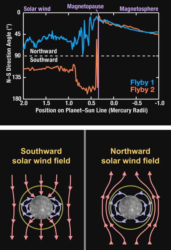
Also, the geometry of the solar wind was different this time around. On the first flyby, the direction of the magnetic field imposed by the solar wind was northward. On the second flyby, the direction was southward. Yet the field strength was similar between the two flybys. Deputy project scientist Brian Anderson explained that when the solar magnetic field was directed northward, it matched Mercury's, so there was very little interaction between the solar wind and Mercury magnetic fields. However, the situation was quite different during the second flyby. With the solar wind magnetic field directed southward, magnetic field lines from the solar wind field connected directly to field lines from Mercury, tightly coupling the Mercury and solar wind magnetic fields, giving the solar wind "direct access" to Mercury's north pole. "The total energy transfer into [Mercury's] magnetic field is equivalent to 100 medium-sized power plants," Anderson said.
Despite the "profound" difference in the geometry of the solar wind magnetic field, its connection to Mercury, and in the flyby geometry, MESSENGER measured the strength of Mercury's magnetic field to be nearly identical -- agreeing to within two percent -- between the January and October flybys. Anderson explained that this means Mercury's magnetic field is nearly centered on the planet's rotational axis, and that its orientation is "tightly aligned" to the rotation axis, within two degrees. By comparison, Earth's magnetic north pole is offset from its rotational axis by 11 degrees, and the magnetic pole wanders with time.
Surprises in the Exosphere
Finally, participating scientist Ron Vervack presented results from the Mercury Atmospheric and Surface Composition Spectrometer (MASCS) instrument, which studied the tenuous atmosphere of Mercury by looking for the spectral lines of chemical elements. MASCS detected both sodium (with its diagnostic pair of spectral emissions at yellow wavelengths) and calcium (which has an emission line at a blue wavelength), both of which had been detected from Earth before. But the two had not before been detected simultaneously, and MESSENGER demonstrated the value of simultaneous detection.
The map of sodium in the exosphere of Mercury, which trails behind the planet from the Sun in a long "tail," contains two regions of maximum abundance, at high latitudes, well above and below the equator. By contrast, the map of calcium has one maximum, located above the equator. Why the two elements have such different distributions is a mystery, Vervack said. "The difference in distribution is related to the process that's releasing things from the surface," so it seems likely that different processes cause the release of sodium and calcium.

In the upper part of this figure, two histograms represent typical observations in the tail region of Mercury's exosphere from calcium (left) and sodium (right) atoms. Known as "spectral lines," these emissions have been scaled to approximately the same peak level for ease of comparison; however, the sodium emission is much brighter than that of calcium. Each emission occurs at a unique wavelength, with that of sodium in the yellow part of the visible spectrum and that of calcium in the blue part. The sodium emission is actually two very closely spaced emissions that are usually termed the D lines of sodium. The peaks of the two emissions are just separated (indicated by the D2 and D1 labels) in the figure. These are the same emissions that produce the yellow glow in sodium vapor lamps often used in street lighting.
The middle image of this figure shows the spatial distribution of sodium emission, which extends away from the planet in the anti-sunward direction. In the image, north is up and the Sun is to the left. The sodium emission shows two broad peaks that are located close to the planet to the north and south, and there is less emission near the equatorial region. The bottom image shows the spatial distribution of calcium emission. In contrast to the sodium emission, the calcium emission is mostly symmetric about the equatorial region and less bright near polar regions. The spatial variations between the calcium and sodium distributions indicate that the processes controlling these two species are likely different.
Image: NASA / JHUAPL / CIWAnother significant accomplishment for MASCS was the first-ever detection of magnesium in Mercury's exosphere. Magnesium's diagnostic emission lines are in ultraviolet wavelengths; ultraviolet radiation is effectively screened out by Earth's atmosphere, so the detection is impossible by Earth-based instruments. The presence of magnesium was expected, but it had not been detected until now.
Vervack said that, because of the limitations of Earth-based instruments, "until now, people have always referred to it as the 'sodium tail' of Mercury." With MESSENGER's detections of calcium and magnesium, that usage will probably go out of fashion, and scientists will just refer to it as Mercury's tail. And that tail is a dynamic feature of Mercury; it has changed noticeably since MESSENGER's first flyby. "The surface is ancient, but the exosphere and magnetosphere are changing on time scales of days, hours, minutes, even seconds," Vervack said.
MESSENGER's long journey includes one more flyby on September 29, 2009; that one will have a geometry nearly identical to the October 2008 one. Then MESSENGER has to circle the Sun almost another four times before it finally settles into Mercury orbit on March 18, 2011.
The Time is Now.
As a Planetary Defender, you’re part of our mission to decrease the risk of Earth being hit by an asteroid or comet.
Donate Today

 Explore Worlds
 Find Life
 Defend Earth

