
 Explore Worlds
 Find Life
 Defend Earth


Mars Exploration Rovers Update: Opportunity Gets Back to the Past at Winter Site
Sols 3444 - 3473

Written by
A.J.S. Rayl
Contributing Editor, The Planetary Society
November 4, 2013
Mars Exploration Rover
NASA / JPL-Caltech / Maas Digital
As fall began to give way to winter at Endeavour Crater, Opportunity cruised deeper into her campsite on the western side of Solander Point in October, heading for a site that may contain clay minerals and the rover's next big discovery, and the Mars Exploration Rovers mission trekked another month closer to its 10th anniversary in January 2014.
"Winter is coming. Opportunity is doing great," said Steve Squyres, the MER principal investigator, during an interview at month's end, from his office at Cornell University. It had been another good sol and it ended another good month on Mars.
The veteran rover spent the first week of October at the base of the northwestern flank of this remnant section of Endeavour's eroded rim, checking out the ridge that defines it and taking a new mission panorama that will be released in coming weeks. After finishing its imaging assignment, Opportunity headed up onto the ridge and drove back to the past, crossing onto ancient terrain that dates back to the Noachian Period, 3.7 to 4.2 billion years ago when Mars was warmer and wetter and more like Earth.
"We're Martian mountaineering," said John Callas, MER project manager at the Jet Propulsion Laboratory (JPL), home to all the NASA Mars rovers. "That's a little bit of a hyperbole, but we are going up onto the ridge."
Opportunity drove straight to a north-facing slope, where it could angle its solar arrays to the Sun in the northern sky, and at the same time check out an outcrop, called Kangaroo Paw. We've never climbed a hill like this with Opportunity," said Squyres. "We've climbed out of craters before, but this is the first mountaineering we've ever done with this rover."
The Mars Exploration Rover seems to be taking to it like, well – a duck to water. "She's doing well and we've had no new problems," reported Bill Nelson, chief of the MER engineering team at JPL.
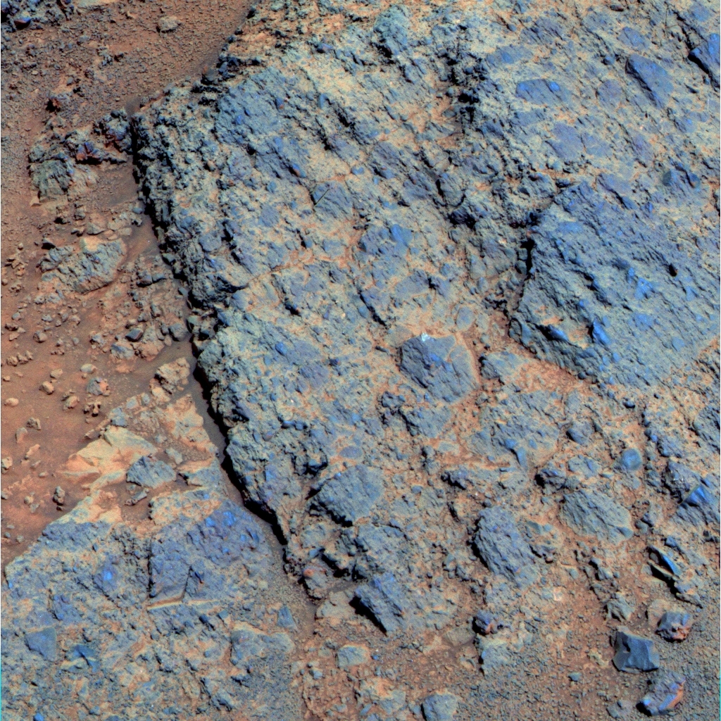
Kangaroo Paw
NASA / JPL-Caltech / Cornell / ASU
Opportunity got back to the past in October as she roved up onto the ridge that runs through the Solander section of Endeavour Crater's rim and back onto the ancient rocks that date back some 3 to 4 billion years ago when Mars was warmer and wetter. The rover took this image with her panoramic camera (Pancam) on her Sol 3458 (Oct. 15, 2013) and the Pancam team processed it in false color to better see the differences in its make-up and texture.From Kangaroo Paw, Opportunity moved on to another slope and another outcrop and then another, winding its way across and down the ridge. "We're exploring the outcrops on the western flank of the ridge, heading south/southeast from the northern tip," said Ray Arvidson, MER deputy principal investigator, of Washington University St. Louis. So far, they all look like breccias, he said of the inspected outcrops, likely hurled up from whatever impact caused the formation of the crater all those billions of years ago.
From Opportunity's panoramic view, the ridge – which is effectively everything south of the tip of Solander Point – appears big, but subtle, its secrets covered in sand and soil, its full reach invisible from view. But with the rover's first climb up and onto the ridge's slopes, and the next several drives across familiar old terrain, the MER scientists seem to sense surprises are lurking here, different geologic formations that may look familiar or may be completely Martian, and the rover is already on its way to one possible new finding.
While Opportunity is hiking up slope toward the east, the rover is generally being directed to the south. The robot field geologist is following the ridge to the team's hoped-for winter destination, an area of outcrops about 200 meters to the south of its position at the base where it shot the new mission panorama. That's where an instrument onboard the Mars Reconnaissance Orbiter (MRO) detected clay minerals – and clay minerals would be more evidence of water, probably flowing water, a lot like we know it on Earth – and following the water is what this rover was meant to do.
Opportunity suffered a loss of energy in October as the Martian winter began to set in, but the loss was within expectations. In fact, everything – from the dust levels in the sky and on the rover's solar panels to the power levels – is tracking with the latest winter predictions and the team still expects the rover will be mobile throughout the season. "While we'll have to kind of sharpen our pencils, so to speak, we should be able to continue until spring," assured Nelson. The MER operations team is now charting the rover's path to the south along a route that enables it to move from one north-facing slope to another, known as the 'lily pad' technique. On these little slopes, the rover can stop, rest, angle its solar arrays directly to the Sun (which rises and sets low in the northern sky during winter) and stay power safe on these slopes during the harsh season. "We're definitely in lily pad hopping mode," said Ashley Stroupe, rover planner at JPL. "We've been able to find good lily pads near interesting stuff, and it's going as we had hoped."
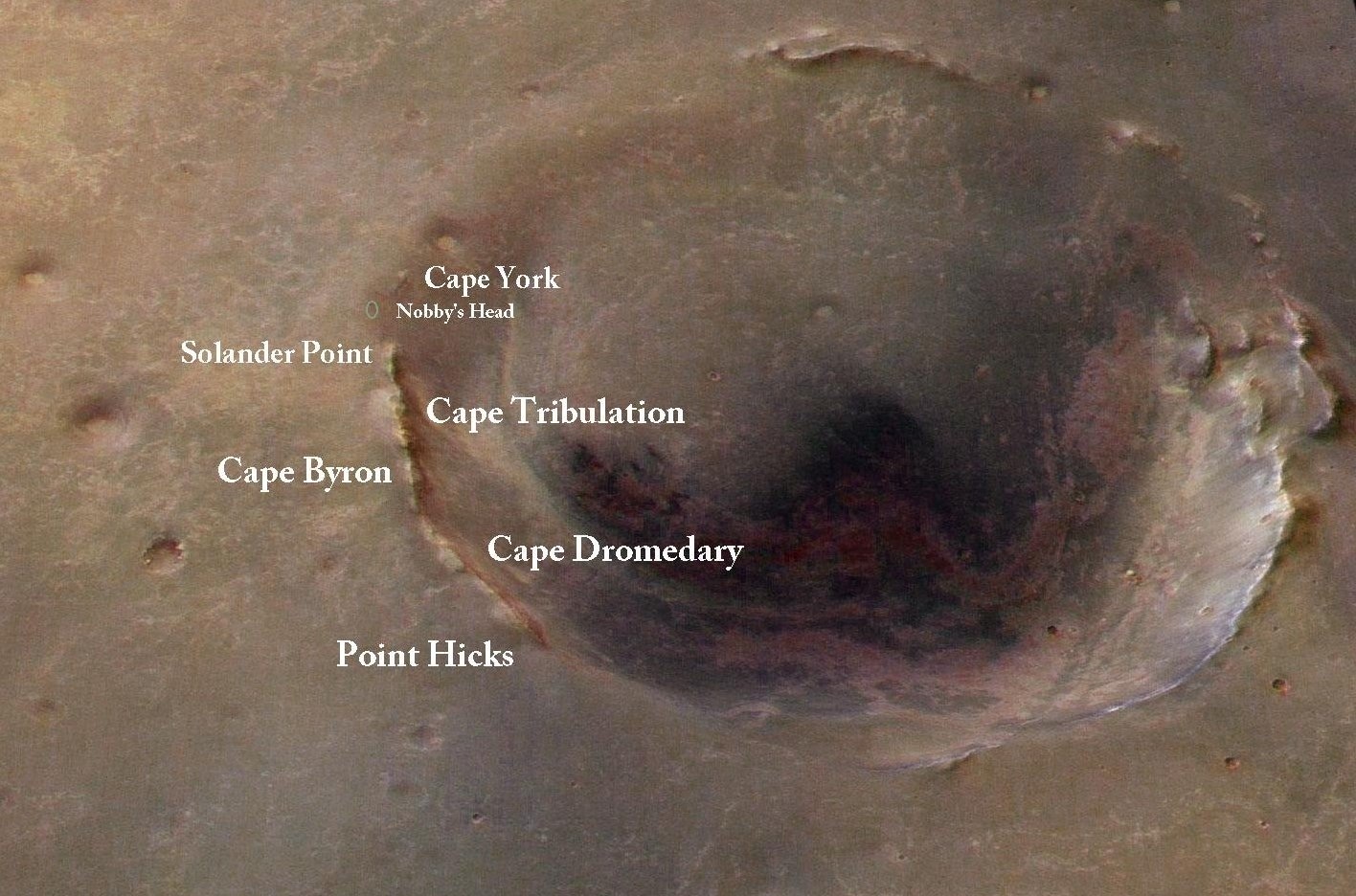
Overview of Endeavour Crater
This image, taken by the University of Arizona's HiRISE camera onboard the Mars Reconnaissance Orbiter, shows the sites where Opportunity has been and is going. It was colorized and labeled by MER poet Stuart Atkinson, of UnmannedSpaceFlight.com, a frequent contributor to the MER Update. Atkinson has been following Opportunity's path to Endeavour in his blog called The Road to Endeavour, which you can visit here: http://roadtoendeavour.wordpress.com/NASA / JPL-Caltech / UA / S. Atkinson
Every stop of the way in October, Opportunity took more pictures with her stereo panoramic camera (Pancam) and her navigation camera (Navcam). In these pictures, the members of the MER team on Earth look for slopes with 5 to 20-degree northerly slopes –"juicy slopes," as Scott Lever, MER mission manager, put it – near interesting targets where the robot field geologist can warm her wheels.
So far, so good. Although Opportunity is "feeling" the colder temps, "the rover is still in a good situation, and we're pushing on using our strategy of driving from lily pad to lily pad," said Callas.
As the terrain goes, this rover, so far, has seen it all before. "Right now we're seeing familiar sorts of geology that we saw over at Cape York, though there are clues that as we work our way higher and higher and to the south, we'll start to get into different things," said Squyres.
What those different things might be, no one knows or is willing to say – yet. But the scientists, in particular, are looking forward to being surprised . . . and with Christmas coming, the timing is perfect.
If all goes as planned, Opportunity will continue trekking south to hunker down in the clay mineral hunting grounds sometime in November for an extended scientific investigation during the depths of winter, maybe through the winter solstice which occurs around February 14, 2014. Once again on this mission, as the world begins to wind down after another year fraught with troubles, as well as good deeds that never see the light of the media, Opportunity is stepping up her game and the scientific anticipation is building.
"We're heading south toward that clay signature and what we'll find when we get there, we don't know," Squyres said. "But there was a less prominent clay signature back at Matijevic Hill and we found so much diversity and interesting, crazy things, I'm not even going to try and guess what we're going to find at this spot."
Although Spirit's mission was declared over in 2011, Opportunity seems to have tried to carry on with enough spunk for the both of them. "We've had a few hits over the years – the stuck 'on' heater, the [stiff] front wheel, the [broken] shoulder [joint], but these are things we've been living with for years in all cases," said Lever. "Other than those, the rover is actually quite healthy, and it keeps on trucking."
As October turns to November, the push for Opportunity to get south is on. "We want to be in the clay hunting grounds in November, so we have enough time to drive around and pick out the choice spots for winter campaign sites," said Arvidson.
Meanwhile, down on Earth preparations are being made for MER's next big anniversary. In January 2014, Opportunity and MER will cross a once impossible milestone – 10 years of surface operations.
Spirit landed around 9:35 pm, January 3, 2004 Pacific Standard Time, [4:35 am Ground UTC, January 4, 2004], and Opportunity followed January 24, 2004. Those days will be primary celebration days for the 10th anniversary and The Planetary Society will be hosting events in cities across the country and around the world, as well as holding a celebration in coordination with NASA.
The MER milestone will also be celebrated throughout the month and into 2014 with exhibitions online, including at The Planetary Society's website. The ongoing mission will also be honored in real life at the Smithsonian National Air & Space Museum, which will open its MER exhibit in its building on the Mall, on January 3, 2014, an exhibit for which MER team members selected the images and offered scientific and engineering stories. Stay tuned and check out your local events calendars.
NASA / JPL-Caltech
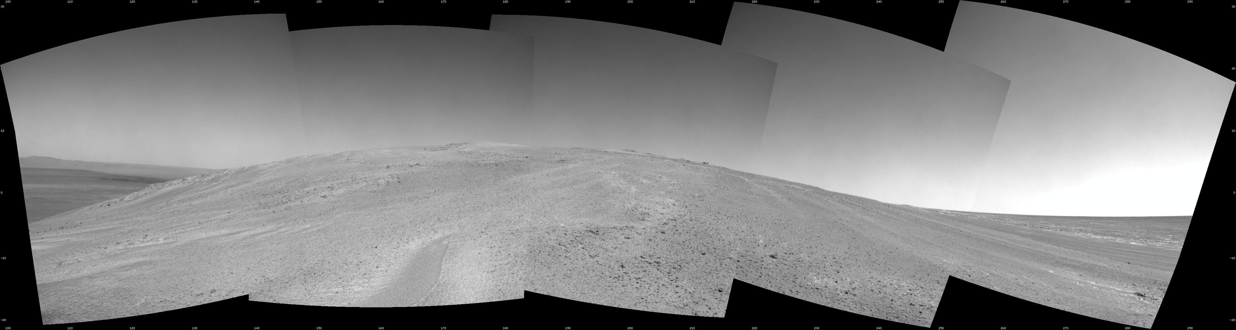
Back to the past
Opportunity captured this uphill view with her Navigation Camera (Navcam) after beginning to ascend the ridge at the northwestern slope of Solander Point, located along the western rim of Endeavour Crater. The view combines five frames that the rover took on her Sol 3463 (Oct. 21, 2013). She began climbing the hill on Sol 3451 (Oct. 8) and completed three additional uphill drives before reaching this point. The scene extends from east-southeast on the left (with a glimpse across Endeavour Crater) to west-northwest on the right. It is presented as a seam-corrected cylindrical projection.Opportunity from Meridiani Planum
When October dawned at Endeavour Crater, Opportunity was positioned over Callitris, a flat, light-toned rock located at the geological contact between Solander Point and the Bench that surrounds Solander Point.
The sky over Endeavour was still pretty hazy with the Tau or atmospheric opacity registering around 0.633 the first sol of October. The rover's solar array dust factor continued its steady deterioration, as expected during winter, reading 0.494. But Opportunity was still producing 323 watt-hours of energy, plenty enough to rove and work.
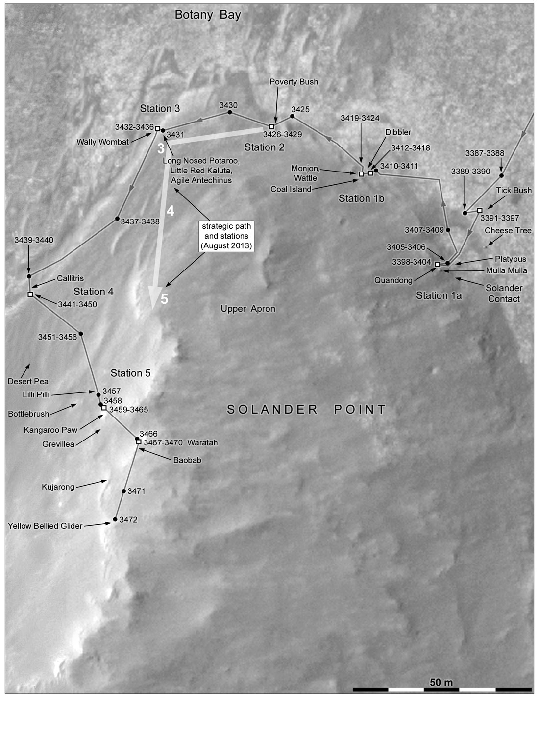
Opportunity's route
Phil Stooke, author of The International Atlas of Mars Exploration, has been charting Opportunity's route around Solander Point. In October, as he detailed here, the rover went up onto and along the ridge that runs through this section of Endeavour Crater's eroded rim.Phil Stooke, University of Western Ontario
As it turned out, the pictures the robot field geologist tried to take of the comet ISON during the last weekend in September didn't turn out. Not so much as a smudge was to be found. "The comet did not make itself bright enough to be visible to the stereo camera," according to JPL mission reports.
The robot field geologist turned her focus to Callitris on Sol 3444 (October 1, 2013), pulling out her Rock Abrasion Tool (RAT) and brushing a spot on the outcrop, then switched to her Microscopic Image (MI) to take the pictures for an up-close mosaic. As per the study protocol, the rover then placed her Alpha Particle X-ray Spectrometer (APXS) on the spot for an overnight integration or analysis to determine its chemical make-up.
Truth told, Callitris was "a target of opportunity" for Opportunity, said Arvidson. The team was commanding the rover into this position at the boundary or geologic contact between Solander Point and the Bench or apron area that surrounds it, so she could take the pictures for the mission's next panorama. Starting on Sol 3446 (October 3, 2013), the rover did just that, spending the next two sols taking the extensive stereo color panorama of the ridge that, for all intents and purposes, is Solander Point.
Opportunity devoted the rest of the first week of the month to collecting additional measurements of Callitris with the APXS. From that data, the MER scientists concluded the outcrop is Burns Formation, Arvidson informed, essentially the same terrain that the rover spent some seven a half years roving across to get to Endeavour Crater.
With 38.41 kilometers (23.87 miles) on her odometer, Opportunity took off on Sol 3452 (October 9, 2013), heading to the southwest. The rover logged 19.5 meters (64-feet) and ended the drive on a sunny slope or lily pad.
The plan, as reported in the last MER Update, was for the rover to head south to outcrops where the Compact Reconnaissance Imaging Spectrometer for Mars (CRISM), which is searching for past and present signs of water, detects the signature for clay minerals. A visible-infrared spectrometer aboard the Mars Reconnaissance Orbiter, CRISM first detected the signature for phyllosilicates, specifically a group of clay minerals known as smectites in various places along Endeavour's eroded rim, in 2008.
Callitris
Opportunity began the month of October perched over a light-toned flat rock the team dubbed Callitris. After brushing it with her Rock Abrasion Tool (RAT), the robot field geologist worked to glean its chemical composition with its Alpha Particle X-ray Spectrometer (APXS). Turns out, it is Burns Formation, informed Ray Arvidson, MER deputy principal investigator, or, in other words, much like the stuff over which Opportunity traveled for some 7.5 years before reaching Endeavour. The rover took this picture with her Pancam following her examination.NASA / JPL-Caltech / Cornell / ASU
Arvidson, who is also a co-investigator on the CRISM team, did some additional work with the infrared spectrometer and zeroed in specific locations at Matijevic Hill in August 2012. Several months later, Opportunity ground-truthed those clay minerals at rocks dubbed Whitewater Lake and Esperance, on Matijevic Hill at Cape York, the first segment of Endeavour's eroded rim that the mission visited.
Now, at Solander, Arvidson has done similar work to tighten the perimeters of the CRISM detection to this area of outcrops to the south of Opportunity's present location. The team would keep to its plan. "The idea is to work the outcrops we come across driving to the south to where CRISM, we think, detects the clay signature," Arvidson said.
While Opportunity soaked up sunlight fuel, she snapped some color Pancam pictures and collected an atmospheric argon measurement with the APXS on Sol 3453 (October 10, 2013), then spent the next three sols shooting more images, conducting more remote sensing, and recharging.
The robot field geologist wrapped up the second week of October with a 23.5-meter (77-foot) drive to the south on Sol 3457 (October 14, 2013) that took it up the ridge toward the next target, an outcrop named Kangaroo Paw.
The following sol, Opportunity began the third week of October with a 3.5-meter (11-foot) southeasterly bump towards Kangaroo Paw on Sol 3458 (October 15, 2013), then made a 60-centimeter a (24-inch) bump to put the surface science targets within reach of her Instrument Deployment Device (IDD) or robotic arm.
On Sol 3460 (October 17, 2013), the robot field geologist conducted an in-situ or close-up, contact investigation of Kangaroo Paw. First, she pulled out her RAT to brush the surface target and then, following protocol, placed the APXS down to glean its chemical composition. The next sol, 3461, the rover took MI pictures for a mosaic and then followed it with another APXS integration, (October 18, 2013), which she continued for the next several sols.
As October progressed, the skies remained hazy mid-month, with the Tau fluctuating between 0.649 to 0.685. Although the Opportunity's solar array dust factor was also fluctuating and the dust continued to accumulate, the rover was still producing upwards of 325 watt-hours of power, a very workable level for winter.
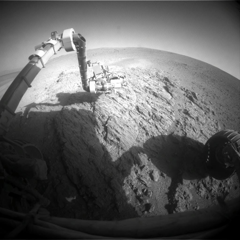
Working at Kangaroo Paw
After roving up onto the ridge at Solander, Opportunity got to work on Kangaroo Paw, before moving on to other outcrops near north-facing slopes where the rover could angle her solar arrays toward the Sun and soak up as much sunlight energy as possible as winter "blows" in. From the first analyses, the rover team found that the robot field geologist had gotten back to the past when it reached Kangaroo Paw, which turned out to be one of ancient rocks of Endeavour's rim.NASA / JPL-Caltech
When the last week of October began, Opportunity was taking Pancam and Navigation Camera (Navcam) and wrapping up work at Kangaroo Paw. "Then we went a little more to the south to the next outcrop," said Arvidson.
On Sol 3466 (October 23, 2013), the robot field geologist continued the hike along the ridge, driving southeast for 12.5 meters (41 feet) toward a rock outcrop the team nicknamed Waratah. After the drive, the rover took an atmospheric argon measurement with the APXS for the mission-long study of Mars' atmosphere.
The initial baseline stereo image that Opportunity had taken of her winter campgrounds back in September gave the ops team the first solid ground-truth for mapping lily pads and it helped them home in on the first several north-facing slopes where the rover rested her wheels, Stroupe said. With the lily pad technique, the robot field geologist was maintaining favorable northerly tilts during the rest stops, allowing her to keep roving and working.
On Sol 3467 (October 24, 2013), Opportunity bumped 1.3 meters (4.3 feet) toward outcrop nicknamed Waratah. The next sol, the rover used her MI to take the needed pictures for a mosaic of a surface target there, dubbed Baobab. Then, as usual, the rover placed the APXS on the same for a multi-sol integration. "We finished Baobab that weekend and planned a 30-meter drive for Sol 3471 (October 29, 2013), continuing to the south, working those outcrops," said Arvidson.
From the initial analyses, Kangaroo Paw and Waratah are Shoemaker Formation. "They all look like impact breccias," said Arvidson, "likely stuff thrown out from whatever created Endeavour Crater."
"We are on good, solid, pretty steep north-facing slopes and have worked over several outcrops so far along the crest of the ridge, and they've all been Shoemaker Formation," confirmed Squyres. "They are essentially dead-ringers for rocks like Amboy that we saw way back at the north end of Cape York, and rocks at the north end of Shoemaker Ridge, and at Greeley Haven."
Opportunity continued the journey south along the ridge on Sol 3471 (October 29, 2013), driving about 29 meters (95 feet) as she headed toward another convenient lily pad. Following the drive, the rover took the usual Pancam and Navcam panorama pictures.
On the following sol, 3472 (October 30, 2013), the rover continued driving with a 10-meter (nearly 33 feet) drive toward another energy lily pad and a location called Yellow Bellied Glider, where she stopped for a rest, with 38.51 kilometers(23.93 miles) on her odometer. She needed it.
Although "mountaineering" was something new for this rover, Opportunity managed to put a tenth of a kilometer (100 meters or about 328 feet) on her rocker bogie in October, and maintain power levels above 300 watt-hours managed right up to the end of the month. But as All Hallow's Eve descended on the Earth, the rover's energy dropped to 299 watt-hours. It was the first time since winter had been on the horizon that her energy dropped below 300 watt-hours.
Opportunity's energy is "still okay," reported Callas. "We're pretty much where we've estimated we would be at this point. We'd like to be better, of course, but we're where we're expecting to be."
"If we continue to maintain this 15 to 18 degree tilts we've been finding for lily pads, the levels will be under 300 watt-hours, but we'll still be in the regime where we can do these small bumps and head to other lily pads, so the rover should be fine," added Stroupe.
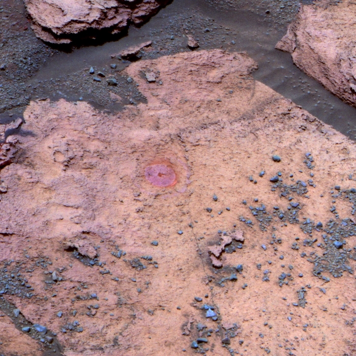
Trick or Treat?
Opportunity took this picture with her Pancam on Halloween. We have no idea what it is, but it may be the rover is already getting into some of those "different things" the MER P.I. Steve Squyres sensed the team would find. Stay tuned.NASA / JPL-Caltech / Cornell / ASU
The general plan is for Opportunity to find the best likely places for the clay minerals in the outcrops to the south so the MER scientists can outline a winter campaign – if that's possible. "We're trying to get to that southerly spot the place where CRISM seems to be detecting the clay signature in November, to give us enough time to drive around and do a walkabout like we did on Matijevic Hill," said Arvidson. "We'd like to find the choice spots to settle in for winter for detailed campaign measurements."
The signature appears to be coming from a fracture that cuts through the Burns Formation and into this section of Endeavour's eroded rim, an area they're calling the Hinge Line. "That's where I'm seeing evidence for water alteration to produce clays," Arvidson said. "It looks like that fracture extends into Solander Point, and that's where you'd expect boxworks like we found at Esperance, places where you have big fractures [caused by] higher water flow because there is more permeability. That's the idea," he said. "But it could be totally bogus," Arvidson cautioned. "The instrument could be torquing us around and it could not be a fracture and there could be nothing there. But it gives us an hypothesis to test and a target to examine."
There may be plenty of phyllosilicates higher up and deeper in the ridge on the inboard side of the ridge. "But here's the problem: the whole area is tilted into toward Endeavour, and then the inboard side of the ridge is even at a higher tilt away from the Sun," said Arvidson. "And when you're away from the Sun, you have less solar energy reflected and you have lower signal-to-noise, and so clay minerals could be there, but I can't detect them. What I can detect easily with CRISM is the signature on the Sun facing side."
Arvidson thinks the clay minerals that Opportunity might find in this area of outcrops off the ridge are smectites that typically form in microscopic crystals, generally known as montmorillonites, like those found at Esperance. Though still a smectite like the clays ground-truthed in Whitewater Lake, it contains more aluminum than the Whitewater Lake clays.
Without the use of her mineral detecting Mini-TES and Mossbauer instruments, of course, the MER scientists don't actually know the mineralogy of Esperance or Whitewater Lake, but they do know the chemical compositions. "The composition of Esperance points to a montmorillonite; whereas, the clay mineral we found on Whitewater Lake, the veneers, are a different kind of iron-rich clay called a nontronite," Arvidson clarified.
What does montmorillonite mean in terms of water? "It means more water," said Arvidson. "With basalts, if you have a little bit of chemical corrosion, nontronites can from. If you have more corrosion, where iron and other species are being removed, then an aluminous-rich clay called montmorillonite is produced. And if you have a hell of a lot of corrosion, it goes all the way to a highly aluminous clay called a kaolin, which we have not found," he explained.
If Opportunity does find montmorillonite here at Solander, it would not only indicate more substantial water alteration than Opportunity found with the dark veneers or splotches of clay on Whitewater Lake, but in all probability fill out the story of what wet environment was once here. "Until we get there and get the actual composition and the geologic setting, all we can say about the water is that it was probably neutral to mildly acidic," Arvidson underscored. "It certainly was not the low acidity water that generated the sulfate sandstones in the Burns Formation, and that is consistent with the water being less acidic in earlier times."
Arvidson is not ready to release the CRISM spectra yet, and there is no guarantee the rover can get there before winter takes hold. "We don't have a good tilt map of the exact spots yet, so at this point we're not sure we can get to those outcrops during winter, because we're not sure if they have northerly tilts to sustain the rover," said Stroupe. "We are still a ways from it."
However, the plans for Opportunity to try and get to these outcrops and to rove throughout the winter season for now remain the same. "We probably will have mobility to go from one spot to another spot to another spot," said Arvidson. "That is our objective," confirmed Callas.
As Opportunity heads deeper into the ridge, it is going back to the pastas it roves onto ancient rim materials. "We're done with the Burns Formation and done with Grasberg, and we're again looking at the ancient rim materials," said Arvidson. "Our journey will be governed by the fact that we have to stop on lily pads if we want to do anything decent, in terms of power consumption like detailed imaging or deploying the arm, but we are continuing the exploration."
Whatever the MER team finds in the clay hunting grounds is likely to be enlightening. "Remember all the adventures and discoveries we found Matijevic Hill," said Squyres.
Once Halloween finishes spooking little monsters around the world, Opportunity will continue hopping from lily pad to lily pad, following the ridge, and working her way south to the clay mineral hunting grounds. "We're doing detailed lily pad maps at every stop, to try to pick the best places to stop," said Stroupe. "Our progress will slow down a little bit, because we're going to be driving a little less, as a result of power. Hopefully, we can find some good northerly tilts in these regions where we see the CRISM data so we can check those out during in the winter."
The outlook for the rover is as bright as could be expected too. Although truths are always temporary on Mars, at the moment Opportunity's sixth Martian winter is looking to be "like Spirit's first winter," said Stroupe.
Still, one thing that has not changed since Sol 91 is this: every day is a gift. "It's been almost 10 years, so there are no guarantees," reflected Squyres. "Right now, the vehicle is doing great and the team is at the top of their game, and it's really going well. We will see how it goes tomorrow."
NASA / JPL-Caltech / Cornell / ASU
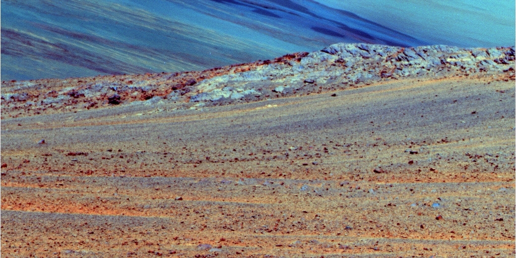
A view of Mars from the ridge
Opportunity used her Pancam to snap this image in mid-October. It shows the ridge that the rover is currently traversing, as well as other parts of Endeavour Crater. The Pancam team processed it in false color to better distinguish the different materials in view – and it seems to have taken on the look of a painting.Protect Our Shared Future
You help us defend humanity and prevent asteroid impacts. Donate now to become a Planetary Defender!
Donate