Emily Lakdawalla • Sep 09, 2015
Dawn Ceres image bonanza: Grab your 3D glasses!
All the time that I've been distracted by the New Horizons mission at Pluto, the other dwarf planet mission has been steadily, methodically sharing dozens of images of brand-new sights of a previously unexplored icy world. I'm talking about the Dawn mission to Ceres, of course, and for the last couple of days I've been making up for lost time, completely buried in the Dawn Ceres images that have been released over the last few months in NASA's Planetary Photojournal.
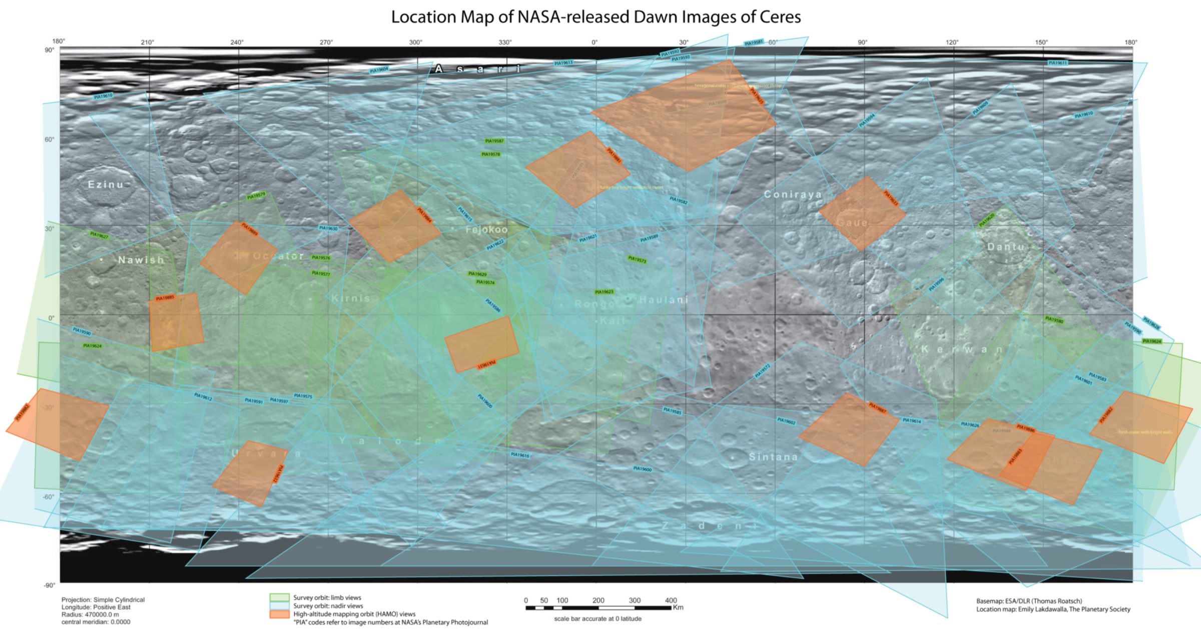
Lately, they have begun to release images taken from their High-Altitude Mapping Orbit (HAMO), just 1470 kilometers above the surface of Ceres. These images are super cool but because I haven't been paying close attention to the mission (distracted by Pluto!) I found it difficult to orient myself and understand the scale of the features. So, like any good geologist, I made a context map.
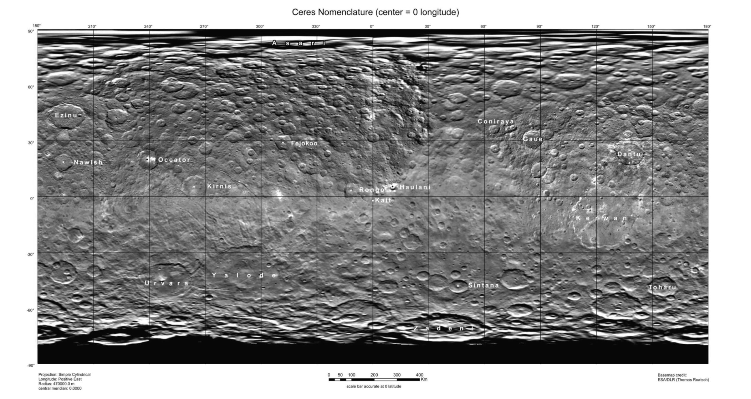
I began with this great map of Ceres that includes labels for the first craters to be named:

Named craters on this map include (from largest to smallest): Kerwan (284 km), Yalode (271 km), Urvara (163 km), Conirarya (136 km), Zadeni (129 km), Dantu (125 km), Ezinu (120 km), Kirnis (115 km), Occator (92 km), Toharu (88 km), Gaue (84 km), Nawish (79 km), Fejokoo (70 km), Rongo (68 km), Sintana (61 km), Asari (52 km), Haulani (32 km), and Kait (0.4 km). Tiny Kait marks Ceres' prime meridian.
Next, I looked at the more than 50 Survey Orbit images that have been released to date, and located their positions on the map. Now, if I were a Dawn researcher, I would have had access to mapping and geographic projection tools that could have automatically produced these footprints. I don't have access to either those tools or the necessary geometric information about image pointing, and anyway I don't need to be so accurate; I just need a pretty good location for the footprints so that I can identify which images overlap a feature that I'm interested in. So I just drew all the footprints as quadrilaterals. They're not perfectly accurate, but it's close enough for my needs. Once I had the Survey Orbit images located, I could dive in and locate the smaller footprints of the HAMO images -- with a lot of help from a similar map already produced by user "ZLD" at unmannedspaceflight.com. Et voilà:

While I was going through the images to make the map, I made lots of notes on Ceres' fascinating craters and other features. That discussion will have to wait for a later post. But one thing that this map enabled me to do more quickly was to identify locations that had been imaged twice from slightly different angles, allowing me to assemble 3D views. So grab your 3D glasses or cross your eyes or click the flicker-gif links and enjoy Ceres in 3D!
First, one of Ceres' splashier craters, Haulani:

Here's another, as yet unnamed and much smaller splashy crater:

Urvara crater has quickly become one of my favorite regions on Ceres:

But the spot with the best story to tell is this one, first noticed by some sharp-eyed folks at unmannedspaceflight.com, in the same images that contained the little unnamed splashy crater. In 3D you can really see the steepness of the crater wall, and the long runout of the landslide into the strangely hexagonal crater. (Ceres has a lot of those hexagonal craters.)

Now that I have my bearings on Ceres, I'll write more later about its strange landforms!
The Time is Now.
As a Planetary Defender, you’re part of our mission to decrease the risk of Earth being hit by an asteroid or comet.
Donate Today

 Explore Worlds
 Find Life
 Defend Earth

