
 Explore Worlds
 Find Life
 Defend Earth


Finding my way around comet Churyumov-Gerasimenko
Written by
Emily Lakdawalla
August 15, 2014
Rosetta has nearly completed its first funky three-cornered orbit around in front of the comet. ("In front of?" It's been pointed out to me that the spacecraft's motion isn't enircling the comet's center of mass, but is instead maneuvering around a point located sunward of the comet.) Each day we're getting views of the nucleus from more directions. There are amazing features everywhere, but it's really hard to orient myself on this crazy-shaped world, and that makes it hard to figure out whether I'm looking at the same thing from one image to the next. I figure other observers are having the same problem, so I thought I'd put together some images that will help all of us navigate around Rosetta's new home!
This effort would be a lot easier if features had names, but of course there are no official names yet; Rosetta only just arrived, and mapping this world will take time. It's tempting to run around naming features, but that seems a bit presumptuous, and would be counterproductive once official names come out. I have to do something, though, so I'll be using unique, descriptive words to identify a few of the things that stick out at me, and hopefully at some point in the future I'll be able to attach actual official names to some of these features.
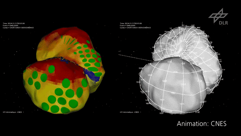
To begin with, let's orient ourselves to how this comet spins in space. The comet is made of a big lobe and a little lobe with a narrow neck between. The comet's spin axis is located at a point near where the neck connects to the big lobe. They have already defined a coordinate system for the comet, with the north and south poles corresponding to where the spin axis crops out of the nucleus. The big lobe is the zero-longitude end, and the little lobe is the 180-degree-longitude end. Take a look at how the coordinate system relates to the general shape of the comet in this animation:

Now, if you look at the left side of the animation, you'll see a multicolored picture of the comet. Ignore the green dots for now; just focus on the yellow and red patterns. Those colors signify how much of the time those parts of the comet spend being sunlit. Red parts are pretty much always sunlit. You can see that there are two sunny poles, one on each lobe, that are always sunlit. If some part is always sunlit, there's a corresponding part that's always in shadow. Much of the comet above 30 degrees north is always sunlit. Therefore, we don't ever see much of the comet below 30 degrees south latitude.
So, one thing I've learned from looking at the animation is that for the most part, if I take any photo of the comet and rotate it so that the light appears to be coming from above, I will usually have oriented it so that north is approximately up. The only time this doesn't work is when the view from Rosetta is looking down onto the north pole.
Of course, as I surveyed the recent NavCam images, I realized that many of them are actually looking at a polar view. Here's a montage of all the recent NavCam images from this first orbit. The top row are approximately polar views, so I've oriented them all to have the little lobe (and 180 degrees longitude) toward the top. The bottom row are a little more oblique, so I've oriented them to have north approximately up, as best as I can figure it. (I'm waffling about which row I should've put the top right image in....)

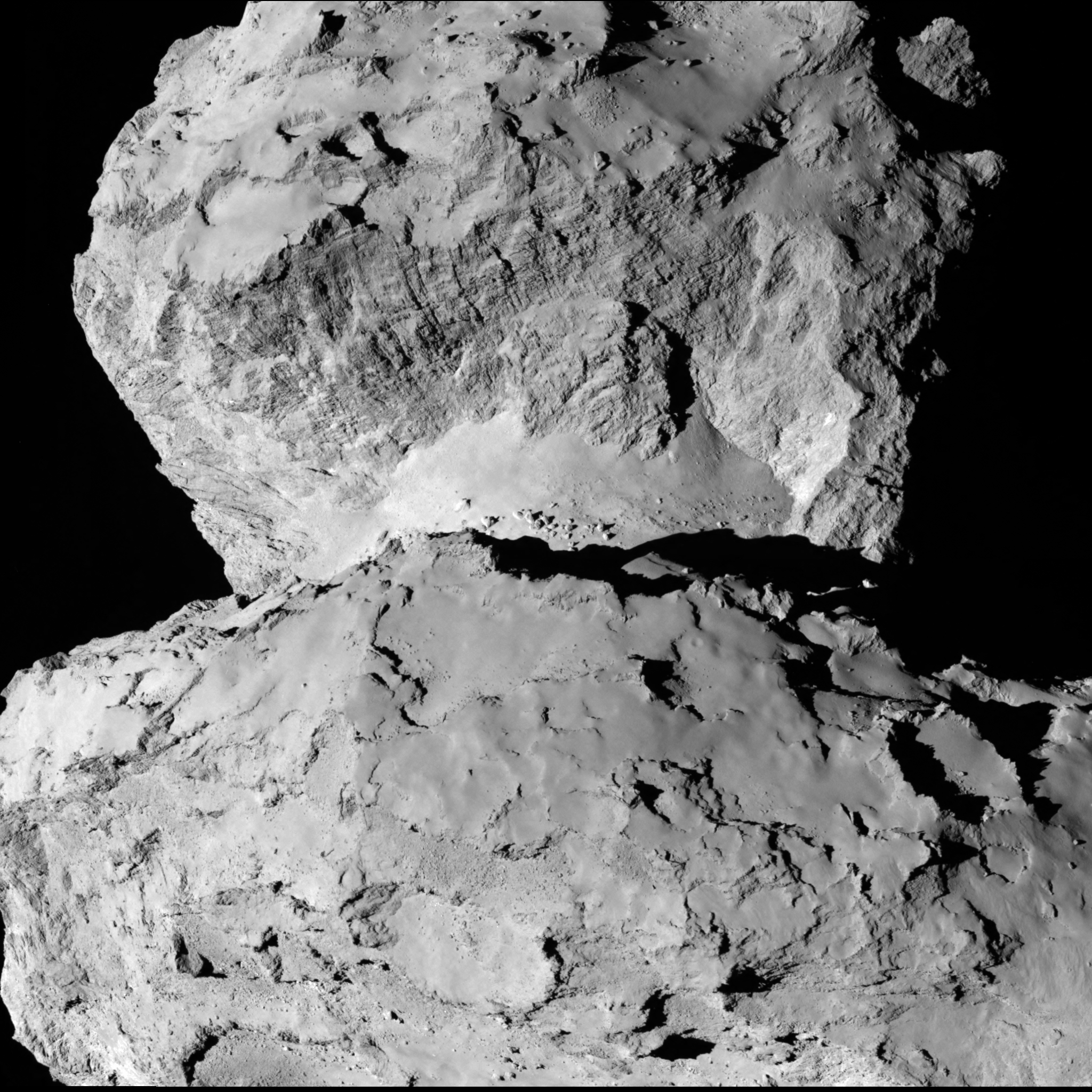
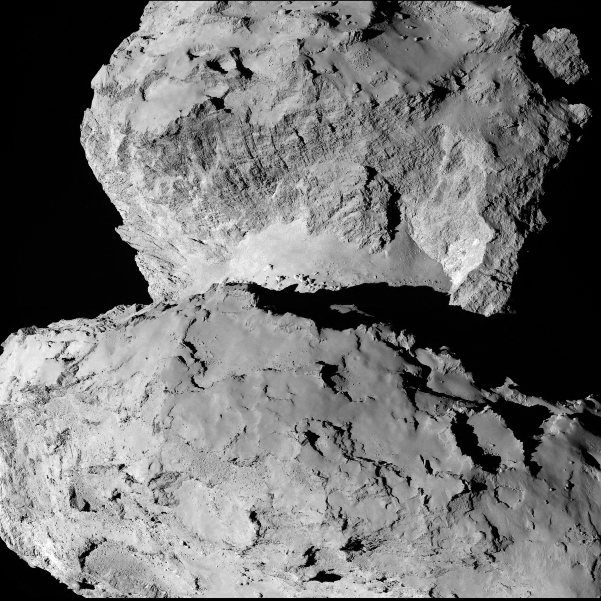
Now that I'm a bit more oriented, I can take on the latest image that they released from the OSIRIS camera yesterday. Actually, it's a pair of images, a left and right stereo pair. This is the first Churyumov-Gerasimenko image I've seen that fills the full OSIRIS camera frame. OSIRIS has the biggest detector of any framing camera flying beyond Earth right now: it's a 4-megapixel camera, each image being 2048 pixels on a side. Grab your red-blue glasses to enjoy the 3D view, or just enjoy the left-eye or right-eye image.

What are we looking at here? We're looking across the big lobe toward the small lobe. The north pole is tilted a bit toward the left.
I see three distinctly different kinds of terrain. First, there is a very, very smooth terrain. To my eye, it looks like a mantle that obscures something underneath. In one spot, I notice what looks very much like an impact crater in it. I could talk myself into believing that there were other impact craters present, whose edges have been blurred or degraded somehow.
In some places, there are fields of boulders. There's one particularly striking field of boulders on the neck. I said I wasn't going to give anything but descriptive names to these things, but the way it lines up as a bunch of beads around the neck, I'll probably never think of this boulder thing as anything but the "necklace."
You can see it in several of the NavCam images, too -- an incongrouous group of oddly vertical ricks. In some places they look like they're sitting atop the otherwise smooth terrain of the neck; in other places they seem to be slightly mantled by it, emerging from it.
But the terrain that keeps drawing my eye is what you see beyond the neck, on the side of the little lobe that faces inward toward the neck. It's striated, or stripey. I wouldn't call it layered. But it has a distinct fabric to it, a preferred orientation of little ridges and chasms. Possibly more than one set of intersecting fabrics. You can see the striated fabric keep popping out in the steep walls and ridges that crop out of the smoother terrain up on the sunny pole of the little lobe beyond it. That fabric has formed in a material that's coherent enough to hold together into scarps that make fascinating silhouettes against black space.
Here's a more distant view, from NavCam.
Elsewhere on the comet, there are quite a few features with raised, round rims. Suspiciously round. It's hard for me to imagine how you can make such raised, round rims by any mechanism other than impact cratering.
But if these are impact craters, a lot has happened to them since they formed. Check out this funny feature on a stalk cropping out of the rim.
What fun! Beginning on Sunday, Rosetta will transition to a slightly lower orbit, at around 80 rather than 100 kilometers, and it will spend the rest of August surveying from that altitude. Here's a timeline of the upcoming events. Stay tuned for more great photos!
- First triangular "orbit" averaging 100 km, August 6 to 17
- August 6: arrival, begin first leg
- August 10: begin second leg
- August 13: begin third leg
- August 17-24: transfer to 50 km
- August 20: turn at 80 km
- Second triangular "orbit" averaging 50 km, August 24-Sep 3
- August 24: begin first leg
- August 27: begin second leg
- August 31: begin third leg
- September 3-10: transfer to global mapping orbit at 30 km
- September 10-24: global mapping at 30 km
- September 24-29: night excursion and transfer to 20-km orbit
- (September 25: announcement of landing site selection?)
- September 19-October 10: close observations at 20 km
- October 10- : close observations at 10 km
- November 11: Philae lands
After all this staring at the comet, and someone on Twitter sending me a cartoon of what he thought the nucleus looked like, I couldn't resist it any more; I had to sketch out the creature I've been seeing emerge from the pictures. Enjoy.
Not sure what kind of monster Churyumov-Gerasimenko is, but it's kind of cute. Bulldoggy-gopherish thing. pic.twitter.com/iMQDjTjoFO
— Emily Lakdawalla (@elakdawalla) August 15, 2014
The vast majority of commenters on Twitter agree that it is actually this South American rodent:
@MidnightPlanets @elakdawalla Capybara! pic.twitter.com/WJ2pRbFB5b
— Kristin Block (@MarsMaven) August 15, 2014
Protect Our Shared Future
You help us defend humanity and prevent asteroid impacts. Donate now to become a Planetary Defender!
Donate