Emily Lakdawalla • Apr 11, 2014
Curiosity update: Initial reconnaissance of the Kimberley, sols 585-595
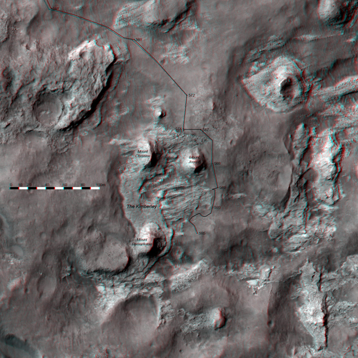
It's been a couple of weeks since I checked in on Curiosity. The rover has been busy, finally driving around the corner to sight the Kimberley for the first time. The Kimberley is a spot of well-exposed rocks that the Curiosity mission identified many months ago as being the best science stop on the way to Mount Sharp. What makes the Kimberley special? Here, have a 3D context map to appreciate it. The map isn't quite perfect -- I need to fiddle with the path a bit more to make it appear to sit properly on the topography -- but it's still pretty neat to see in 3D, with appropriate eyewear.

You can see three or four distinctly different expressions of rock exposed at the Kimberley. What Curiosity saw upon arrival at Kimberley is this Striated Unit, which you can see from orbit has a stripey appearance with the stripes oriented roughly east-west. Above that is another layer, which doesn't look striated. Above that is blah-looking plains, the sandy stuff that Curiosity now prefers to drive on. Then there are those three buttes -- named Mounts Christine, Joseph, and Remarkable -- I can't tell from the orbital images whether those belong to the non-striated unit or to something different entirely.
About five months ago, John Grotzinger talked about this waypoint (which they referred to as "KMS-9" at the time) and how it related to what they had recently learned at Yellowknife Bay. Here's a comparison of the two:

At Yellowknife Bay, they discussed evidence that the lowermost mudstone rocks had been exposed rather recently, geologically speaking -- within the last 48 to 108 million years. John proposed that the rocks had been exposed by a process of scarp retreat, where the layer above the mudstone was being eroded over time. If you want to find the most recently exposed rocks -- and therefore the ones that have the best chance of preserved organic material -- you need to drill at the base of a scarp, where the lower layer will be the most recently exposed. John suggested they could do that at the Kimberley. There are actually several different scarps to choose from at the Kimberley, though. And none of them is a mudstone; according to a recent JPL release, all of the rocks are sandstones. That's less good for preserving organics, unfortunately, because sands get deposited in a more energetic, near-surface environment than muds do. So there isn't a particularly obvious choice of which unit to drill; I'll be interested to see where they choose to go, and why.
Like any good geologist, before they select a place to sample, they're walking the outcrop first, getting a good look at its entire length. When I left off my last update, they were doing in-situ work at the north edge of the Kimberley, examining the striated unit up close. Here are Ken Herkenhoff's updates from that period.
Sol 585 - 586 Update From Ken Herkenhoff: Back to Nominal Planning (29 March 2014)
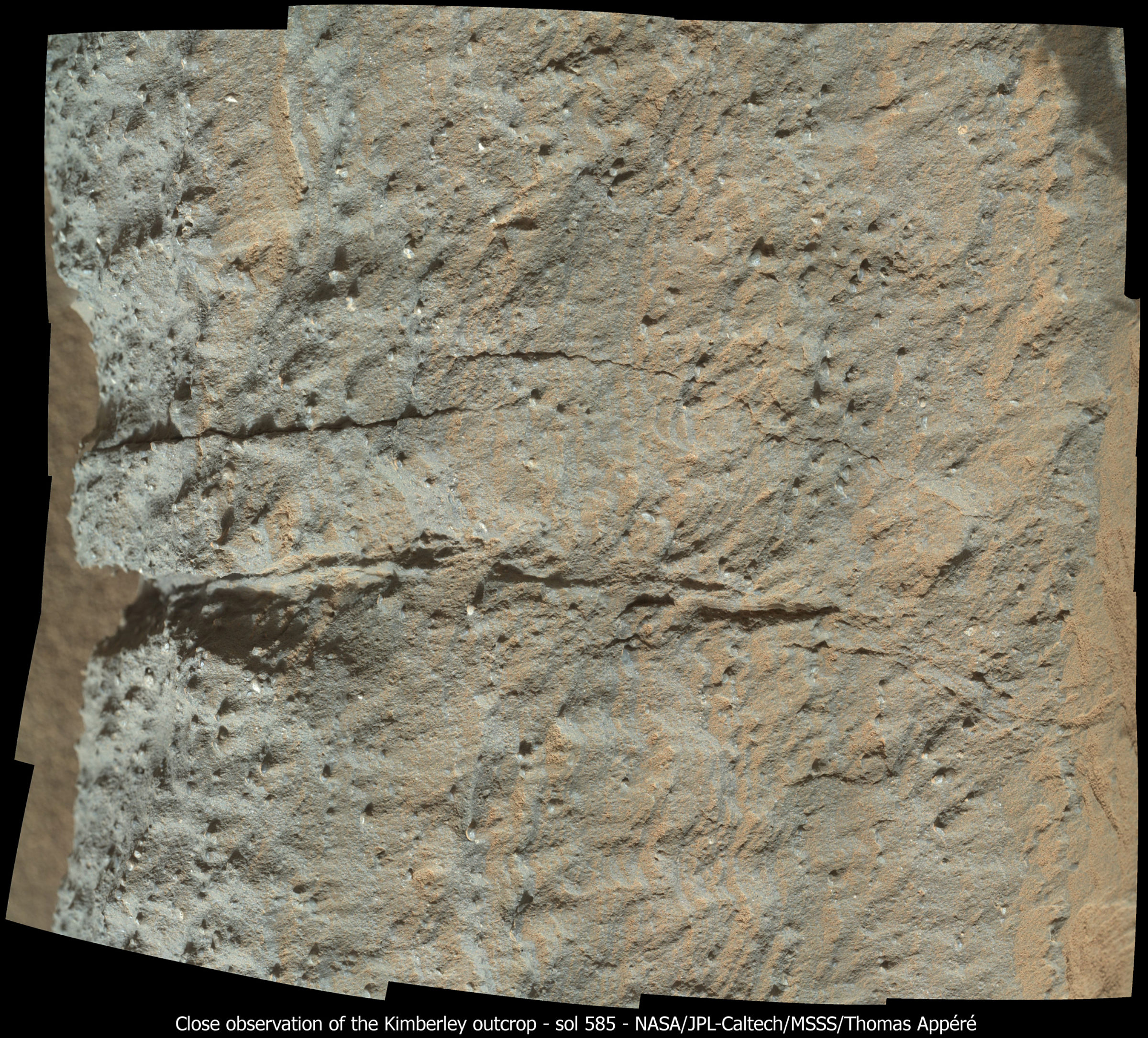
MSL planning will transition from restricted to nominal next week, so the weekend plan includes only 2 sols, 585 and 586. The first sol is dominated by contact science, mostly MAHLI imaging of areas of the outcrop that have not yet been observed by MAHLI. Targeted remote science is planned on both sols, with APXS and CheMin activities overnight. As SOWG Chair today, I was very busy working to squeeze all of these good observations into the plan. We couldn't fit everything we wanted, but very close! On Sol 586, the rover will bump back from the outcrop in preparation for another full set of MAHLI wheel images. MAHLI has been very busy the past few days, and not done yet!

Sol 587 Update From Ken Herkenhoff: The Kimberley (31 March 2014)
All of the activities planned for the weekend went well, and lots of good data have been received, with more on the way. Planning is no longer restricted now that the local time in Gale Crater and Pacific time are more in synch. So drive progress toward The Kimberley is expected to be more rapid this week. I'm SOWG Chair again today, and planning is going relatively smoothly so far despite the fact that we added a ~20-meter drive after a full set of wheel images. It looked for a while like we would not be able to do any targeted remote sensing before the wheel imaging due to power constraints, but once again the engineering team did a great job and found a way to fit the desired Mastcam observations into the plan.
Sol 588 Update From Ken Herkenhoff: The Path Ahead (1 April 2014)
The rover drove about 22 meters on Sol 587, to a location with a better view of the path ahead. So a longer drive (about 45 m) is planned for Sol 588, around the rocky outcrop and then south. But first, a large stereo Mastcam mosaic of the outcrop will be acquired, plus smaller mosaics of targets Point Coulomb, Brooking Gorge, and Castlereagh Hill. After the usual post-drive imaging and DAN active measurement of subsurface hydrogen, ChemCam will zap the ground to the right of the rover and Mastcam will acquire a mosaic of the hill to the west of the expected rover location. This final mosaic will be pointed assuming the drive completes as planned.

There were a couple of bright blips in Navcam images on sols 588 and 589 that got the Interwebs kind of excited. I haven't yet been convinced that they're anything other than cosmic ray hits, but there's an active discussion on unmannedspaceflight.com about what they are. But I find the the scientific exploration story and the beautiful photos much more thrilling than a couple of likely camera artifacts, so let's get back to that:
Sol 589 Update From Ken Herkenhoff: Soil Observations (2 April 2014)
Another successful drive on Sol 588, so another drive is planned for Sol 589 after Mastcam and ChemCam observations of a soil target named Chirup. If the ~30-meter drive goes well, we should be in position to acquire lots of images of The Kimberley, the waypoint selected for thorough analysis using all of the instruments. Therefore, post-drive images are planned that will allow a big set of images to be accurately targeted.

Around the corner of Mount Joseph, they could finally see the part of the outcrop they had intended to explore all along. Since their arrival on sol 589, they've spent a week working their way down the outcrop from north to south, taking an enormous number of photos. Ken said:
Sol 590 Update From Ken Herkenhoff: Arrival at The Kimberley (4 April 2014)
MSL has arrived at The Kimberley waypoint! The Sol 590 plan was dominated by Mastcam stereo observations of the extensive outcrop in front of the rover. Overnight, SAM will perform a cleaning activity in preparation for new sample analysis. The Mastcam mosaics should be useful in evaluating potential drill locations.
Here is just a tiny piece of the enormous Mastcam-100 panorama covering the Kimberley. It's well worth exploring the individual frames in detail, one at a time. There is so much variety in the layered rocks -- some thick, some paper-thin, some coarse, some fine. Here and there are Easter eggs of fantastical rock formations carved by wind.

The full panorama, when downlinked, will have 31 columns and 6 rows -- very close to 200 footprints. And it's in stereo, too, with data taken through both left and right eyes. We haven't even begun to appreciate all the detail in this panorama. You can see how much more image data remains to be downlinked in this snapshot from midnightplanets.com. The teeny images only exist on Earth as thumbnails; only the bigger ones represent full-resolution downlinked data.

If you visit the raw images websites regularly, you may have noticed something peculiar about Curiosity's stereo color panoramas. The right-eye images are square, and the left-eye images are wide rectangles. Why do they do that?
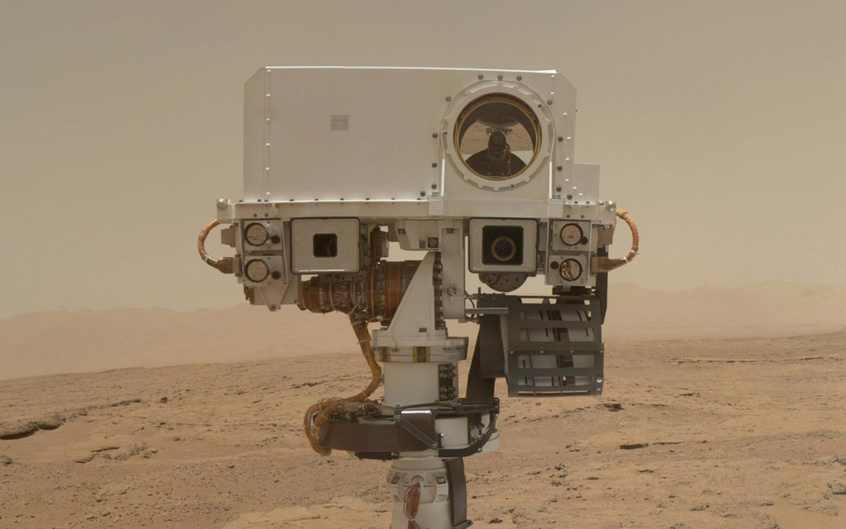
Here's a bit of detail for true rover geeks. First of all, remember that Curiosity's left and right eyes are not quite the same. The difference between the two color cameras is obvious when you look Curiosity in the face and see her different-sized eye apertures that make her look like: o.O

The smaller-aperture, right-eye camera, Mastcam-R or Mastcam-100, has a focal length of 100mm and a field of view of 5.1 degrees, while the larger-aperture, Mastcam-L or Mastcam-34 has a focal length of 34mm and a field of view of 15 degrees. But they have exactly the same detectors. That means the narrower-aperture Mastcam-R gets images with resolution three times higher than Mastcam-L, but it would take a 3-by-3 array of Mastcam-R images to cover a single Mastcam-L image. When they take stereo images (shooting photos through both sides simultaneously), it would waste a lot of bandwidth to return the entire Mastcam-L frame corresponding to each smaller Mastcam-R frame, so they crop the Mastcam-L frames closer to the coverage of the Mastcam-R. But it's hard to predict precisely where in the Mastcam-L frame you'll find the coverage of the Mastcam-R frame, because the two cameras aren't pointed straight ahead; they're toed in by 2.5 degrees. You can predict the vertical position of the Mastcam-R frame within the Mastcam-L frame, because that doesn't change, but you can't predict the horizontal position without knowing the range to the stuff being imaged and also accounting for parallax. So the Mastcam team can crop the top and bottom of the Mastcam-L images before returning them to Earth in order to save bandwidth, but they usually leave the left and right sides uncropped. If you dig in to the archived data and the daily sol reports on the mission, you'll find that this kind of stereo imaging has come to be known as a "shrink wrap stereo" observation. There, you now know a little bit of inside Curiosity mission lingo.
Anyway, getting back to Curiosity's activities: the sol 590 panorama was just the beginning of a week full of imaging. Here's Ken's summary:
Sol 591 - 593 Update From Ken Herkenhoff: Data Campaign (5 April 2014)
Planning for the weekend focused on investigating the troughs in front of the rover with ChemCam, Mastcam and MAHLI, then driving about 12 meters along the edge of the Kimberley outcrop and taking mid-drive measurements of subsurface hydrogen (water ice) content with DAN and imaging the outcrop with Mastcam. Lots of data are being acquired, so extra attention is being paid to prioritizing various observations so that they are received in the order they are needed. It may be a while before all of the data acquired during this waypoint campaign are received on Earth.
I was amused that, having seen a little hole in the ground within a furrow between the rover's wheels on sol 589, they couldn't resist placing MAHLI on it in order to peek down the hole on sol 590 before driving onward. On sol 592, they acquired a complete Mastcam-L 360-degree panorama of the Kimberley. As I write this, none of the full-resolution data for that one is on Earth yet.
On sol 593, they took a drive down the eastern edge of the Kimberley, and did something I haven't seen them do before: stop several times during the drive to take both Navcam and Mastcam panoramas of the outcrop. They've made one stop to do mid-drive imaging before, but the sol 593 drive had four different stops, four sets of Navcam and Mastcam mid-drive panoramas, a thorough survey of the Striated Unit at the eastern edge of the Kimberley. I checked with deputy project scientist Ashwin Vasavada to see if this was new for Curiosity, and he said:
The mid-drive stereo imaging of the striated unit on two drives last week (multiple stops each) was quite complex to plan and rarely done so far on the mission. This kind of imaging was directly related to distinguishing between the various hypothesis for the formation of the striated unit. It consists of many dipping beds with variations in grain size and resistance to erosion. The three-dimensional mapping from various angles will hopefully reveal subtle patterns that might distinguish between different kinds of fluvial environments that laid down those beds.
At the end of the sol 593 drive, Curiosity captured this particularly scenic view of the flat rocks of the Striated Unit, the two northern buttes of the Kimberley, and the distant rim of Gale.

From the same spot, looking southwest, she took more Navcam and Mastcam images of a rock that looks a lot like the Millennium Falcon! Ken Herkenhoff picks up the story from here:
Sol 594 Update From Ken Herkenhoff: Staying Put (7 April 2014)
The rover will stay put on Sol 594 and acquire lots of ChemCam and Mastcam data on interesting nearby rocks. I'm not scheduled in a tactical operations role today, but I'm following along because I'll be MAHLI/MARDI uplink lead tomorrow.
Sol 595 Update From Ken Herkenhoff: In Opposition (8 April 2014)
Mars is at opposition today, so Mars will rise at sunset and be visible all night here on Earth. On Mars, Earth is not visible because it is too close to the Sun. The MSL Sol 595 plan is dominated by a drive along the edge of The Kimberley outcrop with Mastcam and Navcam stereo imaging at 4 locations along the way. Lots more Mastcam images will be taken after the drive, to help plan our exploration of The Kimberley. It was an easy day for me as MAHLI/MARDI uplink lead, as only standard MAHLI wheel images, a stowed image, and a MARDI twilight image were planned.
Sol 596 Update From Ken Herkenhoff: Approaching an Outcrop (10 April 2014)
The surface near the rover isn't very interesting, so planning for Sol 596 focused on driving toward the outcrops up to 50 meters away. During the drive, the rover will stop and acquire DAN, Hazcam and MARDI data on the striated unit before moving on. So it was an only slightly busier day for me as MAHLI/MARDI uplink lead. After the drive, Navcam and Mastcam images will be taken to allow an approach to the outcrop on Sol 597.
If you check out the raw images for sol 595 you'll see they did another drive-by survey like the one on sol 593. There were four mid-drive stops to gather Navcam and Mastcam panoramas. Again, none of that data is on the ground yet at higher than thumbnail resolution; they are building up an enormous data set that is going to take weeks and weeks to receive on Earth. As a good flagship mission does.
At the end of the drive on sol 595, they backed away in order to get a good view onto the outcrop, especially Mount Remarkable, the southernmost of the Kimberley's three buttes. They took a Mastcam-100 panorama from this position, and quickly downlinked it. It is glorious. You must click through twice to enlarge this one to its full 20,000-pixel-wide glory, all 15 MB of it:

Why did this panorama come down to Earth before all the other ones? It came first because they told the rover to send it first, assigning it a higher priority -- a sure sign it's not just science data, it's also needed for tactical operations planning. Ashwin Vasavada confirmed this:
We're currently approaching the base of Mt. Remarkable, the southernmost of the three Kimberley buttes. We'll do some contact science on the middle unit and see how it compares physically and chemically to the striated unit. It is a potential drill location.
Drill, baby, drill!
I'm going to be on vacation for the next week. Hopefully, by the time I've come back, they'll have picked a spot to drill....
The Time is Now.
As a Planetary Defender, you’re part of our mission to decrease the risk of Earth being hit by an asteroid or comet.
Donate Today

 Explore Worlds
 Find Life
 Defend Earth

