
 Explore Worlds
 Find Life
 Defend Earth


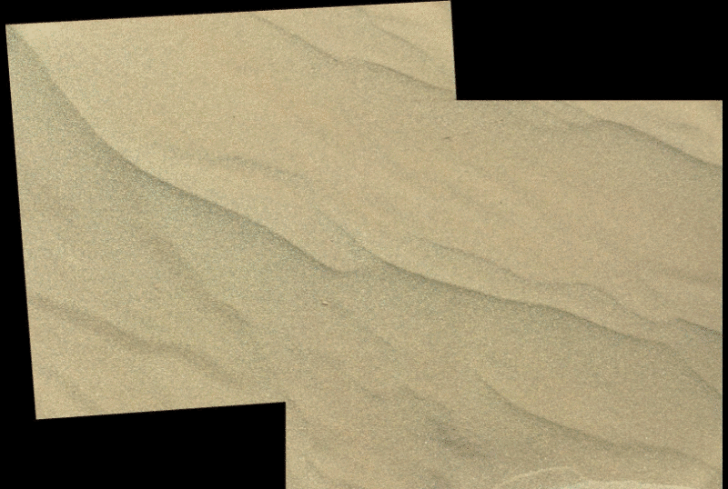
Curiosity update, sols 1218-1249: Digging in the sand at Bagnold Dunes
Written by
Emily Lakdawalla
February 10, 2016
Curiosity has spent the last month sampling and processing dark sand scooped from the side an active Martian sand dune. The activity saw some mission firsts. Sol 1228 was the first time that the rover took advantage of a special screen inside the CHIMRA sample mechanism to sieve sand into multiple size fractions; the rover delivered a sample of the intermediate-sized fraction to SAM on sol 1230. But the very next sol, the rover experienced an anomaly with CHIMRA that has not yet been resolved. The anomaly forced them to cut short the planned sampling activities, and they left the sample site on sol 1244. Two sols before they left, the MAHLI team, working closely with the rover drivers, captured the closest-ever images of a science target on the surface of Mars, capturing a photo with a scale of 15.6 micrometers per pixel of the fine grains sieved from the Namib dune sand.
As with most previous sample sites, Curiosity took a self-portrait at the sample site. It was taken on sol 1228, after the first scoop and sieving activity:

This is the sixth such self-portrait for Curiosity. (There was one more, at Buckskin, shot from a different angle.) Thomas Appéré put together this comparison of the six, which allows a study of how the distribution of dust on the surface of the rover has changed over time. The relative cleanliness of the rover's power supply through all of these dusty sols is striking!

Initially, the sampling effort proceeded rapidly. Curiosity drove up to the site on sol 1221, and took the first scoop on sol 1224, immediately delivering a sample of the fine fraction to both CheMin and SAM for analysis. They dumped the fine and coarse fractions of the sand in separate locations on sol 1226, generating dump piles A and B. The differences between the two are obvious even from a distance:
Here's what they looked like to MAHLI, up close. It is hard for me to wrap my head around the fact that each of the two square images below shows an area only a centimeter across. Only the material in the left image -- the fine fraction -- was delivered to CheMin, because its X-ray diffraction only works on particles smaller than 150 micrometers across. That material was also delivered to SAM. How the coarse fraction differs mineralogically from the fine fraction is, unfortunately, a question that CheMin can't answer, so Curiosity will have to use its other instruments (SAM, ChemCam, and APXS) to figure that out.

On sol 1228, Curiosity performed a new activity, employing the 1-millimeter sieve for the first time. In this procedure, the scooped material is passed through the 1-millimeter sieve, generating a coarse fraction; the fine fraction is then passed through the 150-micron sieve straight onto the ground. Curiosity generated one portion from the intermediate-size fraction for delivery into SAM on the same sol. Material that doesn't pass through the 150 micrometer sieve can't be delivered to CheMin, but anything that doesn't pass the 1-millimeter sieve is okay for delivery to SAM. Here you can see that sample sitting inside the scoop. You can also see the two stacked sieves at the top of the image.
After delivering the sample to SAM, Curiosity dumped the intermediate and coarse fractions onto the ground to make what the team calls piles C and D. I have stared for quite a while at the images that Curiosity later took of these dump piles on sol 1242, and I don't think there is a single grain of sand in view that is larger than 1 millimeter across; the largest is about 700 microns across, and most are 200 to 300 microns across, so I'm not convinced that there was actually anything in the scoop that didn't pass through the 1 millimeter sieve. So their "pile D" may actually be what they thought was "pile C", and there may actually be no coarse fraction of sand. But the operation did what it was designed to do -- generate a sample of scooped sand coarser than 150 microns and finer than 1 millimeter that was safe to deliver to SAM.

On sol 1231, they took a third scoop and prepared to repeat the multiple sieving effort to prepare a second aliquot of intermediate-size sand for delivery to SAM, because SAM achieves better detail on its analyses when it receives a double or triple portion of sample. With ordinary drilling operations, it's easy for CHIMRA to just spit two or three portions into the SAM sample inlet, but with the scooping operation that creates the intermediate-size sand sample, they only make one portion per scoop, so they have to go through the complete scooping operation two or three times to generate two or three portions. Unfortunately, CHIMRA suffered an anomaly on sol 1231 that brought sampling activities to a halt. An update from the Curiosity website explains the nature of the problem:
During processing of the third sample, an actuator in the sample-processing device did not perform as expected when commanded. This week, the Curiosity team is identifying possible reasons for the actuator's performance.
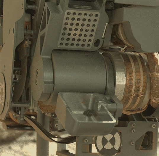
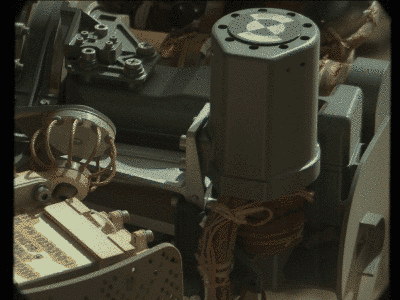
The processing device on the arm is named CHIMRA, for Collection and Handling for In-situ Martian Rock Analysis. The component that was commanded to open, but did not, is called the CHIMRA tunnel. It is opened by using the thwack actuator, a motorized component that also can deliver a firm tap to help clean sample material from a nearby sieve. Part of the third scooped sample is inside the CHIMRA tunnel after passing through a sieve. If the tunnel had opened via the thwack actuator as planned, the next step would have been to take an image of the sand inside it.
Here is a photo from sol 1226 showing how the CHIMRA tunnel usually opens. The tests that they did after the anomaly don't show it opening all the way; it is only opening to a very small gap. Here's an animation of one of the tests, performed on sol 1242.
From sols 1232 to 1240, while they were troubleshooting the CHIMRA anomaly, they could not use the arm for science, so they performed lots of remote sensing activities. Some of these activities were on the dump piles. Here is a montage showing all the work they did on pile A, the fine fraction that produced the samples for both CheMin and SAM.

They also pointed the Mastcam and ChemCam Remote Micro-Imager at the distant layered rocks at the base of Mount Sharp, their eventual target.

Finally, on sol 1241, they were permitted the use of the arm again. And they finally got the chance to do something that MAHLI lead scientist Ken Edgett has been hoping and planning to do for a long time: get MAHLI closer to Mars than ever before, the absolute closest that it's possible for MAHLI to achieve.
The MAHLI camera is protected from accidental impact on a rock target by two probes that stick out from the front of the instrument by 19 millimeters beyond the camera's front window. If those probes ever touch a rock, they trigger an immediate halt to arm operations. But the probes aren't sensitive enough to know when they're contacting loose sand; when working very close to sand, the arm engineers are working without the fault protection afforded by the probes. Making a mistake could mean accidentally shoving the MAHLI camera into sand.

The MAHLI camera itself is capable of focusing on targets at a minimum distance of 21 millimeters from the front of the window. But remember that MAHLI is stuck to one side of an enormous drill turret that weighs 34 kilograms, on the end of an arm that itself weighs 67 kilograms. It's astonishing to even think about positioning such a bulky thing with millimeter accuracy. But they do it, and routinely get MAHLI's front window to within 26 millimeters of a target.
Because they were at Namib for so long, it was possible to push that limit a little farther, shaving off one more millimeter, to a standoff distance of 25 millimeters. (They had been aiming for a standoff distance of 24 millimeters, or a half-centimeter beyond the probe tips. But because of the great size of the arm it's not at all unexpected to be off by as many as 3 millimeters, which is why a target standoff distance of 24 millimeters is the absolute limit of what they can aim for.) The picture below is the result of that effort -- the closest image that MAHLI has ever achieved of a natural target on Mars. Pushing the standoff distance a little closer to the target buys a little more resolution; in this case, the pixels are 15.6 micrometers across. Every little bit of resolution helps when you are trying to understand the geologic history of soil grains that are all smaller than 150 micrometers in diameter.

Ken told me that achieving this image was only possible because of trust developed between the MAHLI staff and the rover drivers over years of work together, going back to the mission simulations conducted four years ago, before the rover had landed. MAHLI is run from Malin Space Science Systems in San Diego and has a science team spread all over the country. The two teams (MAHLI and rover drivers) get together once a year, to discuss how to make improvements to operations to make MAHLI science better. It just happened that their most recent meeting was in January at JPL. At that meeting, they discussed the half-centimeter standoff distance at length, determined that they trusted each other enough to proceed, and they succeeded.
Looking at the images of the sand at Namib, Ken is rueful, because, he told me, the dune sands have turned out much finer than he had predicted in his Master's thesis work, 25 years ago. "My master's thesis has been tested and found wrong by my own instrument," he laughed. Science!
Curiosity began the drive away from the sample site on sol 1243, and achieved a very long, 75-meter drive today, sol 1249. They plan to wrap up the last of the sampling activities this weekend, dumping the rest of the third scoop. Since they have already cooked the intermediate-size fraction derived from the second scoop in SAM, there's no reason to try to add another portion now, so they'll just dump what they have left and move on while continuing to try to diagnose the problem with CHIMRA before their next sampling activity.
The Lunar and Planetary Science Conference abstracts were just released, and they have planned an entire session devoted to activities at the Bagnold dune field (PDF). I don't know if they will be able to get to any results from Namib before the conference, but I'll be attending that session. The map below came from Nathan Bridges' overview abstract; the blue line shows their future planned path around the dunes. Since landing, the dune field has represented a barrier that kept Curiosity away from Mount Sharp. In the last year Curiosity has explored sedimentary rocks from the base of Mount Sharp that extend underneath the dunes, but the goal has always been to cross the dune field to reach layered rocks that orbital data say contain clay and sulfate minerals. Once Curiosity has followed the blue path, the rover will finally have reached those interesting rocks and will be prepared to discover what they can tell us about Mars' wet history.

Here, as usual, are all the relevant updates from the USGS blogs.
Sols 1218-1220 update by Lauren Edgar: Change in plans (8 January 2016)
We came in this morning curious to see how the Sol 1217 bump and scuff went, but unfortunately there was an anomaly that prevented any use of motors during the plan. No motors meant no drive and no scuff, and most of our planned activities did not occur. So today turned into a recovery day – first trying to assess what happened and why it happened, and then figuring out how to proceed. Thanks to some impressive work by the science and engineering teams, we developed a plan that allows for recovery on Sol 1218, followed by some opportunistic science on Sols 1219-1220. I was the GSTL today, and we had a fun but challenging day trying to figure out how to do good science without moving the rover or the mast. Ultimately we delivered some ChemCam and Mastcam activities that will help to assess the composition of the soil, and search for any wind-driven movement of fines. The weekend plan provided a unique opportunity to do several coordinated change-detection observations using both Mastcam and REMS, at multiple times throughout the day. Looking ahead to next week, we’re hoping to proceed with the bump and scuff to get back on track with the Namib Dune sampling activities!
Sols 1221-1222 update by Ken Herkenhoff: Back on track (11 January 2016)
MSL has recovered from the motor controller anomaly, so tactical operations are back on track, with a drive to the dune sampling area planned for Sol 1221. I helped the ChemCam team select targets for LIBS and RMI observations today. Before the drive, ChemCam will observe a target named "Probeer" on a patch of bedrock in front of the rover. Mastcam will also image Probeer and acquire a stereo mosaic of the nearby part of the Namib dune. After the drive, in addition to the imaging planned to support arm work and targeted remote sensing, Navcam will acquire a small mosaic of the upper part of Mt. Sharp. Overnight, SAM will measure the abundance of methane in the atmosphere, then Navcam and Mastcam will look for clouds and dust early in the morning of Sol 1222. Later that sol, Mastcam and RMI will image the wall of a ~4 km-diameter crater about 30 km to the west. ChemCam and Mastcam will then observe the sky, and Mastcam will acquire a small stereo mosaic to look for changes in the nearby dune. Throughout the plan, REMS will measure wind speeds for comparison with any motion of sand observed by the cameras.
Sols 1223-1224 update by Ken Herkenhoff: Scooping sand for SAM (13 January 2016)
The Sol 1221 drive went well, including a wheel scuff in the dark sand dune, and the rover is in a good position for contact science. The Sol 1223-1224 plan is therefore loaded with arm activities, limited by the available power. First, MAHLI will take pictures of a couple of locations on the dune surface that has not been disturbed by the wheels, and of sand that was disturbed by the wheel scuff. Then the APXS will be placed as close as possible to the scuffed sand for an overnight integration. On Sol 1224, the scoop will be used to acquire a sample of the undisturbed dune sand. This sample will be sieved and the finest material (less than 0.15 mm diameter grains) will be dropped into the SAM inlet. SAM will then analyze the sample overnight, into the wee hours of Sol 1225. I'm paying close attention to planning today because I'm scheduled to serve as SOWG Chair on Friday.
Sols 1225-1227 update by Lauren Edgar: Analyzing dump piles (15 January 2016)
As seen in the images above, the arm activities on Sols 1223-1224 went well, and we’re ready for even more contact science in the 3-sol weekend plan. To kick things off, ChemCam will analyze the composition of the wall of the scuff and will also document a sharp-crested ripple with the RMI. Then Mastcam will document the ChemCam target and look for sand movement. Overnight, APXS will be used to measure the composition of the background undisturbed sand. On the second sol, a fine-grained portion of sand (150 microns) portions, and analyze the fine-grained dump pile with MAHLI and APXS. The third sol includes a Mastcam change-detection activity, followed by Navcam to monitor the deck to search for the movement of fines. Overnight, CheMin will analyze the sample that was delivered the previous sol. Phew! Sounds like a busy weekend for Curiosity!
Sol 1228-1229 update by Ryan Anderson: Selfie and Scooping (18 January 2016)
Our campaign to analyze the Bagnold dunes continues! In the Sol 1228 plan we have a bunch of arm activity, starting with a rover “selfie” in front of the sand dune, followed by scooping up and sieving a sample of sand. Mastcam and MAHLI will both thoroughly document the scooping process. Mastcam also has a change detection observation of the target “Hebron”.
On Sol 1229, Mastcam will repeat that change detection observation two more times. Mastcam also has observations of the dump piles from the scoop target “Gobabeb”, plus a Mastcam and Navcam photometry experiment. ChemCam will take passive spectra of the Gobabeb dump piles, followed by active analysis of dump pile A. That will be followed by atmospheric observations by Mastcam and Navcam.
In the afternoon on Sol 1229, ChemCam will analyze dump pile B, and Mastcam will take another change detection image of Hebron. The Mastcam and Navcam photometry experiment will also collect a few more images on sol 1229.
Sol 1230-1231 update by Ryan Anderson: Getting the scoop at Namib Dune (20 January 2016)
Our campaign to analyze “Namib Dune” continues! In the sol 1230-1231 plan the main event is dropping off some sand in the SAM instrument, but some of the other instruments got a workout too. The sol 1230 plan originally included a science block with some ChemCam, Mastcam, and Navcam observations, but unfortunately that had to be cut to save power, so those observations will have to happen over the weekend. With the science block removed, the first activity on sol 1230 is a Mastcam observation of the SAM inlet. After this, the rover will drop off a sample of sand for SAM to analyze. Then while the arm is active MAHLI will observe the dump piles, including some night-time observations using the built-in LEDs to illuminate the piles. APXS also has a couple of overnight measurements on two of the dump piles.
On Sol 1231, we will start off with some Navcam and Hazcam images to document where APXS was making its measurements, plus Mastcam observations of the SAM inlet again. This will be followed by some arm activities to clean out the components of the sample handling system. Then we'll dive back in and collect another scoop of material from the dune, sieve it, and deliver it to SAM too. Finally, APXS will be placed on another of our dump piles for an overnight measurement. And of course REMS and DAN will be collecting data each sol of the plan as usual.
Sol 1232-1235 update by Ryan Anderson: Working through the To-Do list (22 January 2016)
We are steadily continuing to check things off of the long “To Do” list for our stop at Namib Dune. This weekend’s plan starts on sol 1232 with a day dedicated to analyzing the sand samples with SAM. Then, on Sol 1233 we will start off with Mastcam change detection on the target “Hebron” and then a “multispectral” observation of the target “Hakos” using all of Mastcam’s different color filters. Next up, ChemCam has an RMI mosaic of “Gobabeb” dump pile A and then an analysis of the vein target “Sanitatis”. Next MAHLI will take a bunch of pictures of the various dump piles and scoops in the dune.
On sol 1234, we have a long, busy science block full of Mastcam and ChemCam. It starts off with Mastcam multispectral observations of the Sanitatis vein, and of dump piles C,D,E, and F. This is followed by some Mastcam atmospheric observations of the sun and the crater rim to help determine the amount of dust in the atmosphere. ChemCam will then analyze dump piles C and D, first with the laser off to get the reflectance spectra, and then with the laser on to get chemical composition. ChemCam will also use the laser to analyze the soil target “Dwyka” and then will finish up with a long distance RMI mosaic of Mt. Sharp. Then we will take Mastcam images of each of the ChemCam targets. We will finish up the science block with some photometry images from Mastcam and Navcam to help understand how light scatters off the Martian surface, and then some Navcam atmospheric monitoring movies. Finally, APXS will analyze dump pile B overnight.
The weekend plan also includes an early morning science block on the morning of sol 1235, which will contain more Navcam movies, Mastcam observations of atmospheric dust, and a repeat of the photometry experiment at a different time of day to capture a different lighting angle.
Sols 1235-1236 update by Ken Herkenhoff: CHIMRA Anomaly (25 January 2016)
I'm scheduled as MAHLI/MARDI uplink lead today, and was looking forward to planning more close-up imaging as the Namib dune campaign continues. Unfortunately, the CHIMRA behaved in an unexpected way during processing of the third scoop on Sol 1231, which prevented completion of the arm activities planned for last weekend. While experts evaluate the anomalous behavior and develop a recovery plan, no new arm activities will be planned. So I didn't have much to do today and focused on what should be done after the anomaly is resolved.
The Sol 1235 plan includes ChemCam and Mastcam change-detection images of Hebron and new observations of the scuff floor target Husab. In addition, ChemCam will analyze bedrock target "Etjo" and Mastcam will image CHIMRA to confirm its configuration. Overnight, SAM will
analyze the 0.15-1.0 mm size fraction of the dune sand. Before dawn on Sol 1236, ChemCam will search for evidence of water frost on both fine sand and the Etjo bedrock target. After sunrise, the ChemCam RMI and Right Mastcam will take pictures of the same frost targets, then Mastcam and Navcam will acquire an early-morning set of photometry images. Later that sol, ChemCam will observe the sky and Mastcam will repeat the Hebron observation to look for changes. Finally, Mastcam and Navcam will repeat the photometry observation later in the morning of Sol 1237.Sols 1237-1238 update by Ken Herkenhoff: CHIMRA Diagnostics (27 January 2016)
The cause of the CHIMRA anomaly is still being investigated, so no arm motion was planned today while diagnostic testing continues. Because only remote science observations are allowed, it was a straightforward day for me as SOWG Chair and for the rest of the tactical science team. The only challenge was that the volume of data expected to be received in time for planning on Friday is less than usual because MRO is performing some planned maintenance this week and cannot relay data from MSL. Fortunately, it looks like we will be able to get all the critical data via the Mars Odyssey orbiter.
In addition to the CHIMRA diagnostic tests on Sol 1237, ChemCam and Mastcam will image the alluvial fan northeast of the rover, at the base of the Gale crater wall. Mastcam and Navcam will also take stereo images of the edge of the area disturbed by the wheel scuff, named "Mniszechis Vlei." I don't know how to pronounce that name, and didn't even try!
The command to allow SAM to analyze the sample of dune sand was not received, so we'll try again overnight between Sols 1237 and 1238. Then during the day on Sol 1238 ChemCam will observe the sky and continue checking out new software that will allow autonomous ChemCam targeting. Mastcam change detection observations of the sand dune are also sprinkled throughout the plan. Finally, just after sunset the RMI will take images of the sky for instrument calibration. We have been trying to plan this observation for weeks, and were glad to be able to include it in today's plan.Sol 1239-1240 update by Ryan Anderson: Analyzing the Sands of Mars (29 January 2016)
Since the anomaly with CHIMRA is still being investigated, there was no science involving the arm in today’s plan. Still, there was plenty to do, and we had to be careful not to collect too much extra data because there is a backlog of data on the rover waiting to be downlinked to Earth.
On Sol 1239 we planned a bunch of observations of a target called “Gosser Schroffenstein” in the area called “Mniszechis Vlei” (I am really enjoying the names list lately) where the rover’s wheel scuff in the sand exposed a tiny scarp or cliff in the sand. This little scarp gives us a good view of the fine-scaled layering in the top few centimeters of the dune. ChemCam will take an RMI mosaic of Gosser Schroffenstein, followed by an active LIBS analysis targeting the face of the scarp. After that, the RMI mosaic will be repeated to see if the laser pulses caused any changes in the delicate sand scarp. Once ChemCam is done, Mastcam will take a 5 image stereo mosaic of the whole Mniszechis Vlei area. Mastcam also has another change detection observation of the target “Hebron” and Navcam has an atmospheric observation. Once the science is done on Sol 1239, we will do some more diagnostics on the CHIMRA. Later in the day on Sol 1239, CheMin will analyze some of the sand that was collected previously.
On Sol 1240 ChemCam has a few passive (no laser) observations of the Mastcam and ChemCam calibration targets. These are followed by a couple of long-distance RMI mosaics of Mt. Sharp. These are observations that I have been advocating for recently, so it was nice to be able to fit them in the plan today while I was on duty as the ChemCam science PUL. Mastcam will take color images to help document the long distance RMI mosaics, and will repeat the change detection observations of Hebron a couple more times.
Sol 1241 update by Lauren Edgar: Wrapping up at Namib Dune (1 February 2016)
Curiosity is still parked at Namib dune, and we are we are close to finishing the science investigation here. The team is still working to diagnose the CHIMRA anomaly, but the arm was cleared for use in today’s plan.
The science activities in today’s plan include some additional MAHLI images to supplement the previously acquired selfie, and some long-distance ChemCam RMI mosaics to study layering on Mt. Sharp and the northern crater rim. We’ll also acquire a Mastcam image to document the target “Erongo,” and use Navcam to search for dust devils and monitor the atmosphere. Then we’ll use MAHLI to document several of the scoop and dump locations. There’s also an early science block on the morning of Sol 1242, during which Mastcam and Navcam will image the ripple target “Epupa” under favorable morning illumination conditions. I’ll be on duty later this week so I’m catching up on our remaining science requirements at this location.
Sol 1242 update by Lauren Edgar: Last analyses of the dump piles (2 February 2016)
Today was the last day for science activities at Namib Dune, as we’re planning to drive away on Sol 1243. It’s fun looking at the disturbed sand in the workspace, and realizing how much we’ve done here (is it just me, or does it look like a big sandbox full of scoops, dumps and wheel scuffs?). While it might look like Curiosity has just been playing in the sand, we’ve managed to accomplish a lot of really great science here.
Today’s plan includes additional CHIMRA diagnostics, and a number of MAHLI and APXS observations of the dump piles. It’s impressive how close we’re able to get MAHLI to the sand, which should enable some really high-resolution studies of the grain properties. The plan also includes several Mastcam and ChemCam RMI observations of the ripples to look for changes. I’ll be on duty tomorrow, so I’m looking forward to driving off in search of the next drill target!
Sol 1243 update by Lauren Edgar: Getting ready to leave Namib Dune (3 February 2016)
The contact science activities on Sol 1242 were successful, which completed our investigation at the Namib Dune sampling location. I love the above Navcam image, which shows just how close we were able to get MAHLI to the dump piles, followed by the really high-resolution MAHLI image! Now it’s time to leave Namib Dune and head off in search of the next drill location.
I was the GSTL today, and it was a pretty straightforward day. Due to additional CHIMRA diagnostics, there wasn’t much time for additional science. The plan includes turning and backing up to allow a DAN active measurement over the dune sampling location. In the geology theme group, we focused our attention on post-drive imaging, to prepare for the possibility of contact science or drilling in an upcoming plan. In addition to all of the great science on active dunes, it’s exciting to think about the bedrock and where we might drill next!
Sol 1244 update by Lauren Edgar: Bump, Set… Scuff! (4 February 2016)
Today’s plan is focused on bumping towards a bedrock target to set us up for contact science in the weekend plan. As we bump forward, we’ll use the rear wheels to create one last scuff in Namib Dune, which we’ll image as we drive away.
I was the GSTL today, and we had a busy morning deciding where to drive to and how to image the scuff that we’ll create. We decided to bump just a few meters away to a target that will allow us to characterize typical Murray formation bedrock (the intended target is in the lower half of the above Navcam image). Before the drive, we planned a ChemCam passive observation of a distant crater to characterize the material that makes up the Gale crater walls. We also planned a Mastcam image of a freshly broken rock named “Askevold,” and Mastcam deck monitoring to search for the movement of fines. Then we’ll drive forward slightly, turn the wheels to undermine a ripple, image it with Mastcam, and then drive towards the contact science target. After the drive we’ll acquire imaging to prepare for contact science and targeting in the weekend plan, and we’ll also do some ChemCam calibration activities. Looking forward to being back on bedrock!
Sols 1245-1247 update by Lauren Edgar: Analyzing Murray formation bedrock (5 February 2016)
On Sol 1244, Curiosity bumped 2 meters forward to get to a nice patch of bedrock. The focus of the weekend plan is to study typical Murray formation bedrock, do some targeted remote sensing, and then drive towards the Naukluft Plateau.
The 3-sol weekend plan starts by using the DRT to clear off the dust on the target “Kudis.” Then we’ll acquire MAHLI images of this typical Murray formation bedrock. Nearby, there’s an interesting patch of nodules, so the science team decided to go for a second MAHLI target named “Tinkas.” In addition to all of the contact science on “Kudis” and “Tinkas,” MAHLI will also be used for wheel imaging and to check out the REMS UV sensor. Overnight, we’ll acquire APXS data on both targets, to compare the typical bedrock composition to the nodule-rich composition. On the second sol, Curiosity will wake up early for some atmospheric monitoring observations. Around midday, we’ll acquire Mastcam multispectral imaging of “Kudis,” followed by a ChemCam passive observation of the sky. ChemCam will also be used to assess the composition of typical bedrock and the nodule-rich rock, and Mastcam will document the local geology. On the third sol, Curiosity will drive towards the Naukluft Plateau, and acquire post-drive imaging to prepare for next week. Sounds like a busy weekend!
Sol 1248 update by Ken Herkenhoff: Re-planning a Drive (8 February 2016)
It's not Groundhog Day, but the drive planned for Sol 1247 will be attempted again on Sol 1248. Due to a minor sequencing error, the arm activities that were planned for the morning of Sol 1247 were precluded. Because the arm was not stowed that sol, the drive did not execute and the rover has not moved. We were not able to recover the MAHLI imaging of the REMS UV sensor that was planned for Sol 1247 because it will be in shadow by the time the Sol 1248 activites start at about 11:00. So it was an easy day for me as MAHLI/MARDI uplink lead, with only a MARDI twilight image to plan. We were able to squeeze in some ChemCam and Mastcam observations of "Nil Desperandum" before the drive, in addition to the usual drive-related observations.
Sol 1249 update by Ken Herkenhoff: Twelve kilometers and counting (9 February 2016)
The rover has traversed over 12 km since landing, and another drive is planned for Sol 1249. The tactical planning team decided to forgo targeted remote science observations before the drive to allow more time for driving. The goal is to get the vehicle to a location that will allow the remaining dune sample to be dumped and examined in detail this weekend, and this will require more drive time than originally planned. With only a few science observations in the plan, it was an easy day for the team. I'm MAHLI/MARDI uplink lead again today, planning another MARDI twilight image.
Protect Our Shared Future
You help us defend humanity and prevent asteroid impacts. Donate now to become a Planetary Defender!
Donate