
 Explore Worlds
 Find Life
 Defend Earth


Curiosity update, sols 1166-1217: First reconnaissance of Bagnold dunes
Written by
Emily Lakdawalla
January 7, 2016
In the six weeks since my last detailed Curiosity update, the rover has driven to, on, and around a couple of active barchan sand dunes on Mars. Progress was slowed a bit by the holidays and a couple of ill-timed (though minor) rover faults and Deep Space Network problems, but they have now completed their reconnaissance of the dunes and are ready to start a really cool sand sampling campaign at Namib dune. The campaign will last a few weeks, and then they'll drive on, around the north edge of the dunes and toward Murray buttes. Here's a map of the traverse from Marias Pass to the dunes:

After wrapping up science in the Stimson unit near Big Sky and Greenhorn, Curiosity began the final drive south toward the dunes on sol 1151 (November 1). Scientists have been looking forward to examining these dunes up close since before the landing. They differ in several ways from the small sand ripples that Curiosity has seen through the rest of the mission. Seen from orbit, they are very dark, and not nearly as red as other ripples. CRISM data from Mars Reconnaissance Orbiter shows them to have a distinct signature of olivine, at least in some places, and the HiRISE camera has observed them to be active. So the first item of business, after Curiosity's arrival, was to take a close look to see if they differed visually or in composition from the ripples Curiosity has seen before. The second was to see if these dunes were any easier to drive on than other sand Curiosity has passed by.
It took about three weeks of driving, until sol 1174, for the rover to pull up to the margin of one of the barchans, which the team have named High Dune.

(You can view this panorama on roundme, too.)
Curiosity zapped the dune with ChemCam on sol 1177, drove atop its edge (while recording MARDI video) on sol 1181, and then took a close look with MAHLI to examine the grains and rover tracks on sol 1182, among other activities, conducted during and after the Thanksgiving holiday. Interspersed with all of this, they performed SAM and CheMin analyses of the Greenhorn sample, to prepare for having to dump it before they could sample the dune.
Here's what the ripple looked like when ChemCam was done with it. I'm just so happy to see these robust ChemCam rasters again.

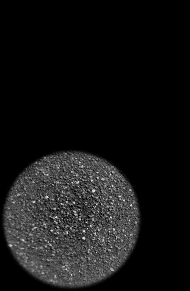
The sand in these dunes is quite different to anything I've ever seen from Mars before. It's so dust-free, and so beautifully sorted.

(I may have gotten just a bit excited about this sand on Twitter when I first beheld it, as did others. It is the most sand-like sand I've ever seen on Mars. I guess there's no question that I am a geology geek.)
One of the things that has puzzled me about Curiosity's views of the dunes is that when viewed from Mastcam, the dunes look light and reddish, similar to the rocks, but when viewed with Navcam, they look very dark, as they do from orbit. Thanks to some reading I've been doing on Mastcam I think I now understand why. It has to do with the different spectral sensitivities of the Mastcam and Navcam instruments. When it does ordinary RGB color imaging, Mastcam views Mars through an infrared cutoff filter, which means that wavelengths longer than about 690 nanometers are blocked from the sensor. Curiosity's Navcam looks at Mars through a broadband filter that covers red and near-infrared wavelengths, from 580 to 800 nanometers. The dune material has similar brightness to the rocks when viewed in the visible wavelengths sensed by Mastcam, but it is much darker than the rocks in the longer infrared wavelengths sensed by Navcam. Incidentally, Mars Reconnaissance Orbiter's HiRISE RED channel -- the one used for most of its imaging of the Martian surface -- views a similar part of the spectrum to Navcam, from 570 to 830 nanometers, so the contrast between dunes and rocks should look the same to HiRISE as it does to Navcam. Which it does!
The Curiosity team had hoped that the different substrate of the active dune field would provide better traction than the other sand ripples that Curiosity has encountered, but at least initially, the tests have indicated that they're no better for driving. But at least they're no worse. It doesn't mean that Curiosity can't drive on dune sands at all, just that the usual precautions need to be observed, things like trying to keep at least a couple of wheels on rock, and where that's not possible, making sure there's an escape route out of the sand that aims downhill.
Having performed their initial assessment of the dune, on sol 1185 they drove east to a second barchan, named Namib dune, arriving on sol 1192. Then they drove counterclockwise around Namib, to the south, to visit its lee side, arriving on sol 1196.

The rover sat there through the Christmas and New Year holidays, watching for sand motion and taking an epic self-portrait with Mastcam, the first ever. I've just uploaded it to roundme -- you can pan around it in the browser, but it's even more fun to look at with Google Cardboard.
Curiosity attempted to dump the Greenhorn sample on sol 1200, but suffered an arm fault; it wasn't major, and they were able to finish up the dump and post-dump inspection activities as normal on sol 1202. The views of the sand dunes around this time are just spectacular. I can't include them all here; just go to sol 1192 and scroll forward in time, taking in all the gorgeousness, either at midnightplanets.com or unmannedspaceflight.com.

Another activity they were working on through all this time is testing out a new autonomous target selection capability for ChemCam, using AEGIS. AEGIS (Autonomous Exploration for Gathering Increased Science) is a software package that was first used on Mars by the Opportunity rover to help it select targets for Pancam imaging in the middle of long drives with no interference from Earth. On Curiosity, it's being tested for use by ChemCam to help make sure that the laser hits very tiny features like veins; this poster presented by Tara Estlin and coauthors to the 2013 AGU meeting explains in a little more detail. They tested AEGIS on sols 1157, 1160, 1184, and 1199.
Curiosity departed the lee side of Namib dune on sol 1215, returning to the sol 1192 spot. The team is now searching for a good spot to sample the sand dune. There are a lot of constraints on the choice of sampling target. Scientifically, they want it to be one that looks like olivine from orbit, so that they can connect orbital measurements with ground data. Most of the other constraints have to do with engineering: for example, they want to face east in order to have good visibility to Earth in the morning with the high-gain antenna for the rover to receive its daily list of commands, but they would like it to face north in order to make sure that the area reachable by the arm isn't shadowed by the rover during any part of the day. And they don't want to drive too far onto sand, to avoid slipping wheels.
Once they've selected and settled in at their sample site on Namib dune, it'll be the first time they've used Curiosity's sand scoop since Rocknest, shortly after landing (sols 56-101). The first part of the sampling activity will look a lot like Rocknest, but then they're going to deploy a sample handling capability they've never used before. To date, they have sieved their sample using a single sieve, one that filters out material coarser than 150 micrometers in diameter. They dump the coarse fraction before portioning the fine fraction for CheMin and SAM. But there's actually another sieve available in CHIMRA, with 1-millimeter holes. After using the 150-micrometer sieve, they can dump the fine stuff and then send the coarse fraction through the 1-millimeter sieve. After shunting the coarse stuff into a reservoir, they'll be left with all the material between 150 micrometers and 1 millimeters in their sand scoop -- everything that is sand-sized. There's a little pocket inside the sand scoop that lets them portion out a small amount of this material for delivery to SAM. This stuff can't be dropped into CheMin (it's too coarse for X-ray diffraction), but they can put it into SAM. It'll look different than previous sample delivery operations, because it actually gets dumped from the scoop rather than delivered through the portioner. So that's something fun to watch for in a couple of weeks.
It's all very complicated, but in the end they'll be doing what any good Earth sedimentologist would do, sending a sediment sample through stacked sieves to study whether different grain size fractions have different properties. My next update will be after the sand-sampling operation has completed. In the meantime, here are nearly 6000 words from Ken Herkenhoff, Lauren Edgar, and Ryan Anderson covering the last 6 weeks of rover activities in more detail, courtesy of the USGS Astrogeology Science Center.
Sols 1167-1168 update by Lauren Edgar: Onward to the Bagnold Dunes (18 November 2015)
The Bagnold Dunes are tantalizingly close, and this week is mostly focused on driving to the dunes. On Sol 1167 Curiosity drove 39 m, and the dunes are starting to look pretty big, as seen in the above Navcam image. For more on our plans when we get to the dunes, check out this recent press release.
The plan today looks very similar to yesterday, with a pre-drive science block, a drive, and post-drive imaging. Science activities include Mastcam and ChemCam observations of the local bedrock at a target named “Etosha,” as well as Mastcam deck monitoring to look for fine sand that might accumulate as we approach the active dunes. After the drive we’ll acquire standard imaging to prepare for future targeting and terrain assessment. We’re also planning a SAM atmospheric observation to look for methane, exactly one Mars year after the previous high detections. Meanwhile, here on Earth, the ChemCam team is meeting at the USGS in Flagstaff, which means that Ken, Ryan and I will only be able to blog intermittently this week. But I’m looking forward to being back on GSTL duty next week… especially with the exciting dune campaign coming up!
Sols 1170-1172 update by Lauren Edgar: Studying bedrock, sand, and sky (20 November 2015)
This week Curiosity has been driving towards the Bagnold Dunes and characterizing the bedrock and sand along the way. After a successful SAM methane experiment and 36.5 m drive on Sol 1168, Curiosity spent Sol 1169 recharging and assessing some of the local bedrock and dunes.
The weekend 3-sol plan starts with a number of environmental monitoring activities to assess atmospheric opacity and composition. The second sol includes several ChemCam and Mastcam activities to study the local bedrock and prepare for the upcoming dune investigation. We’ll also use Navcam to search for dust devils and monitor clouds and wind, and to monitor the deck of the rover to look for dust and sand accumulation. On the third sol we’ll drive and take our standard post-drive imaging. The plan also includes SAM and CheMin activities for prepare for future sampling. I’ll be on duty next week, so I’ve been monitoring the weekend activities and getting ready for some exciting observations next week.
Sol 1173 update by Lauren Edgar: Dune monitoring (23 November 2015)
Over the weekend, Curiosity drove 51 m closer to the Bagnold Dunes. I’m on duty as the Geology Science Theme Lead, and today we’re planning Sol 1173, which includes a short science block, a drive, post-drive imaging, and some untargeted science in the afternoon. The main focus of today’s plan is to monitor the dunes and document the bedrock along the way. We’ll start with several Mastcam observations to monitor two of the dunes, as well as a small sandsheet directly in front of us. Then we’ll drive and acquire post-drive imaging to prepare for targeting tomorrow. In the afternoon, we’ll take several Navcam observations to monitor the atmosphere and search for dust devils. Then we’ll take some additional Mastcam mosaics to monitor the dunes and bedrock under different lighting conditions. This late afternoon lighting can be very useful to bring out subtle textures in the dunes and rocks, and will help us figure out the best time of day to image these features during the Bagnold Dune campaign.
Sols 1174-1176 update by Lauren Edgar: A feast of activities (24 November 2015)
As many Americans are making plans for Thanksgiving, we’re making sure that Curiosity has plenty to do over the holiday weekend. On Sol 1173, Curiosity drove 45 m to the south, which put us in a great position in front of a small sandsheet and the stoss side of a large dune.
Today we’re planning 3 sols to cover part of the long weekend (we’ll plan an additional 3 sols tomorrow). I was the Geology Science Theme Lead today, and it was a real challenge to fit everything into the plan while staying within our power constraints. On the first sol, Curiosity will acquire ChemCam and Mastcam on a small patch of sand to assess its composition and morphology. Then we’ll drive further to the southwest, and take some Navcam images to prepare for future targeting. We’ll also run the first of several change detection experiments, to try to monitor sand movement in a small sandsheet. The second sol includes a number of environmental monitoring activities to assess the composition and opacity of the atmosphere using ChemCam and Mastcam. On the morning of the third sol, we’ll use Navcam to monitor the atmosphere and search for dust devils. In the afternoon of Sol 1176, we’ll perform another part of the change detection experiment to look for ripple movement, and we’ll acquire another Mastcam mosaic of the dune to our west to look for variations in ripple morphology. We’ll also perform some ChemCam calibration activities, a Mastcam mosaic of the local bedrock, a clast survey, and a Navcam atmospheric observation. Throughout the plan, REMS will be taking a number of observations, which should be very helpful to assess wind speeds as we monitor these dunes. Adding further complexity to the plan, CheMin will dump the “Greenhorn” sample and analyze an empty cell in preparation for upcoming sampling. After such a busy plan over the holiday, Curiosity will require some time to rest and recharge (sound familiar?). Safe travels Curiosity!
Sols 1177-1179 update by Lauren Edgar: Recipe for a successful rover plan (25 November 2015)
The 28 m drive on Sol 1174 ran successfully and Curiosity is now parked in front of a beautiful sand sheet and sand dune!
Today science and engineering teams cooked up a full 3-sol plan, to account for the second half of the Thanksgiving holiday weekend. The team started with equal parts Mastcam and ChemCam to analyze the sand and bedrock, and to monitor the movement of sand across the rover deck and in nearby ripples. The meat of the plan consists of SAM preconditioning, drop off of the “Greenhorn” drill sample to SAM, and an EGA (evolved gas analysis). Essentially that means that we’ll heat the sample up in an oven and measure the major gases that are released. Since this is a very power intensive activity, we kept the sides to a minimum. On the third sol we planned a healthy dose of MAHLI wheel imaging to monitor wear and tear. We also added in a handful of post-drive imaging activities since the wheel imaging requires us to move slightly and we want to have updated information for targeting. And we squeezed in an additional Mastcam change detection experiment to monitor the ripples on the third sol. Sprinkled throughout the plan are our standard RAD and REMS and DAN measurements. Add in a dash of excitement about the opportunity to study active dunes on another planet, and it’s sure to be a great weekend on Mars.
Sol 1180 update by Ken Herkenhoff: Heater table update (30 November 2015)
The MAHLI wheel imaging planned for Sol 1179 completed nominally, and the initial assessment showed no broken grousers. The rover is now poised to begin testing mobility in the dark sand in front of the vehicle, but first a table used onboard to determine when heating is needed must be updated. No heating is allowed this sol after the update, which limits the activities that can be planned. So it was a relatively quiet day for the science planning team, with a Navcam search for clouds and ChemCam/Mastcam observations of a sandy ripple named "Khumib" and an outcrop dubbed "Abenab" early in the afternoon.
Sol 1181 update by Ken Herkenhoff: Mobility testing (1 December 2015)
Due to problems at the Goldstone DSN complex, the bundle of command sequences generated for Sol 1180 could not be sent to MSL. So the rover performed minimal activities on Sol 1180, as expected in “runout” mode. The good news is that the rover’s batteries are charged up, and the engineering team determined that activities can be planned after the heater table update by avoiding the types of heating that are affected by the update. So the Sol 1181 plan includes the first part of the mobility test: drive a few meters into the dark sand in front of the rover, then back up enough to allow study of the rover tracks using the arm instruments. During the drive, MARDI will acquire many images of the surface behind the left front wheel, to document the sand as it is disturbed by the wheel. After the drive and the standard post-drive imaging are completed, ChemCam will observe its calibration targets, RMI and Mastcam will image part of Mount Sharp in the distance, and Navcam will search for clouds.
Sol 1182 update by Ryan Anderson: Studying our Tracks (2 December 2015)
Today’s plan is focused on studying the results of yesterday’s mobility test where we drove a little ways into a sand patch and then backed out, leaving trenches where the wheels were. Yes, we’re disturbing some of the very photogenic sand ripples that we have been seeing, but it’s for a good cause: it teaches us more about how well we can drive in that sand, and by using the wheels to make trenches like this, we can get a better idea of the internal structure of the sand ripples.
In the Sol 1182 plan Mastcam has a 2x2 mosaic of a ripple cut by the trench called “Sechomib”, a multispectral observation of the left wall of the trench at a target called “Hoanib”, and a 6x3 mosaic of an outcrop called “Aminius”. ChemCam has two observations, one on Hoanib, and the other on the far wall of the trench, called “Awasib”. Mastcam will take documentation images of both of these targets after ChemCam has finished.
Once the remote sensing is done, the rest of the plan is focused on contact science on the sand, with MAHLI images of the undisturbed sand, the walls of the wheel track, and the interior of the track. Then APXS will make an overnight measurement of the track.
Sol 1183 update by Ken Herkenhoff: Completing mobility tests (3 December 2015)
Today we are planning the last sol of the mobility test, turning and backing out of the sand while taking multiple Hazcam images, then pausing to take Navcam and Mastcam images of the wheel tracks. But first, Mastcam will take multispectral images of a rock named “Narabeb” and a soil target dubbed “Kubib.” The right Mastcam will also acquire another 2x2 mosaic of Secomib, to look for changes in the trench wall, and image the spots where the APXS was placed on the sand. The biggest challenge for me as SOWG Chair today was to prioritize the post-drive data, as the volume of data expected to be received in time for planning tomorrow is smaller than usual. We’re hoping that the rover will drive close enough to “High Dune” to allow contact science on the dark dune sand, so we’ll need good images of the arm workspace. But we’re also planning to drive again this weekend, so we’ll also need images in the direction of the drive. It looks like we will get just enough data to enable a full weekend plan, assuming that all the orbiter and ground assets work as we’ve come to expect.
Later in the afternoon, the ChemCam RMI and right Mastcam will acquire a small mosaic of an outcrop up on Mount Sharp, and both Mastcams will image the ground in front of the rover. Finally, the left Mastcam will acquire a mosaic of the ground and sand to the right of the rover, and MARDI will take another twilight image.
Sols 1184-1187 update by Ryan Anderson: Busy weekend at High Dune (4 December 2015)
The rover has arrived at the edge of “High Dune” and we have a very busy weekend plan studying the dune and then continuing to drive. On sol 1184 we will continue testing the AEGIS software that allows the rover to fine-tune its targeting for ChemCam. After that, ChemCam will analyze two targets “Barby” and “Kibnas” and Mastcam will take a 7x8 mosaic of a sand ripple. In the afternoon, MAHLI will take some images of Barby and Kibnas, and then APXS will take measurements of both targets. At night, MAHLI will be back in action for some night-time images of Barby and then APXS will do a longer overnight measurement.
On sol 1185, after driving the rover will collect standard post-drive imaging, plus an 8x1 Mastcam mosaic. On sol 1186, the rover will take some Navcam images to make sure sand from the dunes isn’t piling up on the rover deck or damaging the camera lenses. Originally we were hoping to do some atmospheric measurements on sol 1186 as well, but they were removed from the plan because it was getting too complicated. We still have plenty of atmospheric science planned for the early morning science block on sol 1187 though, including two Navcam movies, a ChemCam passive sky measurement, and Mastcam measurements of atmospheric dust.
Sols 1187-1188 update by Lauren Edgar: Analyzing bedrock and sand (7 December 2015)
After successfully completing a mobility test last week (as seen by our wheel tracks through this sand patch), Curiosity drove ~35 m toward a dune that is now named “Namib.” We’ve accomplished a lot of reconnaissance imaging of the dunes, and we’re looking ahead to monitoring the dune slipface and sampling the chemistry and mineralogy of an active dune. We’ve also acquired some beautiful close-up images of the sand grains, as seen in the above MAHLI image that just came down.
Today’s 2-sol plan includes a targeted science block followed by a drive and post-drive imaging, and an untargeted science block on the second sol. Sol 1187 includes several ChemCam and Mastcam observations of the local bedrock at targets named “Rehoboth,” “Hamilton_Range,” and “Twyfelfontein.” We’re also testing out some software for autonomous target selection. Then we’ll drive towards the “Namib” dune and take post-drive imaging to prepare for future targeting. Overnight, Curiosity will perform a SAM Electrical Baseline Test to make sure that the power and data interfaces are all operating smoothly. On the second sol we’ll use ChemCam, Mastcam, and Navcam to monitor the composition and opacity of the atmosphere and search for dust devils.
Sols 1189-1190 update by Ken Herkenhoff: Drive precluded (9 December 2015)
Because of a problem with one of the DSN station antennas, the data needed to plan a drive today were not received, so the Sol 1189-90 plan is dominated by remote sensing observations. Neither driving nor arm activities are possible until the necessary images are retransmitted. On Sol 1189, ChemCam and Mastcam will observe the bedrock to the right of the rover, then Mastcam and Navcam will image the workspace in front of the rover to enable contact science to be planned on Friday. Early on Sol 1190 (when the lighting will be good), Mastcam will acquire a stereo mosaic of the "Namib" dune to the east. Later that sol, Navcam will search for clouds and ChemCam will perform a calibration activity.
Sols 1191-1193 update by Ken Herkenhoff: On the road again (11 December 2015)
We received the data needed to plan contact science and a drive, and the 3-sol weekend plan is another full one. I was busy as MAHLI/MARDI uplink lead, planning observations of a couple targets on an outcrop right in front of the rover. On Sol 1191, MAHLI will acquire full suites of images of "Elizabeth Ray" and "Pomona" before the APXS is placed on Pomona for an afternoon/evening integration. During the integration, ChemCam and Mastcam will observe bedrock targets "Messum" and "Karoo." After sunset, the APXS will be placed on Elizabeth Ray for an overnight integration. Early on Sol 1192, Mastcam will acquire another stereo mosaic of the Namib dune (taking advantage of morning light) and a single image of a ridge named "Paresis." Later that sol, the rover will drive toward the southwest and acquire the usual post-drive data. On Sol 1193, ChemCam will acquire calibration data and Navcam will search for clouds. Finally, early on Sol 1194 (before handing over to the next plan) Navcam and Mastcam will search for morning clouds and dust devils, and measure the amount of dust in the atmosphere by imaging the Sun.
Sols 1194-1195 update by Lauren Edgar: Driving around “Namib Dune” (14 December 2015)
Over the weekend Curiosity drove 42 m closer to “Namib Dune, and the view is pretty spectacular. We’ve received a lot of beautiful Mastcam and Navcam images, which can be found here.
In today’s 2-sol plan, we’ll continue driving around the “Namib Dune” to get to the lee side. It was a pretty straightforward day for me as GSTL, and Ken as the MAHLI/MARDI PUL. On the first sol Curiosity will acquire ChemCam and Mastcam observations of targets named “Karfenkliff” and “Grillental” to characterize some of the local bedrock and veins. We’ll also take a Mastcam stereo mosaic of “Namib Dune” to better understand the morphology of the ripples and grain flows. The plan also includes a Mastcam image of the rover deck to monitor the movement of particles. Then we’ll drive for ~47 m and take post-drive imaging to document the local geology and prepare for targeting in Wednesday’s plan. On the second sol we’ll perform a number of ChemCam calibration activities and take a Mastcam tau to monitor atmospheric opacity.
Sols 1196-1197 update by Lauren Edgar: Aeolian paradise (16 December 2015)
On Sol 1194 Curiosity drove 47 m around the lee side of “Namib Dune.” The latest Navcam images reveal many beautiful aeolian features on the slipface and interdune deposits.
In today’s 2-sol plan, we’ll continue driving around “Namib Dune.” On the first sol we’ll use ChemCam to assess the composition and grain size of a ripple. Then we’ll use Mastcam to image the brink of the dune and its slipface to characterize the dune morphology. We’ll also use Mastcam to document an outcrop with an unusual purple hue. Afterwards, Curiosity will drive even closer to the dune slipface, and we’ll take post-drive imaging to prepare for targeting over the weekend. On the second sol, we’ll acquire a 360-degree Mastcam mosaic for geologic context. We’ll also use ChemCam to monitor the composition of the atmosphere, and Mastcam to assess atmospheric opacity. Throughout the plan Curiosity will acquire a lot of REMS observations to monitor the wind as we move through this dune field. As the GSTL today, it was a real challenge to get all of these observations into the plan while staying within our data volume constraints. It’s hard to curb your imaging appetite when the views are so spectacular!
Sols 1198-1199 update by Lauren Edgar: Dune imaging and dumping the “Greenhorn” sample (18 December 2015)
On Sol 1196 Curiosity drove an additional 33 m closer to the lee side of “Namib Dune.” The Mastcam images that we took earlier this week are coming down now, and they reveal a lot of great details about the dune morphology.
Although today is a weekend plan, we’re only planning 2 sols because Sunday is a soliday (a day without planning to allow Earth and Mars schedules to sync back up). The main activity on the first sol is dumping the “Greenhorn” post-sieve sample and then analyzing it with both MAHLI and APXS. But we managed to squeeze in a lot of additional science observations into the plan, including some ChemCam RMIs of targets named “Duineveld” and “Spitzkop” to study the grain size and morphology of different parts of the slipface, and Mastcam imaging of several targets for change detection. We’re also testing out some software for autonomous target selection, and using Mastcam and Navcam to monitor the atmosphere. We’ll be in the same location for a little while, so hopefully we’ll have the chance to observe some sand movement!
Sol 1200-1201 update by Ryan Anderson: The Best Laid Plans (21 December 2015)
Unfortunately, over the weekend there was an issue with the rover’s arm while the “Greenhorn” sample was being dumped, which caused the rover to stop what it was doing. Because the arm ended up in an unexpected position, it prevented the APXS and MAHLI observations from occurring as planned, and it was in the way of the subsequent three ChemCam observations. The arm issues meant that today’s plan was dedicated to recovering from the problem, but we managed to include some science observations as well.
On Sol 1200, we have a bunch of Mastcam images. First, Mastcam will take two images of “Hope Mine” and “Engo”, the ChemCam targets that were automatically selected by the AEGIS software on Sol 1199. Next, Mastcam will do a mosaic of the slip face of Namib dune, and a stereo observation of the target “Nadas” to study the shape of the alcoves on the very crest of the dune. Mastcam will also watch for changes in a patch of nearby sand, as well as a couple of locations on the dune slip face. Finally, ChemCam will do something similar, taking a large RMI mosaic on the dune target “Duineveld” to look for any changes.
In the afternoon on Sol 1200, ChemCam has two observations on targets “Matchless” (a bright vein) and “Nama” (a patch of bedrock). Mastcam will provide supporting images for those observations as usual. This will be followed by Mastcam, Hazcam, and Navcam images of the location where we were expecting to dump the Greenhorn sample. We’re not sure whether the sample was dumped before the arm halted, so these images will help to understand what happened.
For sol 1201, ChemCam and Mastcam will repeat their change detection observations, and Navcam will also do some standard observations to look for dust devils and understand the amount of dust in the atmosphere.
Hopefully we will be able to recover from the arm issue quickly! In the meantime, we’re in a great location to study “Namib Dune” so there is plenty of good science to be done.
Sol 1201-1202 update by Ryan Anderson: Arm Diagnostics (22 December 2015)
Based on the latest images from Navcam, Hazcam, and Mastcam it looks like at least some of the “Greenhorn” sample was dumped before the arm ran into difficulties. The plan for sol 1201 has a lot of diagnostics to help our engineers to better understand what happened with the arm. It is very likely that the arm hardware is OK, but the diagnostics will allow us to avoid this problem in the future.
In addition to arm diagnostics, we still have science to do in the sol 1201 plan! Mastcam has a 10x2 mosaic to study the fine layers in a nearby outcrop, and ChemCam has a 2x2 “depth profile” observation of the target “Matchless_2”. For a depth profile, the laser fires 150 times per location rather than just 30 times, allowing us to see how the composition changes as the laser removes tiny amounts of material. Mastcam will take an image of Matchless_2 after the depth profile. On Sol 1202, we have a bunch of change detection observations of the nearby dune with Mastcam and ChemCam’s RMI.
Since some of the Greenhorn sample was dumped, we want to get the arm operational again as soon as possible so that the dumped sample can be analyzed before the martian wind blows it away. We’re hoping that will be possible in tomorrow’s plan!
Sol 1202-1213 update by Ryan Anderson: Holidays on Earth, Busy Days on Mars (23 December 2015)
Today’s plan is a four sol Holiday plan covering Sol 1202-1205, and it will be followed by some pre-planned activities to take us all the way until Sol 1214 and the new year here on Earth, so there’s a lot to talk about!
On Sol 1202, we will first repeat the ChemCam RMI and Mastcam change detection images that we’ve been acquiring of the nearby dunes. Then the arm will finish its sample dumping and cleaning activities, and MAHLI will take some images of the dump pile and APXS will analyze it.
The following sol, we will repeat some of the Mastcam change detection observations. Mastcam will also re-take some of the dune images from the recent 360 degree panorama with different exposure and focus settings. ChemCam has two laser analyses of the targets “Aus” and “Aukas” and Mastcam will take some supporting images as always. After that, we’ll take one more MAHLI image of the dump pile and then stow the arm.
Around noon on Sol 1204, ChemCam will collect some atmospheric observations (with the laser turned off), plus observations of the “Greenhorn” dump pile with the laser off and then with the laser on. Mastcam will also observe the dump pile, using all of its different color filters. In the afternoon, Mastcam will measure the amount of dust in the atmosphere by looking at the sun, and will take some images of the rover’s deck to see if any sand from the dunes has blown up onto it. Navcam will search for dust devils and look at the horizon to measure the dust in the atmosphere. Next, the rover will adjust its position slightly so that REMS can get better wind measurements and Navcam, Mastcam, and MARDI will take the standard documentation images after the drive.
Sol 1205 will be a light day. The rover will take some measurements to update our knowledge of its tilt and orientation, and REMS will collect atmospheric measurements. Sols 1206-1213 have been pre-planned and will be pretty similar to Sol 1205, with REMS, DAN, and Mastcam environmental monitoring measurements.
While the rover is doing all of this, most of the rover team will be taking some time off to spend the holidays with friends and family, though some of us will also be working on abstracts for the Lunar and Planetary Science Conference, which are due the second week in January!
Sol 1214 update by Lauren Edgar: Catching up after the holidays (4 January 2016)
While the science team took a break from operations over the holidays, we sent up plenty of commands to keep Curiosity busy over Sols 1205-1213. Curiosity acquired a number of change detection and environmental monitoring observations over the holidays, and we’re just starting to assess all of the great data that was returned.
In today’s plan we’ll wrap up our investigation at this particular location (on the lee side of “Namib Dune”) with the goal of driving to a different location tomorrow. Today’s plan is focused on Mastcam change detection imaging to finish observations that began during the holiday, and a ChemCam observation on a freshly broken rock surface named “Hunkab.” The plan also includes some MAHLI wheel imaging. A possible drive was considered for today’s plan, but deferred to allow for a longer drive tomorrow. I guess the new year is a good time to get moving again!
Sol 1215 update by Lauren Edgar: Driving to a sampling location (5 January 2016)
After wrapping up our holiday investigation on the lee side of Namib Dune, it’s time to move to a new location along the dune to sample the chemistry and mineralogy of the sand. On Sol 1214 we checked out our wheels (see the MAHLI wheel image above, with Namib Dune and Mt. Sharp in the background), and decided to go for a long drive today. The plan is drive ~ 92 m to get to a site that will allow easier access for sampling part of the active dune. The site is located to the northwest of our current position. After today’s drive we’ll take standard post-drive imaging to prepare for targeting and an additional drive on the following sol. The plan today also includes a number of atmospheric monitoring activities, including several Navcam movies, a ChemCam passive sky observation, and a Mastcam tau.
For more information about our investigation at the Bagnold Dunes, check out this recent press release.
I should also mention that here in Flagstaff we’re expected to get a lot of snow… so just in case this week’s blogs aren’t posted in a timely manner, you can keep up with Curiosity’s investigation by checking out the recent images here!
Sol 1216 update by Lauren Edgar: Looking forward to sampling and scuffing (6 January 2016)
On Sol 1215, Curiosity drove 67 m toward the Namib Dune sampling location. The desired location is visible in the middle of the above Navcam image. Today’s plan includes another drive to get into position for sampling and “scuffing” (using a rover wheel to dig a small transect in the sand). Science activities today include ChemCam and Mastcam observations to monitor the composition and opacity of the atmosphere, and a Mastcam observation to search for sand movement. Then we’ll drive to within 5-6 m of the intended sampling location, and take post-drive imaging to prepare for a final bump tomorrow. I’ll be on duty tomorrow and Friday, so I’m getting excited for the upcoming sampling and scuffing activities!
Sol 1217 update by Lauren Edgar: Where to sample? (7 January 2016)
On Sol 1216 Curiosity drove 43 m toward the Namib Dune sampling location. That meant that today we had to decide on our final sampling spot, and there were many different factors to consider. I was the GSTL today, and it was a busy morning trying to figure out our top science priorities. We eventually settled on a location that met all of our science objectives: a sharp-crested ripple that would provide access to sample both coarse and fine-grained material, that was relatively dust free (implying more activity), and would allow a favorable rover orientation. Now we just have to hope that the drive and wheel scuff go smoothly!
The plan today involved a pre-bump Mastcam mosaic for context, and some deck imaging to monitor fines. Then Curiosity will drive toward the sampling location, and will turn the right front wheel to create a scuff in the sand. After the drive we’ll take more imaging to prepare for targeting in the weekend plan. In the afternoon, we’ll also use Mastcam for a change-detection observation of a nearby ripple. I’ll be on duty again tomorrow, so I’m excited to see how the plan works out!
Protect Our Shared Future
You help us defend humanity and prevent asteroid impacts. Donate now to become a Planetary Defender!
Donate