
 Explore Worlds
 Find Life
 Defend Earth


CIRS temperature map along Baghdad Sulcus
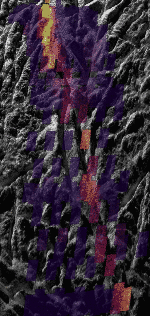
The temperature data gathered by the Cassini Composite Infrared Spectrometer (CIRS) shows how the surface along Baghdad Sulcus glows at an infrared wavelength of 10 to 16 microns. The thermal instrument has much lower resolution than the camera, so measurements appear as large colored rectangles atop the more detailed photo. The smallest features on the thermal map measure less than 1 kilometer across. The best previous map showed details no smaller than about 5 to 9 kilometers across.
The brightest colors in the map do not correspond directly to higher temperatures, but rather to a combination of higher temperatures and larger areas of warm surface material. The intensity of heat radiation increases as the color shades from violet to red to orange to yellow. No internal heat was detected in the darkest violet regions. Uncolored regions were not mapped by Cassini's composite infrared spectrometer instrument.
While the heat appears to emanate mostly from the main Baghdad tiger stripe, some of the fractures branching off or parallel to it also appear warmer and active to varying degrees, though this needs to be confirmed by further analysis. The total amount of infrared energy and the relative amounts given off at different wavelengths show that the highest temperatures along Baghdad Sulcus are limited to a region no more than tens of meters across. Most of the heat measured by the infrared spectrometer probably arises from the warm flanks of the active fractures, rather than their central fissures. The narrow central fissure is probably even warmer than the 180 Kelvin (minus 140 degrees Fahrenheit) detected -- possibly warm enough for liquid water in the fractures to be the source of the observed jets.
NASA / JPL-Caltech / GSFC / SwRI / SSI