
 Explore Worlds
 Find Life
 Defend Earth


InSight update, sols 1-24: Operations begin, first instrument deployed
Written by
Emily Lakdawalla
December 21, 2018
It’s been a busy first three weeks on the InSight mission, and they’ve already achieved a major milestone: placing the seismometer on the ground. In this post I’ll give a few brief highlights of the latest mission activities, and then go into absurd detail about mission operations and engineering. Thanks very much to principal investigator Bruce Banerdt for an informative interview full of the kinds of details that Mars geeks will love.

According to a post-deployment update posted to the JPL website, the seismometer has been placed about as far away from the lander as the arm can reach, 1.636 meters away. The next step in the long process of setting up InSight’s experiments is to level the seismometer; its placement spot has a very gentle slope of 2-3 degrees. They may (or may not) also nudge the tether ribbon slightly to minimize the noise it contributes to seismometer measurements (more on that below). After that, they’ll place a lid over the seismometer to shield it from wind, daytime heat, and nighttime cold. They expect to have the heat probe placed on the ground, about 1.2 meters to the left of the seismometer, by late January.
A couple of weeks ago, the seismometer team turned instrument noise into an unexpected bonus. They created a sound track from seismometer readings of the vibration of the lander caused by wind buffeting InSight’s solar panels. It’s both cool and a useful illustration of how important it was to get the seismometer off the deck and onto the surface.
Naturally, the sounds of Mars have already been remixed: check out Andrew Huang’s take on InSight’s minor chord.
InSight also taken lots of pictures of the surroundings, getting the first good self-portrait and 360-degree panorama. As he has done for Curiosity, image artist Andrew Bodrov produced a really cool 360-degree VR panorama for Insight. You can check this out in the browser, but it’s especially cool using VR specs, even just Google Cardboard. As far as I’m concerned, the greatest thing about this panorama is that we can see the whole spacecraft. When Curiosity takes panoramas, they almost never include the rover deck. In this immersive panorama, we can see the lander in full color, situated in its landing site.
Andrew Bodrov’s is not the only virtual reality panorama of the InSight lander available. Another is available in SteamVR.
Working in the Workspace
The first days of any lander mission involve scoping out the landing site and getting your bearings. I posted last week about the first Mars Reconnaissance Orbiter HiRISE images of the landing site, which have provided a bird’s eye view. The 360-degree panorama I shared above shows the view from the ground. I asked Bruce what he sees with his geologist’s eye in this landscape. His response: “A flat, featureless plain. Rocks are few and far between.” From orbit, “you can see that there are a lot of very subtle craters around. Some of them are right next to us, but we can’t even see them in our images very well. It’s a plain, it’s old, it’s been battered by craters for billions of years, it’s pretty well smoothed out. The exact place where we put our lander is in the middle of just a little sandy bowl.”
The “sandy bowl” they landed in is a remarkable stroke of luck. It’s pretty flat and smooth, sloping only about 2 or 3 degrees. It lacks large rocks. It’s easy material for the heat probe to penetrate. The bowl is a small crater, so that sandy fill probably only extends about a meter or two below the lander. Beneath that is regolith. Beneath the regolith is rock -- still all busted up and fractured from impacts, but otherwise relatively in place. I asked Bruce how deep the regolith goes, and he estimated 8 to 12 meters based on what you can see in orbital data. When you look at craters across the region, you can see that some craters have no blocks in their ejecta, and some do. The craters with blocks tend to be larger than 100 meters or so. We know from crater formation studies that a crater excavates material down to about a tenth its diameter to make its ejecta, so if craters have to be bigger than 100 meters across to throw big blocks out, that means the depth to the big blocks is roughly 10 meters. Here’s a little cartoon summary of what we think the ground looks like under InSight:

The most important patch of ground for InSight is the bit that lies within reach of its robotic arm, called the “workspace.” The InSight team could hardly have hoped for a better workspace. Here it is, in all its bland glory:

I love how you can see the effects of the landing rockets blasting away finer material from the surface. That's a super good sign for getting the heat probe in.
Here’s an illustration of the slope across the workspace. Note this is an unofficial product so may not be totally correct, but it’s illustrative: just a broad slope, not more than about 15 centimeters of height difference in the whole scene.

With the pictures and digital elevation models in hand, engineers working in JPL’s In Situ Instrument Laboratory spent a workday shoveling crushed granite and then landscaping it into the shape of InSight’s workspace.

ISIL contains a duplicate of InSight that they use to test every arm movement before they commit to the activity on Mars. (InSight’s body double is named ForeSight, of course. When you see pictures of ISIL, look for Mars mission Easter eggs in the background: you’ll notice the engineering model of Mars 2020’s robotic arm in some shots, and occasionally the forlorn engineering model of Opportunity.) You’ll see two areas demarcated with wooden blocks; these are the regions in which they planned to place the seismometer (to the lander’s right, the west side of the workspace) and the heat probe (to the lander’s left, the east side of the workspace).

Bruce says he actually asked the engineers if they’d have a hard time working in such an easy workspace because they’d spent all their preparation efforts learning how to work in difficult work spaces -- strongly sloped or very rocky ones. “I asked, is this going to throw them off? They just laughed.”
First Operational Weeks
For the most part, operations on InSight have been “remarkably smooth,” Bruce said. There were a “couple of hiccups” in the first week that are typical of the sorts of issues every mission has during its shakedown. On one early sol, their radio was running colder than anticipated, which shifted their transmission frequency lower than the radio stations on the ground were looking for; that cost them a sol or two.
There was an arm fault on a later sol caused by the Sun being in the field of view. InSight’s cameras have no problems imaging when the Sun is in the field of view, but the problem was that the camera had been instructed to do autoexposure, and with the Sun saturating the detector, it couldn’t calculate a useful exposure duration, so it couldn’t take the photo. The arm camera was marked “sick” by the spacecraft and Bruce said he felt a brief moment of panic when the spacecraft told the ground that its arm had been placed into safe mode, but the engineers quickly understood the problem and have developed practices to avoid the problem in the future -- either avoid imaging with the Sun in the field of view, or manually set the exposure when the Sun might be in view of the camera.
The APSS (Auxiliary Payload Sensor Suite, the weather package that’s part of SEIS) has had a few issues. Sometimes, when it’s powered on, “it spits out lots of weird stuff, and you fix that the way you fix any computer problem: we turn it off and turn it back on again.” Fortunately, APSS doesn’t often need to be turned off and on -- it usually just hums along in the background, taking data.
Apart from that, there have been no issues. They’d budgeted plenty of extra time to deal with hiccups and a difficult workspace, so as a result they’ve managed to get their first instrument deployed already.
Deploying SEIS
As you can see from this animation of the deployment of SEIS, it was very late in the day on sol 22 when they set the instrument on the ground. In fact, the Sun had already set, leaving the lander to image the deployment under dusky skies.
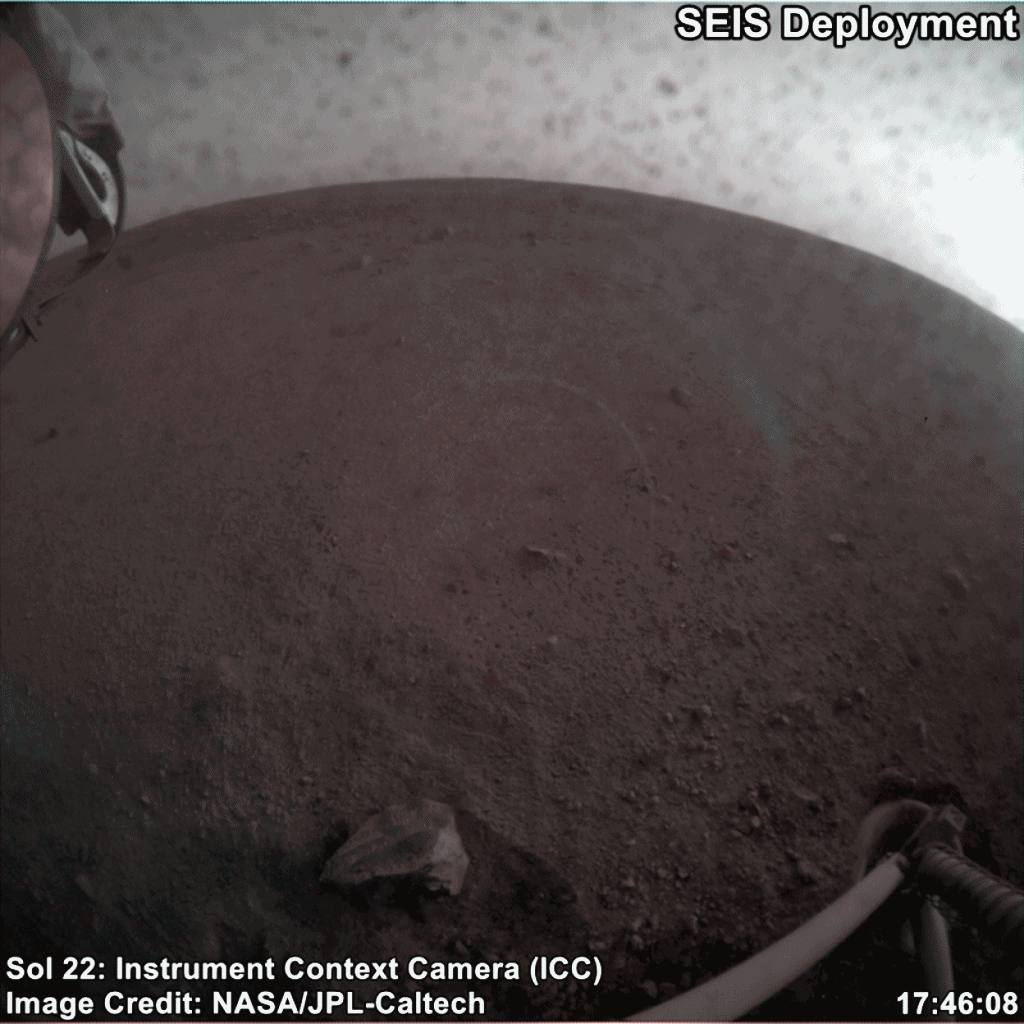
I assumed that the deployment had happened late in the day because it took a long time to go through all the steps and safety checks. But I was totally wrong! There was no “ground in the loop” for the deployment; everything was done autonomously. Bruce explained to me that the deployment needed to happen at dusk for thermal reasons. The motors in the arm have a minimum safe operating temperature of about minus 50 degrees Celsius, so the arm is typically operated during the day. But the arm’s positioning has a temperature dependence because when it gets hot during the day, the lubricant in the motors warms up, and the weight of the arm can be enough to back-drive the motors, causing the arm to droop. The warmer, the droopier. The farther out the arm reaches, and the heavier the load on the tip of the arm, the more it droops. To deploy SEIS, they had a heavy load on the end of the arm, and were operating at their farthest reach. Therefore, they wanted the arm to be as cold as possible, because at its coldest operating temperature, the arm hardly droops at all. So the maximum operating temperature for deployment was set at minus 35 degrees Celsius.
Minus 50 to minus 35 degrees is a pretty narrow range, and there are only two times of day when those ambient temperatures are satisfied: about 45 minutes at dawn and dusk. That’s why they deployed at dusk, and why they’ll likely deploy the heat probe at dusk, too. Bruce told me his biggest concern was that there wouldn’t be enough light around to image the situation after deployment, but the trusty cameras did just fine. The light was low enough that most of the images required several seconds’ exposure. As a result, you can see motion blur from the instrument’s swaying at the end of the arm. The background is very slightly blurred, too -- the load’s swinging was gently bouncing the arm.

The deployment left the grapple resting very lightly on the top of SEIS. Before they can retract the arm, they have to raise it slightly so that the grapple is no longer in contact with SEIS' upper surface. Looking at the raw images page for sol 24, I think they've managed to do that and will be ready to retract the arm on the next operational sol.
There’s one more step required to complete SEIS deployment before they put the weather lid on: adjusting the position of the cable. You can see that SEIS is connected to the spacecraft with a flat ribbon. The ribbon carries data and power, but it also has the potential to transmit vibration or other motion between the lander and the instrument, and thermal expansion and contraction of the ribbon over the course of the Martian day could also cause some noise in the SEIS data. Therefore, there is a device called a load shunt assembly between the loose part of the cable and SEIS. It’s a U-shaped stretch of ribbon (called the tether service loop) that’s currently held tightly against SEIS. Now that SEIS is on the ground, they’ll blow a small pyro device to separate the two arms of the U. Any vibrations or contraction of the ribbon will just tug on one arm of the U, and the assembly will prevent those motions from reaching SEIS. After the pyro fires, it's possible that the two arms will still be touching, although mechanically disconnected. In that event, they’ll grip a little handle farther up the ribbon and then pull the ribbon back toward the lander just a tad, making sure the arms are pulled apart. Bruce estimated about a 50% chance that they’ll wind up needing to use the arm to reposition the ribbon. The handle is designed to be gripped by the grapple but they may just use the scoop to pull the handle toward the lander just a bit. After that, they'll unroll the rest of the tether from the reel on the lander, depositing it slack on the ground. Finally, they’ll be able to place the wind and thermal shield over SEIS. If this isn't enough detail for you, you can read more about it at the SEIS website (in French, but Google translate works great).

Future Plans
Below is the schedule for instrument deployment as stated on the SEIS website. As you can see, we’re right on schedule, maybe even a bit ahead of schedule.
- Sols 0 - 5: initialization of the lander and preparation for instrument deployment.
- Sols 6 - 18 : characterization by the cameras of the room available for positioning the instruments and selection of the most advantageous potential sites for deployment.
- Sol 7 (science) : initiation of RISE data acquisition (geodesy).
- Sols 19 - 31 : deployment of the SEIS seismometer (see details below). Start of measurements in engineering mode.
- Sols 32 - 43 : deployment of the seismometer’s Wind and Thermal Shield (WTS). Start of SEIS scientific measurements (monitoring) from sol 40.
- Sols 44 - 58 : deployment of the HP3 suite. Its mission accomplished, the robotic IDA returns to a stowed position on the lander.
- Sols 59 - 69 : start of drilling operations with the HP3 mole.
In addition to InSight’s activity, you can also expect routine imaging from overhead with HiRISE. They’ll probably shoot a photo about once a month, perhaps slightly more often initially, in order to watch the fading of the blast and impact effects of InSight’s hardware landing. A side benefit of the high degree of overlap of these images is that they’ll be able to study the topography in the region near the landing site in minute detail.
An Appendix for the Real Geeks
For those of you who follow the mission happenings through the release of raw images, I have a little explainer that will help you interpret the images a little bit better. All the images have a long file name, a long string of letters and numbers. The filenames encode a great deal of information about the image. Here’s an example, with the most important parts of the filename explained and decoded. All of the images that you'll see on the website are produced from EDRs -- Experiment Data Records, a fairly raw form of the science data, though they've been lightly contrast-enhanced.

If this isn’t enough and you want to read everything there is to know about InSight mission image processing and file naming conventions, you want to read the InSight Camera Software Interface Specification (PDF).
Protect Our Shared Future
You help us defend humanity and prevent asteroid impacts. Donate now to become a Planetary Defender!
Donate