Jason DavisJan 12, 2023

Here are some of our favorite LightSail 2 pictures

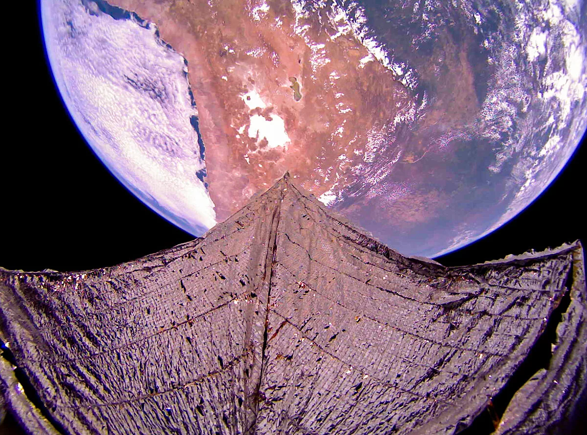
The Planetary Society’s LightSail 2 mission came to an end in November 2022, successfully completing a three-and-a-half year journey to demonstrate solar sailing for small spacecraft.

LightSail 2’s dual fish-eye cameras took numerous images to help the mission team monitor the condition of the spacecraft's shiny Mylar sails. The images also showcased the beauty of solar sailing for the public, capturing unique vistas from high above our planet.

Here are some of our favorite images from the mission, starting with a horizon-to-horizon picture of Earth prior to sail deployment, and ending with the final picture LightSail 2 sent home. Want to see more? Our image library contains many more full-size images received on Earth during the crowdfunded mission.

Pacific Ocean and Mexico from LightSail 2
Pacific Ocean and Mexico from LightSail 2 This image of Earth, which shows the Pacific Ocean with Baja California and Mexico on the right, was captured by LightSail 2 on 18 July 2019 at 21:45 UTC while the spacecraft was in range of its ground station at Cal Poly San Luis Obispo in California. Though LightSail 2's altitude is only 720 kilometers, its 185-degree, wide-angle camera lenses allow it to capture horizon-to-horizon Earth imagery.Image: The Planetary Society
LightSail 2 During Sail Deployment Sequence (Camera 2)
LightSail 2 During Sail Deployment Sequence (Camera 2) This image was taken during the LightSail 2 sail deployment sequence on 23 July 2019 at 11:48 PDT (18:48 UTC). Baja California and Mexico are visible in the background. LightSail 2's dual 185-degree fisheye camera lenses can each capture more than half of the sail. This image has been de-distorted and color corrected.Image: The Planetary Society
LightSail 2 image of the Moon and the Moonlit Sail
LightSail 2 image of the Moon and the Moonlit Sail This image taken by The Planetary Society's LightSail 2 spacecraft on Oct. 24, 2021 shows the nearly Full Moon and the sail illuminated by moonlight while the spacecraft is within Earth's shadow. This image has been color-adjusted and some distortion from the camera’s 180-degree fisheye lens has been removed.Image: The Planetary Society
Himalayas, Tibet, and India from LightSail 2
Himalayas, Tibet, and India from LightSail 2 This image taken by LightSail 2 on 31 January 2020 includes the Himalayas, Tibet, and India. North is at top. The sail appears slightly curved due to the spacecraft's 185-degree fisheye camera lens. The image has been color corrected and some of the distortion has been removed.Image: The Planetary Society
LightSail 2 image of central Australia
LightSail 2 image of central Australia This image taken by The Planetary Society's LightSail 2 spacecraft on Oct. 5, 2021 shows central Australia from the northern coast (left) to the southern coast. North is approximately at left. This image has been color-adjusted and some distortion from the camera’s 180-degree fisheye lens has been removed.Image: The Planetary Society
West coast of India from LightSail 2
West coast of India from LightSail 2 This image taken by LightSail 2 on 21 January 2020 includes the west coast of India. North is at right. The sail appears slightly curved due to the spacecraft's 185-degree fisheye camera lens. The image has been color corrected and some of the distortion has been removed.Image: The Planetary Society
LightSail 2 Orbital Sunrise
LightSail 2 Orbital Sunrise The Sun rises over the horizon in this image from LightSail 2 captured on 28 September 2019. The sail appears curved due to the spacecraft's 185-degree fisheye camera lens. The image has been color corrected and some of the distortion has been removed.Image: The Planetary Society
LightSail 2 image of Mediterranean and the Red Sea
LightSail 2 image of Mediterranean and the Red Sea This image taken by The Planetary Society's LightSail 2 spacecraft on Feb. 27, 2021 shows the Red Sea, Nile River, the eastern Mediterranean Sea, and surrounding areas. North is approximately at top right. A piece of fishing line-like material called Spectraline that held the spacecraft’s solar panels closed prior to sail deployment can be seen in the upper right and left. This image has been color-adjusted and some distortion from the camera’s 180-degree fisheye lens has been removed.Image: The Planetary Society
LightSail 2 image of Florida and the Bahamas
LightSail 2 image of Florida and the Bahamas This image taken by The Planetary Society's LightSail 2 spacecraft on Dec. 24, 2021 shows Florida and the beautiful waters of the Bahamas. North is approximately at top left. This image has been color-adjusted and some distortion from the camera’s 180-degree fisheye lens has been removed.Image: The Planetary Society
LightSail 2 Image of Typhoon Vamco and the Phillipines
LightSail 2 Image of Typhoon Vamco and the Phillipines This image taken by The Planetary Society's LightSail 2 spacecraft on 13 Nov. 2020 shows the northern Philippines and Typhoon Vamco. North is approximately at upper right. Spectraline (fishing line type material) that originally held the spacecraft panels closed can be seen in the lower right and left. The image has been color-adjusted and some fisheye lens distortion has been removed.Image: The Planetary Society
LightSail 2's Final Image
LightSail 2's Final Image This image taken by The Planetary Society's LightSail 2 spacecraft on October 24, 2022 was the final image returned from the spacecraft before atmospheric reentry. It shows the central portion of South America centered approximately on Bolivia including the large, white Uyuni Salt Flats. North is approximately at top. This image has been color-adjusted and some distortion from the camera’s 180-degree fisheye lens has been removed.Image: The Planetary Society

Let’s Go Beyond The Horizon

Every success in space exploration is the result of the community of space enthusiasts, like you, who believe it is important. You can help usher in the next great era of space exploration with your gift today.

Donate Today