
 Explore Worlds
 Find Life
 Defend Earth


Mars Exploration Rovers Update: Opportunity Digs In at Matijevic Hill
Sols 3119 - 3147

Written by
A.J.S. Rayl
Contributing Editor, The Planetary Society
December 3, 2012
Mars Exploration Rover
NASA / JPL-Caltech / Maas Digital
While Curiosity and her team found themselves entangled in a media furor over comments, assumptions, and rumors of findings that have yet to be found, Opportunity roved on in November, finishing up the geologic survey of Matijevic Hill and setting a new mileage record along the way. Now, as the Mars Exploration Rover (MER) mission closes in on its ninth anniversary of exploring the Red Planet, the veteran rover is in the "sweet spot," grinding in to chosen rock targets, which just may be harboring the smectite clay minerals that orbital data indicate are somewhere beneath its wheels on Matijevic Hill.
Opportunity began its geologic survey of Matijevic Hill, which is located in the Cape York segment of the rim overlooking Endeavour Crater, in October, at a rock dubbed Whitewater Lake, a light-tone, flat rock that features splotches of an unusual coating on it. Although the rover is still 15 to 20 meters away from that rock, it is now surrounded by rocks that appear to be just like Whitewater Lake.
"The survey is finished," announced Ray Arvidson, deputy principal investigator, of Washington University St. Louis. "We have circled almost back to Whitewater Lake, but not quite," he added.
Since the scientists have chosen the targets they want the rover to examine up-close and the rover can now see Whitewater Lake, he said, the MER science team members decided it was time for Opportunity to dig in and get to the scientific sleuthing that will enable them to unravel the geologic mystery of what happened here on Mars during the last three to four billion years or so.
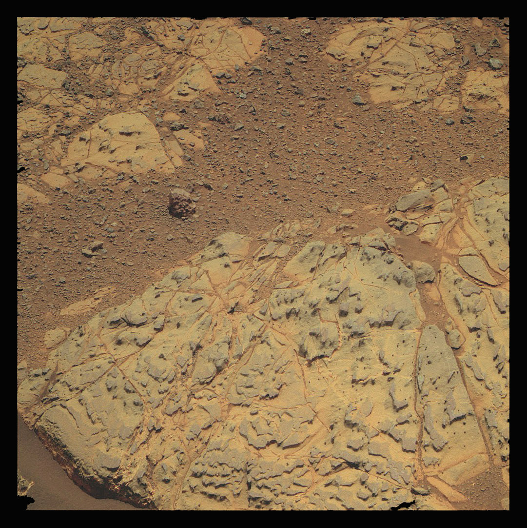
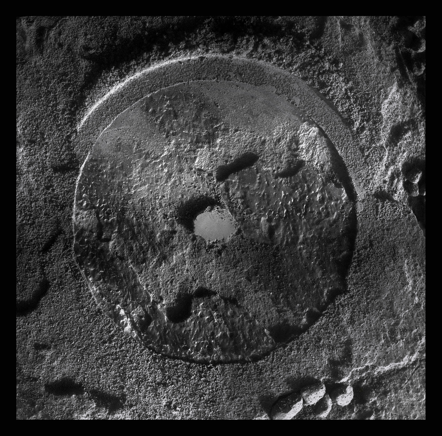
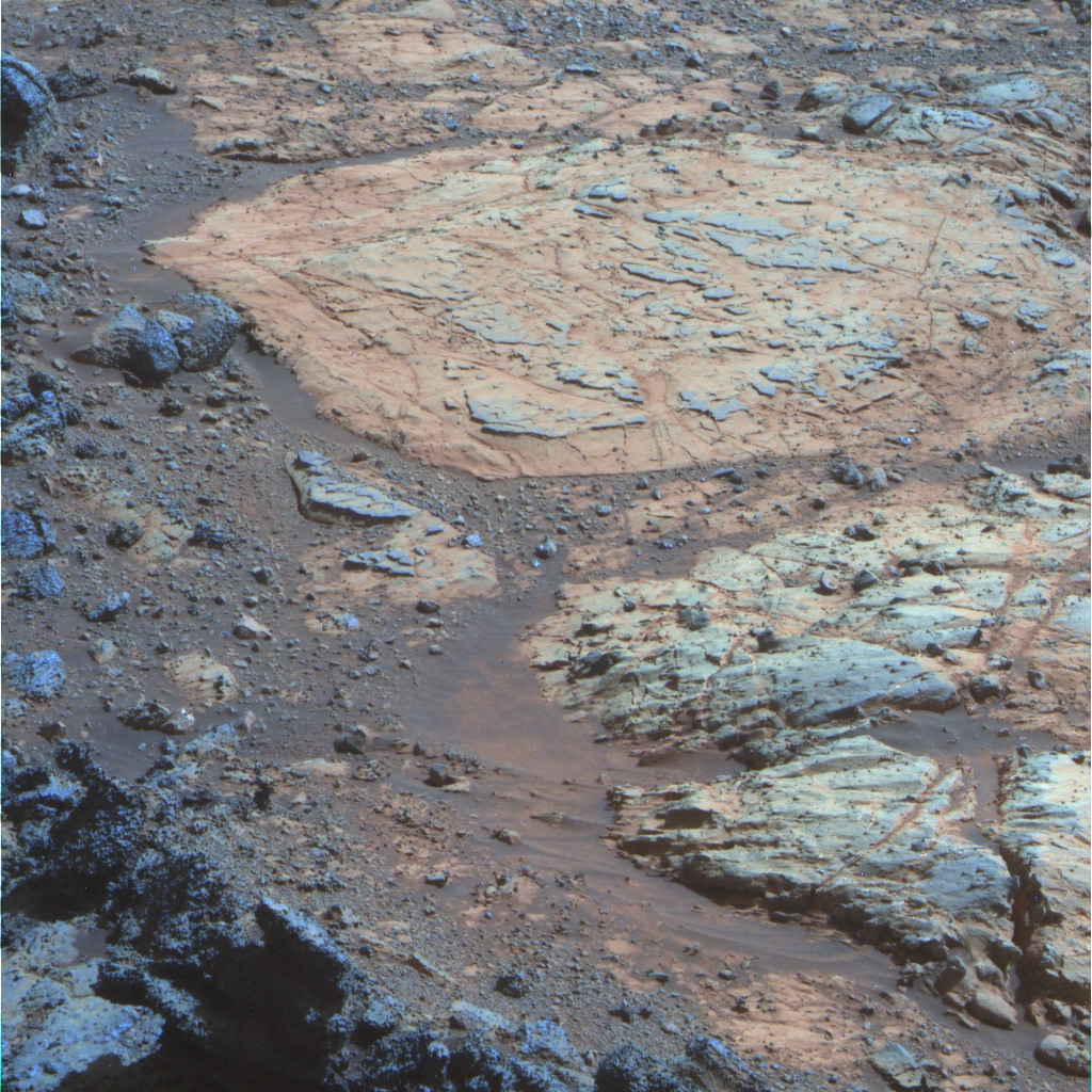
Whitewater Lake-like rock
This image, processed by Stuart Atkinson, of UnmannedSpaceFlight.com, shows one of the light-tone, flat Whitewater Lake-like rocks that Opportunity now sees all around her. For more of Atkinson's work, please see his On the Road to Endeavour blog.NASA / JPL-Caltech / Cornell / UA / S. Atkinson
The robot field geologist is currently parked near one of those flat Whitewater Lake-like rocks and using its instruments to check it out. It's been at this rock since the Thanksgiving holiday, taking close-up pictures with its microscopic imager (MI) and looking at the weird coating on a spot the team dubbed Sandcherry with its alpha particle X-ray spectrometer (APXS) to try and determine its composition. It may be that this rock is part of an extensive layer that includes the first Whitewater Lake rock and the other similarly coated rocks around it - and it may be where the smectite is hiding.
"On our primary list of what to do is trying to see how extensive areally this Whitewater Lake material is, because it's the one unit that is big enough to hold the smectite signature we're seeing from CRISM," said Arvidson. The Compact Reconnaissance Imaging Spectrometer for Mars, known simply as CRISM, is a visible-infrared spectrometer aboard the Mars Reconnaissance Orbiter (MRO) designed to search from above for mineralogic indications of past and present water on Mars. Arvidson serves as a co-investigator on that instrument in addition to his MER duties.
In brief, smectite is an iron-magnesium clay mineral, usually white, green or gray in color on Earth, belonging to a class of silicate minerals known as phyllosilicates. Finding clay minerals of any kind is a big deal for Opportunity for the simple reason that clay minerals are evidence of past water that was neutral to alkaline, water much more suitable for the emergence of life than the past highly acidic water for which both Spirit and Opportunity found evidence during their prime mission in 2004 - and because finding clay minerals was never on the MER list of science goals, but it is on Curiosity's science objectives list, and what's life without a little friendly competition between rovers on Mars?
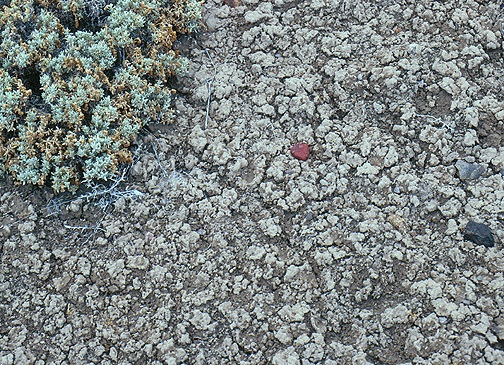
Smectite on Earth
Opportunity is on the hunt for the clay mineral smectite on Matijevich Hill and the story behind how it formed. One theory is that it is the end result of an impact that produced an enormous amount of heat and steam, which then transformed some of the ejecta to clay. Time and more investigation will tell. Meanwhile, this is a close up image of the crinkly, cracked surface typical of a soil rich in smectite clay on Earth.University of Pittsburgh / Norris W. Jones
Matijevic Hill is Opportunity's Mt. Sharp, the scientifically golden destination for Curiosity, as Steve Squyres, MER principal investigator, of Cornell University, put it. But actually identifying the smectite will take some work. "We are essentially living through what our friends on Curiosity are going to be doing too, but with a payload is somewhat challenging for finding minerals of a given flavor," said Squyres.
"It's much more detective work now," underscored Arvidson, just as he has noted several times in previous MER Updates. "We don't have the miniature thermal emission spectrometer (Mini-TES), which would see clay minerals immediately. We don't have the M"ossbauer spectrometer, which would see the iron-bearing mineral phase." Therefore, the MER science team's conclusion will have to be based on "the composition, the overall geologic setting, and a little bit of color, and correspondence with what we are seeing from CRISM observations," he said.
Best guess at this point?
"Although the smectite could be shed down hill in the soil, in the end, I think the Whitewater materials are the areally extensive unit and compositionally the best bet to have this altered phase," ventured Arvidson.
During the past week, Opportunity brushed the notorious Martian dust off the target Sandcherry and then grinded into it with its rock abrasion tool (RAT), just about a millimeter, taking images and composition measurements after each action.
"We've started the IDD campaign at Matijevic Hill and that's what the rover is doing now," said John Callas, MER project manager, at the Jet Propulsion Laboratory (JPL), homebase for all the American Mars rovers.
While parked at the new Whitewater Lake-like outcrop taking the Sandcherry measurements, Opportunity is also taking hundreds of images with the stereo panoramic camera (Pancam) that with be processed into the next big panorama. "The imaging for the Matijevic Panorama should be completed in the next few days," said Arvidson.

JPL-Caltech
Jake Matijevic (1947-2012)
Jacob "Jake" Matijevic, one of the original Mars rover pioneers, worked at NASA's Jet Propulsion Laboratory (JPL) since 1981 and was involved in the creation and success of every American Mars rover. He led the engineering team for the first Mars rover, Sojourner that landed in 1997; was a member of the original group that proposed MER and then led the engineering team for Spirit and Opportunity for several years before and after their landings. And at the time of his death in August, he was chief engineer for surface operations systems for Curiosity.But it may take a few weeks for it to be processed. "We will finish 'acquiring' the Matijevic Panorama soon, but there's still more than 50% of it on the rover awaiting downlink," pointed out Jim Bell, the lead scientist for the MER stereo panoramic cameras (Pancams), Planetary Society President, and professor at Arizona State University (ASU). "It will be a while longer before I'm able to put it all together," he said.
Matijevic Hill is named for Jake Matijevic, the beloved mathematician-systems engineer at JPL who was deeply involved with the creation and surface operations of Sojourner, Spirit and Opportunity, and Curiosity, as covered in the August and September editions of the MER Update.
Jake, who may well have known more about how Mars rovers work than anyone and appeared frequently in the "pages" of the MER Update over the years, passed away unexpectedly in August, just a couple of weeks after Curiosity landed. And so, this panorama, like the Greeley Panorama, named for MER science team member and planetary science mentor and friend Ron Greeley of Arizona State University (ASU), who passed away in October 2011, also unexpectedly, is personal, said Bell.
"Jake was a gentle genius - always willing to authoritatively answer questions from folks like me who are relatively naive about the detailed engineering aspects of rover design and operations," Bell reflected. "Conversely, I found him to be consistently interested in, and often delighted by, the scientific discoveries being made with the help of the robots and systems that he helped to design, build, and operate. Those of us who knew and worked with Jake at JPL miss his wisdom and insight. "We hope that one small way to honor his contribution and legacy is by taking spectacular landscape photographs like the Matijevic Pan showing the beauty, as well as the scientific potential of one of the many places that he helped to explore."
Throughout November, Opportunity performed flawlessly, true to her MER spirit. "The rover did drive quite a bit this month and she's doing just fine," reported Bill Nelson, chief of the rover engineering team at JPL.
NASA / JPL-Caltech / Cornell / ASU
A view of Matijevic Hill 3D
On the horizon in the right half of this panoramic view is Matijevic Hill, named in commemoration of Jake Matijevich, a JPL pioneer in creating robots to rove on Mars. The view appears in three dimensions when viewed through blue-red glasses (red lens on the left). Opportunity snapped the images that are combined into this view with the navigation camera on her Sol 3054 (Aug. 26, 2012), just a couple of weeks after she pulled up to the western rim area of Endeavour Crater. The left side of the panorama shows portions of the rim farther south.A couple of events that could have spelled big trouble for Opportunity turned out to be, all things considered, rather pleasantly uneventful. The first involved Mars Odyssey, the aging, workhorse orbiter that is the primary communication link for MER. A few months back, Odyssey, which is well into extended missions and operating way past its "warranty," lost the use of one of its three reaction wheels (the flywheel-type system with which it maintains attitude control so it doesn't have to rely on the fuel-guzzling rockets all the time) and had to switch over to its spare reaction wheel.
In early November, Odyssey underwent what effectively is "almost like a brain transplant," as Callas put it, what they call a 'side-swap' in rocket scientist jargon, switching its relay system from its Side-A to Side-B, a redundant system.
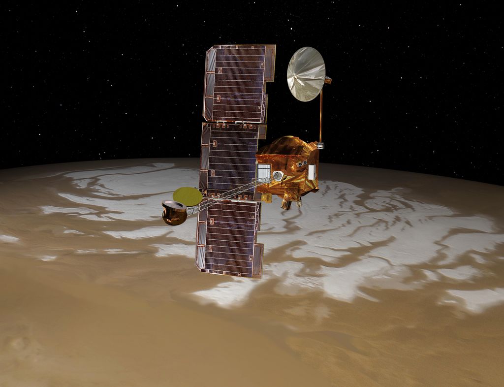
Mars Odyssey
The Mars Odyssey spacecraft passes above Mars' south pole in this artist's concept illustration. The spacecraft has been orbiting Mars since October 24, 2001 and serves as Opportunity's primary data relay link.NASA / JPL-Caltech
It sounds simple enough, switching from A to B, from one to the other. "But it's a little more involved," said Callas. "It's like having two brains and switching one from the other, but they have to shut down everything on one side and then boot up everything on the other side. It's dicey, because the 'B-side' [failsafe, redundant system] had not been used since before launch," he explained. "The good news is it hadn't been used in more than 10 years."
Odyssey's "brain transplant" took the orbiter out of communication commission for several days, so Opportunity turned her UHF radio toward MRO to downlink her data to Earth. "While Odyssey was unavailable, we were using MRO exclusively for that entire period," said Nelson.
By November 11th, Odyssey was back in the saddle, and back to "delivering the mail every single day," as Callas put it. "Odyssey had an aging gyro [reaction wheel] on the A side and a heavily used relay system - and now it has a very little used gyro on the B side that's working well, and effectively a brand new UHF relay on the B side and we're excited about that," he said.
Just a couple of sols later, Opportunity began to detect an increase in dust or atmospheric opacity in the skies overhead, what the MER team calls "Tau." At the same time, the Mars Color Imager (MARCI) team on MRO was observing a large regional dust storm, with high atmospheric opacity in the center of the storm, heading in the direction of the rover.
"Every two Mars years, on average, we get these big dust storms, so we were kind of due for one and were wondering what might happen here," said Callas. "The MARCI team were very vigilant in giving us daily email updates and we were watching the storm."
The storm "moved south through Isidis and Syrtis Major and into the southern hemisphere, where it spread south, east and to the west," noted the weekly MARCI weather report posted by Malin Space Science Systems (MSSS). It "extended from the southern tropics in the north to the seasonal polar cap edge in the south and from Promethei in the east to Noachis in the west, [and] covered about 10.4 million squared kilometers."

Planet-encircling dust storm of 2001
These Hubble Space Telescope images show the Red Planet before (left) and during (right) the great Martian dust storm of 2001. This Martian dust storm, larger by far than any ever seen on Earth, has raised a cloud of dust that engulfed the entire planet for several months. Fortunately for Opportunity and Curiosity, the regional storm that spread across the Red Planet in November didn't go large.NASA / Hubble Space Telescope
The MER ops team remained on storm watch over the weekend of November 16th-18th. "We were not seeing the Tau levels become elevated in a way that would suggest we were in the crosshairs - at least the few days of concern we appeared not to be experiencing anything too much out of the ordinary," said Nelson. "But we didn't know that was how it was going to play out."
By the end of that weekend, Mars calmed down and the dust storm system began to weaken, "contracting in the southern tropics and in eastern Promethei, indicating the storm was not going to become a planet-encircling event," according to the MARCI weather report.
The storm eventually passed to the south of Opportunity and never got any closer than about 1300 kilometers (807.78 miles), according to the MARCI team. Still, both Opportunity and Curiosity, on the other side of the planet, "experienced elevated atmospheric dust levels as a result of the storm, similar to atmospheric opacity levels experienced on typical hazy summer day in Los Angeles," according to the MARCI weather wrap-up for that week.
Technically, Opportunity's power levels dropped about 60 watt-hours as a result of the storm, from 600 watt-hours to about 539 watt-hours. Not too bad really. And, by month's end, the rover was back to producing around 560 watt-hours, more than half its full capability.
The devil on Mars, however, is in the dust and as the powdery stuff from storm began to rain down, Opportunity saw an increase in the haze overhead. "The storm did elevate the atmospheric opacity, and things are a little dustier now," confirmed Callas. "We're seeing more dust settling on the solar arrays, which I don't like. But that's just the reality of operating on Mars."
Digging into Sandcherry
During the last week of November 2012, Opportunity used her rock abrasion tool (RAT) to grind about 1 millimeter into Sandcherry, into a target on a Whitewater Lake-like rock, one of many that are now all around the rover. The spot that the rover dusted is actually part of the weird coating or rind that distinguishes these flat rocks. Stuart Atkinson processed the series of microscopic imager pictures that went into this mosaic. Time will tell is these rocks are harboring the smectite clay minerals that for which Opportunity is now on the hunt.NASA / JPL-Caltech / S. Atkinson
Opportunity carried on undaunted, ready to dig into her work over the American Thanksgiving holiday, while her colleagues were dining on turkey or tofurkey and marshmallow topped yams. But sometimes, it would appear, rovers need a break too.
The robot field geologist was slated to brush the dust off Sandcherry during the holiday weekend, but as she began to slowly move her instrument deployment device (IDD) or "arm," one of the shoulder joints cause a stall that stopped that plan.
When the MER team members returned to work after the holiday, they looked at the telemetry and went to work to figure out what happened. It turned out to be a glitch the engineers had seen before, a matter basically of movement logistics with the IDD during the attempt to place the rock abrasion tool (RAT) on Sandcherry. "We did a diagnostic and everything seems fine," said Callas, noting that the rover completed the Sandcherry brushing Tuesday, November 27th, as commanded. "So far, the IDD looks in good order, but things like this are always a concern," he said.
All's well that ends well, as the adage goes, and for MER November 2012 ended well. In preparation for its subsequent grind into Sandcherry, Opportunity had taken some pictures of the RAT's grind bit. "It's still looking great," reported Gale Paulsen, a systems engineer at Honeybee Robotics, the company that manufactured the RAT. Then Thursday evening, November 29th, shortly after the images of the rover's grind into Sandcherry streamed down to Earth down, he added: "The grind looks good!"
And so the MER mission is roving on, ever closer to its 9th anniversary in January 2013, with Opportunity now into her 107th month of roving Mars and doing anything but slowing down. In fact, despite all the years of roving, this robot field geologist is keeping her team on Earth as busy as ever.
In coming sols, Opportunity will be checking out other chosen targets on Matijevic Hill to try and understand more about Mars' ancient past. "We have a lot more to do," said Arvidson. "We're only right in the middle of this whole process."
From finding out what created the mystery spherules or "newberries," as Squyres initially referred to them - which the rover discovered in its first Matijevic Hill target, the Kirkwood outcrop - to finding the smectite, the rover and the MER scientists have a full agenda before them and every intention of delivering more textbook science in the months to come.
Opportunity from Meridiani Planum
As November dawned at Meridiani Planum, Opportunity was continuing her geologic survey around Matijevic Hill.
The rover spent much of the first week of the month driving, with a series of short jaunts to the south-southeast on Sols 3119, 3121, and to the south on 3124 (November 1, 3, and 6, 2012), putting 38 meters (125 feet), 25 meters (82 feet), and 30 meters (98 feet) respectively on her odometer. Just like she's done throughout the survey, Opportunity took a number of pictures with her Pancam before each drive, and then following the drives, she took a 360-degree panorama with her navigation camera (Navcam).

Opportunity's Route
This route map shows Opportunity's travels up to its Sol 3135 (Nov. 17, 2012), and the rover's approximate current location on Matijevich Hill, a rise on the inboard side of the Cape York segment of Endeavour Crater's western rim. This image was produced by Eduardo Tesheiner, of UnmannedSpaceflight.com, who created it from images taken by cameras onboard the Mars Reconnaissance Orbiter. As this map shows, Opportunity made some tracks around Matijevich Hill in November, the rover's Sols 3119 to 3147.NASA / JPL / UA / MSSS / E.Tesheiner
In addition to driving and conducting her routine science and engineering tasks, the robot field geologist worked in an atmospheric argon measurement with her Alpha Particle X-ray Spectrometer (APXS) on Sol 3122 (November 4, 2012), and two direct-to-earth (DTE) X-band sessions on Sols 3120 and 3122 (November 2 and 4, 2012).
"We do these DTE sessions in part just to get time packets, and the type of data that allows us to measure the time delay between the spacecraft clock and real time," noted Nelson. "It is a routine thing. We try to do this at least once a week. However, since we perform these over 70-meter dishes, which are relatively hard to come by for an extended mission like us, and with the DSN schedules being what they are, we have to take what we can get."
The MER engineers also implemented a new daily nadir check sequence that serves to significantly reduce the number of power cycles on the rover's inertial measurement unit (IMU). "A nadir check uses the accelerometers to determine the gravity vector, i.e. it find the direction of 'straight down,'" said Nelson. "There are three accelerometers, one along the X, the Y and the Z-axes. For a perfectly level rover, only the Z-axis accelerometer would register anything. But a tilted rover will show gravity-induced accelerations in one or both of the other directions. Working backwards, we can use a nadir check to tell the true gravity vector relative to the tilted rover," he explained.
"The old nadir check turned the IMU on, did its observation and then turned the IMU off, resulting in net IMU cycles of 3," Nelson continued. This was usually sequenced as part of a drive with the order being:
Start "backbone" or overall drive sequence
Call the drive setup sequences
Call a pre-drive nadir check (one on-off IMU power cycle)
Turn on the IMU (another 1/2 cycle)
Do the drive
Turn off the IMU (yet another 1/2 cycle)
Call a post-drive nadir check (still another on-off IMU power cycle)
Call the drive teardown sequences
End the "backbone" sequence
In the new scheme, Nelson said, the nadir check sequence assumes the IMU is on and does nothing to it, resulting in net IMU cycles of 1. Sequencing is then done this way:
Start "backbone" or overall drive sequence
Call the drive setup sequences
Turn on the IMU (a 1/2 cycle)
Call the new nadir check (no IMU power cycle)
Do the drive
Call the new nadir check (no IMU power cycle)
Turn off the IMU (another 1/2 cycle)
Call the drive teardown sequences
End the "backbone" sequence
"Note that the IMU is actually on slightly longer, but doesn't switch power," Nelson pointed out. "Just like other equipment, the IMU is most likely to fail during a power transient. People will likely remember that light bulbs are most likely to fail when you switch them on or off, not while they're just sitting there quietly shining."
MER body parts
The Mars Exploration Rovers act as robot geologists while they are on the surface of Mars. This image shows the rover's various parts and instruments. In some senses, the rovers parts are similar to what any living creature would need to keep it "alive" and able to explore.NASA/JPL-Caltech
All in all, it was a good week and things were looking bright for this aging rover. Opportunity began the month producing about 550 watt-hours of power and by week's end was sporting 586 watt-hours. The sky overhead was only slightly hazy, with the rover reporting an atmospheric opacity or Tau of 0.605. Her solar array dust factor of 0.604 had remained fairly stable from the end of October.
As the first week of November was coming to an end, MRO moved in to provide Opportunity with exclusive Ultra High Frequency (UHF) relay support while Mars Odyssey went off-line to conduct the side-swap of its avionics and relay system from it's A-side to its B-side or redundant system. But if it wasn't broken, why fix it?
"Odyssey was approaching 'end of life' on some of its A-side components and rather than let those components fail at a random time, the orbiter project members decided they were close enough to the switch point that they would like to control the change-over [to the B-side or its redundant system] by forcing a side-swap, which is what fault protection [on failure of that system] would have done anyway," explained Nelson. And just as the orbiter adjusted to its "new" wheel, it also took to its new "brain."
In the meantime, "MRO provided complete support for MER," added Callas, "and that worked well."
Opportunity began the second week of November on Sol 3126 (November 8, 2012) by taking some pictures of the bit on her Rock Abrasion Tool (RAT) - which showed the instrument to be in "great" shape," as Honeybee's Paulsen reported - and collecting a routine set of Microscopic Imager (MI) sky flat calibration images. Then, she revved up her "engine" and drove on, logging 34.5 meters (113 feet) on Sol 3128 (November 10, 2012), and another 16 meters (52 feet) on her Sol 3131 (November 13, 2012). Collecting the usual pre-drive Pancam pictures and after-drive Navcam panoramas.

Cape York from CRISM
This image is actually a geological and mineralogical map of Cape York taken by the Compact Reconnaissance Imaging Spectrometer for Mars (CRISM) instrument onboard MRO, which is searching for mineralogic indications of past and present water on the Red Planet. The location of the smectite clay mineral signatures CRISM detected are displayed in red. Stuart Atkinson, of UnmannedSpaceFlight.com, plotted Opportunity's path. You can see that the rover is in the "sweet spot" for finding the clay minerals. For more of Atkinson's work, please visit his On the Road to Endeavour blog.NASA/JPL/UA/JHUAPL
On the Sol 3131 drive, Opportunity passed the 22-mile mark. The rover now has Lunokhod 2's record squarely in her sites. Although the Russian Moon rover only operated for about four months, it traveled 23 miles (37,014.91 meters) and it's the only rover distance record left for Opportunity to best. "We ended that drive at 35,428.83 meters, which is just a little bit beyond the 35,405.57 meters of 22 miles," Nelson noted for the record.
Between drives, on Sol 3129 (November 11, 2012), the robot field geologist conducted a routine atmospheric argon measurement with her APXS. That same sol, Odyssey came back online after its avionics side-swap and sent a fresh round of data back to Earth. The relay pass using the new Side-B transceiver on Odyssey was "nominal," according to various JPL reports, and Opportunity and Odyssey got back to their normal communication routine.
The rover experienced a little bump in power during the second week of November and power levels increased to 596 watt-hours, as the Tau decreased to 0.589, and her solar array dust factor registered at 0.606. On Sol 3132 (November 14, 2012), Opportunity finished the week with an 8.5-meter (27.9-foot) drive, to effectively complete the survey of Matijevic Hill.
"We almost closed the loop, driving north and then counterclokwise back around toward the original entry point at Whitewater," said Arvidson. "Actually it's more like a big rectangle and we've been driving counterclockwise, to come almost full rectangle, if you will . . . we can see Whitewater and Kirkwood, the original outcrop we looked at on Matijevic Hill, from where we are, although we are still 15-20 meters away."
As Opportunity was conducting the geologic survey of Matijevic Hill, MER science team members were eyeing a number of outcrop targets and rocks along the way that they wanted the rover to return to for more in-depth investigations. As the third week of November took hold, they wasted no time in directing their charge.
Surveying Matijevic Hill
As November 2012 began, Opportunity was still in the midst of her geologic survey of Matijevic Hill. Along the way she cruised by another small crater, one of a good number of craters created by meteoroid impacts into the edge of Cape York segment of the Endeavour Crater rim, seen here in an image processed by Stuart Atkinson.NASA/JPL-Caltech/S. Atkinson
The robot field geologist roved right from the second week into the third week of November on Sol 3133 (November 15, 2012) with a 24.6-meter (80.7-foot) drive to approach a Whitewater Lake-like rock, splashed with the same kind of weird coating or rind that was on the first Whitewater Lake rock that she has examined in September. The rover then followed her commands to "bump" into position with an 80-centimeter (31.49-inch) forward move on Sol 3135 (November 18, 2012).
The following sol, 3137 (November 19, 2012), Opportunity began her in-situ investigation on Sandcherry, the chosen surface target on the flat, Whitewater Lake-like rock. As usual, she first took a series of pictures with her MI for to be mosaicked into one image, and followed that by placing her APXS down on the target to try and tease out its composition.
As Opportunity shifted gears from conducting the survey to digging in, a regional dust storm had "extended from the southern tropics in the north to the seasonal polar cap edge in the south and from Promethei in the east to Noachis in the west, covered about 10.4 million squared kilometers," according to the MARCI weather report posted by Malin Space Science Systems (MSSS).
Although the "the storm system already showed signs of weakening" by the time Opportunity began checking out Sandcherry, the rover was seeing an increase in Tau or atmopsheric opacity. On Sol 3136 (November 19, 2012), her energy was down to 539 watt-hours and atmospheric opacity was up to 0.897, while her solar array dust factor registered 0.612. "We did see a run-up in optical depth," said Nelson. "It jumped from about .6 -.7 up to about .9. But the Tau has been slowly dropping down since."
Since the storm passed by Opportunity from a distance of 1300 kilometers (807.78 miles), it might be something of an overstatement to say that the rover "dodged a bullet," but as every Mars explorer and robot knows - especially Opportunity, who almost lost her "life" during a planet-encircling storm in June-July 2007 - anything can happen on Mars anytime and often it does. This time it didn't and everyone breathed a sigh of relief.
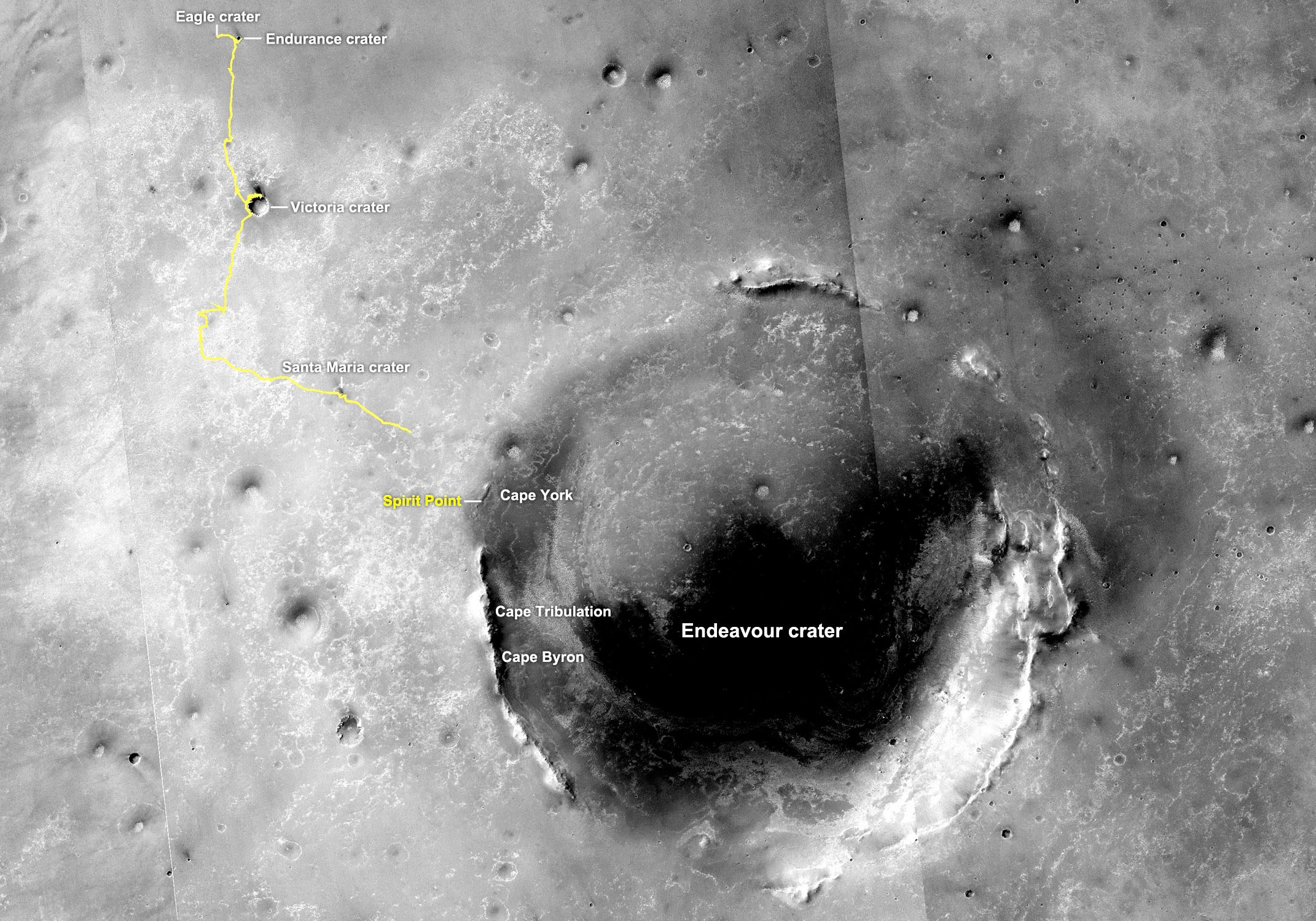
Endeavour Crater orbital view
This image of Endeavour Crater was taken by the Malin Space Science Systems' Context Camera, which is onboard the Mars Reconnaissance Orbiter. The yellow line on this map shows the route Opportunity took from Eagle Crater, where the robot field geologist landed in January 2004 (at the upper left end of the track) to a point about 3.5 kilometers (2.2 miles) away from the rim of Endeavour Crater. The rover arrived at the 22- kilometer (14-mile) diameter hole in the ground in August 2011, after a three-year journey from Victoria Crater. The rover entered by way of Spirit Point, an area named after her twin "sister," which stopped communicating in March 2010.NASA /JPL-Caltech / MSSS
The concern now is that all the dust that goes up must come down and Opportunity is in the fallout zone. Although the rover was graced by numerous dust-cleaning wind gusts during the last several months, the desired dust-guster winds are winding down as spring heads for summer in the southern hemisphere on Mars.
"We're kind of past the historical period of cleaning events for the rover," said Callas. "It doesn't mean they can't happen, but we pretty much got through our cleaning events after winter. One always hopes these winds will completely clear off the solar arrays, but they never quite clean off all the dust the rover accumulated in the previous year. So we do see this secular downward trend in solar array performance, because the dust never quite gets 100% cleaned off, and each year there's a little bit more."
As Americans took off for the annual Thanksgiving holiday, Opportunity was scheduled to work. The plan for the rover's Sol 3139 (November 22, 2012), was for her to brush the Sandcherry target with her RAT, take more pictures with her MI and then put her APXS down for a good long integration over the long weekend. But that didn't happen. While Opportunity initiated the sequence and began to slowly move her IDD or arm to get the instrument down, she suffered a stall in her shoulder elevation joint and that automatically stopped all further IDD activity.
"We tried to brush last week, so Opportunity could then get a good APXS integration over the holiday, but when we came back Monday, there was a joint stall on one of the IDD joints," recounted Arvidson.
"It was a Joint 2 stall, the shoulder elevation joint," Callas specified. "You recall, we stopped using Joint 1 [also on the shoulder] because it's become so arthritic. We know we have a broken lining in that joint and we don't want to get stuck in an inappropriate position, so we haven't used Joint 1 in years. Every once in a while we get a stall Joint 2 when we are doing very slow motion of the arm during placement, when we want to do a precise placement. That's what happened this time," he explained.

JPL-Caltech / S. Atkinson
Completing the survey
The pictures that went into this image were taken by Opportunity in mid-November 2012 as the robot field geologist was completing her geologic survey of Matijevic Hill. If you click to enlarge, you can see the rover's tracks on the far right, going up the side of Cape York leading to the Kirkwood outcrop, and on the far left you can see her tracks leading back towards Whitewater Lake in this picture processed by Stuart Atkinson."We've only seen a few occurrences of this and we believe we understand it, namely, this particular move was done at a very slow speed with small amount of motion," confirmed Nelson. "When we're doing things at slow speed like that, we have to overcome the magnetic detents that would normally help guide you into position when you're not powering the joint. It's a good thing when you want to stay in one place, but a bad thing when you want to move the IDD, and the combination of the particular angle it was at, the speed, and the small motion resulted in it kind of getting caught in the magnetic detent and not moving when commanded."
As a result of the joint 2 stall in her IDD, Opportunity got something of a break over the Thanksgiving weekend, though their was no tofurkey or mashed potatoes on her table. "We had expected to do a RAT brush and MI imaging and an APXS integration over last weekend, and because of that we did the APXS integration, but it wasn't down on the rock, so the sequenced APXS measurement on Sol 3140 (November 23, 2012) fortuitously ended up being an APXS argon integration," said Nelson. "It wasn't a total loss. We just didn't get what we wanted."
Whitewater Lake
A rind that appears bluish in this false-color view of Whitewater Lake covers portions of the surface of this rock and others like it around Matijevich Hill, along the inboard side of the Cape York segment of the rim of Endeavour Crater. Each of the three rock types the MER scientists are now analyzing and trying to sort out appear in this image. Whitewater Lake is the large flat rock in the top half of the image, and from left to right it is about 0.8 meter (30 inches) across. The dark blue nubby rock to the lower left is Kirkwood, which bears non-hematite spherules or "newberries," as Steve Squyres initially dubbed them. The rocks to the lower right look like breccias -- a type of rock containing jumbled fragments cemented together, resembling other rocks in the area classed as the Shoemaker Formation, which may hold deposits of material ejected when an impact excavated Endeavour Crater billions of years ago. Opportunity took three exposures through different filters with her Pancam on her Sol 3064 (Sep. 6, 2012). Those exposure were then were composited into this picture. The view is presented in false color that enhances differences among various geological materials in the scene.NASA/JPL-Caltech/Cornell/ASU
The MER engineering team reviewed all the associated telemetry from the stall event and found no indication of any change in the health of the joint, so when the MER ops team members convened on Monday, November 26th, they decided to simply re-do the plan. "But we decided to change one tiny piece of it, to take out that small motion," Nelson informed. And, just to make sure the joint was okay, the team also included a diagnostic move at the start of the plan on the rover's Sol 3144 (November 27, 2012). It, too, showed a nominally functioning joint. "Our theory about what was wrong appears to be born out," said Nelson.
Opportunity carried on and successfully completed the brushing Sandcherry that same sol. And as per the routine, she followed that brush by taking the usual pictures for an MI mosaic and then placing her APXS down on the target to analyze the composition of this strange coating or rind.
With the successful brushing behind her, the robot field geologist put her RAT down on Sandcherry one more time, but this time grinded about 1 millimeter into the approximately 2 millimeter-thick coating on the rock. The RAT functioned beautifully, according to Honeybee's Paulsen. "We didn't see any appreciable wear of the bit after this grind and haven't seen much wear for the past few years," he told the MER Update.
"We're very interested in Sandcherry, the coating on top of this Whitewater-like rock, because we've never seen anything like this before, because the coating probably formed in the presence of water, and because right beneath the coating are veins cutting through Whitewater," said Arvidson.
What the MER scientists find in Sandcherry will likely tell them a lot, like where the smectite is - or not, for starters. The answer won't come easy. "We can't see any excess hydrogen in Whitewater, but, on the other hand, from CRISM we don't see much bound water, so it's a dry outcrop no matter what," said Arvidson. "And we have no mineralogical capabilities that would do a direct detection of clay minerals, so it is going to take a lot of detective work," he reminded.
While it certainly looks like Sandcherry's rock is part of a greater Whitewater Lake layer, the jury is still out on that too. "I suspect it will be, but we don't know for sure yet," said Arvidson. "It really does look the same, but that's why we stopped here and why we're making the measurements now, to see if it is the same."
Since parking over the new Whitewater Lake-like rock and positioning herself in front of Sandcherry, Opportunity has also been snapping lots of pictures with her Pancam, hundreds of pictures for the MER mission's next super-sized image, the Matijevic Panorama. The rover should complete principal photography this weekend or early next week and soon Bell and his colleagues on the Pancam team will be working on stitching the really big pic together and producing the next breathtaking view of the alien planet that looks somehow so familiar.
NASA/JPL-Caltech/Cornell/ASU/S. Atkinson
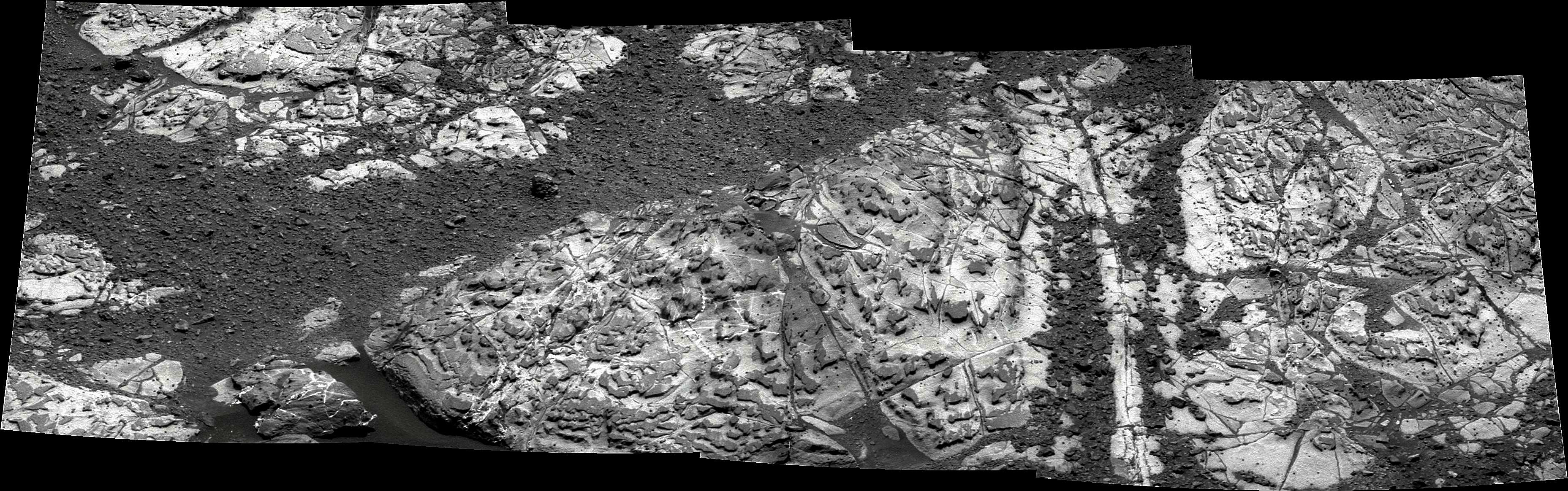
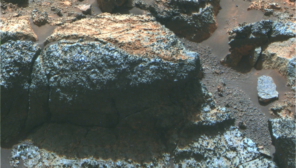
Whitewater rocks all around
This mosaic of several separate images, which Stuart Atkinson processed to bring out textures and shapes on and around the rocks, shows the Whitewater Lake-like rocks that Opportunity now finds all around her. These rocks may be the source of the clay minerals, specifically smectite, that the scientists know from CRISM are hiding somewhere in the area the rover is now exploring. "Although the smectite could be shed down hill in the soil, in the end, I think the Whitewater materials are the areally extensive unit and compositionally the best bet to have this altered phase," said Ray Arvidson, MER deputy principal investigator during an interview with the MER Update.The Matijevic Pan will be more than just a pretty picture. "As we work to figure out the detailed story of the history of this part of Mars - including the continuing search for clay minerals that have been seen from orbital data sets - this panorama will provide critical geologic context for the detailed chemistry and mineralogy interpretations that are made," said Bell.
As November comes to a close and December takes hold, the atmosphere is still dusty from the mid-November storm, but Opportunity is producing nearly 560 watt-hours of power and seems ready, willing, and able to roll wherever her team directs her. And science team members have a number of juicy targets on their list.
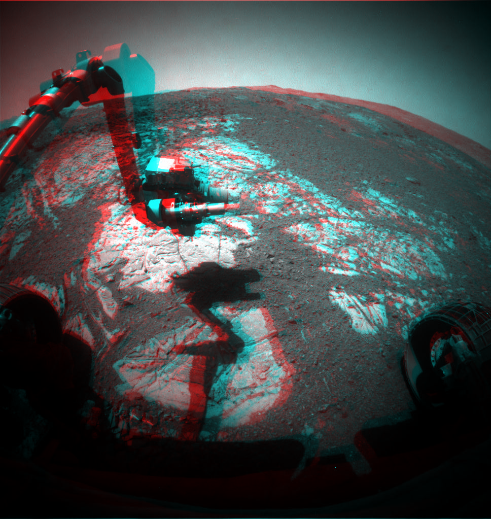
Checking out Sandcherry 3D
Get your 3D glasses on and check out this simulated 3D image of Opportunity hunkering down over Sandcherry, the target on the Whitewater Lake-like rock the rover examined in November 2012.NASA/JPL-Caltech/Cornell/ASU/S. Atkinson
Opportunity will continue work at Sandcherry and the Whitewater Lake-like rock on which the target is located, making a couple more measurements there and tasting the soil around it, until the Matijevic Pan is finished, said Arvidson.
Then the rover will then rove on to a number of other close-by destinations now under discussion among MER science team members. In the last Science Operations Working Group (SOWG) meeting of November, team members discussed having Opportunity make a slight bump - basically a rotation - to bring the IDD workplane over parts of the Whitewater material that has "some white lumpy material on it," said Arvidson. "This stuff isn't a vein, but it could be where the liquid has come up and spread between the bedding planes. Veins go in vertically, but at some points it could come up and the material could fill in between bedding planes so this may be a kind of surface expression of a vein, at the boundary between the two bedding planes."
So Opportunity soon may be taking a close-up look at this bright lumpy material. Following that, Arvidson said, there is "a pretty strong consensus" to go up to a place called Copper Cliff, a couple, three meters to the west where there is a break in slope that's like a little bench you might sit on. "Copper Cliff looks like Kirkwood-like material, and may be a contact between Whitewater Lake and either Kirkwood or Shoemaker or both materials," he said.
NASA/JPL-Clatech/Cornell/ASU/S. Atkinson
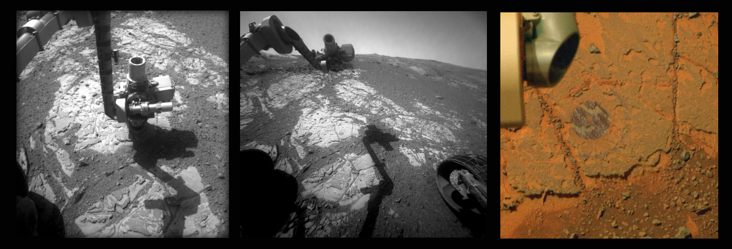
Getting down to business
In this series of images, you can see the "fruit" of Opportunity's labor in November 2012 on a target called Sandcherry, which is on a rock that looks a lot like Whitewater Lake, which the rover checked out upon arriving at Matijevic Hill. The robot field geologist used her RAT to brush and then grind into the target and the weird coating or rind that seems to be splashed on these flat, light-tone rocks. This series comes courtesy of Stuart Atkinson, of UnmannedSpaceFlight.com. DFor more of Atkinson's work, please visit his On the Road to Endeavour blog.Finding and studying a contact or boundary between the Shoemaker Formation and the Kirkwood and Whitewater materials that are exposed would help the MER scientists determine the structure and stratigraphy of Matijevic Hill and likely put them on the path to resolving at least part of the geologic mystery at Endeavour Crater. "The plan as of now is for the rover to bump up to there toward the end of next week and get closer, see what it is, and maybe make some IDD measurements if we see something worthwhile," he said.

A brushed Sandcherry
This composite image, made up of pictures that Opportunity took with her microscopic imager (MI), shows a really close-up view of the freshly brushed Sandcherry, the target on the Whitewater Lake-like rock the rover examined in November 2012. It may – or may not – be the hiding place of the smectite clay minerals for which the rover and her team are hunting. Sandcherry is actually a spot on the rock that is covered with the strange coating or rind.NASA/JPL-Caltech/S.Atkinson
After that, "it depends on what we find," Arvidson said. Also on the wish list, he added, is confirming whether there are more Shoemaker Formation rocks a little bit uphill from Opportunity's current position, looking more closely at the spherules or "newberries," and the veins the rover has been seeing around Matijevic Hill, especially on the Whitewater Lake-like rocks.
"These recently found spherules are not the hematitic concretions of the Burns Formation, but something else, and we're not exactly sure," said Arvidson. "So, we want to find a place where there is lateral variation in the areal density of spherules so we can offset APXS measurements to separate the composition of the matrix from the spherules. The veins are almost certainly due to water coming up through the cracks and filling them with something - maybe gypsum but we don't know yet. We have to find a good, thick one and get the APXS down," he said.
In addition, there's "a lot of good outcrop" where Opportunity started at Kirkwood-Whitewater and to the west of it. "So we may drive north and downhill roughly to get back to the original starting point of Whitewater and Kirkwood to close the rectangular circle of the rover's survey," Arvidson said.
A primary objective of the MER science team members here on Matijevic Hill is to sort out the rock layers, distinguish the Shoemaker Formation breccias from the Kirkwood outcrop with the "newberry" spherules from the bright, flat Whitewater Lake-like rocks with the weird coating. They still don't know which layer is the oldest, the Noachian era crust, and at this juncture there are more questions than answers.
"Where did this Whitewater and Kirkwood stuff come from - is it just stuck under the hill? Or is it part of the bedding column or the stratigraphic column - exactly what are we looking at? How are they bedded? Are they bedded in such a way that it's the normal kind of pancake stratigraphy, with the rocks kind of dipping into the side of the hill, or what exactly is happening?" posited Arvidson.
Newberries in false color
This Pancam mosaic shows part of the Kirkwood outcrop in false color to better distinguish the rock's features. Kirkwood, a wild looking outcrop that sports fins, is what drew the MER science team members, along with the CRISM findings, to Matijevic Hill. This is the outcrop where the rover found the new kind of spherules, or "newberries," as Steve Squyres initially dubbed them. They are not the same as the hematite "blueberries" the rover found previously, and as of yet, the scientists don't know what they are. This photograph was processed by the Pancam team at Cornell and Arizona State University (ASU).NASA/JPL-Caltech/Cornell/ASU
The MER scientists admittedly have a ways to go to answering those questions. The end goal of course is to find out more about what early Mars, Noachian Mars, was really like, based on the hard evidence the rover is uncovering.
"I think what we discover here will tell us about early impact processes that formed the ancient crust and the subsequent role of water in modification," offered Arvidson. But, for the moment, he said, the take-home message: "Life is complicated."
Protect Our Shared Future
You help us defend humanity and prevent asteroid impacts. Donate now to become a Planetary Defender!
Donate