
 Explore Worlds
 Find Life
 Defend Earth


Mars Exploration Rovers Update: Opportunity Ascends Murray Ridge into Clay Mineral Grounds
Sols 3474 - 3502

Written by
A.J.S. Rayl
Contributing Editor, The Planetary Society
December 3, 2013
Mars Exploration Rover
NASA / JPL-Caltech / Maas Digital
Although winter took hold at Endeavour Crater in November, Opportunity pressed on, climbing up Murray Ridge and driving into a clay mineral hunting ground as the Mars Exploration Rovers mission cruised another month closer to celebrating its 10th Earth year of surface operations with myriad events throughout January 2014.
The ridge – which forms the backbone of the Solander Point section of Endeavour Crater's eroded rim – is named for Bruce C. Murray, who founded The Planetary Society with Carl Sagan and Louis Friedman in 1980. Murray, who passed away last August at the age of 81, was one of the first generation of explorers to robotically depart Earth for other planets, and one of the planetary science community's most brilliant minds.
The christening of the ridge was announced November 10th at a standing-room-only memorial for Murray, held at the California Institute of Technology's Athenaeum. After delivering a message from the NASA Administrator, James Green, Director of the Planetary Science Division at the Science Mission Directorate, made the announcement. He then gifted Murray's wife, Suzanne Moss Murray, and family with a framed copy of the panoramic image of Murray Ridge that Opportunity took just before it began its first ascent.
At an elevation about 40 meters (131.23 feet) above the surrounding plain, Murray Ridge is "the highest hill we've ever tried to climb with Opportunity," said Steve Squyres, MER principal investigator, of Cornell University. For those who knew Murray, there's a poignant nuance here, especially considering that the rovers weren't designed to hike hills.
Murray's most visible or famous role was as Director of the Jet Propulsion Laboratory (JPL) from 1976 to 1982, basically from the end of the halcyon days of the Space Age – Viking, Voyager – through the troubled times that followed. "He led JPL during a time when the planetary exploration budget was under pressure and the future for planetary missions was not clear. His leadership brought us through that period with a strong exploration program," Squyres said. And JPL, of course, is where Spirit and Opportunity were designed, built and are being managed.
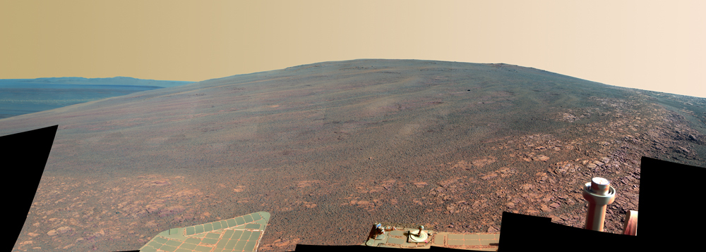
NASA / JPL-Caltech / Cornell / ASU
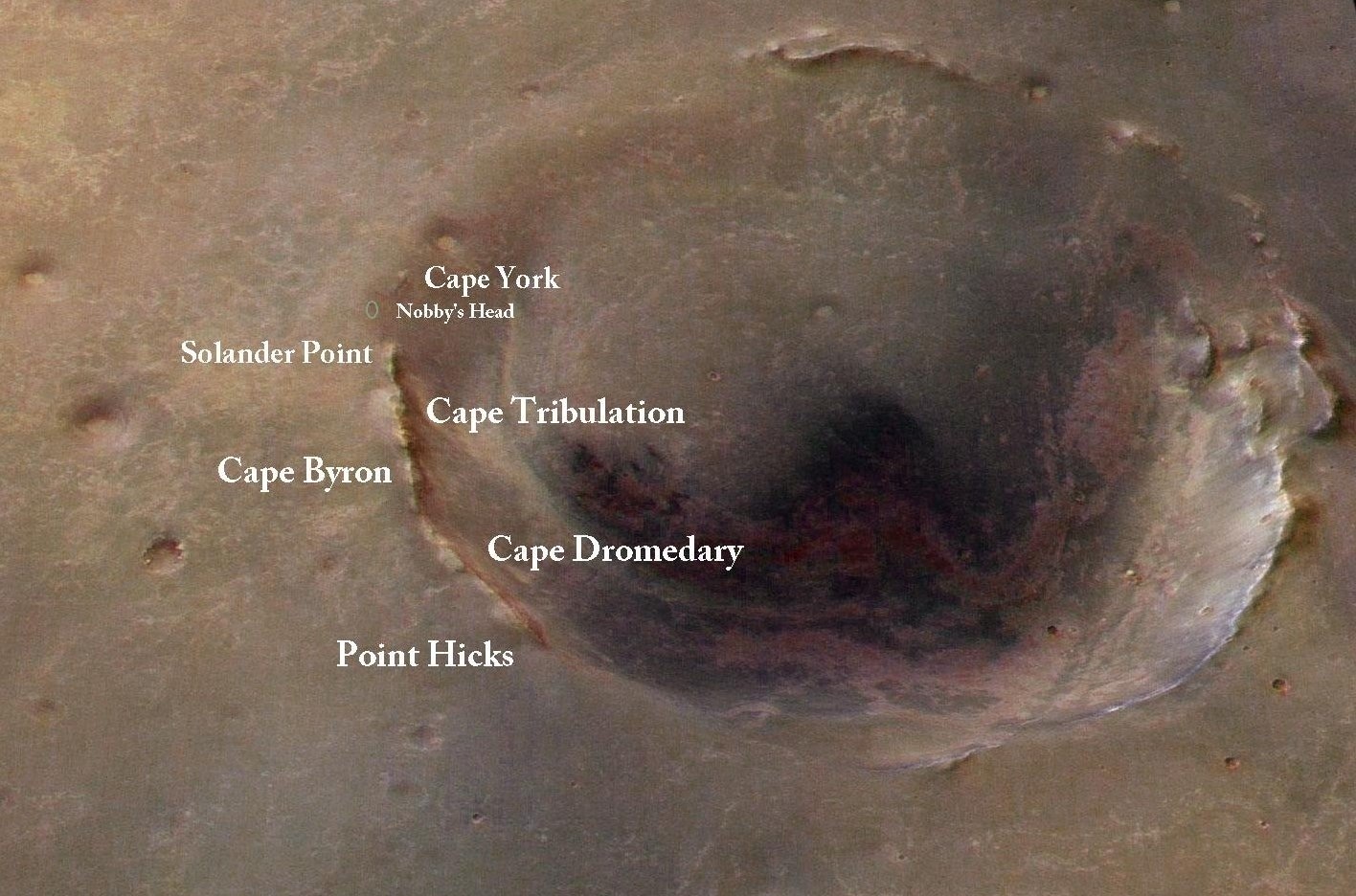
Murray Ridge
Opportunity captured this view of Murray Ridge, in early October, from a position at the base. The component images were taken over the span of five sols or Martian days, beginning on Sol 3446 (Oct. 3, 2013). The ridge, which forms the backbone of Solander Point, is named in tribute to Bruce C. Murray (1931 - 2013), a former director of NASA's Jet Propulsion Laboratory and one of the founders of The Planetary Society. Orbital observations indicate the presence of clay minerals further up this hill, more evidence of ancient flowing water and possible past habitable conditions. For a higher resolution version, visit the Pancam instrument page.
For more than a decade before his appointment as JPL director however, Murray was pushing the planetary exploration envelope and blazing trails. A Caltech planetary geologist, he worked on the science teams of NASA's earliest missions to Mars in the 1960s and '70s and pioneered the fields of planetary imaging and comparative planetology. He inherently understood the value of images, considered by most physicists in the early days to be less science and more public relations gimmick. And Murray, who suffered fools badly, knew well how to stand his ground and he was right a more than he was wrong.
From the first fuzzy black and white photographs taken by Mariner 4 in 1965, Murray was able to work out the geologic history of Mars, and he added to his findings on future Mariner missions to the Red Planet. "He was a towering figure in Mars research," said Squyres. "His papers are still cited abundantly today."
When he retired from JPL in June 1982, Murray returned to teaching and research at Caltech, where he ushered dozens of students into the fields of planetary science and geology, and became more active again in The Planetary Society and its projects.
Through it all, the Admiral of the Solar System, as some people will always affectionately remember Murray, was inspired by Captain James Cook who some 245 years ago began to sail the seas of Earth to ground-truth and chart the lands less traveled or unknown. In a beautiful coincidence, the MER team, years ago, named its metaphorical "ship," Endeavour Crater – which is carrying the mission back in geologic time – after HMS Endeavour, the British Navy research vessel Cook helmed on his first voyage of discovery, setting sail in 1768.
With Spirit's and Opportunity's combined total of more than 465 gigabits of data returned to date – including more than 250,000 thousand images – scientists are for the first time able to ground-truth Martian environments, past and present, and compare them to environments on Earth.
Bruce C. Murray (1931-2013)
Bruce Murray, with Carl Sagan and Louis Friedman, founded The Planetary Society in 1980 to mobilize public support for planetary exploration. One of the first generation of "Space Age" explorers to embark robotically from Earth and explore the other planets in our Solar System, he was "a towering figure in Mars research," said MER Principal Investigator Steve Squyres. Murray's influence on planetary science, as well as on the Society, is immeasurableThe Planetary Society
Perhaps though the most meaningful tribute to Murray is that during the next four to five months, through its sixth Martian winter, Opportunity will write the next chapter in the book of MER on and around his namesake ridge. From orbital data, it already appears that chapter will be scientifically compelling. It may even reveal some of the mission's most important findings and / or may uncover some of the greatest Martian mysteries.
That Murray Ridge chapter effectively began once the veteran robot field geologist hit the slopes of the ridge and started hiking. In November, Opportunity's sites were set on an outcrop dubbed Moreton Island near the top of Murray Ridge. It's "one of the places" where the Compact Reconnaissance Imaging Spectrometer for Mars (CRISM), a visible-infrared spectrometer onboard the Mars Reconnaissance Orbiter (MRO), "suggests the presence of clay minerals," said Ray Arvidson, deputy principal investigator, of Washington University St. Louis.
Arvidson, who is also a co-investigator on the CRISM team, managed to schedule an MRO pass over Murray Ridge a couple months back so that the infrared spectrometer could collect more data. Basically, this data enable Arvidson and the MER team to reduce the pixilated areas where CRISM detected clay mineral signatures from 18 meters to about 5 meters, so they can better zero in on the location of the clay minerals.
Moreton Island lit up that data. "It's the big glowing signature for clay minerals from CRISM in this area, but it's still weak," said Arvidson. Nevertheless, the signature was real and in late October, the MER team decided to direct Opportunity to Moreton Island.
But before Moreton Island, a dust patch, dubbed Yellow Bellied Glider, after the gliding tree possum of Australia, stopped the rover in its tracks. It was a rare pristine-looking dust sample, so the MER team decided to have Opportunity check it out. The rover pulled up to the dust patch on Halloween, and began the month of November looking it over and analyzing its chemical composition with its Alpha Particle X-ray Spectrometer (APXS).
"It's funny, as ubiquitous as dust is on Mars, it's actually surprisingly hard to find a target that is pure dust," Squyres pointed out. In fact, Yellow Bellied Glider is just the third dust sample Opportunity has studied in all of its nine years and 10 months of roving Mars, and the rover devoted most of the first week of November to conducting a thorough examination.
When all was done and assessed, Yellow Bellied Glider came out looking like average Martian dust, but it may be the best sample of dust this rover has ever seen, according to Squyres. "This is not Earth shattering science, but it is an important measurement to make," he said. "Every APXS measurement we've ever made on Mars has been contaminated to some degree with dust. Even when we brush [with the rock abrasion tool (RAT)], even when we RAT – there is dust everywhere on Mars. We can never get rid of it. Dust is always present. So, if we want to understand the APXS measurements we get on virtually everything we look at, then knowing the composition of that dust is an essential thing to have so we can subtract it out of the other data," he explained.
Opportunity spent the second week of November into the third leaving Yellow Bellied Glider and hiking to Moreton Island. "We were boogying the whole time, but boogying slowly. It's wintertime," said Squyres. "The dust [study] cost us a lot of time, because we drove into it from below, and there was so much sand and dust that we couldn't just power on through it up hill. So we had to back down and drive around, and we lost about three sols."
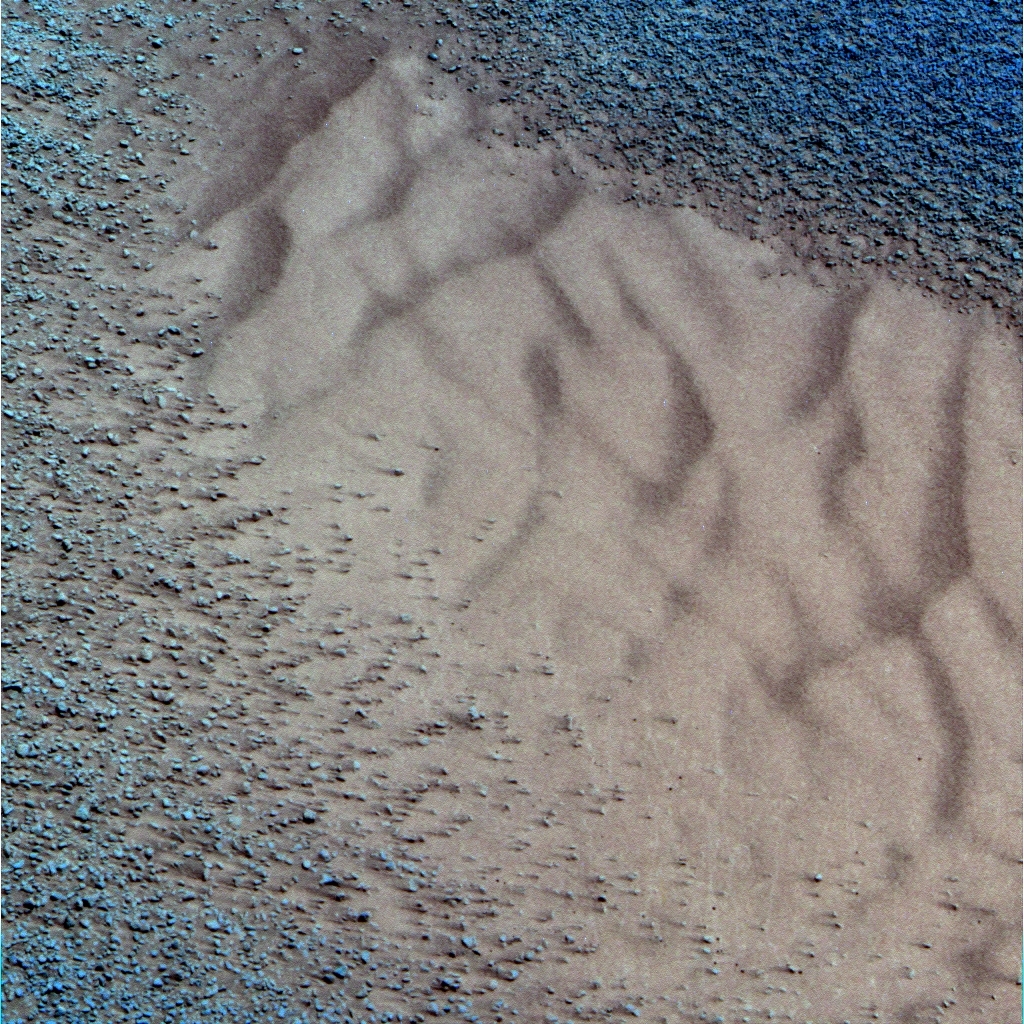
Yellow Bellied Glider
Yellow Bellied Glider is a dust target named after the gliding tree possum of Australia and Opportunity devoted most of the first week of November to checking it out. That's because "[a]s ubiquitous as dust is on Mars, it's actually surprisingly hard to find a target that is pure dust," MER PI Steve Squyres pointed out. In fact, this pristine looking patch is just the third dust target this rover has studied up close in all its years of roving Mars.NASA / JPL-Caltech / Cornell / ASU
Moreton Island appears to have been worth the wait. Named after the third largest sand island in the world, located on the eastern side of Moreton Bay along the coast of southeast Queensland, Australia, Moreton Island on Mars is "a really interesting outcrop, with a whole lot more soft, really bright matrix exposed than anywhere else I've seen in terms of this areal extent," said Arvidson. The matrix, "the really fine stuff," he speculates, could be what is carrying the clay mineral signature.
But the outcrop also has "some very strong, erosionally resistant rock clasts that are embedded in the fine-grained, more erodible matrix," noted Squyres. "There's been a lot of wind erosion, and because of a prevailing wind direction. "The sand blasting that takes place as the wind blows sand across this outcrop has created a kind of grooved or striated appearance to this thing."
Opportunity's work on Moreton Island continued as November came to an end. It looks to be an outcrop of impact breccia, a type of rock fused together and formed from broken fragments of older rocks likely at the time of whatever hit the area and carved out Endeavour Crater. But it's also a little different than the impact breccias the MER team saw at Cape York.
After examining the Moreton matrix, the robot field geologist will check out one of the dark, embedded rock clasts up close, and then move on to other outcrops and locations where CRISM has detected clay minerals. "We'll be driving along the side of the ridge, because to a couple more outcrops of what we think is this matrix-rich breccia," said Arvidson.
The immediate plan at the end of November called for Opportunity to head south from Moreton Island, about 30 meters to another similar looking outcrop that lit the CRISM clay mineral data. From there, it will head further south and east for about 70 meters, just over the top of Murray Ridge, to a place that is temporarily being called the 'winter wonderland,' said Arvidson. "That's probably where we'll try to be in the January to February time frame, through the depths of winter," said Squyres.
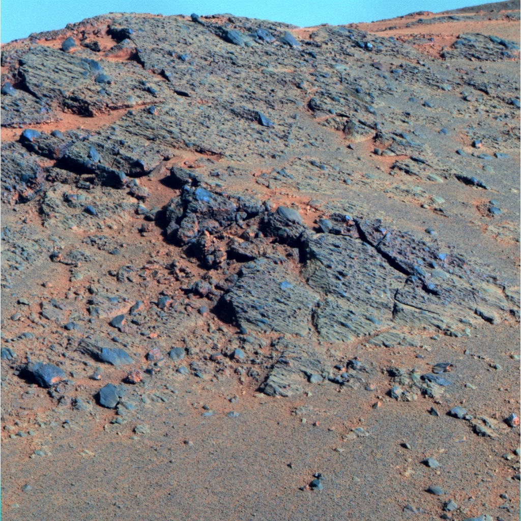
Moreton Island
Opportunity spent the second half of November examining bedrock dubbed Moreton Island up close. It's one of the areas along Murray Ridge where the Compact Reconnaissance Imaging Spectrometer for Mars (CRISM), a visible-infrared spectrometer aboard the Mars Reconnaissance Orbiter (MRO) "suggests the presence of clay minerals," said MER Deputy Principal Investigator Ray Arvidson, also a co-investigator on the CRISM team.NASA / JPL-Caltech / Cornell / ASU
Although the Martian winter in the planet's southern hemisphere has noticeably set in, Opportunity has barely seemed to notice. "This is sounding a like a broken record, but the rover is doing well and there are no new issues," reported John Callas, the MER project manager at JPL.
The solar-powered rover has been successfully driving from one northerly slope to another, what the team calls "lily pads," so it can angle its solar arrays to the Sun in the northern sky and take in as much sunlight fuel as possible. So far, so good.
"We're hopping from lily pad to lily pad and doing fine," said Squyres. At Moreton Island, "Opportunity is positioned at 18 to 19 degrees northward tilt," he said, "and we have our next few lily pads identified."
Spirit effectively used the lily pad strategy as it was hiking Husband Hill. Now that Opportunity is employing the strategy and climbing Murray Ridge, "this winter for Opportunity will probably be like Spirit's first winter at Husband Hill," Ashley Stroupe, MER rover planner, of JPL, said during a recent interview. That means, barring any unforeseen untoward event, the rover will continue to rove, if only to the next lily pad, and work throughout the harsh season.
Moreover, MER team's latest power projections seem to endorse that. "Our numbers were pretty much on model," confirmed Bill Nelson, chief of MER engineering, at JPL. "That means we should be able to do an active campaign throughout winter, which probably includes a little mobility in addition to everything else."
Even though this is Opportunity's sixth Martian winter, it may be the most productive and rewarding winter it's ever had. "The 'winter wonderland' is pretty areally extensive and has a lot of north-facing slopes that will allow us to do some good winter campaign observations and still move if we want," said Arvidson.
By the time Opportunity pulls into its 'winter wonderland,' the MER mission's 10th anniversary of surface operations will be just around the corner. Celebrations, physical and virtual, are being planned throughout the month of January 2014. The Planetary Society is creating special MER 10 virtual features for its website that will, as of now, include an opportunity for people to send their spirited thoughts to the MER team, exclusive video interviews with team members, and trivia quizzes. The Society is also encouraging its members to hold events in cities across the country and around the world.
Meanwhile, the Smithsonian National Air and Space Museum is scheduled to open its MER exhibit January 3, 2014, 10 years after Spirit wowed the world with its bounce down onto Mars. And NASA Headquarters will be acknowledging the mission, the MER Update hears, with an event around the same time, perhaps in coordination with the museum. And, another celebration will be held at JPL in mid-January.
As big of a deal as 10 years roving the surface of Mars is, if you ask the members of the MER team for their thoughts on the 10th anniversary, they stop, or hesitate, searching for words. Some chuckle, seemingly to buy time, but still come up with nothing.
'Amazing,' 'incredible,' 'extraordinary,' 'remarkable,' 'unbelievable' – all those descriptors have been used ad nauseam to describe the MER mission and the rovers throughout the years. It was initially funded as a three-month expedition after all.
What is clear is that the MER team is focused not on the past, but the future. "Yes, we've had a decade of phenomenal exploration, and we still have this very capable vehicle – that's the thing," said Callas. "It's not that Opportunity has lasted so long. It's that there's still stuff to do that we can do. This mission is not over by any stretch of the imagination."
The beauty of Murray Ridge is that there's so much stuff for Opportunity to see and do right there, and plenty of northern slopes where the solar-powered rover can rest and recharge. The 'winter wonderland' area – from the looks of the CRISM data and HiRISE images – appears to be "flat, light-toned rock," Squyres said, similar to the rock outcrop the MER team found on Matijevic Hill earlier this year. "Whether it is, we have no way of knowing until we get there, but there's a good lily pad there and that's good from a power perspective."
What they do know is that Murray Ridge boasts the most extensive stack of rocks and layers that Opportunity has encountered, much of which dates to the Noachian Period some 3 to 4 billion years ago when Mars was warmer and wetter. It almost has to be harboring scientific riches and Martian mysteries as yet unknown, and the team is getting energized, all over again.
"We're really excited about getting to the apparently clay-rich materials that lie out ahead of us," Squyres said. "We're all thinking, 'Whitewater Lake, newberries – ooh, ooh – we get to do that again.' But what we're actually going to see is anybody's guess."
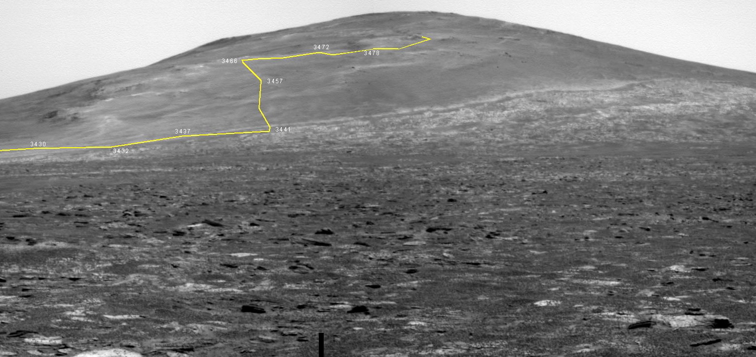
NASA / JPL-Caltech / Cornell / ASU / L. Crumpler
Opportunity's ascent up Murray Ridge
"This graphic that Larry Crumpler put together is awesome," said Steve Squyres, MER PI. "It's a Pancam shot that was back when Opportunity was crossing Botany Bay looking toward Solander Point / Murray Ridge, and Larry plotted our route up hill. It shows how much climbing we've done and it's pretty dang impressive." Opportunity took this image with its Pancam on Sol 3365 on approach to Solander Point and Crumpler plotted the rover's path up Murray Ridge, in yellow. Crumpler is the Research Curator of Volcanology and Space Sciences at the New Mexico Museum of Natural History and Science, and associate professor at the University of New Mexico. He writes an "expert blog" that is also published at The Planetary Society's website. See: http://www.planetary.org/connect/our-experts/profiles/larry-crumpler.htmlOpportunity from Meridiani Planum
Opportunity spent Halloween, its Sol 3473 (October 31, 2013), Mars style, driving 8-meters (26 feet) up to a knock-out dust target in the small ripple field, that was soon being called Yellow-Bellied Glider, keeping with the MER Team's current things-from- Australia naming theme. "We saw it, stopped, and said: 'Whoa, we've got a good dust deposit here, let's take a measurement.' Because it's pretty rare," said Arvidson.
When November dawned at Endeavour, the robot field geologist was positioned over Yellow-Bellied Glider and ready to check it out up close. It appears similar to the two other dust deposits this rover has investigated. The first was Les Houches, named after a ski resort in France, which the rover checked out way back on its Sol 60, when it was still at its landing crater Eagle. And the second, North Pole, wasn't found and chosen for inspection until May 2012, when Opportunity was on the northern side of Cape York by Greeley Haven. "But those both had a little bit of other stuff in them," said Squyres.

Opportunity route map
This route map, produced by Eduardo Tesheiner, of Unmanned Space Flight.com (UMSF.com), shows Opportunity's recent travels. It tracks the rover's route around Solander Point, into its winter site on the western side of this section of Endeavour Crater's eroded rim, and up and south along Murray Ridge. Tesheiner creates his route maps, which are regularly featured in the MER Update, from images taken by the HiRISE camera onboard the Mars Reconnaissance Orbiter and then charts the rover's drives, in yellow, and labels the main waypoints and stops along the way (in red).NASA / JPL / UA / E. Tesheiner
On Sol 3475 (November 2, 2013), the rover used her instrument deployment device (IDD) or robotic arm and took pictures with its Microscopic Imager (MI) to create a larger mosaic of the dust target, and then placed the APXS on the same for a multi-sol integration or analysis. "It really, really came out well," said Squyres.
Opportunity also "pressed" the contact plate of the Mössbauer spectrometer down on Yellow Bellied Glider and it made a telling imprint. "We took MI images of it after the measurement and you could see the screws the Germans had put into place in bas relief. So it was very fine-grained stuff, said Squyres.
There were a couple of indicators Yellow Bellied Glider was the best, most pure dust sample of the three, said Squyres, and it's fine-grained appearance was one of them. "In the MI images, it looks like Talcum powder, incredibly fine-grained, and beautiful, with nothing there but dust. The other indicator is when we look at the APXS measurement it was higher in both sulfur and chlorine than any other attempt we ever made to make a dust measurement, and we know that sulfur and chlorine tend to be concentrated in the dust. So after nearly 10 years, we finally got a really good, clean dust composition measurement," he said.
At the same time, there is nothing particularly important scientifically about Yellow Bellied Glider. "It looks like average Mars, but getting it down to the third decimal place, figuratively speaking, is really important because we need that information to correct all the other APXS measurements," said Squyres. "Because dust is everywhere."
Opportunity wrapped up her inspection of Yellow Bellied Glider on Sol 3477 (November 4, 2013) and took off for Moreton Island the following sol. Getting around the dust ripples around Yellow Bellied Glider took some time. Basically, the rover maneuvered along Murray Ridge, making a dogleg maneuver to avoid driving through the dusty ripple field. At the end of the sol, 3478, the rover had put another 17 meters (56 feet) on its odometer. "We wanted to leave Yellow Bellied Glider carefully, because it was a dust and sand heavy area," said Squyres.
If Opportunity had tried to power straight up hill and through it, there could have been trouble. Although its six weeks in Purgatory Dune, [in truth a ripple, not a dune despite the name], was back in April-May 2005, the memory looms large and still strikes fear into the heart of rover ops folk. In addition to that they noticed "some pretty high wheel slippage" in the rover's final approach to Yellow Bellied Glider. "So, rather than blast on through it, we decided to go around and it cost us a few sols," said Squyres. But erring on the side of caution has been this team's modus operandi, especially since that nasty encounter with Purgatory.
Overview of Endeavour Crater
This image, taken by the University of Arizona's HiRISE camera onboard the Mars Reconnaissance Orbiter, shows the sites where Opportunity has been and is going. It was colorized and labeled by MER poet Stuart Atkinson, of UnmannedSpaceFlight.com, a frequent image contributor to the MER Update. Atkinson has been following Opportunity's path to Endeavour in his blog called The Road to Endeavour, which you can visit here: http://roadtoendeavour.wordpress.com/NASA / JPL-Caltech / UA / S. Atkinson
From the oversampled along track data that Arvidson had acquired from CRISM and then processed for the rover's current hunt for clay minerals, Moreton Island looked to be the best clay mineral spot in the immediate area. Commanding Opportunity to drive there was a no-brainer.
It took a while. The rover devoted the last of the first week, the entire second week, and several days into the third week of November hiking to Moreton Island. "Recognize we're making fairly slow progress these days, because it's winter and the power is so low," said Squyres.
By mid-November, Opportunity was really beginning to feel the winter. On her Sol 3489 (November 16, 2013), the scheduled drive had to be shortened considerably because of the constraint of the expected state of charge of the rover battery. So, as it turned out, the rover only turned to face Moreton Island and bump 10 centimeters (4 inches). But she did take some pictures of Moreton Island with her Panoramic Camera (Pancam) and Navigation Camera (Navcam).
From that distance, it looked something like Chester Lake, a rock Opportunity found and inspected back at Cape York. But, it was different too. In particular Moreton Island seemed to have large, dark rock clasts embedded in it.
On Sol 3492 (November 19, 2013), the rover bumped forward, logging just about 3.5 meters (11.48 feet) to approach the outcrop and then settled in for an in-depth study with the four science instruments that are still working and her camera. The rover's mineral detectors – the Miniature Thermal Emission Spectrometer (Mini-TES) and the Mössbauer Spectrometer – are no longer functioning.
As the third week of the month turned to the fourth, Opportunity took more close-up pictures with her MI, and then took APXS measurements to glean the chemical composition of a spot on Morton Island's light-toned matrix. "From a distance it looked like it might be finely layered, but when we got up close we realized it's not layering at all," said Squyres. "What we're seeing are the consequences of wind erosion of very heterogeneous rock."

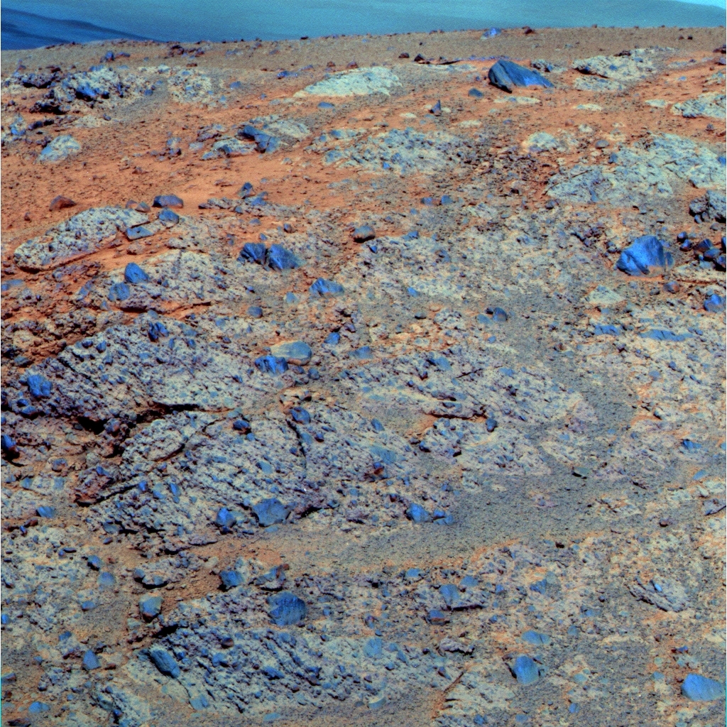
Yellow Bellied Glider up close
In examining Yellow Bellied Glider, Opportunity pressed the contact plate of the Mössbauer spectrometer, built and managed from Germany, down on the target. It made a telling imprint. "You could see the screws the Germans had put into place in bas relief in the MI" [picture taken with the microscopic imager], said Squyres. "So you can see it's very fine-grained stuff."NASA / JPL-Caltech
From the data they've been able to look at so far, Moreton Island does look similar to Cape York's flat bedrock breccia, known as Chester Lake. "We ground into it with the RAT and found it featured very fine-grained matrix, and we thought it was the glassy part of what was emplaced," said Arvidson. "I think the outcrop we're on, Moreton Island, is similar, but it's huge. It's big enough so you can actually pick it out of the few pixels of CRISM data. We drove there because we thought it would be unique because of the spectral signature – and lo and behold – geologically, it's a really large exposure of matrix with a few, large dark clasts we've never seen before to this areal extent."
While the first APXS results had just arrived as team members were preparing for the four-day Thanksgiving holiday, Squyres wasn't ready to talk about Moreton Island's chemical composition. "I will say this is definitely breccia, a wind eroded impact ejecta," he said.
Through coordinated orbital and surface observations, Opportunity is already sending home little Martian surprises from Murray Ridge – and winter in the Mars' southern hemisphere has only just begun. The best news is that the rover was able to produce about one-third its power production capability, around 300 watt-hours of power, throughout the month.
The sky remains dusty, and the Tau fluctuated from 0.536 to 0.668 and back to .603. The rover's solar array dust factor also fluctuated from 0.491 at the beginning of November to 0.498 around mid-month and and .500 at month's end. "The dust factor does fluctuate and bounced around a little bit this past month," said Callas. "It's affected by Tau and they have to do calibration periodically so it's not unusual."
For now, Opportunity is remarkably healthy for an old girl, and seems every bit as willing and able to rove on as she always has. "We're not in the lowest part of winter yet, but we're getting darn close and we're doing well," said Squyres.
When the calendar turns to December, Opportunity and her team will be ready to rove again. "We've been at Moreton Island for a while," said Squyres. "We've been working it over and we've already got good MI coverage and good APXS. We planned more MI and more APXS [over the Thanksgiving weekend] and, unless we find some surprises, I think we'll be ready to leave pretty soon."
Large clasts of Moreton Island
The Pancam team produces false color images to better show the different materials and rocks in the pictures and the distinctive large, dark rock clasts embedded in the Moreton Island outcrop really pop in this one. Moreton Island is where CRISM indicated there were clay minerals, but it is yet to be determined if that evidence will be found in the lighter matrix or in the dark rock clasts.NASA / JPL-Caltech / Cornell / ASU
Soon could come in the first part of the first week of December. The plan is to "button up and drive to another CRISM / clay mineral outcrop to the south, which we believe is like Moreton Island, and check it out," said Arvidson. "Then over the next couple of weeks, we'll continue south and then turn left, or inboard, to what we're temporarily calling the 'winter wonderland," which is a big exposure of very bright outcrop."
Opportunity can see this 'winter wonderland' off in the distance now. "We can see it over the top of [Moreton Island] to the southeast about 100 meters away," said Arvidson. But it's too far to see tell with any certainty if it's more of the Matijevic Formation or more of this very fine-grained, easily-weathered, matrix material that is part of the breccia of Moreton Island.
The drive to it will take Opportunity just over the top of the Murray Ridge and onto the crater side. "But there are still a lot of good north-facing slopes there," said Arvidson.
As of now, the rover is slated to spend the worst of winter there in the 'winter wonderland,' searching for more clay minerals and whatever else may be around for the finding. "This is going to be a much more productive winter than last winter was," said Squyres. "Greeley Haven was a single lily pad surrounded by a whole lot of flat – and there was just no place to go. We went there for good reasons, but we wound up sort of trapped there for winter. And this year, at Murray Ridge, there are so many lily pads and so much to work with, we think we're going to be pretty productive," he said.
"If you look at our maps these days, the next area we're going to try and get to, this light-toned stuff [at the 'winter wonderland'], says, 'Matijevic Formation' with a big question mark," said Squyres. "What it's really going to be when we get there – I don't know. We've got the CRISM stuff guiding us and we'll get there and see what we see."
Please visit The Bruce Murray Space Image Library: http://www.planetary.org/multimedia/space-images/
Protect Our Shared Future
You help us defend humanity and prevent asteroid impacts. Donate now to become a Planetary Defender!
Donate