
 Explore Worlds
 Find Life
 Defend Earth


Mars Exploration Rovers Special Update: Opportunity's Findings at Endeavour, So Far

Written by
A.J.S. Rayl
Contributing Editor, The Planetary Society
May 25, 2013
Mars Exploration Rover
NASA / JPL-Caltech / Maas Digital
After sending home evidence from Matijevic Hill for an ancient Martian environment unlike any it had ever seen, Mars Exploration Rover Opportunity left Cape York May 14th and embarked on a 2-kilometer journey south along the western rim of Endeavour Crater. The robot field geologist is heading now to Solander Point, where it will spend the coming Martian winter.
The trek had barely gotten underway when, during its second drive, the veteran Mars (MER) broke the Apollo 17 rover distance record of 35.744 kilometers by 16.13 meters, becoming the second farthest traveling, manmade vehicle on another planet. Opportunity is now just 1.240 kilometers away from taking the "gold" in rover distance from the Russian rover Lunokhod 2. More than nine years into a mission originally planned to last 90-days, it is a testament to American engineering and the MER rover operations team.
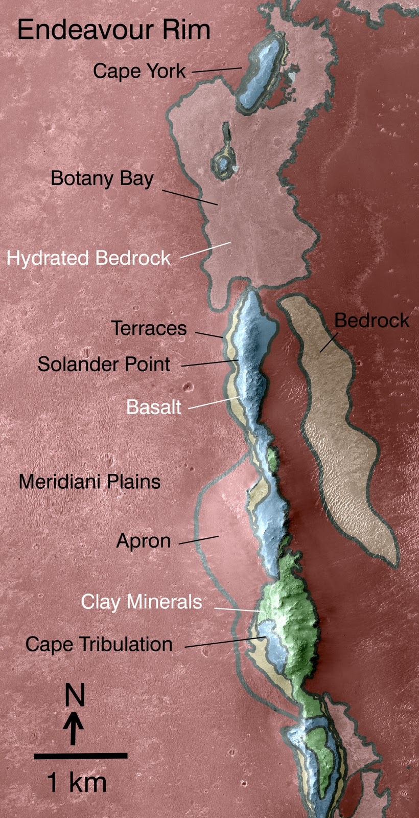
Endeavour Crater's western rim
This is a geologic map of a portion of Endeavour Crater's western rim. It is based on the data taken by a visible-infrared spectrometer on-board the Mars Reconnaissance Orbiter. A discontinuous ridge that runs north-south shows exposed basalt (marked in blue) and clay minerals (marked in green). These geologic formations are believed to be from a time in Martian history before the deposition of sulfates on the portions of the Meridiani Plains region that Opportunity saw during its first seven years.NASA / JPL-Caltech / JHUAPL
As Opportunity and her engineers push the limits of rover longevity, the MER science team members have been pushing the limits of how to explore another planet with an aging rover and get the absolute most out of what they have. It's why this team has become a legend in its own time. And it's paid off big time.
Despite an arthritic shoulder, stiff front wheel, a broken heater that has made it completely shut down every night, and the loss of its two mineral-detecting instruments, Opportunity and the MER science team have been conducting groundbreaking research, digging up compelling evidence for a more Earth-like ancient Mars, and making some of the most important discoveries of the entire mission. That science is the focus of this MER Special Update.
For the last 10 Earth months, the robot field geologist has been on an excursion, traveling back in geologic time on Matijevic Hill, located along the inboard side of the Cape York segment of Endeavour's rim. It's roved through and around different geologic times, and ground and scraped into layers of bedrock eons old on. It's found mystery "newberries," and veins, large and small, running through bedrock and ancient soft rocks, the residual signs of clay minerals-together solid evidence that once, long, long ago, lots of flowing water, kind of like water on Earth, created a habitat there suitable for the emergence of life as we know it. It's just the science so many Earthlings have longed to hear about Mars.
The evidence was on tap at the 44th annual Lunar and Planetary Science Conference (LPSC) held in The Woodlands, Texas in March. MER Project Scientist Matt Golombek, of the Jet Propulsion Laboratory (JPL), and previously Mars Pathfinder project scientist, chaired the MER session. Seven scientists talked about Opportunity's findings so far at Endeavour Crater and after the presentations the MER Update talked with the scientists.
Summaries of the work - which represents the first chapter of the book on Endeavour Crater - and the post-conference interviews are offered here following a brief recap of Opportunity's arrival at the big crater. They are sequenced in order of the scientist's appearance at LPSC.
The Endeavour dream
Once little more than a "dream" of a destination, Endeavour is a 22-kilometer (14-mile) diameter crater mostly filled in with sands and sedimentary deposits. Its broken rim rises nearly 100 meters above the surrounding plains in some places, providing hills and ancient rocks for a visiting rover to explore. It's as old a crater as Opportunity has seen, believed to date back to the Noachian Period, a time on Mars some 3.6 to 4.2 billion years ago characterized by high rates of meteorite and asteroid impacts and the possible presence of abundant surface water.
The chance to study Mars' Noachian Period had long been something of a Holy Grail mission for planetary geologists, because the old highlands rocks are where geologists knew they could find evidence for water when the rocks formed. But choice highland areas as seen from orbit are too dangerous to land a spacecraft. So, as Opportunity was finishing up work at Victoria Crater in 2008, the science team confronted another opportunity.
Not only were there known Noachian hills in the distance at Endeavour, but an instrument onboard the Mars Reconnaissance Orbiter had just found the signature for phyllosilicates, specifically a clay mineral known as smectite, harbored here and there in Endeavour's western rim. It was a big deal.
NASA / JPL-Caltech / Cornell / Arizona State University
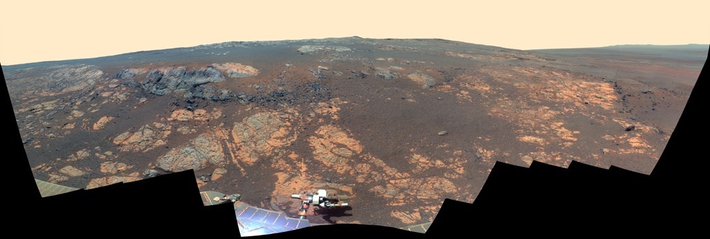
Matijevic Hill Panorama
Opportunity took the hundreds of component images for this picture with her stereo panoramic camera (Pancam) from Nov. 19, 2012 through Dec. 3, 2012. Named in honor of JPL's Jake Matijevic, a Mars rover pioneer and one of the creators of Spirit and Opportunity, the hill is an area in the Cape York segment of Endeavour Crater's western rim. Jake passed away on Aug. 20, 2012, shortly after Curiosity landed. The rover and her team did Jake justice, uncovering signs for an ancient environment where water flowed and where life, theoretically, could have begun to emerge.While there are phyllosilicates that can form in acidic waters, clays typically form in environments with more neutral to alkaline water. Moreover, ground-truthing phyllosilicates is on Curiosity's list of science objectives, not Spirit's or Opportunity's, whose task was to find evidence of past water of any kind. To ground-truth the orbital discovery would be quite a feather in the MER's mast. But Endeavour was 15 kilometers away as the Martian crow might fly.
In September 2008, with the rover's work completed at Victoria Crater, MER Principal Investigator Steve Squyres, of Cornell University, announced the team's bold decision: Opportunity was "heading for the hills."
On August 9th, 2011, after nearly three years and 19 kilometers of roving from Victoria Crater across the tedious Meridiani Plains, Opportunity pulled into Endeavour's rim at Spirit Point. The robot field geologist crossed a geologic boundary from the plains to the crater rim there. "It's like the whole mission started over again," said Squyres.
Hydrated Minerals on Endeavour Crater's rim, Interior, and Surrounding Plains:
New Insights from CRISM Data
Presenter: Eldar Noe Dobrea, Planetary Science Institute (PSI) Tucson
Researchers: Eldar Noe Dobrea; James J. Wray, Georgia Institute of Technology; Fred J. Calef III, Timothy J. Parker, Jet Propulsion Laboratory (JPL), California Institute of Technology (Caltech); and Scott L. Murchie, Johns Hopkins University Applied Physics Laboratory (JHU-APL)
In 2008, the Compact Reconnaissance Imaging Spectrometer for Mars (CRISM), a visible-infrared spectrometer onboard Mars Reconnaissance Orbiter searching for mineralogic indications of past and present water on Mars, recorded the spectral signature for phyllosilicates in the rim around Endeavour, specifically clay minerals in the form of smecitite. The research was published in Geophysical Research Letters in November 4, 2009. It was an important discovery because phyllosilicates form in non-acidic water, water more conducive to the emergence of life, as opposed to the highly acidic water for which both Spirit and Opportunity had already found plenty of evidence.
Eldar Noe Dobrea
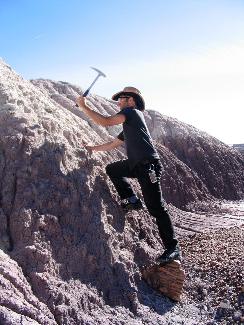
Eldar Noe Dobrea is a Research Scientist at the Planetary Science Institute, Tucson. He is pictured here sampling ancient fluvially deposited clays in the Painted Desert on Earth in an effort to understand the preservation of organics in clay-bearing sediments. Here, he is excavating into the clay to collect a sample that he will test for organics, while using a petrified log as his footstool.Fred Calleff
"When we first discovered the phyllosilicate signature for clays on the rim of Endeavor using CRISM, we recognized that there was more variability and there were more interesting things to look at in the data," recalled Noe Dobrea, during a post-conference interview. So, he and the other researchers went back for a second look in 2011.
Using the original CRISM data along with newer data, they remapped the phyllosilicate signature at Endeavour and Meridiani Planum and found that "the spatial distribution and spectral character of both the sulfates and the phyllosilicates in the area is more diverse than has been reported to date," as they wrote in a paper published in Geophysical Research Letters, last December. In fact, "one of the more provocative results" was their discovery of phyllosilicate signatures in the Meridiani plains, "either as part of the bedrock or the dark mantling sands." Moreover, they appeared to be the very same iron-magnesium smectites that CRISM initially detected in the crater rim. "It was a surprise," recalled Noe Dobrea.
Opportunity spent years driving over those plains and there was never any real talk, not publicly anyway, of phyllosilicates being there. Then again, the MERs weren't charged with finding phyllosilicates and the instruments onboard Spirit and Opportunity were not designed specifically to identify these waterborne minerals. Still, there had been hints.
Several other authors in the past - primarily Tim Glotch and others [Journal of Geophysical Research: Planets, 2006] and Deanne Rogers and Oded Aharonson [Journal of Geophysical Research: Planets, 2008] analyzed the mineral detecting data of the Miniature Thermal Emission Spectrometer (Mini-TES), and suggested that the bedrock or dark sands in the Meridiani Plains may contain a phyllosilicate component.
"In order to best fit the data, by mixing the spectra of minerals from a spectral library, it was necessary to add clays to the mix," Noe Dobrea remembered. "The amount was small, and the degree of uncertainty was large, particularly since it was largely model-dependent. So there was nothing conclusive," he said. At the same time, there had been a lot of evidence for and talk of past water at Meridiani Planum being highly acidic.
Even though the CRISM finding leaves "no uncertainty, because the absorption bands in the near infrared are clear and well-defined," the first thing Noe Dobrea did was go back to the reanalysis data and look at it again from different angles. No matter how he looked at it, he found phyllosilicates, "over and over."

Eldar's science photo
The clay bearing mantling unit defined by Noe Dobrea and others is shown here. The top image is a parameter map, showing what the scientists saw in the CRISM data. The clays are depicted in green, sulfates in purple. The same clay-bearing unit is shown below in a normal orbital image. You can see that the clays tend to associate with the dark mantling material.NASA / JPL-Caltech / Johns Hopkins University Applied Physics Lab / University of Arizona
At Endeavour, Noe Dobrea and the other researchers saw similar phyllosilicate spectra in crater's interior. But there was an "intriguing" difference between the spectra from the interior from the rim - "their absorption bands are not as sharp as those on the rim," said Noe Dobrea. In other words they're weaker. And that suggests "that either these phyllosilicates experienced some type of alteration that affected their structure, or they are mixed with some other phase or phases in Mars' geologic history," the scientists wrote in their Geophysical Research Letters paper published December 8, 2012.
"Usually when we study Mars, we typically find phyllosilicates in rocks that stratigraphically underlie the sulfates, which is an indicator that they are older," Noe Dobrea pointed out. "In this case, the phyllosilicates seem to be a part of the sand sheet that overlies the sulfates." That indicates "some kind of alteration process has been pervasive throughout Martian history and is still occurring" and "that these phyllosilicates were transported into the crater and onto a sulfate mound inside Endeavor after the alteration process happened," he proffered.
Phyllosilicates tend to break down into very small particles that can become suspended in the atmosphere, Noe Dobrea explained, "and when they deposit, they mantle everything under them." In Endeavour's interior, they found that the phyllosilicate clay minerals are associated to a specific geologic unit made of sand-sized particles, suggesting that have been transported as part of the sand sheet. "The dark sands move and the phyllosilicates on them also move," he said. The only way for that to happen is if there had been some alteration of what is thought to be basaltic sand." Meaning, the rocks and mounds in the interior that sport the clay minerals are not completely clay and the minerals have been seriously degraded over unknown millennia.
Oddly, despite the presence of smectite in outcrops on the rim, they found that the optical surface of the rim of Endeavour Crater, contains the most anhydrous terrain in the scene. "When we look at this in imaging data, we realize that the anhydrous stuff is associated to mantling 'soils,'" said Noe Dobrea, the type of terrain rovers and landers have typically found on the surface of Mars.
"It's a different world here," Noe Dobrea said of Endeavour Crater. "We're seeing differences in rock morphology, textures, colors. There's a lot of stuff going on. It's like living at Disneyland!"
Although there is much more to be done before the scientists can understand how it all fits together, in the big picture this research already bolsters the notion that long, long ago, life could have found a way to emerge on the Red Planet.
"We're showing that it's not going to be as difficult as we once believed to find places on Mars where life might have existed," Noe Dobrea said. "It's possible that there are a lot more places on Mars where conditions were good for a long period of time and subsequent acidic conditions may not have been as pervasive or as bad as we might have thought."
Overview of Opportunity Rover Results from Clay-Bearing Materials at Endeavour Crater
Presenter: Steve Squyres, Cornell University
Researchers: Steve Squyres; Ray Arvidson, Washington University St. Louis (WUSTL); and the MER Athena Science Team
As Opportunity was driving south along the inboard side of the Cape York segment of the rim of Endeavour Crater late last August, an intriguing outcrop caught the eyes of science team members. The rover had been taking pictures and the scientists had been looking for something really interesting to investigate. When the odd, richly layered, fin-bearing outcrop (soon dubbed Kirkwood) jumped out in the rover's pictures, they found it. Plus, the outcrop and surrounding area is where the Compact Reconnaissance Imaging Spectrometer for Mars (CRISM), onboard the Mars Reconnaissance Orbiter, detected the signature for smectite, clay minerals.
Steve Squyres at LPSC 2013
Steve Squyres is the Goldwin Smith Professor of Astronomy at Cornell University and the MER Principal Investigator. He is a co-investigator on Mars Odyssey, Mars Express, Mars Reconnaissance Orbiter, Cassini, and Mars Science Lavoratory/Curisity and serves as Chairman of the NASA Advisory Council.A.J.S. Rayl
"The most spectacular layering we've seen yet is right in the heart of the strong orbital clay signature," said Squyres. Opportunity was staring at what Ray Arvidson, MER deputy principal investigator and also a CRISM co-investigator, mapped as the "sweet spot" for the orbital signature. So the science team had their rover "slam on the brakes and take a hard right turn," as Squyres put it. Mars did not disappoint.
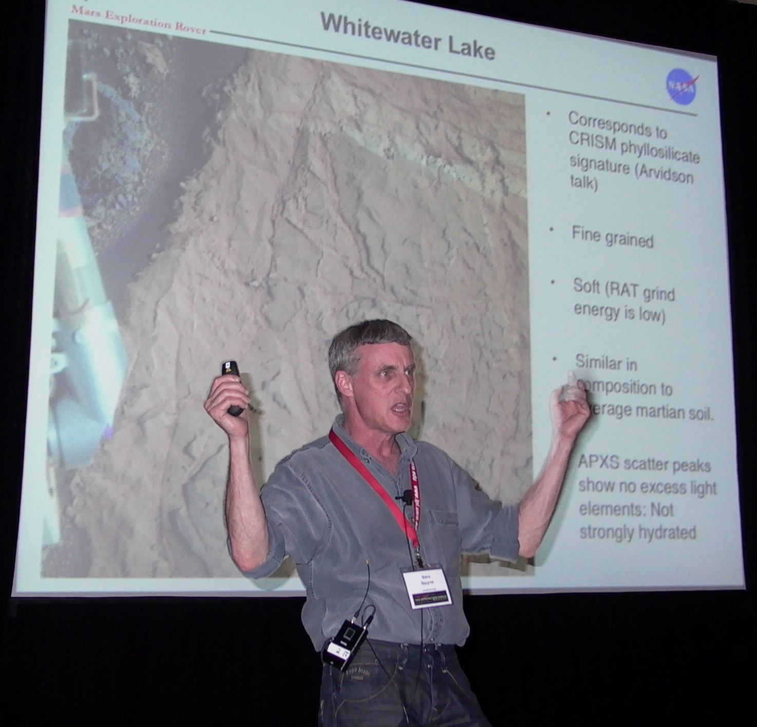
The alluring Kirkwood was at the base of a rise that would soon be named Matijevic Hill, in honor of JPL Mars rover pioneer Jake Matijevic. Immediately, they saw countless tiny spherules, and rich layers of breccia bedrock. And just uphill behind the outcrop, they saw a bright, flat rock, dubbed Whitewater Lake, which was, even as Mars rocks go, weird. "It is the rock that corresponds to the CRISM phyllosilicate signature and Ray will convince you of that later," Squyres said at the conference, foreshadowing what was to come.
"A dominant rock type, the one deepest down in the stratigraphic section we've seen, Whitewater Lake is the oldest rock we've ever looked at," Squyres said. Very fine-grained, it is "one of the softest rocks" they've seen and appears similar in composition to average Martian soil. "There's nothing that makes your eyes pop out about the composition of this rock in terms of elemental chemistry," he said. Visually however, it looked different.
Although it is not a heavily hydrated material, Whitewater Lake sports a strange coating in places is "shot through" with tiny light-toned veins and "lots of little spherules" are embedded within its layers, telling signs of past flowing water. Elemental chemistry data that Opportunity collected with the Alpha Particle X-ray Spectrometer (APXS) on the veins, on a spot on Whitewater Lake called Ortiz, enabled the MER scientists to conclude they are calcium sulfate, as Squyres pointed out, which supported the water notion. The main sources of calcium sulfate on Earth are naturally occurring gypsum and anhydrite, both of which can form in non-acidic or neutral water. [See MER Update, January 2013 issue/Sols 3178-3208]
Rockin' the water story
A rock strata like no other. The pale rock in the upper center of this image, about the size of a human forearm, includes the target in this Whitewater Lake outcrop called Esperance. Opportunity studied the target with its alpha particle X-ray spectrometer (APXS) and fromt he data it sent home scientists were able to determine that Esperance's composition is higher in aluminum and silica, and lower in calcium and iron, than other rocks the rover has examined in more than nine years on Mars. Preliminary interpretation points to clay mineral content due to intensive alteration by water. The view is presented in false color to make differences between materials easier to see.NASA / JPL-Caltech / Cornell / ASU
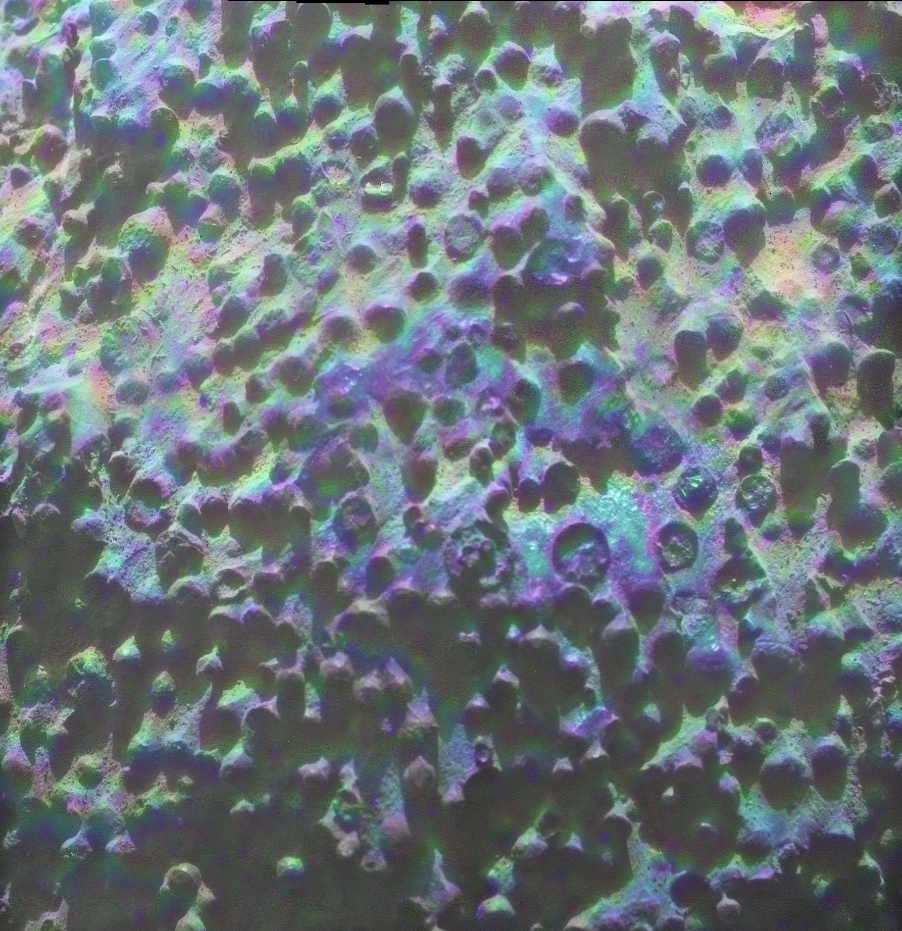
The spherules were a little harder to crack. For the most part, they are highly dispersed through the fine primary bedding of the Whitewater Lake outcrops, said Squyres. "When exposed in cross-section, the rock tends to be finely laminated, with spherules dispersed through and across the lamination. But there are places where locally there are incredible concentrations - this looks like blueberry pie," he said at the conference pointing to what has become one of the mission's favorite images.
Although at first blush, these small spherules look like the hematite-rich concretions dubbed "blueberries" that Opportunity found throughout her travels in the Meridiani plains, there are visual differences and "a big compositional difference," said Squyres. "These do not have the very high iron content that would be required to be the nearly pure hematite blueberries we have seen out on the plains."
The newberries do show concentric structure, with a hard outer shell and a softer middle, and are matrix supported. Contrary to earlier findings, the composition of these spherules "is different from the matrix," Squryes announced at LPSC, acknowledging work of Brad Jolliff. All the newberry data Opportunity returned home led the scientists to conclude they probably are diagenetic concretions, as are the blueberries out on the plains, but "more weakly cemented, perhaps with an iron oxide," he said. "But we're still working on that."
The search for a boundary, what geologists call a contact, between the Shoemaker Formation breccias at the top of Matijevic Hill and the Whitewater Lake unit found lower on the hill led the scientists to conclude there was "a gradational contact," Squyres said. While they thought they saw an abrupt transition from Whitewater Lake to darker rocks and breccias, as soon as Opportunity returned some Microscopic Imager (MI) pictures, they saw spherules and veins in the breccia outcrops. And, as the rover worked her way uphill and up section, the scientists saw - at the highest breccia outcrop on Matijevic Hill - one "one spherule, one berry in the whole thing," he said.
The breccias above the Whitewater Lake unit, which are from the Endeavour impact contain spherules that probably were "liberated" from Whitewater Lake, "the oldest rocks yet explored by the Opportunity rover," Squyres theorized. "This is an incredibly violent event. It rips up this soft crumbly rock and berries get mixed into the breccias above."
The Whitewater Lake rocks are hugely important because they record an epoch before the Endeavour impact, where there was near neutral pH water flowing or melting or pooling, Squyres said, interpreting the data. These bright flat rocks represent "the most habitable paleoenvironment found to date at Meridiani," Squyres et al., concluded in the session abstract. "We're looking into a period in Martian history very early where the conditions were really rather different from what appears to have been the case through most of the planet's history," he elaborated later.
Since Opportunity's two mineral detectors - the Miniature Thermal Emission Spectrometer (Mini-TES) and the iron-detecting Mössbauer spectrometer - are no longer functioning, the robot field geologist cannot directly identify the smectite clays or locate them within the Whitewater Lake outcrops. "The clays could be in the rock. They could be in the coatings. Or they could be in both," said Squyres. "The origin of Whitewater Lake remains uncertain. If this stuff is impact ejecta, it is a very distal ejecta deposit from an older, different crater that predates Endeavour. "
On the other side of Mars, at the same time, the Mars Science Laboratory's Curiosity is sending home images from Glenelg/Yellowknife Bay in Gale Crater that show what appear to be the same spherules and veins and fine-grained rocks. "The rocks we're finding with Opportunity are dramatically different from anything we've ever seen, but astonishingly similar to what we're seeing at the Gale Crater site. Mars is telling us something here," Squyres said in closing his talk at LPSC. "I'm not quite sure what it is, because it's speaking Martian, but it's telling us something."
As the LPSC came to an end and the scientists headed back to work, Opportunity was preparing to hunker down for much of April during the biannual solar conjunction to study the elemental chemistry of boxwork structure of veins at a Whitewater Lake outcrop target dubbed Esperance. And the hits, as the rock'n'roll adage goes, just kept on coming.
In May, NASA/JPL announced that the composition of Esperance, and Whitewater Lake is unlike any other has investigated during nine years on Mars - higher in aluminum and silica, lower in calcium and iron, findings consistent with the presence of past clays and flowing water.
"There appears to have been extensive, but weak, alteration of Whitewater Lake, but intense alteration of Esperance along fractures that provided conduits for fluid flow," Squyres said. "Water that moved through fractures during this rock's history would have provided more favorable conditions for biology than any other wet environment recorded in rocks Opportunity has seen."
Field Geologic Context of Opportunity Traverse
from Greeley Haven to the Base of Matijevic Hill
Presenter: Larry Crumpler, New Mexico Museum of Natural History & Science
Researchers: Larry Crumpler and the MER Athena Science Team
Planetary scientists have been geologically mapping Mars for decades. With photo-geologic maps, essentially visual overviews based on orbital imagery that show the presence of highlands, volcanoes, valleys, and channels cutting through the surface, they have determined the fundamental, critical periods in Mars history. Opportunity and the MER mission are taking the geologic mapping of Mars to the next level - the field, just like geologists do on Earth.
Larry Crumpler
Larry Crumpler, of the New Mexico Museum of Natural History & Science, is a member of the original MER Athena science team and the mission's "resident geology mapper." At LPSC, he presented the first geologic map on Mars created with the kind of ground-truthing that geologist do on Earth. He is Research Curator for Volcanology & Space Science at the museum in New Mexico.A.J.S. Rayl
"The bottom line is we have actually had a chance to investigate the geology of a complex site on Mars with in situ observations, doing fundamentally what we call here on Earth, field geology along the transect," said Larry Crumpler, MER's resident mapper. "We look at the air [orbital] photos first, then we hit the ground to look at outcrops [from the rover's perspective] and we can actually reach out and touch the rocks and look at them and determine what they are. We are doing field geology on Mars."
Actually, with the exception of what the Apollo astronauts did on the Moon several decades ago, Crumpler, Opportunity and her team of scientists have successfully conducted the first field geologic mapping of another planet - and they have found signs of past flowing water. From the basaltic breccias at Greeley Haven, which led the team to conclude the Shoemaker Formation is an impactite from Endeavour Crater, to the segmented gypsum vein Monte Cristo, to Whim Creek, and the outcrops on Matijevic Hill where CRISM detected phyllosilicates, Crumpler recounted Opportunity's trek during the conference, pointing out the rover's significant geologic findings along the way.
For the first time, a rover has traveled far enough on Mars to see different things and to return the data needed to produce these geologic maps. "Opportunity is able to look at and see things fairly well, out to about 20 meters. And through correlation and interpolation between those outcrops where it has actually looked at the rocks, we can [place] the different rock types in an overhead map," Crumpler explained.
A geologic map summarizes all sorts of things. "But mostly it tells the relative ages of different rocks or stratigraphy, the distribution of different types of rock or lithologies, the current attitude or structure, that is, anything that has happened to tilt or distort the rocks since they were formed, and where geologists might predict that similar or different rocks occur," Crumpler pointed out. "This means that a field geologist is literally doing non-stop proposal of hypotheses and in the next step testing them, all day long. In reality, it is one of the most scientific of the sciences," he added. "During the course of mapping, the scientific method is repeated hundreds to thousands of times in a single traverse."
As the rover repeats the process from site to site, it maps out a swath across the terrain. "We end up with a traverse that has things mapped along it. On Earth, we call that a transect," said Crumpler. "It's a little section of terrain that you can actually say something about as you move along, almost like shining a geological flashlight on the terrain to illuminate the different lithologies, different rock types. We're actually seeing the stratigraphy and doing correlations from one site to the next, laying out the geologic map of a large chunk of real estate based on ground observations."
Basically, Crumpler and the other MER scientists are tackling Mars geologic history using an opposite or inverse approach from how Earth field geology has been done. "On Earth, we started with the outcrops and worked our way to the global picture; on Mars we had this global picture and we're working our way down to the outcrops and putting the outcrops in context," Crumpler explained.
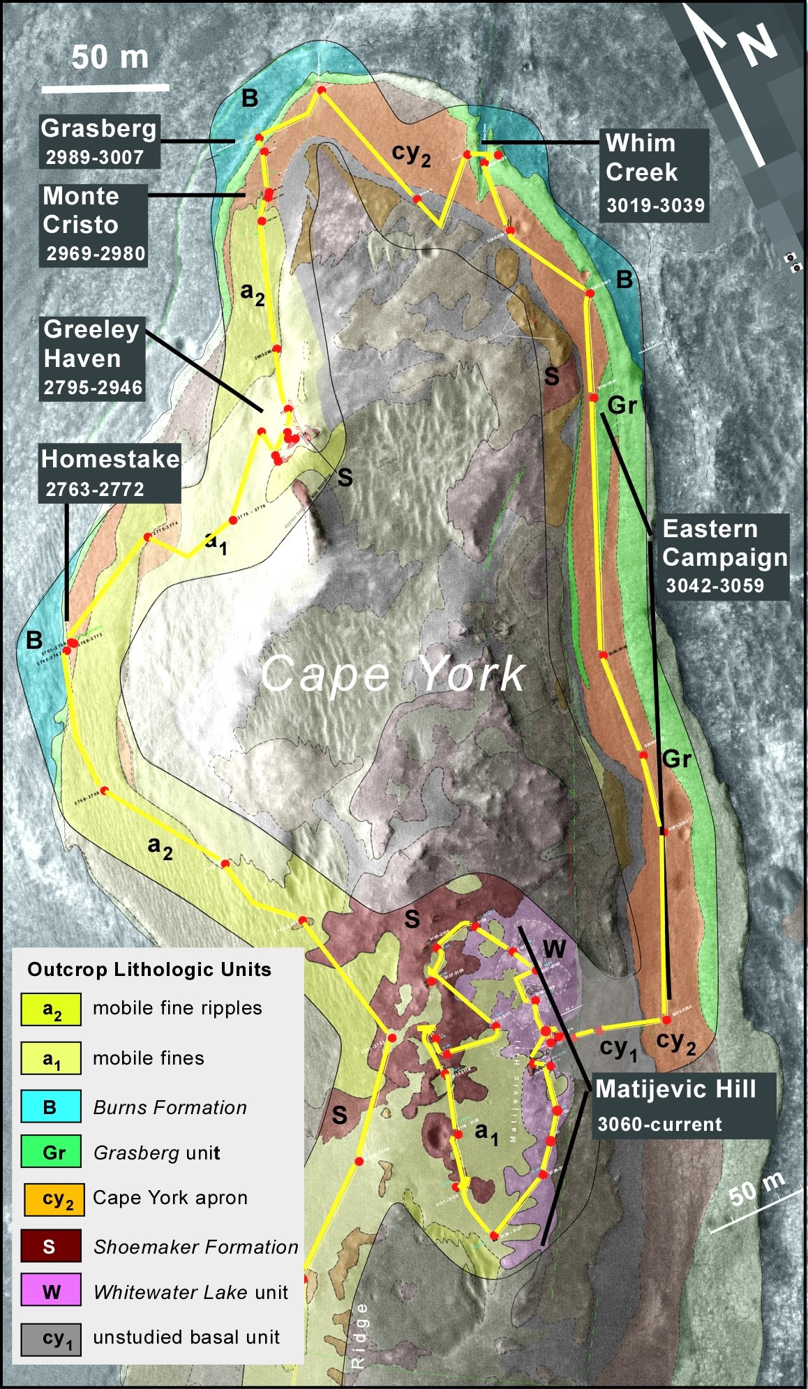
Geology of Cape York
MER's "resident mapper" Larry Crumpler created the field reconnaissance transect geologic map above with data Opportunity collected during her traverse around the margins and interior of Cape York. It is the first field reconnaissance transect geologic map on Mars.NASA / JPL-Caltech / University of Arizona / L. Crumpler
Rocks tell stories. When geologists walk across rocks of massively different ages, they can "see" different environments. "At the Endeavour rim, we went back in time geologically," said Crumpler. "We suspect that this is a piece of the ancient crust of Mars, and was there during an early phase of the planet's history. We're starting to see that evidence now across the planet, in a lot of the minerals, like possible clay minerals that are associated with the decomposition of rocks in the presence of lots of water. And it's water that is fairly neutral pH compared to the stuff for which Opportunity previously found evidence."
On Matijevic Hill, Opportunity conducted a survey, making a loop around the site, just like a geologist would do in the field here on Earth, to consider which outcrops to investigate in-depth to try and understand the context of the various rock layers there. "We're seeing a planet that's quite complex, and the further back we go in time, the more complicated it gets, and the more water was involved in the process of depositing and altering the rocks. That is what we always anticipated would be the case in the Noachian ancient highlands."
Even so, at the rover scale, what Opportunity, Crumpler, and crew have found is almost haunting in its familiarity: Mars is similar geologically to Earth. "That to me is so shocking," said Crumpler. "This is another planet and it's got a whole different history. Yet the geology is just like going in the field here in New Mexico, where you've got layers that mean different things because they were deposited in different environments, or in the Colorado Plateau province in the Southwest where there are gypsum veins that look just like the gypsum veins that we see at Endeavour. It really takes a lot of water, flowing deep in cracks in the ground, like our groundwater table, and fairly decent water by Earth's standards to make those gypsum deposits - that discovery alone practically is worth the entire mission," he noted.
Opportunity's research at Endeavour's rim has really only just begun, yet already the evidence for water having "done its alteration thing" for a very long time on some of these rocks is becoming obvious. "We're starting to see rocks that are pretty darn corroded and, ultimately, I think we are going to realize that this water was there for a long time - and it was very benign," said Crumpler.
That would mean these rocks were so water-logged for so long that in many cases they turned to clay. The water could have come from a lake or underground or perhaps snowmelt. "But we are not anywhere near being able to prove any one hypothesis yet," Crumpler cautioned.
One of the goals of geology, especially on another planet, is to see what's been going on through the eons. The big question for Mars has always been: 'Did Mars ever have environments where life could have started?'
"The fact that we can now say that Mars had lots of water, that the water was practically drinkable, and at the same time on Earth a similar environment existed when life was developing, is an exciting concept," said Crumpler. "It means that there is the potential for life elsewhere. These are exciting times."
Recent Results from the Opportunity Microscopic Imager
Presenter: Ray Arvidson for Ken Herkenhoff, U.S. Geological Survey (USGS)
Researchers: Ken Herkenhoff; Ray Arvidson and Brad Jolliff, WUSTL; Cathy Weitz, PSI Tucson; and the MER Athena Science Team
A fixed-focus camera mounted on Opportunity's instrument deployment device (IDD) or robotic arm, the Microscopic Imager (MI) takes photographs at a scale of 31 um/pixel over a broad spectral range (400 to 700 nanometers) of the target surface or, in other words, really, really close-up pictures. Put another way, it is the robot field geologist's hand lens.

Ken Herkenhoff
Ken Herkenhoff is a United States Geological Survey (USGS) Geologist, a member of the MER Athena science team, and a member of the Mars Science Laboratory/Curiosity team. Here, he takes a break to smile, while at work and play in the outdoor Mars Yard at the Jet Propulsion Laboratory (JPL), home to all the American rovers.From the collection of K. Herkenhoff
Since Opportunity can no longer directly sense phyllosilicate mineralogy - its Mini-TES and Mössbauer spectrometer are no longer working - the MER scientists are left to characterize the potential phyllosilicate host rocks by their texture with the MI, their color and to some extent their composition with the Pancam's imaging and multispectral capabilities, and their elemental chemistry with the APXS. The MI, as a result, is as critically important as ever.
Herkenhoff, a MER co-investigator and payload element lead for the MI, was sequestered (as a result of the inability of the legislative branch of the government to figure out a budget) and thus not able to present this work at the LPSC. "So in search for the closest looking science team member, we found one of similar height and furriness," said Session Chair Golombek in introducing Ray Arvidson.
"Ken sends his regrets," Arvidson said, opening the talk. "He is probably sitting in his office with his feet up looking north at the mountains, but would rather be here."
"While I do look at the mountains every once in a while, and even though I took advantage of not being at LPSC this year to catch up on other things, I do wish I had been there," Herkenhoff clarified later from his office with a view.
Although the MI has a dust cover, since the planet-encircling storm of 2007, dust contamination in the instrument's optics has reduced the contrast of the images. "It's basically scattering light, like when the windshield on your car gets dirty and you're driving into the Sun it gets hard to see," as Ken Herkenhoff put it during an interview following the conference. To compensate, the instrument team takes multiple pictures of the most significant science targets whenever possible as a workaround to increase the signal-to-noise ratio, thus improving the contrast and the pictures.
Despite the dusty lens, Opportunity has been returning scientifically important data from Endeavour Crater in the MI's telling images of the fine-scale textures of various outcrops. "It is exquisite data in terms of observations and it's been key to our understanding the texture to go along with the composition and remote sensing context," Arvidson said.
For any geologist anywhere, a hand lens to study textures is an essential tool. Looking at the fine textures of rocks and geologic features is, after all, how geologists have interpreted Earth history. "There's lot you can learn from the textures and orientations of the layers or beds, the crosscutting relationships - geologists have been using all those kinds of things on Earth for years to understand the history of the planet and they can also be applied to Mars using the data from the MI," Herkenhoff noted. "The MI data allow us, for example, to look at the shapes of the rock particles, the grain size, distribution, the sorting of these materials, and this information can help tell us about how the material was transported and formed."
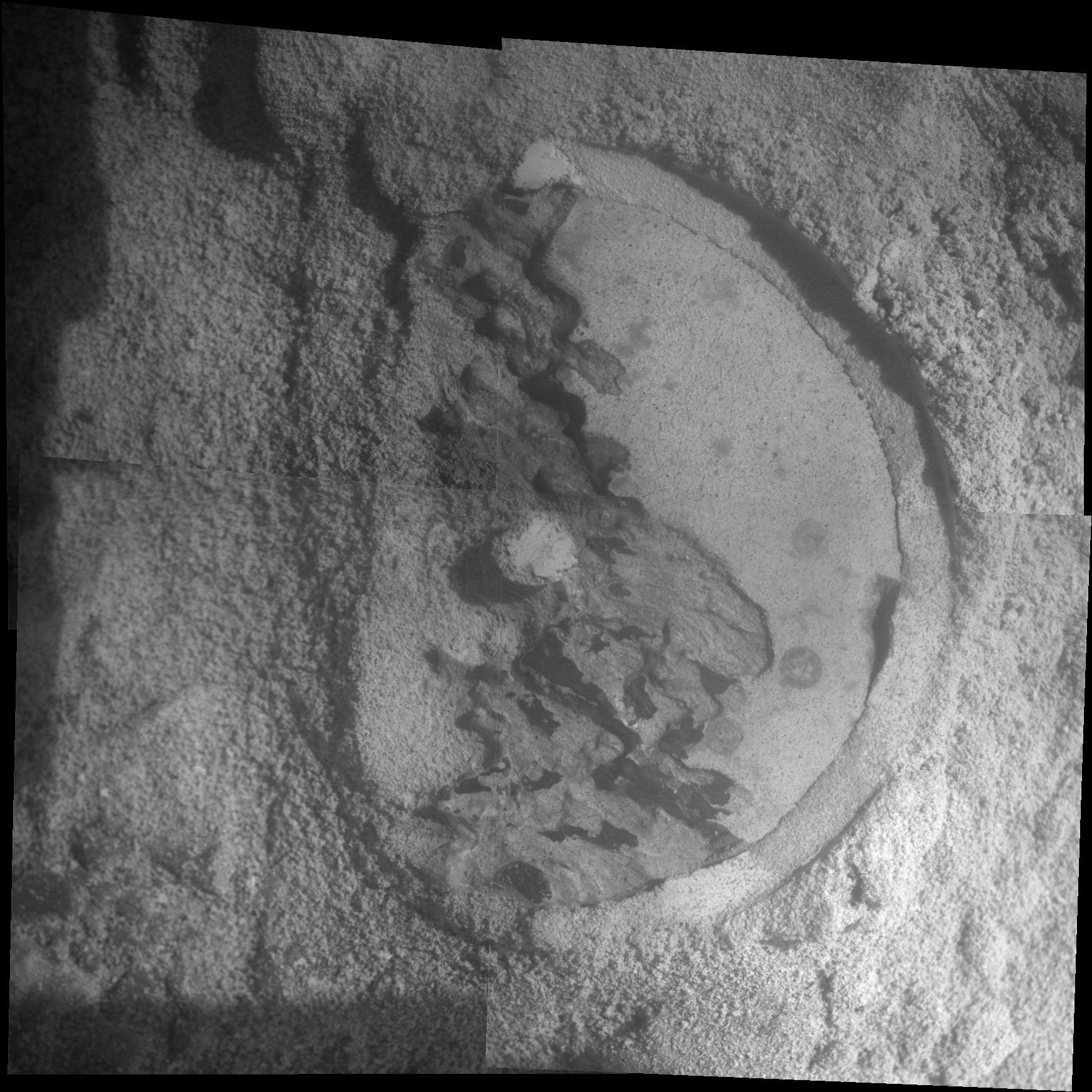
Newberry pie in a merger
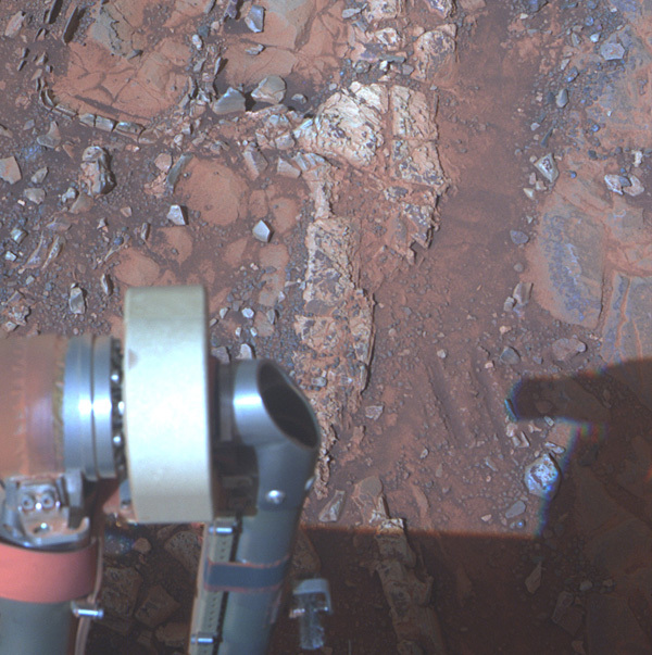
This picture is actually a merger of an MI mosaic and Pancam L257 de-correlation stretch color image of the outcrop Kirkwood, after being brushed with the rock abrasion tool (RAT). It was illuminated from the top. The area shown is about 5 centimeters across; redder, brighter dust has been removed from center area by brushing. Note structure visible in spherules that are exposed in cross-section near center. Spherules are between 1-4 mm in diameter and show alignments from upper right to lower left (arrows). Joel Hagen put together the MI mosaic, then Cathy Weitz merged it with Pancam color.NASA / JPL / Cornell / USGS / J. Hagen / C. Weitz
Since last August, Opportunity has been exploring Matijevic Hill, a distinctive rise along the inboard side of the Cape York segment of Endeavour Crater's western rim. At the foot of the hill, Kirkwood, a wild looking outcrop that sports a hardened fin, caused the scientists to "slam on the brakes and take a hard right turn," as Steve Squyres put it earlier in the session (and previously in an MER Update).
The geologic structure of Matijevic Hill area is complex and from the first images, as Arvidson showed during the conference, Mars presented surprises. At the foot of Kirkwood and all around the adjacent bright, flat Whitewater Lake outcrop, are tiny spherules, dubbed "newberries," that are unlike the hematite-rich "blueberries" or concretions the rover previously found all over the Meridiani Plains.
"The MI images of the spherules on Matijevic Hill indicate there was some kind of precipitation of minerals; therefore, aqueous alteration of them," said Herkenhoff. "Where the spherules are broken, they show a concentric texture that suggests that they grew radially. The spherules are all about the same size, which does not specifically indicate precipitation, but is consistent with it. And they are spherical, which again is not diagnostic but consistent with precipitation." This information helps the scientists put the spectroscopy and elemental chemistry data into context.
Although the origin of the Kirkwood outcrop remains uncertain, its setting on the rim of Endeavour suggests that the newberries were formed during an impact, perhaps the one that made Endeavour, or not. "The concentration of spherules in Kirkwood suggests that they were transported or at least concentrated into that area," Herkenhoff pointed out. "They may have been formed by an impact event before the Endeavour impact, and then sorted and concentrated in the ejecta blanket." There are multiple working hypotheses for their formation, with concretions from precipitation and lapilli being the two favorites.
Just behind Kirkwood, in the Whitewater Lake outcrop, which Squyres called the oldest layer of bedrock the rover has examined to date, Opportunity used her MI to photograph small, bright veins. The MI mosaic of the target Azilda revealed the bright, flat, outcrop to be mostly fine-grained, with dispersed spherules and resistant veins. "This target was easy to abrade using the RAT, and it exposed a sandstone-like texture but the sorting of grains is difficult to determine at MI resolution. Nevertheless, Herkenhoff wrote, "it is consistent with the possibility that this rock contains smectite,"
Of course, texture alone can't tell geologists everything they need to know about these outcrops. But the MI data along with the findings from the APXS, Pancam imaging and multispectral capabilities, and CRISM can tell them a lot.
From big veins coursing through the Bench, the apron area surrounding the base of Cape York, to newberries and tiny bright veins injected into Whitewater Lake, and even the breccia outcrops, "basically we're finding what we had hoped to find there," Herkenhoff said of Cape York. "We're seeing textures in the MI, very fine-grained textures in the areas where we think we're finding these phyllosilicates or these clay minerals, which is at least consistent with a lakebed type environment or something like that, a very quiet, perhaps even habitable environment."
Veins in Matijevic Hill Lithologic Units
Presenter: Bill Farrand, Space Science Institute Boulder
Researchers: Bill Farrand; Steve Ruff, Arizona State University (ASU); Melissa Rice, Caltech; Ray Arvidson and Brad Jolliff, WUSTL; Steve Squyres, Cornell; Andrew Knoll, Harvard University; Jim Bell, ASU; and J.R. Johnson, JHU-APL
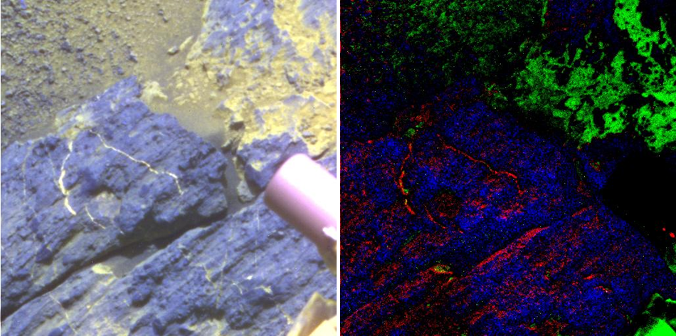
Not long after Opportunity arrived at Endeavour Crater in August 2011, it roved across a thick vein that cut through the bedrock in the Bench, an apron area surrounding the Shoemaker Formation, which is the spine of Cape York. Although the rover was in a hurry to get to its winter site, Greeley Haven, it stopped long enough to do a quick in-depth examination of the distinctive feature dubbed Homestake. It turned out to be composed of gypsum, a sign of a more alkaline or neutral pH water and the MER mission's first big discovery at Endeavour Crater.
Bill Farrand
Bill Farrand, a research scientist with the Space Science Institute in Boulder, Colorado, ia a participating scientist on the MER mission, and also works on research projects for NASA's Office of Space Science, Mars Data Analysis Program. An avid rock climber, he has worked extensively in terrestrial remote sensing as well as in the field of planetary science, and is an expert in the field of hyperspectral remote sensing, also known as imaging spectroscopy.Jim Rice
In recent months, the robot field geologist has found more veins, tiny veins shot through the Whitewater Lake layer on Matijevic Hill. "Veins on the Earth are always evidence of the action of water and are associated with all kinds of mineralized deposits," said Bill Farrand, who works with the Pancam multispectral data and has an extensive background in terrestrial remote sensing. "On Mars, we're particularly interested in the water story."
The Panoramic Camera (Pancam) is a stereoscopic, panoramic imaging system that features a high-resolution, color, stereo pair of CCD cameras used to image the surface and sky of Mars. Each "eye" of the Pancam carries a filter wheel that gives the instrument additional multispectral imaging capabilities. Since different minerals absorb and reflect light in distinct ways, multispectral images taken at well-selected wavelengths in the visible-to-near near-infrared provide information on the mineralogical composition and, potentially of the hydration state, of surface rocks and soils that the rover is looking at, data that supplement data obtained by other MER instruments.
Back in 2008, Alian Wang, of Washington University St. Louis, was looking at the spectral signatures of the silica-rich and sulfur-rich soils Spirit has been finding, and discovered there was consistently a downturn from the Pancam's 934 to 1009 nanometers spectral bands. Then, in 2009 Melissa Rice, as a grad student at Cornell, used Pancam multispectral imaging to detect hydration in the high silica deposits Spirit uncovered near Home Plate (where that rover now sits, a silent monument to exploration).
The MER scientists now know - while it is not conclusive evidence - a 934-to-1009 nanometer drop in reflectance in the Pancam multispectral data is consistent with the presence of some hydrated material. And Farrand and others are now using the technique regularly, since the rover's Mini-TES and Mössbauer spectrometer are no longer functioning.
During the conference, Farrand detailed Opportunity's investigations of Homestake and the tiny veins on Matijevic Hill, describing a number of the distinct textural and visible to near infrared (VNIR) spectral characteristics of the veins the rover investigated on Matijevic Hill with graphs and images. Indeed, Steve Squyres, et al., also found the drop in reflectance in the multispectral images of Homestake in 2009, enabling the MER science team to conclude that Homestake is composed largely of gypsum.
On Matijevic Hill, Opportunity found a number of distinct lithologic units. From the spherule-rich Kirkwood outcrop to the adjacent fine-grained Whitewater Lake and in the coarsely clastic Onaping units on Copper Cliff, veins are a common feature, "albeit smaller in scale and in some cases, with more complex patterns of exposure than those observed on the Bench unit of Cape York," Farrand, et al., wrote in the abstract. Unlike Homestake, these veins range in size from a few millimeters up to approximately 1 centimeter in width, and generally occur in what geologists call stockwork or boxwork patterns, which in some cases occur within a sub-rectangular fracture pattern.
Vermilion veins
These images show veins displaying a stockwork or boxwork pattern at a target called Vermilion in the Copper Cliff unit on Matijevic Hill. Opportunity took them with her Panoramic Camera or Pancam. Each "eye" of this stereo camera system carries a filter wheel that gives the instrument additional multispectral imaging capabilities. Since different minerals absorb and reflect light in distinct ways, multispectral images, like these, in the visible-to-near near-infrared provide information on the mineralogical composition. These are some of the images Farrand and other scientists worked with in reaching their conclusions about the tiny white veins on Matijevic Hill.NASA / JPL-Caltech / Cornell / ASU
Interestingly, these smaller veins show the same downturn in reflectance into the longest wavelength on the Pancam channel as Homestake did. This can be - but is not always - associated with certain minerals and materials that have an H2O overtone absorption centered near 995 nanometers, Farrand said. "Some minerals with water in their structure don't have this feature, but gypsum does. When we did chemistry on the smaller veins with APXS, we were able to find out they look like gypsum as well," he said during an interview after the conference.
Although Squyres and others interpreted Homestake and the larger veins investigated by Opportunity on the Bench unit with their dominant or exclusive gypsum composition to be the result of precipitation from low-temperature aqueous fluids flowing upward from the ancient materials of the rim, there is still debate about the cause of the smaller veins. Figuring out whether the small veins are gypsum like Homestake is now "really more of a geochemistry type story," said Farrand. "We saw calcium and sulfate, and so we have had some discussion as to whether they are gypsum or anhydrite or bassanite, which are also calcium sulfate bearing minerals. But those minerals don't show that hydration feature, that downturn in reflectance on the longest wavelength channel, so I'm pretty confident the calcium sulfate mineral in the smaller veins is probably gypsum."
That could mean the veins on the Bench and those on Matijevic Hill share a common origin, or not. The rocks that host the smaller veins may be ancient crater rim materials, or they could potentially be "pre-impact substrate exposed by the crater-forming event," Farrand noted. In that scenario, the veins would represent fractures formed by the impact event that formed Endeavour that were then filled during a contemporaneous or later episode of subsurface water flow. Also, the stockwork pattern of many of the veins, which contrasts with generally more linear trends among the gypsum veins observed in the Cape York Bench unit, provides evidence of greater and "likely a different mechanism of fracture development in the Matijevic Hill units," Farrand et al., concluded.
While the veins represent an important piece of the puzzle of the ancient environment[s] at this location on Mars, there's much more to uncover. The timing of vein emplacement, for example, is not known. "That's still something we need to work thorough and will probably involve looking at the structural geology, and how all the units kind of piece together," Farrand noted. "My sense is that they probably do have different origins or different water activity events that filled them because we saw the large veins on the Bench and then traversed other geologic units after that where there were no veins and then we get up into Matijevic Hill and see veins again."
The next objective, Farrand said, is "to try and get a better handle on what these veins are, what the aqueous events were, and where the elements came from."
Phyllosilicates such as iron-magnesium smectite minerals, generally form in water of a more neutral or alkaline environment, as opposed to the more acidic environments that Opportunity previously found in the Meridiani Plains. However, added Farrand, "we need to reconcile the presence of the sulfur in these veins with the potential smectites - and that will be something we'll be looking at in the future."
APXS Results from Matijevic Hill
Presenter: Barbara Cohen, NASA Marshall Space Flight Center (MSFC)
Researchers: Barbara Cohen; Ben Clark, Space Science Institute; Ralf Gellert, University of Guelph, Canada; G"ostar Klingelh"ofer, Institute for Inorganic and Analytical Chemistry at Johannes Gutenberg-University Mainz; Douglas Ming, Duck Mittlefehldt, Dick Morris, NASA JSC; Christian Schrader, NASA MSFC; Christian Schr"oder, Universit"at T"ubingen, Germany; Albert Yen, JPL; Tom Economou, University of Chicago; Paulo de Souza, University of Tasmania, Australia; Brad Jolliff, Ray Arvidson, WUSTL; Steve Squyres, Cornell, and the MER Athena Science Team.
Since Opportunity lost the use of its mineral detectors - the Mössbauer spectrometer last year and its Miniature Thermal Emission Spectrometer (Mini-TES) after the global dust storm in 2007 - the Alpha Particle X-Ray Spectrometer (APXS) has become a workhorse in the rover's toolkit. "It's very similar to an electron microprobe," said NASA geochemist Barbara Cohen, who has been a participating scientist on the MER mission since 2005.
Barbara Cohen
Barbara Cohen is a planetary scientist at NASA's Marshall Space Flight Center (MSFC) in Huntsville, Alabama. She became a member of the MER Science Team in 2005, examining the geochemical properties of impact products on the Martian surface and contributing to science team plans for the rovers’ investigations. She is an expert in the geochronology and geochemistry of meteorites.From the collection of Barbara Cohen
The APXS determines the elemental chemistry of rocks and soils using alpha particles and X-rays. A small alpha particle source in the instrument emits alpha particles that bounce back from a target and into a detector in the APXS, along with some X-rays that are created when elements are excited in the target in the process. "The energy of the X-rays is diagnostic of individual elements [in the targets], because each element has a specific electron make-up," explained Cohen, who currently serves as one of the APXS uplink/downlink leads and one of the leads for the MER science team's mineralogy and geochemistry group.
From those data, scientists can determine which different chemical elements have come together to form the minerals in the target rock or soil patch. And with that knowledge, they can then extrapolate bigger picture conclusions about the formation of the planet's crust, for example, or the kind of weathering that has taken place.
"We're looking for tell-tale element trends that would point to the rock's origin," Cohen explained during the post-conference interview. One trend Cohen and others have found at Endeavour indicates that the alteration processes between Cape York and Meridiani were different. Another trend shows the alteration of the Shoemaker Formation rocks, which form the 'spine' of the Cape York segment of Endeavour's rim and the Matijevic Hill rocks were similar, but Deadwood/Grasberg, a rock unit ringing the base of Cape York, may have undergone alteration under different conditions, possibly at a later time.
At Matijevic Hill, Cohen and others have been using the APXS to look at chemical trends in a Whitewater Lake outcrop to see if they point to the presence of the smectite clay minerals, as detected by CRISM and mapped to this specific location by MER Deputy Principal Investigator Ray Arvidson. "We can't determine a unique phyllosilicate signature with APXS, but using chemical trend in the rocks on Matijevic Hill, we may understand whether clay minerals are allowable components," Cohen said.
"The problem is that elemental makeup is not unique," she continued. "All rocks are made out of silicon, oxygen, etcetera, but the way the elements partition into minerals depends on how the rock formed." In addition, the irregular, splotchy veneers or coatings that appear on the Whitewater Lake outcrops are complicating analysis. In looking at various spots where there's different bedrock to coating ratios in the field of view, they found "no significant variation" in the APXS analyses that indicate the presence of smectite or another phyllosilicate as opposed to basaltic rocks. Even so, that data cannot rule out phyllosilicates, Cohen underscored.
Esperance
This mosaic of four frames shot by the microscopic imager on the robotic arm of NASA's Mars Exploration Rover Opportunity shows a rock target called Esperance after some of the rock's surface had been removed by Opportunity's rock abrasion tool, or RAT. The component images were taken on the rover's Sol 3305 day (May 11, 2013). The area shown is about 2.4 inches (6 centimeters) across. The APXS analysis of this led the science team to conclude Esperance is different than any other rock units Opportunity has seen.NASA / JPL-Caltech / Cornell / USGS
If Whitewater Lake outcrops contain smectite, this dataset implies that the rock has been isochemically altered to create the phyllosilicate content, she pointed out. Which is exactly what Ray Arvidson proposes. [See next section; MER Update for March 2013.]
Mars is a wonderland where things are not always what they may seem. After years of roving across the "big sandstone layer" that forms the Meridiani plains, Opportunity has finally been able to look at rocks that are older. "We thought initially that they must be related to the ejecta rim of Endeavor itself, because they're on the rim and they're high standing rocks," Cohen said. "But one of the great interesting discoveries here is that it's not immediately obvious what we're looking at came out of Endeavor itself. We thought it would be pretty obvious, and it's not."
During solar conjunction, which took place in April, after the LPSC, Opportunity effectively sat on a target in a Whitewater Lake outcrop called Esperance and took a lot of data or "integrated" nearly every day for two weeks. Although the APXS scientists can't detect clay minerals directly with the instrument, with long integrations like these, they can detect the presence of elements lighter than sodium.
"If we have enough data for a long enough time, we can look at the Compton and Rayleigh scattering and tell if there are excess light elements, things like oxygen, carbon, water, that the X-Rays cannot detect in the rocks," Cohen explained. It's a technique the MER science team has used before. Richard V. Morris, of NASA JSC, and others used this kind of APXS data from Spirit to find carbonate. "In a carbonate rock, carbon and oxygen would give you light element signatures," Cohen said.
At Esperance, another hint comes from element ratios that are different from normal basalts. "Elevated aluminum relative to silica is something that might come out in a clay mineral," she added. And in recent days, that's exactly what they found. In fact, Esperance/Whitewater Lake has a composition unlike any other bedrock outcrop Opportunity has investigated, higher in aluminum and silica, lower in calcium and iron.
"The team had a little side betting pool on how high the silicon and aluminum would climb in each successive analysis," Cohen revealed. "It's definitely one of the most exciting finds of the mission - it points to an extensively altered assemblage that likely formed as water flowed through the cracks in Whitewater Lake."
The Matijevic Hill outcrops are "expansive" and "complex." Yet, from the APXS data, they appear to share a common genetic origin. The scientists are still working on that, even though Opportunity has roved on.
"Going to Solander is really going to help us nail down what's happening here. At least we don't have any reason to believe that Solander is going to be a third set of rocks," Cohen said, pausing. "Then again, this is Mars."
Smectites on Cape York, Matijevic Hill, Mars, as Observed
and Characterized by CRISM and Opportunity
Presenter: Ray Arvidson, Washington University St. Louis
Researchers: Ray Arvidson, Keith Bennett, Jeff Catalano, Abby Fraeman, WUSTL; Ralf Gellert, University of Guelph, Canada; Ed Guinness, WUSTL; Richard Morris, NASA JSC; Scott Murchie, JHU/APL; Mike Smith, NASA Goddard; Steve Squyres, Cornell; and Mike Wolff, Space Science Institute, Boulder
The pressure was on Ray Arvidson, MER deputy principal investigator of Washington University St. Louis (WUSTL), to close the LPSC session with a bang, especially after Steve Squyres, the MER principal investigator and one of the researchers of the work, billboarded it three times during his talk. With nine-plus years on her rocker bogie, Opportunity is an aging rover. It's got a broken shoulder joint and its two mineral detectors aren't functioning anymore. Everyone knows getting the science data is not as easy as it used to be. Plus, the new rover on the other side of Mars is claiming the spotlight and making discoveries too.
Ray Arvidson
Ray Arvidson is the James S. McDonnell Distinguished University Professor at Washington University St. Louis. He is a professor in the department of Earth and Planetary Sciences, and also directs the Earth and Planetary Remote Sensing Laboratory. The most traveled living Mars geologist, Arvidson is MER's deputy principal investigator and is also a co-investigator on CRISM, the mineral detector onboard MRO, and on the MSL/Curiosity mission.Washington University St. Louis Magazine
Still, the MER team is legendary for brilliant, effective workarounds. In order for Opportunity to ground-truth the smectite clay minerals at Cape York, Arvidson got creative. Thinking 'outside the rover,' he came up with a workaround that is mission synergistic, using the Compact Reconnaissance Imaging Spectrometer for Mars (CRISM), onboard the Mars Reconnaissance Orbiter (MRO), as the rover's mineral detector.
Although CRISM first discovered phyllosilicates in the form of smectite clay minerals in the rim of Endeavour Crater in 2008, each pixel in that data covered a stretch of terrain 20 meters (65.61 feet) wide, swaths that contain various geological formations. So Arvidson, also a co-investigator on the CRISM team, spent many weeks with his team developing new approaches to retrieving mineral information from along track over-sampled (ATO) hyperspectral observations. The oversampling, a form of super resolution, allowed processing to 5 meters (16.4 feet) per pixel as opposed to the normal 18 meter per pixel CRISM data. He and his team also applied sophisticated approaches to remove atmospheric effects and then meticulously mapped the iron-magnesium smectite signature to a hill on the rim, ultimately producing a pixel-by-pixel map for vetting at LPSC.
That map, along with an intriguing looking, fin-bearing, richly layered outcrop they dubbed Kirkwood, led to Opportunity "slamming" on the brakes and "making a hard right turn" to explore the "sweet spot" of the phyllosilicate spectral signature on what they soon would call Matijevic Hill. "We gambled on the fact that we'd find some smectites," Arvidson said at the conference. [See MER Update August 2012]
In Opportunity's first pictures of Kirkwood, from the base of the hill, the MER scientists noticed a bright, recessive rock with an irregular, splotchy coating or veneer, just uphill and behind it, and nicknamed it Whitewater Lake. The Microscopic Imager observations showed that rock was very fine-grained, featured a relatively small component of irregularly shaped sand to silt-sized grains, bright veins, and a sprinkling of 1-2 millimeter diameter spherules.
As the robot field geologist conducted an extensive "walkabout" or survey of Matijevic Hill, it found more Whitewater Lake rocks and more outcrops composed of breccias formed and deposited during whatever event caused Endeavour Crater. "The easiest thing would have been to find the total composition of smectites, but we didn't see that," Arvidson said during the post-conference interview. "That indicates we have really low water-to-rock ratios, and the whole rock hasn't been turned into a clay."
On Earth, a small amount of corrosion of the minerals that produces smectites doesn't alter the chemistry much, but it does change the phases of the mineral. "Without the Mini-TES or Mössbauer to pin down the presence of the smectite phase, we have to use CRISM as our mineral detector," Arvidson said. "The Whitewater Lake outcrops map one to one with where CRISM data indicate the presence of smectite exposures." [A paper on this work is in preparation.]
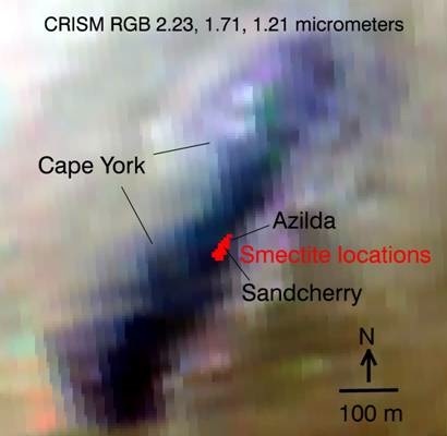
One-to-one
The red areas designate the location where CRISM detected smectite clay minerals on Matijevic Hill, according to Ray Arvidson's pixel-by-pixel map. They are positioned directly over Whitewater Lake outcrop. "That's where the clays are," said Steve Squyres. "Case closed."NASA / JPL-Caltech / JHUAPL
Additionally, the Whitewater Lake rocks are not only in the CRISM "sweet spot," they look "interesting" and "different than any rocks Opportunity seen before," and their "finely layered nature" are consistent with clay minerals, said Arvidson. Moreover, these rocks have been "pretty extensively cut and filled in with gypsum veins," he noted, which speak to the presence of flowing neutral to alkaline water after the rocks were deposited. And the strange dark veneers on these flat, veined rocks imply a unique ability to form surface deposits, perhaps during emplacement, "likely enabled by surface water as small amounts of frost or snow melt," Arvidson et al., wrote. The veneers may represent darker layers within the deposit that have been exposed by wind erosion.
While the MER scientists do not know when exactly the water flowed here or when the Whitewater Lake strata were altered, they do know the chemistry of these bright, flat, coated outcrops and related strata, including the Kirkwood and Copper Cliff outcrops, are compositionally distinct from the Shoemaker Formation breccias uphill.
The fact that APXS data do not show any "significant variation" in the rock's chemistry that indicated the presence of smectite (noted in Barbara Cohen's presentation) was at first puzzling for many MER observers. But not for Arvidson or other MER scientists. "There are many examples of mild aqueous weathering on Earth that produce smectites from basalts without altering the chemistry," Arvidson said. "Everything goes together in the model."
Analyses of APXS data results from all the rocks measured in Cape York show that the Whitewater Lake deposits are more enriched with silicon dioxide [SiO2], aluminum oxide, [Al2O3] and sodium oxide [Na2O], which Arvidson pointed out later, suggests aqueous alteration of olivine and pyroxene, and formation of smectite, relative to more insoluble feldspars.
With Opportunity's APXS findings of the elemental chemistry of Matijevic Hill rocks, the distinctions in grain sizes, shapes, and fine layering that are visible in the Pancam and MI photographs, the MER mission has provided critical new constraints on the processes that emplaced these clay-bearing rocks on ancient Mars. And with his talk at LPSC, Arvidson presented a new way to continue the MER exploration on Mars, convincingly asserting that Opportunity has chalked up another first, ground-truthing the presence of smectite clays in the oldest bedrock the rover has ever come across.
Onward to Solander Point
"Ray showed compellingly that the CRISM clay signature at Cape York is directly locked up in this little window into the subsurface that we found at Matijevic Hill, called Whitewater Lake," Squyres said unequivocally after the conference. "That's where the clays are. Case closed."
Even with that remarkable science delivered, Matijevic Hill wasn't an easy place to leave. But the solar powered rover has to be at Solander Point by August and positioned with its solar arrays to the winter Sun in the north, before the season descends and sunlight decreases - and it's a 2-kilometer journey at the least. The team had already made the decision Opportunity would be leaving, not staying at Cape York, but they extended the exploration right up to the last minute almost. They had good reason.
Esperance, the last target on one of the Whitewater Lake outcrops on Matijevic Hill that Opportunity investigated in-depth, was "so important," said Squyres, the mission lingered there to complete several weeks of APXS analysis, even though they knew "the clock was ticking."
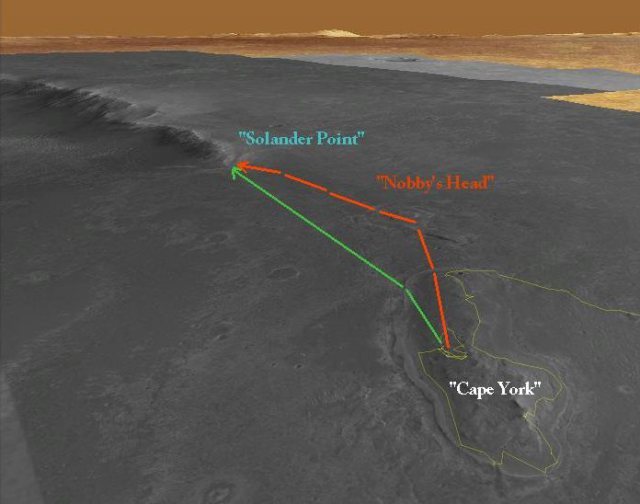
NASA / JPL-Caltech / UA / S. Atkinson
Onward to Solander Point
Opportunity is currently en route from Cape York to Solander Point, where it will spend its sixth Martian winter. If there is time, some of the scientists want to make a quick research stop at Nobby's Head slight off course. Time will tell soon. The solar powered rover is so dusty now it must park on a slope to angle its solar arrays north toward the winter Sun to take in as much fuel as possible if it is going to be able to work through the season. Stuart Atkinson did the annotations for this overhead map, overlaying them an image taken by the HiRISE camera onboard the Mars Reconnaissance Orbiter. See Stu's blog: http://roadtoendeavour.wordpress.com/In the end, as NASA/JPL just recently announced, Esperance had been "intensely altered by water." It provided a dramatic end to the first chapter of the MER book on Endeavour.
As Opportunity's expedition at Endeavour continues, the rover and the MER scientists have their sites set on what's ahead, well aware it may tell them more about what they just left behind. At Solander Point, Opportunity will be roving onto more extensive deposits of ancient rocks and the MER science team plans to continue unraveling the geological history of Endeavour as her exploration continues there.
"Even from Opportunity's current position, Solander Point shows evidence for dark and bright layering with a much thicker section of exposed rim rock compared to what was found on Cape York," Arvidson noted.
As Opportunity's expedition at Endeavour continues, the rover and the MER scientists have their sights set on what's ahead, well aware it may tell them more about what they just left behind. They have a feeling that what they find there will bolster the picture that is beginning to emerge of an ancient environment where an abundance of water flowed, the kind of water that makes clays and runs through veins. Like every good mystery, this one is not over yet. Stay tuned.
Protect Our Shared Future
You help us defend humanity and prevent asteroid impacts. Donate now to become a Planetary Defender!
Donate