Emily Lakdawalla • Jan 29, 2014
Curiosity update: imaging the nonfunctioning REMS boom, closer to Dingo Gap
At last, Curiosity has attempted -- and succeeded at -- imaging REMS Boom 1.
Here's a little background to explain why this was both necessary and difficult. REMS stands for the Rover Environmental Monitoring Station; it's a large suite of instruments located all over the rover that measure weather-related data like wind speed, temperature, and pressure. REMS is the instrument suite that gives you daily weather reports from Mars. They've been doing great work.
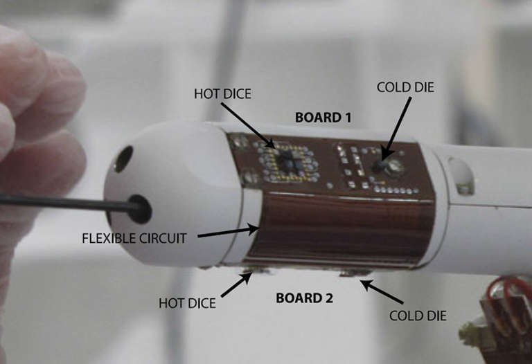
In the only sad event that marred the triumphant day of landing, one small part of the REMS instrument suite failed to work properly: the wind sensor. The wind sensor suite consisted of two instruments on two short booms sticking out like pointy fingers from the rover's mast. One of the booms (Boom 2) points forward, while the other boom points back and to the rover's right (Boom 1). On each boom, there are three exposed circuit boards, connected together by two sections of flexible circuit, exposed to the Martian air. Based on the data they receive from the rover, the REMS team thinks that one or more of the circuit boards on Boom 1 was damaged during landing, perhaps by a flying bit of gravel like the ones that were visible on top of the rover deck after landing.
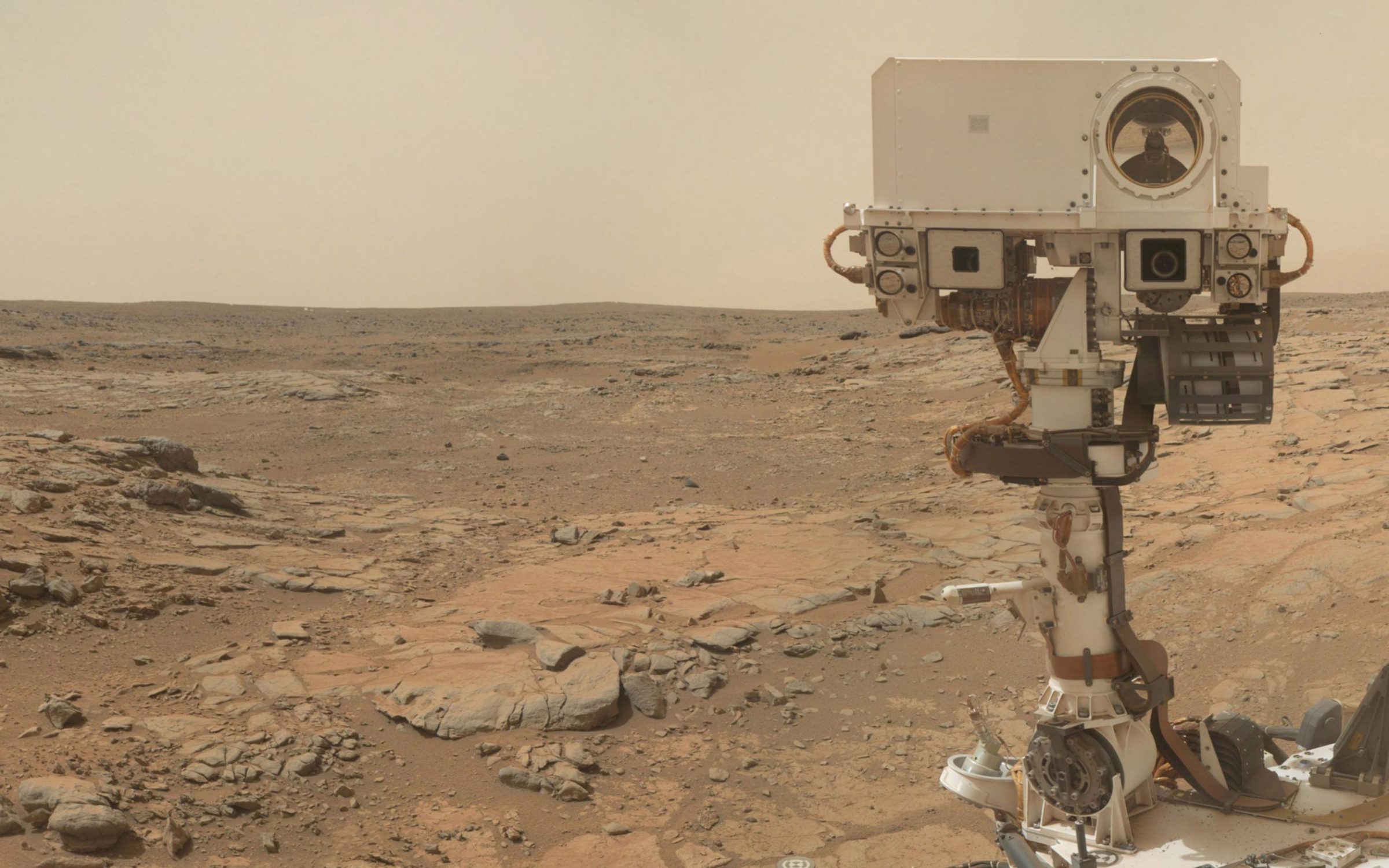
Since landing, Curiosity observers and team members alike have asked: can we just get a photo of Boom 1 to see what the problem is? Unfortunately, that was easier said than done. Boom 2 is easy to see, on the front side of the rover; it's been imaged numerous times by the MAHLI camera on the end of the rover's arm when it takes self-portraits. It works just fine, though its data is much more difficult to interpret without useful data from Boom 1. You can see Boom 2 in this photo, sticking out at left of the mast.
But Boom 1 is in a location on the opposite side of the mast from the arm and it was not obvious whether MAHLI could be positioned to see it, or if it could be held in a position to see the boom, if it could get close enough to get any detail.
Well, on sol 526, they managed to do it. For a little context, here's an unfortunately very tiny diagram of the way the circuit boards are laid out on the instrument:
And here's an annotated diagram of one boom, taken from the scientific paper describing the REMS instrument (which you can download here as a PDF):
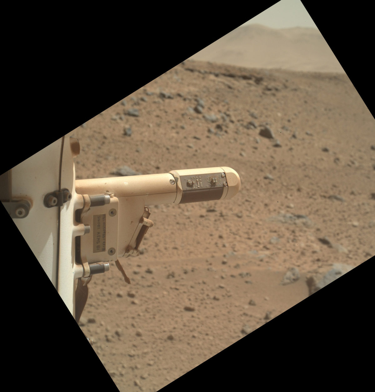
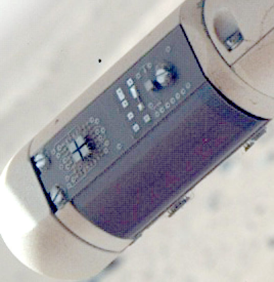
The first picture from sol 526 is taken from a perspective from the front side of the rover, looking toward the back; you can see one of the three electronics boards and one of the sections of flexible circuit; you can see the little cube-shaped "sensor dice" protruding from a second electronics board underneath the boom.
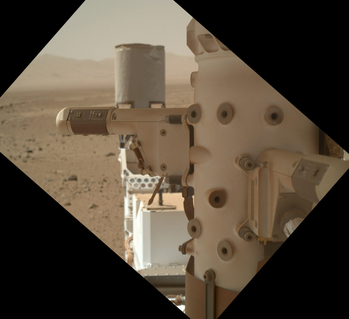
Then they repositioned the arm and took another picture. I've played with my LEGO rover model for a while and I cannot quite figure out how they managed to position the arm to get this photo. I guess the arm must have been reaching across the rover's "back." We're seeing the opposite side of the boom, which means the camera was behind the boom. We can see the other of the two flexible circuit tapes and the third electronics board.
I've stared at both pictures for a while and don't see any obvious signs of damage to either of the two visible boards or flexible circuit. Here are zoomed views. It's possible that some sign of damage is hidden in the JPEG compression artifacts but there's certainly no big puncture or missing "dice" or anything else obvious to point at. There is one funny bright spot with a long vertical streak on the flexible circuit on the front-view image, but that's just a hot pixel on the MAHLI camera detector -- it's not anything on the REMS boom.
The mission has better-quality pictures than these, so maybe they see something I don't. I didn't bother to ask anyone, knowing they wouldn't have anything to say to me alone -- when commenting on any problem with the rover, it has to wait until they're ready to make a public statement. We'll hear something eventually. If we don't, I'll ask a question about it at their next press briefing.
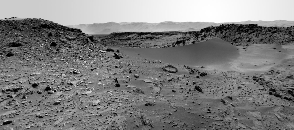
In the meantime, they're pressing ahead toward Dingo Gap, with a 30-meter drive yesterday, sol 527. That round rim of a rock in front of the dune is certainly a curious shape! Ken Herkenhoff says they're planning to drive onto the dune on sol 528 to assess its trafficability. (I imagine they'll do a "toe dip," driving just the front wheels onto it, to assess how much they slip, but we'll have to wait and see.)
Just after I initially posted this update, the mission posted a "status report" concerning their reasons for driving toward Dingo Gap. It's chock-full of information, so I'm going to just post the whole thing here.
January 29, 2014
Mars Science Laboratory Mission Status Report
The team operating NASA's Mars rover Curiosity is considering a path across a small sand dune to reach a favorable route to science destinations.
A favorable route would skirt some terrain with sharp rocks considered more likely to poke holes in the rover's aluminum wheels.
While the team has been assessing ways to reduce wear and tear to the wheels, Curiosity has made progress toward a next site for drilling a rock sample and also toward its long-term destination: geological layers exposed on slopes of Mount Sharp. The rover has driven into a mapping quadrant that includes a candidate site for drilling. Meanwhile, testing on Earth is validating capabilities for drilling into rocks on slopes the rover will likely encounter on Mount Sharp.
Curiosity has driven 865 feet (264.7 meters) since Jan. 1, for a total odometry of 3.04 miles (4.89 kilometers) since its August 2012 landing.
Accumulation of punctures and rips in the wheels accelerated in the fourth quarter of 2013. Among the responses to that development, the team now drives the rover with added precautions, thoroughly checks the condition of Curiosity's wheels frequently, and is evaluating routes and driving methods that could avoid some wheel damage.
A dune about 3 feet (1 meter) high spans the gap between two scarps that might be a gateway to a southwestward route over relatively smooth ground. Curiosity is approaching the site, "Dingo Gap," from the southeast. The team is using images from the rover to assess whether to cross the dune.
"The decision hasn't been made yet, but it is prudent to go check," said Jim Erickson of NASA's Jet Propulsion Laboratory, Pasadena, Calif., project manager for Curiosity. "We'll take a peek over the dune into the valley immediately to the west to see whether the terrain looks as good as the analysis of orbital images implies." The orbital images come from the High Resolution Imaging Science Experiment (HiRISE) camera on NASA's Mars Reconnaissance Orbiter.
Other routes have also been evaluated for getting Curiosity from the rover's current location to a candidate drilling site called "KMS-9." That site lies about half a mile (800 meters) away by straight line, but considerably farther by any of the driving routes assessed. Characteristics seen in orbital imagery of the site appeal to Curiosity's science team. "At KMS-9, we see three terrain types exposed and a relatively dust-free surface," said science team collaborator Katie Stack of the California Institute of Technology, Pasadena.
Before Curiosity's landing inside Gale Crater, the mission's science team used images from orbit to map terrain types in a grid of 140 square quadrants, each about 0.9 mile (1.5 kilometers) wide. Curiosity landed in the "Yellowknife" quadrant and subsequently crossed parts of quadrants called "Mawson" and "Coeymans." This month, it entered the "Kimberley" quadrant, home of KMS-9.
Stack said, "This area is appealing because we can see terrain units unlike any that Curiosity has visited so far. One unit has striations all oriented in a similar direction. Another is smooth, without striations. We don't know yet what they are. The big draw is exploration and seeing new things."
Science investigations have continued along with recent drives. One rock examined on Jan. 15, "Harrison," revealed linear crystals with feldspar-rich composition.
To prepare for destinations farther ahead, engineers are using a test rover at JPL to check the rover's ability to tolerate slight slippage on slopes while using its drill. With the drill bit in a rock, tests simulating slips of up to about 2 inches (5 centimeters) have not caused damage.
"These tests are building confidence for operations we are likely to use when Curiosity is on the slopes of Mount Sharp," said JPL's Daniel Limonadi, systems engineering leader for surface sampling with the rover's arm.
Other testing at JPL is evaluating possible driving techniques that might help reduce the rate of wheel punctures, such as driving backwards or using four-wheel drive instead of six-wheel drive. Some of the wheel damage may result from the force of rear wheels pushing middle or front wheels against sharp rocks, rather than simply the weight of the rover driving over the rocks.
"An analogy is when you are rolling your wheeled luggage over a curb, you can feel the difference between trying to push it over the curb or pull it over the curb," said JPL's Richard Rainen, mechanical engineering team leader for Curiosity.
While continuing to evaluate routes and driving techniques, Curiosity's team will add some weekend and evening shifts in February to enable planning more drives than would otherwise be possible.
NASA's Mars Science Laboratory Project is using Curiosity to assess ancient habitable environments and major changes in Martian environmental conditions. JPL, a division of the California Institute of Technology in Pasadena, built the rover and manages the project for NASA's Science Mission Directorate in Washington. For more information about Curiosity, visit http://www.nasa.gov/msl and http://mars.jpl.nasa.gov/msl/ . You can follow the mission on Facebook at http://www.facebook.com/marscuriosity and on Twitter at: http://www.twitter.com/marscuriosity .
The Time is Now.
As a Planetary Defender, you’re part of our mission to decrease the risk of Earth being hit by an asteroid or comet.
Donate Today

 Explore Worlds
 Find Life
 Defend Earth


