
 Explore Worlds
 Find Life
 Defend Earth


Mars Exploration Rovers Update: Spirit and Opportunity Wrap Year 4, Ready to Rove into 2008

Written by
A.J.S. Rayl
Contributing Editor, The Planetary Society
December 31, 2007
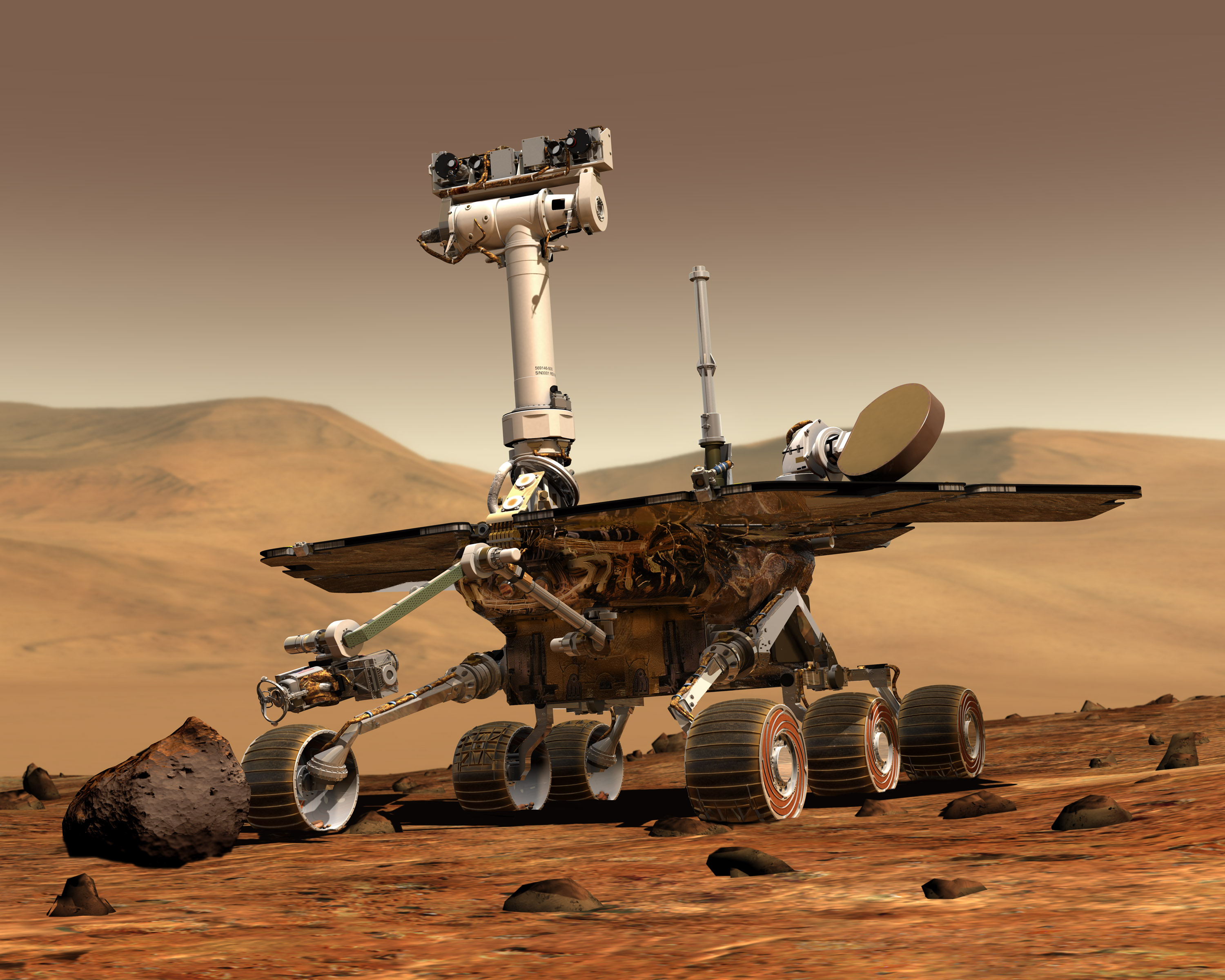 Mars Exploration Rover
Credit: NASA/JPL/Maas Digital
The mission was only supposed to last three months, maybe six months if all went well, but the Mars Exploration Rovers surprised everyone. Demonstrating an uncanny kind of “robot right stuff,” they roved far beyond what anyone dreamed and now, in a matter of days, Spirit and Opportunity will celebrate their 4th birthdays and rove into their fifth year of exploring the Red Planet.
"These rovers have gone far beyond all our expectations," said Steve Squyres, of Cornell University, the chief scientist for the MER science payload. "You could make a good argument that scientifically it was Spirit's biggest year. Opportunity has been working over Victoria Crater pretty thoroughly. It's a big, big feature and there's a lot to be done there."
All in all, Squyres summed up, "it was a really good year."
That might be something of an understatement, actually. Despite their aging frames and the harshness of the Martian landscape and brutally frigid weather, Spirit and Opportunity both logged banner years in 2007 -- if only by enduring a wicked global dust storm for which they were not designed. More than that, however, each rover returned important new evidence to add to the story of water on Mars and pushed the envelope of planetary exploration.
The rocky environment of the Gusev Crater region has made exploration tough for Spirit, which lost the use of its right front wheel about two years ago, and things didn’t get any easier in 2007. Still, nothing seemed to stop this rover.
In fact, Spirit, which turns four on January 3, 2008, serendipitously dug up one of the mission's “top five discoveries,” as Squyres has defined it, just seven months ago. While dragging its broken right front wheel through the Inner Basin of the Columbia Hills at Gusev Crater in May, it accidentally churned up near-pure silica around the circular volcanic formation dubbed Home Plate. On further inspection, the rover found silica-rich soil patches and rocks all around Home Plate, leaving virtually no doubt that water once percolated through this area.
"The discoveries in Silica Valley were big," Squyres reiterated recently. "We have found I think the most compelling evidence yet for hydrothermal activity … the kinds of stuff that would be very attractive from the sample return perspective. In many ways, despite the low power and busted wheel and everything else, that the Silica Valley campaign was perhaps Spirit's finest hour."
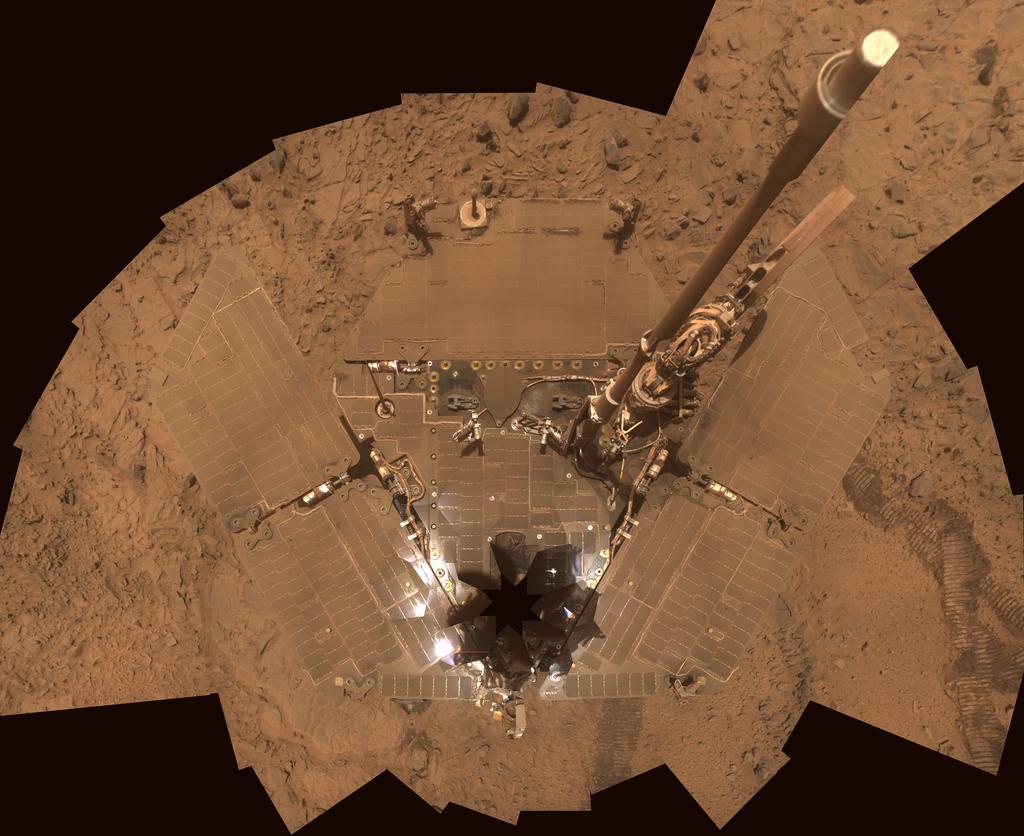 That darn dust
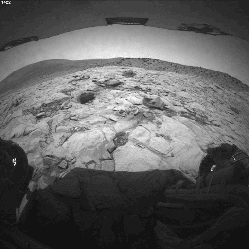
Spirit's deck is so dusty that the rover almost blends into Martian landscape in this image assembled from frames taken by the Pancam from Sol 1355 through Sol 1358 (Oct. 26-29, 2007). Dust on the solar panels reduces the amount of Sun-power the rover can take in and thus reduces its energy. The vertical projection used here produces the best view of the rover deck, though it somewhat distorts the ground and antennas. The eight-pointed star shape near the front of the rover (bottom of image) marks the location of the camera mast, which is out of view of the Pancam atop the mast.
Credit: NASA / JPL-Caltech / Cornell
The rover's bad wheel does slow it down though and it took Spirit most of this month to find and get to its current position off the northern edge of Home Plate, where it will hunker down for its third Martian winter. During the week before Christmas though, the rover deftly descended over the edge of Home Plate North and parked at a 13-degree tilt, to take in as much sunlight "fuel" as possible.
Spirit will continue to inch farther down as winter sets in, angling its solar arrays to follow the Sun, eventually reaching a 25 to 30-degree tilt. Even if it hibernates and goes to low power for a while in the New Year, which is part of the plan, this rover is going to need all the power it can glean to survive this winter, because the dust that has accumulated on its solar arrays from the summer’s global dust storm is blocking a lot of the sunlight and the depths of the season in the planet’s southern hemisphere won't pass until next July.
For now, "Spirit is doing fine," Squyres said. "We could stand a little wind gust," he admitted, "but otherwise things are going well."
While Spirit was making news in 2007 with its discovery of silica-rich soils and rocks at Gusev, Opportunity, on the other side of the planet, was taking pictures of the best examples of cross-bedding ever found on Mars at Victoria Crater where it first arrived in September 2006. Some of the super-resolution images it sent home of the cliff faces that scallop the rim this past year are literally jaw-dropping and now are revealing new details about the ancient environments there.
 Opportunity on Cape Verde
This artist's concept of the Mars Exploration Rover Opportunity is superimposed on the rim of Victoria Crater to offer a sense of scale. Credit: NASA / JPL / Cornell
This month, Opportunity continued research on the tri-layer rock ring that circles the interior of the 800-meter (half-mile) diameter hole in the ground. After finishing up its study of Smith2, a target on the second layer, it roved a few meters farther down into the crater to the target named Lyell, the third and darkest layer in the rock ring.
"We're making good headway," Squyres said. While Opportunity's findings are still being analyzed, they're intriguing enough, he said, for the rover to continue its field work there longer than initially intended. "Both the data we're getting down in the crater from this bright band and the tantalizing stuff we're seeing with some of our imaging over towards Cape Verde are indications that there's an awful lot more to be learned here."
Since Opportunity is located closer to the equator than its twin and has consistently sported higher power levels, its prospects for surviving this third Martian winter are significantly better than Spirit’s. As a result, the rover handlers are anticipating Opportunity will cruise through the coming winter with relative ease.
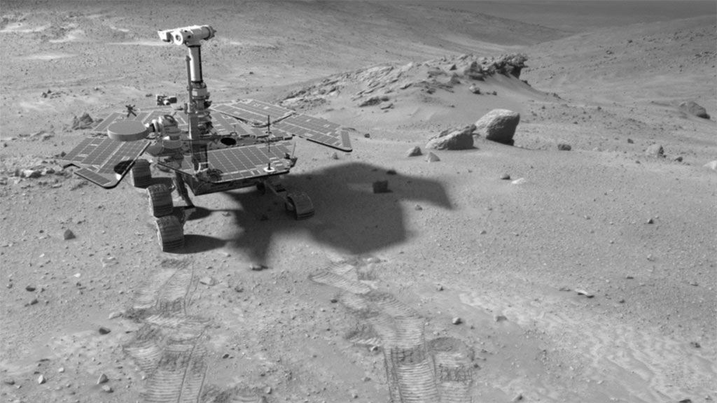 Spirit in the Columbia Hills
This FX or manufactured image of Spirit in the Columbia Hills was produced using "Virtual Presence in Space" technology, developed at the Jet Propulsion Laboratory, where the rovers were designed and built. This technology combines visualization and image-processing tools with Hollywood-style special effects to create a realistic image comprised of a photorealistic model of the rover and an image taken by Spirit with its navigation camera on Sol 438 (Mar. 27, 2005). The size of the rover in the image is approximately correct and was based on the size of the rover tracks in the navigation-camera image. Since such syntheses provide viewers with a sense of their own "virtual presence," such views can be useful to mission teams in planning exploration by enhancing perspective and a sense of scale. Dan Maas creted the MER model; synthetic image by Koji Kuramura, Zareh Gorjian, Mike Stetson and Eric M. De Jong.Credit: NASA / JPL-Caltech
Taking all this into consideration, it wasn’t surprising that at the annual fall meeting of the American Geophysical Union (AGU) held December 10-14, in San Francisco, California, Spirit was front and center at a press conference where Squyres and MER project manager John Callas, of the Jet Propulsion Laboratory (JPL), updated the scientific community on rovers’ latest adventures and findings.
“Spirit is going into the winter with much more dust on its solar panels than in previous years, because the storm that we survived dumped a lot of dust onto the solar arrays," reminded Callas. During the last Martian winter, Spirit didn't move for about seven months. This time around, he said, it’s likely to be stationary longer and with “significantly lower available energy” each Martian day. "It's going to be a much more challenging season for Spirit than the previous two Martian winters."
No one, no how, is giving up on this determined little ‘bot. For now, the engineers at JPL, where the twin robot field geologists were designed and are being managed, remain optimistic that Spirit will once again pull through.
2007: A Look Back
Spirit and Opportunity sent back volumes of new data about Gusev Crater and Meridiani Planum in 2007 and established a number of new rover records. Both MERs chalked up their second Mars Year in October, which is slightly less than four Earth years. On August 24, Spirit roved into the history books overtaking Viking 2 as the second longest-lived robot on Mars while Opportunity broke its own driving record in June as it crossed the 11-kilometer mark on its odometer, which is just under 7 miles.
Spirit and Opportunity also continued to push the planetary exploration envelope in 2007, working with the Mars Reconnaissance Orbiter (MRO) and the European Space Agency’s Mars Express orbiting above to further test the communication network now in place at Mars, as well as conduct collaborative studies of the Martian atmosphere and specific sites on the ground.
For the first time in planetary exploration history, an orbiter aided in the planning of ground-truthing rovers below and is now added to their findings about water in the Martian regions of Meridiani Planum and Gusev Crater.
 Opportunity ready to roll
This image shows a simulated Opportunity ready to descend into Victoria Crater via the rock-paved slopes of an alcove dubbed Duck Bay. With slopes of about 15 to 20 degrees and exposed bedrock, it was the safest route in. The rover is now inside the crater examining a triple-layer rock ring that circles the interior in search of clues about Mars' wet past.
Credit: NASA / JPL-Caltech / Cornell
Images from the High Resolution Science Imaging Experiment (HiRISE) camera and data from the Mars Climate Sounder and MARCI onboard MRO helped the MER team help its charges survive the global dust storm that hit in June. New mineral maps and HiRISE images are now helping the MER scientists put the rovers' findings this past year into broader geological context. Complementary studies of the Meridiani region from orbit show, for example, that clay-rich deposits and ancient cratered terrain cut by fluvial channels underlie the thick stack of sulfate-rich layers that Opportunity is now sampling from the top.
Beyond that, HiRISE pictures for the first time showed the discernable shapes of the rovers below, as well as their tracks and even the shadows of their masts.
The rovers’ support team on Earth also earned notice. In April, at the close of the British Rocketry Oral History Programme's 2007 Conference in Surrey, England, the MER team received the 2007 Sir Arthur C. Clarke Award for Best Corporate or Team Achievement. Steve Squyres accepted the award for Best Individual Achievement.
Spirit From Gusev Crater
For Spirit, always the more challenged of the two MERs, the life-and-death drama that has come to define its robot character continued in 2007. Even as the New Year rang in last January at JPL's Mission Control, a storm was dusting this rover in the Inner Basin of the Columbia Hills at Gusev Crater. The storm created a cloud of concern that hung over the MER team throughout the New Year's holiday one year ago. The rover was forced to "emergency evacuate" Esperanza, the intriguing, spongey-looking rock, and head for a northern slope to get enough sunlight to stay alive. True to its MER medal, Spirit rallied and promptly got back to work, first investigating an outcrop named Troll, then returning to the Tyrone soil patch for another, closer look.
 Esperanza up-close
Spirit took this raw, close-up image of Esperanza, a vesicular basalt rock, with its microscopic imager (MI)on Sol 1053 (Dec. 19, 2006). The MER science team has seen a number of these rocks pitted with holes in the Inner Basin, but this is the first one to be examined in detail. It may have come from Home Plate, which science team members now believe is an eroded-over volcano.Credit: NASA / JPL
From Tyrone, Spirit headed back to Home Plate, the 2-meter (6-foot) circular plateau that most team members identified as a volcanic formation and had long been wanting to revisit. But the plan evolved in March. Instead of roving onto the top of the concave plateau, the rover turned around and drove to Mitcheltree Ridge, across from the eastern perimeter of Home. There, it examined a large slab of rock, Torquas, which presented "a terrific geologic puzzle," as Squyres described it. The slab was loaded with tiny millimeter-sized spherules that seem just like the ones Opportunity has found all around Meridiani Planum, except for one thing: they contain no hematite, a mineral which almost also forms from a process involving water, at least on Earth.
In April, a dust storm in the Hellas region darkened Spirit's energy briefly, but it blew itself out pretty quickly. The MERs escaped Mars' wrath one more time and Spirit carried on with its compelling investigation just a few meters from Home Plate. It was studying an unusual outcrop with strange node features, called Elizabeth Mahon, after a player from the All-American Girls Professional Baseball League like the other targets in the area. Elizabeth Mahon turned out to be a real star on Mars, boasting a composition of 72% silica --the highest amount of silica seen to that point on the mission and a sure sign of water. Once again, the rover's slide up onto Home was delayed. It had little choice but to check out some more rocks and patches of soil in the area.
One soil patch Spirit churned up in May had science team members doing double-takes -- and later back flips -- and it was all because of the rover's bum wheel. "Having a right front wheel that doesn't work is a very difficult thing to deal with," Squyres explained. "You have to drive backwards, dragging the wheel and it's very difficult to maneuver. However there is a silver lining. The silver lining is that as we drive, we dig this wonderful hundreds of meters long meters trench as we drive through the Martian soil and every once in a while something interesting pops up in that trench."
 Silica Valley
The patch of bright-toned soil dubbed Gertrude Weise that Spirit churned up back on Sol 1150 (Mar 29, 2007) turns out to be so rich in silica that scientists are convinced water must have been involved in concentrating it. Most of the patches of disturbed, bright soil that Spirit had investigated previously are rich in sulfur, but this one, roughly 20 centimeters (8 inches) wide, has very little sulfur and is about 90% silica. The rover took this approximately true-color image with its Pancam through three of its 13 filters on Sol 1158 (April 6, 2007).
Credit: NASA / JPL-Caltech / Cornell
So on that particular day, Spirit was driving along in Silica Valley, “minding its own business, dragging the wheel and driving," Squyres continued recounting the story. "We looked at images and soil in that trench was bright as snow. That caught our attention. So we looked at it with Mini-TES. We've made a lot of fine discoveries on Mars with it, but this was Mini-TES' finest hour. When we looked at soil, we found an infrared spectrum that looked unlike anything we'd seen on Mars before, one that looks startlingly like amorphous silica. Not quartz, crystalline silica, but amorphous silica, something that looks like opal."
When the rover analyzed the sample with the APXS, the composition turned out to be 91% pure SiO2 -- silica, and is significantly enriched in titanium. "This immediately becomes one of our Top 10 discoveries, maybe Top 5," Squyres said then. The rover and the team decided to hang out a while longer in the little valley between Mitcheltree Ridge and Home Plate, what quickly came to be called Silica Valley.
"We've since done some detailed geochemical calculations, recognizing that this is a mixture of some bright component plus just ambient Martian dirt," Squyres said at the AGU press conference. "When you subtract out the ambient Martian dirt, you wind up with a material that is about 98% silica and 1.5% titanium and essentially nothing. It's a remarkable material."
As Spirit looked into other rocks and soil samples in the area, it found they also boasted high levels of silica. "We then started arguing on the team whether this was silica-rich all the way through or if it was just a coating on the outside." Since the rock abrasion tool (RAT) was out of commission then, they decided to have the rover try to "just bust some of this stuff" with the wheel. "Blunt force trauma in the service of science," said Squyres. They picked out some rocks and had Spirit drive over them and back over them. Nothing they were aiming for broke. But a rock right next to the rover, one it wasn't trying to crush, crumbled. "Not only did Innocent Bystander break, it obligingly flipped itself upside down exposing a fresh surface."
In July, as the summer global dust storm that was pummeling Opportunity at Meridiani blew across the planet and darkened Spirit's doorstep, it was in the very midst of its tête-à-tête with Innocent Bystander. The rover huddled with the rock throughout the storm and continued studying it in the sols following the dissipation of the storm. It measured the innards of the rock with the APXS. Sure enough, it was rich with silica all the way through. "These are extraordinarily silica rich rocks," Squyres said.
On August 24, 2007 (Sol 1294) at Gusev Crater, Spirit logged another record, surpassing the Viking 2 Lander's record as the second-longest-lasting spacecraft on the surface of Mars. Viking 1 is still number one, with six years, three months and 11 days of active service from the Martian surface. Of course, Spirit does lay claim to being the longest-lived rover on Mars.
 Accidental silica
Still in the aptly-named Silica Valley, Spirit took this false color Pancam image of the silica-rich materials near Innocent Bystander, the target it accidentally scrunched last month and has since been studying.
Credit: NASA /JPL-Caltech / Cornell
Finally, in September, Spirit roved onto Home Plate and began a topside tour, roving from point to point around the edge. By October, with the dust continuing to rain down on its solar arrays and the broken right front wheel inhibiting its pace, the MER team decided Spirit needed to find, sooner rather than later, a haven where it could wait out its third Martian winter.
With a little help from MER team member Ron Li, a professor of civil and environmental engineering at Ohio State University, and his colleagues, who are developing several software programs to help the rovers navigate, Spirit's team considered the possibilities for its next winter haven, including heading for von Braun, the hill to the south that the science team has been anxious to investigate. With this new, more sophisticated software, the MER team realized it could not send the rover to von Braun because the hoped-for bailout zones just weren't there. So, on November 1, the MER team directed Spirit to head for Home Plate North, where the best -- steepest, safest, and closest -- slope to hunker down for the coming winter appeared to be.
The new rover software, which Li described at the AGU meeting, uses images from the High Resolution Imaging Experiment (HiRISE) camera onboard MRO and compares them to panoramas taken by the rovers on the ground to precisely map features on the surface. “HiRISE gives us 0.3-meter (one foot) resolution on the ground, so we can combine those orbital images with ground images to identify rocks from the orbiter and the ground,” Li explained. The key, he said, is to combine panoramas taken by the rovers to give a wide view of the terrain.
One of the new functions of the software is to give the rovers the ability to take wide baseline stereo images. The rover takes one panorama, then travels a distance from several feet to 300 feet, depending on the terrain and tasks it's performing at the time. “It's as if the rover had a baseline view that is bigger than the rover itself,” Li said. The software combines these two or more rover panoramas in a way analogous to how our brain combines the images from our left eye and right eye to give us a stereo view of our surroundings -- only the software is able to calculate where features on the landscape are located and match them to features on HiRISE images at high accuracy.
 Home rovings
The yellow line on this map of the Home Plate area traces Spirit's route from early February 2006, entering the mapped area from the north (top), to late November 2007, on the western edge of the bright-toned Home Plate plateau. The map covers an area about 160 meters (525 feet) across from west to east. Labels indicate the area where the rover will spend many months during the MER mission's third Martian winter; the site where it spent about seven months (April to November 2006) spanning its second winter; and the site where it lost use of the drive motor for one of its six wheels. This month, Spirit pulled up to the northern edge of Home and positioned itself on a north-facing slope, where the rover's new software from Ohio State University showed it would have its best chance of surviving the coming low-solar-energy conditions. The base image for this map is a portion of a color image taken on Jan. 9, 2007, by the HiRISE camera on MRO.Credit: NASA / JPL-Caltech / UA / Cornell / NM Museum of Natural History and Science
Having Spirit winter on the northern edge of Home Plate would cost the MER team 10 drive sols come spring. That's how much further away the rover will be then from von Braun. But those 10 drive sols can buy Spirit 10 watt-hours of energy through the season, as Squyres announced in November [See MER Update November 2007]. And that 10 watt-hours could be the difference between life and death.
Spirit was roving north according to plan when, on Sol 1378 (November 18, 2007, it unintentionally drove right into a shallow, dust-filled crater and got stuck. For a week and a half, the rover "thrashed" for its life, Squyres reported, its bad wheel impeding its ability to get out of the "insidious" depression. The team eventually dubbed the crater Tartarus, after the hellish underworld of Greek mythology. Finally, 10 days later, on Sol 1388, (November 28, 2007), the rover planners sent up a series of commands instructing Spirit to do the dangerous: drive forward. The little robot put its pedal to the metal and -- roved free. It turned around and snapped a picture, then hobbled onward to Home Plate North.
As the second week of December took hold, Spirit's solar power levels continue to drop, with energy ranging from 293 watt-hours to 254 watt-hours depending on the vehicle's orientation relative to the Sun. To make the most of waning sunlight during the approach of Martian winter, the rover's handlers returned to "Mars time." This means working hours that coincide with the Martian day, as the MER team did during the first three months after the rover landed. Since a Martian day -- or sol -- is about 40 minutes longer than an Earth day, Mars time can coincide with all hours of the day and night on Earth. The alarm might go off the same time one day, 40 minutes later the next day, an hour and 20 minutes later the next day, and so on. In other words, it’s a grueling schedule.
On Sol 1397 (December 8, 2007), the rover drove 13.24 meters (43.44 feet), pulling up to Home Plate North. It spent the next few sols roving around the area collecting reconnaissance pictures and looking for just the right place to settle in for its third Martian winter. All members of Spirit's science team -- drivers, engineers, and scientists – huddled to evaluate data and select the winter haven.
 Innocent Bystander
Spirit took this image with its Pancam in late June 2007, after it tried to break up Virginia Bell but instead crushed the rock that was subsequently given the name Innocent Bystander.
Credit: NASA /JPL-Caltech / Cornell
By the start of the third week of December, the MER team had chosen the spot and on Sol 1404 (December 15, 2007) Spirit drove right up to the rim of the circular plateau and positioned itself to descend over the north edge of Home Plate. The next sol, it acquired images with its navigation camera, then carefully drove its rear wheels over the rim. The sol after that, the rover inched down a little further, taking its middle wheels over the rim to achieve a 13-degree northerly tilt and settling in for the holidays.
On Sol 1407 (December 18, 2007), Spirit took care of some maintenance business, including taking a "quick fine attitude," a calibration activity to compensate for changes in time in the inertial measurement unit. The rover then snapped a 360-degree panorama of images with the navigation camera, and later took some more pictures with the front and rear hazard avoidance cameras, as well as spot images of the sky with the Pancam. On the following sol, it took some full-color Pancam images of the work volume or area it can reach with its robotic arm or instrument deployment device (IDD).
Spirit’s power levels increased significantly, from 260 watt-hours on Sol 1404 (December 15, 2007) to 291 watt-hours on Sol 1408 (December 19, 2007). But those levels bounce around and as of Sol 1416 (December 28, 2007) its power hovered around 277 watt-hours. The ideal northerly tilt, however, is actually 16 degrees, so the rover planners will instruct the rover to inch farther down the slope in mid-January to achieve that 16-degree tilt and Spirit will continue on its current track, descending farther as the sols pass and winter comes on, until it achieves an ultimate northerly tilt of 25 degrees to 30 degrees.
From its more-or-less stationary position, Spirit will spend its third Martian winter, much like it did the first and second winters, conducting studies of targets nearby with the instruments on its robotic arm or instrument deployment device (IDD), including the MI, APXS, and Mössbauer spectrometer. The science team is nicknaming features in the area after the Tuskegee Airmen, the first black pilots to serve in the U.S. military. Two of the renowned pilots visited rover planners earlier in the month and shared stories about serving in World War II while learning about rover operations.
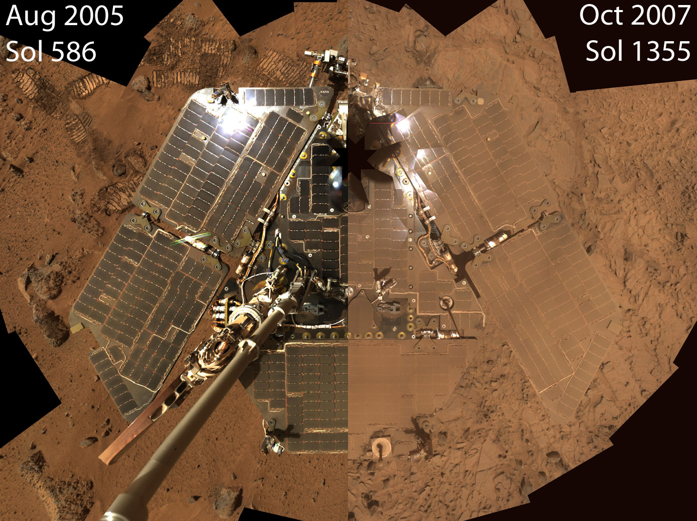 A dusty start to Spirit's winter
This image juxtaposes two "deck pans" captured by the Pancam instrument on Spirit at different times in the mission. On the left is the self-portrait from the top of Husband Hill, when Spirit's deck was nearly as clean as the day the rover landed. On the right, a view taken last month following the summer's dust storm. Dust from the sky has settled on both the rover deck and the surrounding landscape. The dust-covered solar cells will not be able to generate as much power as when they were clean. Unless a gust of wind clears the solar panels, Spirit will have difficulty surviving the approaching Martian winter.
Credit: NASA / JPL-Caltech / Cornell
Although the rover drivers did successfully guide Spirit to its third winter haven this month, they face a huge challenge in the months ahead. It's going to be a long, long winter, what team members are calling a "dark period." By the time the depth of Martian winter hits, in June or July 2008, the "we may only have 30% performance on the arrays," Callas said. "By comparison, for the second Martian winter we had 50-55% performance and on the first we had 70% performance. During the second Martian winter, the rover didn't move for over 200 days. It is likely to be longer this time around, because of the degraded power situation." There is, however, a chance that Spirit could move a little or "bump" at least once while on the slope to allow new targets to be put in the work volume of the robotic arm so it could do science going into and coming out of this "dark period."
Even at the hoped-for 25 to 30-degree tilt, at the depth of Martian winter Spirit will be able to produce just 150 to 160 watt-hours of power, which will leave it "just about power balanced," as Jake Matijevic, of JPL, chief of rover engineering, told The Planetary Society. Chances are, as Matijevic pointed out in the November MER Update, they will probably have to turn off the heater for the Mini-TES to save power.
For now, however, after three weeks of working on Mars time and on weekends, they are, like Spirit, currently enjoying a long-awaited and well-deserved sigh of relief, in addition to the bonus of a weekend off for New Year’s.
Meanwhile, Spirit's discovery of nearly pure silica at Gertrude Weise back in May -- the rover's big find of 2007 and one of the most significant discoveries on the mission -- remains a hot topic conversation among MER science team members. In fact, the scientists are now debating two possible origins for what produced the patch of nearly pure silica (the main ingredient of window glass). It could have come from either a hot-springs environment or a fumarole environment, wherein acidic steam rises through cracks, Squyres announced at the AGU press conference.
 The view south in 3-D
Tantalizing vistas to the south beyond the edge of Home Plate, shown here in 3-D, will have to wait for spring, if Spirit survives until then. Team members have concerns because the rover is approaching its third Martian winter with more dust on its solar panels than it had during its first two winters. The dust lessens the panels' ability to convert sunlight into the electricity that the rover needs for operations and survival. Spirit is headed to the north edge of Home Plate now, where it will position itself on a slope and tilt its solar panels to the north about 25 degrees, facing the Sun to take in as much sunlight as possible. Credit: NASA / JPL-Caltech /Cornell
"This stuff is more than 90 percent silica and there aren't many ways to explain a concentration so high," Squyres said. "We have two hypotheses of what all this silica means. One is that we're seeing hot spring deposits, a siliceous cinder deposit. On Earth, when you have hot water that is generated in a hydrothermal system, it passes through rocks, and in very hot water silica is easily dissolved. So, what will happen is silica will be picked up in the water as it goes through the rock and as it comes up and near the surface, it cools off. All of a sudden that silica is no longer soluble and it drops out of solution and you precipitate very concentrated silica deposits," he explained. "You see these, for example at Yellowstone. The geysers there are surrounded by these things. It turns out, if you look at the spectra of siliceous cinder deposits in geysers and that sort of thing on Earth, it's a dead ringer for what we see of this Martian stuff in our Mini-TES spectra."
The fumarole hypothesis also involves water. "There are places on Earth where, again, water interacts with hot rock and it generates very caustic fluids and steam," Squyres explained. "These are essentially very high-temperature, in some cases boiling, sulfuric acid. This hot vapor or liquid can then propagate through the rocks and it turns out at those very low pH values in the acidic rocks the silica is relatively immobile. But you can dissolve out a lot of other stuff and leave fresh silica deposits behind."
As Squyres views it, the evidence is pointing "most strongly" toward fumarolic conditions, "like you might see in Hawaii and in Iceland," he said, revealing his bias. He favors the fumarole story because the silica-rich soil on Mars has an enhanced level of titanium and on Earth, titanium levels are relatively high in some fumarolic deposits. But, he added, to be fair: "The jury is out. Guys on team are sending email bombs back and forth still arguing."
 Spirit arrives at winter haven
Human explorers would be hard pressed to show more persistence than Spirit. After weeks of careful driving backwards dragging its broken front wheel, the rover finally made it to what team members call Home Plate North. It then gradually descended over the edge to get into position, as shown here, tilting its solar panels 13 degrees toward the sinking winter Sun to maximize its intake of light. Rover drivers plan to continue nudging Spirit to increase the tilt, tracking the Sun as it moves lower in the northern sky. The full-resolution version of this animation can be downloaded here (9.2 MB).
Credit: NASA / JPL-Caltech
Either way, the upshot is pretty much the same. "We're really excited by this," Squyres said. "Whichever of those conditions produced it, this concentration of silica is probably the most significant discovery by Spirit for revealing a habitable niche that existed on Mars in the ancient past. The implications for Martian habitability are one and the same. You can go to hot springs on Earth and fumaroles on Earth and in either place they are teeming with microbial life."
Of course, at this point, we don't know if microbial life took hold on Mars or if they took hold in the environment represented by these silica deposits, Squyres cautioned. "But if either of these hypotheses is correct, then it's a very clear piece of evidence for a formerly habitable environment on the surface of Mars," he said. "This is, in my opinion, the most significant discovery Spirit has made, and it's some 1200 sols into its 90-day mission. It's right up there with sulfate and hematite blueberries over at Meridiani Planum. It took Spirit 1200+ sols to catch up with Opportunity scientifically, but I think we say that's done now."
These high silica deposits would be "wonderful candidates" for sample return, Squyres noted. "If it turns out to be the hot springs hypothesis, one of the wonderful thing about these siliceous cinder deposits is that not only does the hot water provide an environment in which these microbes could thrive, but the precipitation of that silica entombs and preserves them, so you can get wonderfully preserved microfossils in siliceous cinder deposits."
Whether or not these are siliceous cinder deposits has not yet been determined and even if they are they've been sitting around for many billions of years and are "probably not in very good shape," Squyres admitted. As for the capability of fumarolic deposits preserving microbial fossils, "that's something needing more study here on Earth," he said. "Still, if you told me I could go to Mars and pick any one or two rocks we've discovered on this mission that I could put in my pocket and bring home, Innocent Bystander would be near the top of that list."
Opportunity from Meridiani Planum
As 2007 dawned on Opportunity, half way around the planet at Meridiani Planum, it was in the midst of its picture-taking trek around the outer edge of Victoria Crater, the massive crater it pulled up to on Sol 951 (September 27, 2006).
Driving northeast around scalloped rim, the rover stopped along the way at promontories and "alcoves" the MER team named after those Magellan visited on his voyage around the world from 1519 to 1522. It had taken a bit of a break during the winter holidays while en route to the Bay of Toil. The team wanted it to check out an interesting-looking rock they dubbed Santa Catarina, one of many in a dense cobble field in Cabo Anonimo. After all the data was in, Santa Catarina was looking like another meteor.
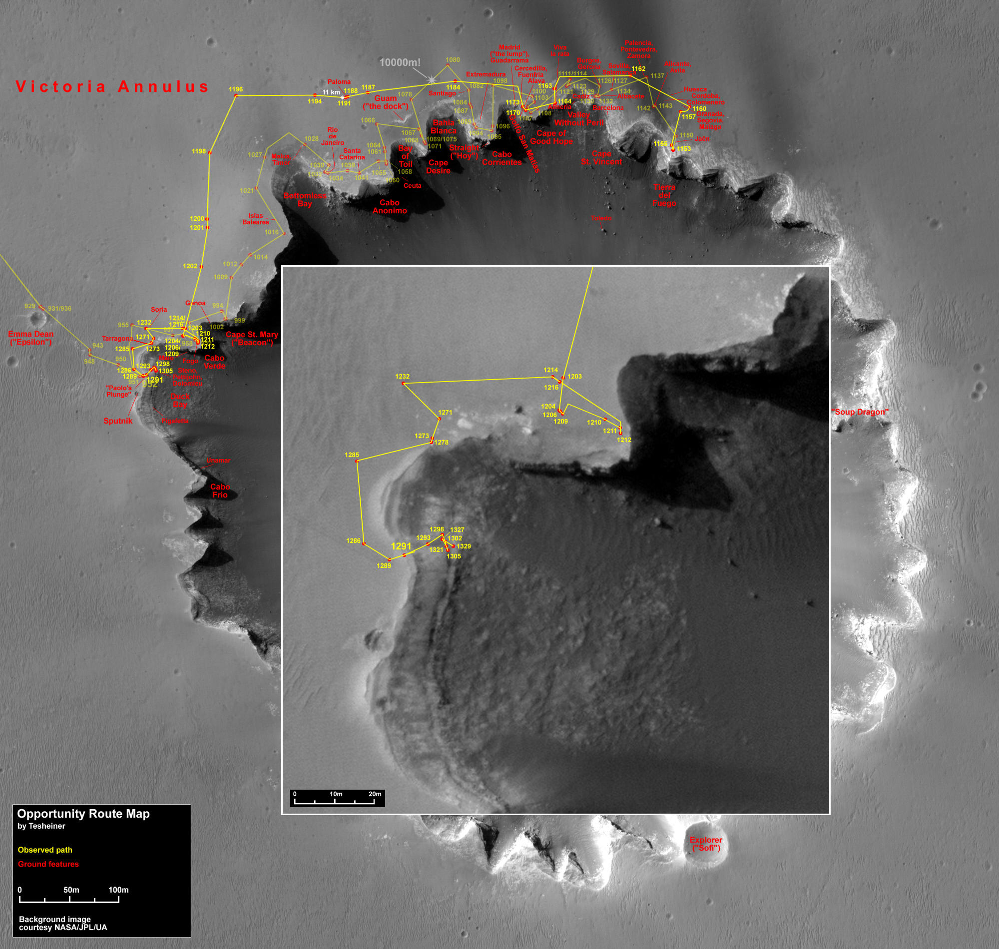 Opportunity's route
This map, which is made from an image taken by the HiRISE camera onboard the Mars Reconnaissance Orbiter, shows Opportunity's route from its arrival at Victoria Crater in 2006 through Sol 1329 (Oct. 19, 2007).Credit: NASA /JPL-Caltech / UAZ / E. Tesheiner
From the Bay of Toil, Opportunity roved on to Cape Desire, then in February, around Bahia Blanca (White Bay) to Cabo Corrientes, a road trip that saw the rover's odometer flip over to 10,000 meters or 10 kilometers, establishing a new rover driving record. Of course, Opportunity has only been breaking its own records for a long, long time now. Nevertheless, this rover likes to drive and it keeping moving on toward Golfo San Matias and then the Cape of Good Hope.
As March blew in, Opportunity left the Cape of Good Hope for the Valley Without Peril, where it took lots of pictures of Cabo Corrientes behind it and Cape St. Vincent, the next promontory to the north and beyond the Cape of Good Hope. The news so many had been waiting for arrived that month as well, when Squyres announced the team had decided the rover would be going into the crater. NASA headquarters had to first approve the plan, but the team was already having the rover begin finishing up its voyage around Victoria's so that it could prepare for what may well be the most truly excellent adventure on its mission.
In April, Opportunity made a final stop at Tierra del Fuego, "the end of the line." There, it ventured into the dark streaks emanating out from the crater onto the plains beyond, visible in orbital photographs. It found them to be sand blown out from the bottom of the crater, as suspected. The rover then headed back to the rim and snapped a set of super high-resolution Pancam images of Cape St. Vincent, which offered up some of the mot impressive crossbedding features the rover had found. It then headed back to Duck Bay, where it first pulled up to the big crater in September 2006. That's where the engineers decided it was safest for the rover to enter.
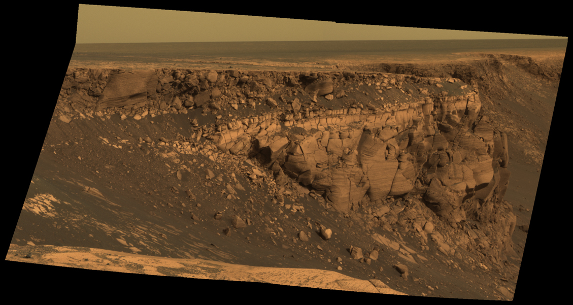 Cape St. Vincent
Opportunity used its panoramic camera (Pancam) to snap this image of the west face of Cape St. Vincent, one of the many promontories that scallop Victoria Crater. The material at the top of the promontory is loose, jumbled rock. A bit farther down into the crater, this abruptly transitions to solid bedrock. This transition point is marked by a bright band of rock visible around the entire crater. Scientists say this bright band represents what used to be the surface of Mars before it was impacted to form Victoria Crater. The rover's investigations may help scientists figure out what kind of environment used to be here long ago.
Credit: NASA / JPL-Caltech / Cornell
During the long drive back to Duck Bay, Opportunity tested new drive software, experienced several gusts of wind that cleared the dust from its solar arrays, and stopped to take one more set of super high-resolution images of more "spectacular stratigraphy," as Squyres put it, at Cape St. Mary.
"You find the bed sets [in Cape St. Mary] are arranged in these very large trough-shaped crossbeds that you [can] see running through [the] images," he told reporters gathered at the AGU press conference. "This is what happens when you have migrating sand dunes…you see these concave upward trough shapes with characteristic scales of meters the sizes of these dunes. It's a very characteristic geometry. That tells you not only that the wind was moving this stuff around, but something about the paleo wind direction, transport direction. We know when we see this geometry that the wind was blowing stuff -- because this is a face that runs east-west -- either north to south or south to north," he explained.
Therefore, Cape St. Mary's straigraphy not only identified the presence of sand dunes in the past, it also hinted as to which direction the winds were blowing. Proving that you don't always need a weatherman to know which way the wind blows, because geologically, there's a way to triangulate the data. In fact, it only took a sample of one more in order for science team members to resolve ambiguity in the paleo wind direction of the past.
Therefore, Cape St. Mary's straigraphy not only identified the presence of sand dunes in the past, it also hinted as to which direction the winds were blowing, proving that you don't always need a weatherman to know which way the wind blows. Geologically, these cross-beds offer scientists a way to triangulate the data. In fact, it only took a sample of one more in order for science team members to resolve ambiguity in the paleo wind direction of the past.
Cape St. Vincent, which is oriented at 90 degrees compared to Cape St. Mary, features what is known as a climbing bed form. "You see the layers are all tilted, sort of marching upward," Squyres pointed out. With these images, the MER scientists determined the actual wind direction. "So at the time these rocks formed, there was a big dune field of sulfate rich sand that was marching across the Martian surface under the influence of a wind that was blowing from the north to the south," Squyres summed up.
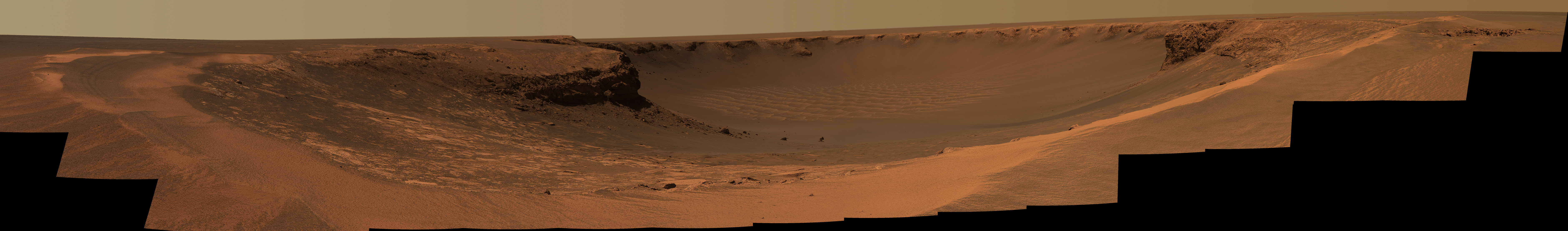 Opportunity Duck Bay panorama
When Opportunity landed at Meridiani Planum in January 2004, Victoria Crater seemed like an unattainable goal. But after a journey spanning 21 months and almost 10 kilometers (6 miles), the rover finally arrived at the huge, half-mile diameter crater in September 2006. It immediately captured spectacular views of steep cliffs cut through 15 meters of Martian bedrock, a new view into the history of a once-water-rich place on Mars. This view into the crater was taken from Duck Bay on Sols 952 and 953. Clicking to enlarge shows the image at half its original resolution; for the full version, visit the Pancam team website. Credit: NASA / JPL / Cornell
On June 28, officials from NASA headquarters announced that it had approved the plan for Opportunity to drive into the big crater. Within hours, the summer global dust storm that began south of Meridiani Planum and soon spread around the planet first stopped Opportunity in its tracks. "We experienced very high atmospheric opacity, the sky was exceedingly dark, and 99.5% of the direct sunlight was blocked out," Callas recounted. Opportunity hunkered down and held on, operating under on a low-power regime, waking only to communicate twice a week or check the atmospheric dust levels. The rover's power levels dropped to 128 watt-hours, the lowest ever on the mission, almost lifeless compared to the robust 700 watt-hours it was sporting before the storm.
Toward the end of August, Opportunity showed its right robot stuff and rebounded to finish the drive to Duck Bay. There, it waited, "wheels practically hanging over the edge," as Squyres put it, to be given the green light to take its first toe-dip inside the crater. By September, wind gusts had cleared enough dust from the rover's solar arrays that its power levels rose to 450 watt-hours, high enough power to return to a full science agenda.
 Dust storm dims Opportunity's Sun
Several times a sol, the rovers take images of the Sun (using a very dark solar filter) to determine the opacity of the atmosphere, a property that is referred to as "tau). Here, images of the Sun were calibrated to show how dim it appeared to the rover during the dust storm. Wherever a circle with an "X" appears, for example, for Sols 1236-1242 (July 16-22, 2007), the skies were so dark the rover could not muster enough power to perform its usual tau measurements.
Credit: NASA / JPL / Cornell / E. Lakdawalla
The JPL engineers, meanwhile, charted Opportunity's path into the crater. "We chose a point that gives us a straight path down, instead of driving cross-slope," said Paolo Bellutta, the rover planner (RP) who plotted the route. On September 11, the rover took its first toe-dip in, just to check the terrain, then roved back out. Everything checked out and the rover had manuevered well on the crater slopes, so two sols later, in it roved, heading for its first target, the unusually textured top layer top layer of the light-toned, triple-layer rock ring that circles the interior.
Opportunity spent most of October focusing on Steno as this layer was called, then moved onto Smith later in the month, a target in the second layer. After a mis-command of the RAT bent the instrument's brush and messed up the initial target, the rover moved to the fresh-faced Smith2 in November. "We put a RAT hole in Steno and measured composition there and we put a RAT hole in Smith, and Smith2, and we'll put a RAT hole in Lyell," the third and darkest layer in the rock ring, Squyres said in the days before Christmas. "Then we'll be able to inter-compare these three layers and try to get some sense of why the stratigraphy looks the way it does."
The team has "a variety of hypotheses for why things look this way," but Squyres declined to further speculate. Other than to note, as he did in November's MER Update, that Steno is one of the most sulfate-rich layers the MER mission seen anywhere on Mars, he resisted “temptation to speculate” on what the rover might see at Lyell. This much, however, is certain: these sulfate-rich layers, which extend several meters below the surface of the regional plain, bear extensive evidence for a wet, acidic past environment and are a small upper fraction of the sulfate-rich layering exposed elsewhere in Meridiani that have been examined from orbit.
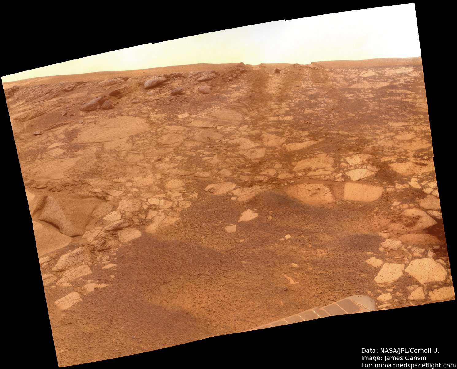 Toward Paolo's Plunge
Opportunity looked backward up the slope of Paolo's Plunge on Sol 1299, to the sand ripple that marks the rim of Victoria Crater. The rover's entry dug two tracks into the sand ripple.
Credit: NASA / JPL-Caltech / Cornell / J.Canvin
"We see evidence from orbit for clay minerals under the layered sulfate materials," said Ray Arvidson, of Washington University in St. Louis, deputy principal investigator for the rovers' science payload. "They indicate less acidic conditions. The big picture appears to be a change from a more open hydrological system, with rainfall, to more arid conditions with groundwater rising to the surface and evaporating, leaving sulfate salts behind."
In December, Opportunity finally moved to Lyell -- the layer, not the crater. Each of the layers in the triple-layered rock ring is named after a renowned geologist: Nicholas Steno (1638-1686), William Smith (1769-1839), Sir Charles Lyell (1797-1875).
A Scotsman, Lyell traded law for geology, and soon proposed that the natural processes operating in the past are the same as those that can be observed operating in the present. He eloquently summarized the concept as: "The present is the key to the past." It stands today as geologic law.
Obviously Lyell is meaningful to geologic studies on other planets and not surprisingly there is also a major crater named after Lyell on Mars and one on the Moon too.
In any event, Opportunity will be spending the New Year's holiday with Lyell and what better company to keep on Mars?
Onward to 2008
As the MER mission heads into 2008 and Spirit and Opportunity prepare to celebrate reaching the rambunctious age of 4, they "are in generally very good health," Callas reported, even if Spirit's energy is expected to drop significantly in the coming months. Although the alpha rover's power levels dropped below 250 watt-hours earlier this month, with its current tilt it, is faring alright. Opportunity, meanwhile, continued to generate abundant solar power levels above 635 watt-hours.
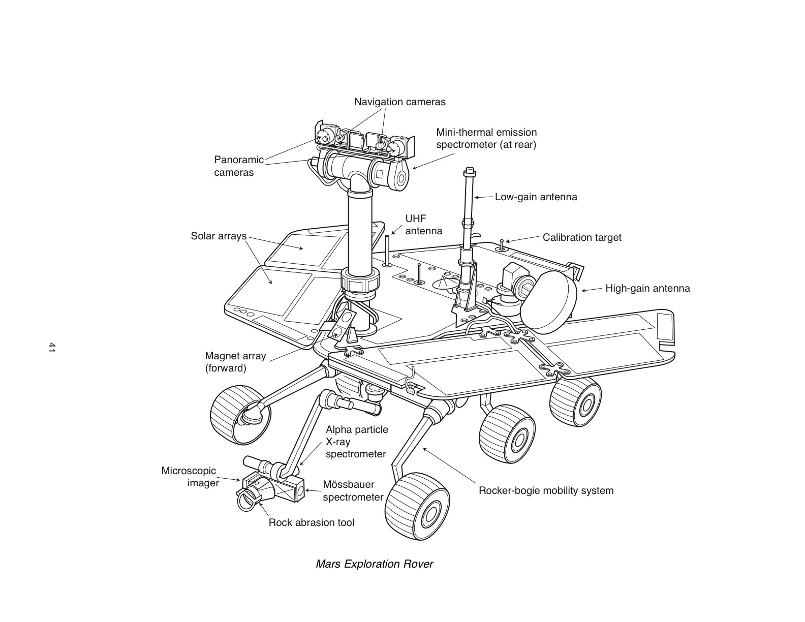 MER
MERThis diagram shows the basic layout of the Mars Exploration Rovers suite of scientific instruments.Credit: NASA /JPL-Caltech / Cornell
"We have had no major failure on rovers since we lost the right front wheel on Spirit almost two years ago. The worst thing that's happened to Opportunity during this time is degradation in one of the joints in the robotic arm, and that too was about two years ago. However, there has been some degradation on the vehicle. Perhaps most significant is on the rock abrasion tool (RAT) on both rovers.”
The RATs on both Spirit and Opportunity have lost their grind encoders that indicate if the motor is spinning, what direction it is spinning and how fast. “We were able to develop workarounds, to figure out a way to reprogram the vehicle to use other information to achieve the same function and to be able to resume grinding,” Callas said. Just a couple of months ago, Opportunity’s RAT also suffered the loss of its revolving encoder.
"This is an indictment, we believe, of the flex cable that goes down the robotic arm," Callas said. "The robotic arm has five joints and there are bundles of cables that have to go through each of those joints and using the arm wears and flexes those cable joints," he explained. "The RAT was really designed to give us two or three grinds on Mars and we now have dozens of grinds on Mars, so we're trying to keep this asset available."
The other affected instrument is the miniature thermal emission spectrometer, better known as the Mini-TES. “It sits in the belly of the rover, but looks up the Pancam mast assembly, almost like a periscope and there is a series of mirrors, folded optics [it uses],” Callas explained. “Our only meaningful theory is that there is a thick layer of dust on one or more of the optical surfaces.”
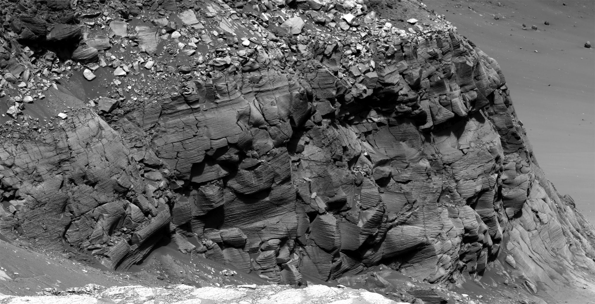 Cape St. Mary
Cape St. Mary, an approximately 15-meter (45-foot) high promontory located along the western rim of Victoria Crater, features some of the most spectacular crossbedding that Opportunity has found since landing on Mars on Jan. 24, 2004. This and other Pancam super-resolution images have enabled scientists to discern that the rocks at Victoria once represented a large dune field that migrated across this region. Opportunity took this image, which is actually formed from a mosaic of images, on Sol 1213 (June 23, 2007).Credit: NASA / JPL-Caltech / Cornell University
The plan to “vibrate” some of the dust off those mirrors, discussed in the November MER Update, is still on. “There's actually a mode we discovered during integration and test of the rovers more than four years ago, where you get a slight instability in the motion control -- the positive feedback hits a resonance. We've actually been able to reproduce that successfully and it doesn't propose a threat to the actuator mechanism, so we're going to try that.”
The MERs are now deep into middle age and the signs of aging have long been expected. Nevertheless, Spirit and Opportunity still have “a tremendous amount of capability in them,” said Callas. “The Martian winter for Spirit is our biggest concern right now. But after that we have an awful lot of exploring we can still do with these vehicles."
Happy New Year. Godspeed Spirit and Opportunity in 2008.
For all the MER Updates, go to: http://www.planetary.org/explore/space-topics/space-missions/mer-updates/
Protect Our Shared Future
You help us defend humanity and prevent asteroid impacts. Donate now to become a Planetary Defender!
Donate