
 Explore Worlds
 Find Life
 Defend Earth


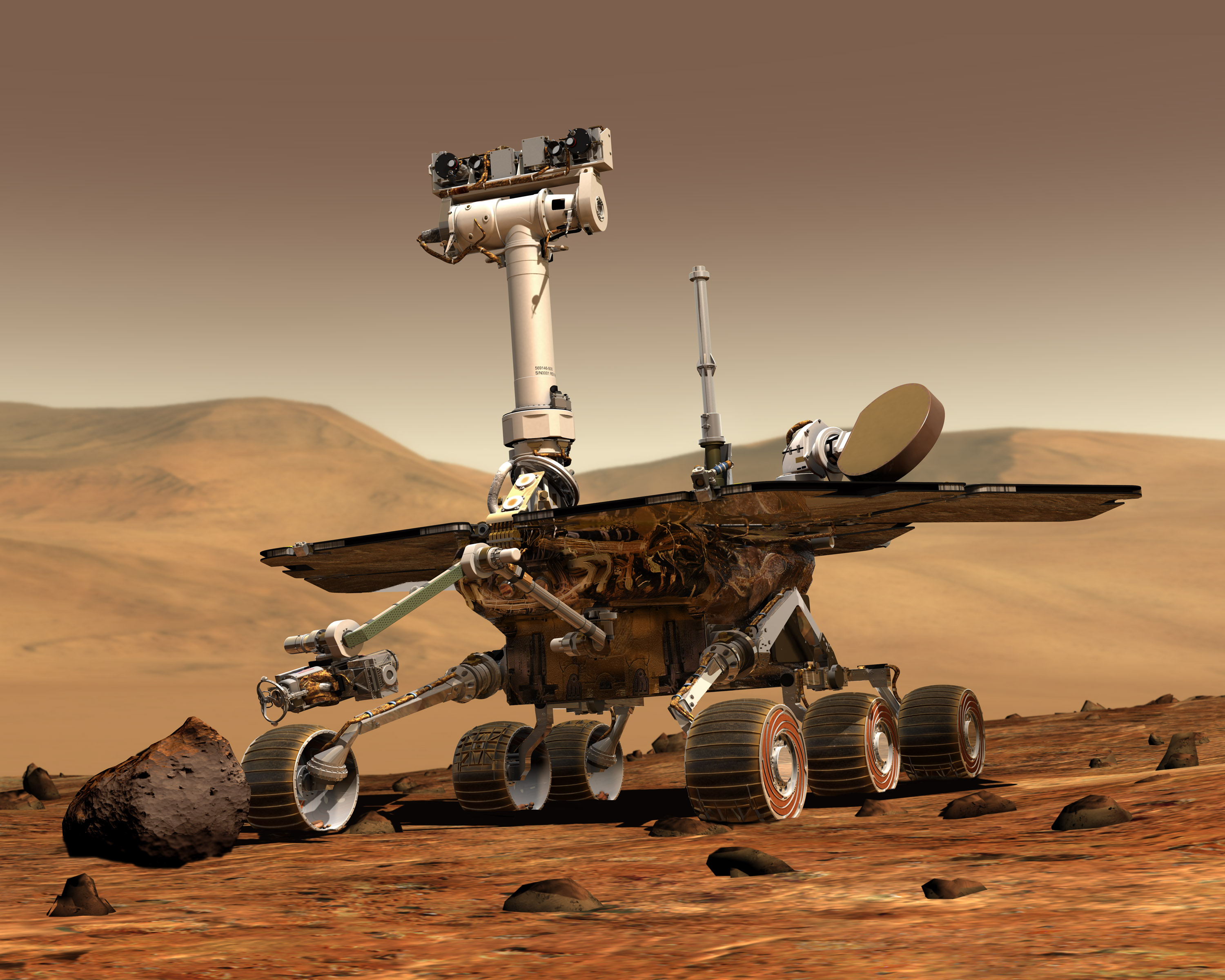
Mars Exploration Rovers Update: Spirit Homes in on Mitcheltree Ridge, Opportunity Crosses Valley Without Peril

Written by
A.J.S. Rayl
Contributing Editor, The Planetary Society
March 31, 2007
It's been business as usual on the Red Planet this month as the Mars Exploration Rovers investigated new areas on their ever-moving missions to explore Gusev Crater and Meridiani Planum. Both Spirit and Opportunity chalked up yet another productive month of field geology as they roved onward in their fourth year on location, checking out more of the local environs some 149,597,900 kilometers (93 million miles) away on Earthlings' favored other planet.
The work completed in March is leading both Spirit and Opportunity to embark on new, textbook-changing adventures and the mission, as those who have been following MER know, is doing anything but slowing down. The twin robot field geologists, which have each exceeded their original 90-day mission by more than 1000 sols, are doing so well that even though their current, fourth mission extension takes them to October, it is entirely probable that the rovers will still be roving strong after that. So this last week, the rovers' principal investigator, Steve Squyres, of Cornell University, dotted the i's and crossed the t's on the proposal for a fifth mission extension, which he sent on to NASA headquarters just a couple of days ago.
NASA generally funds mission extensions based on recommendations from an outside panel of scientists. Of course anything could happen anytime, but if the dynamic duo continue on as they have been, who among any such panel could deny them the right to explore until "death" stops them in their tracks? Odds against odds, MER has become dollar for dollar and discovery for discovery, something of a "miracle" mission to Mars and Spirit and Opportunity have proved to be nothing less than roving robot superheroes.
As March blew in, Spirit was roving into a lot of "neat geology," as Squyres described it. The rover had departed the sulfur-rich patch called Tyrone at the end of February and headed for Home Plate, taking panoramic camera (Pan Cam) pictures of the strange, circular plateau on its approach. Instead of going right onto Home Plate, which team members believe formed from some kind of volcanic process, and beginning a tour of the feature, "the plan evolved," said deputy principal investigator of the rovers, Ray Arvidson, of Washington University, St. Louis. "We went to the north a bit to image Home Plate, then we moved off to Mitcheltree Ridge across from the eastern perimeter of Home Plate," he said in an interview earlier this week.
While at Mitcheltree Ridge, the science team was cleared to use the instrument deployment device (IDD) that had been off-limits since glitching with positioning errors in February. The team took advantage of that and had Spirit place the iron-detecting Mössbauer spectrometer on a large slab of rock called Torquas for an in-depth investigation of its make-up. In the process, the rover stumbled onto what Squyres called a "terrific geologic puzzle." Torquas was loaded with the tiny millimeter-sized spherules that seem just like all those millions of other spherules the rover has been seeing around Meridiani. Unlike all those other spherules, however, these spherules had no hematite. The finding is leading the science team members to believe that perhaps there is no connection between tiny spherules and hematite, a notion that is as intriguing as it is confusing and something that will likely keep some science team members busy for awhile to come. "That's what's been so much fun about this region," said Squyres. "There's just so much neat geology here."

Arriving at Torquas
Spirit took this raw image of Torquas with its front hazzard cam as it arrived at the target on Sol 1141(March 20, 2007. The large slab of rock has presented the MER sicnece team with a "terrific geologic puzzle," said Steve Squyres, principal investigator for the rovers.
Credit: Courtesy NASA / JPL-Caltech
Spirit roved on from Mitcheltree Ridge and closer toward the edge of Home Plate to prepare for its in-depth tour, now slated to begin in early April, according to Arvidson. "We'll go around the perimeter to the south for a while and then pick and choose our way in."
Down on Earth, Spirit's discovery of calcium sulfates in the distinctive white and yellow soils of Tyrone was a topic of conversation at the Lunar and Planetary Science Conference, held mid-month, in Houston, Texas. Calcium sulfate features water (H2O) in its molecular structure, which means water in some form was once this area of Mars. Although two other patches of light-toned soils that Spirit encountered on its exploration of the Columbia Hills contained no signs of calcium sulfates, targets near Home Plate -- including Halley, which the rover investigated at Low Ridge during the winter campaign, for example -- do contain measurable amounts of the mineral. "So we're seeing a correlation between the Tyrone deposits and Halley," said science team member Albert Yen, a geochemist at the Jet Propulsion Laboratory (JPL), where the rovers are being managed. What that means, Yen expounded, is that there's a chemical relationship. "The specific origin is not clearly determined, but there are at least some suggestions that these deposits are ephemeral (or transient) in nature," he said.
On the other side of the planet, Opportunity, meanwhile, has been testing the limits of its driving capabilities, making tracks on its picture-taking cruise around the scalloped rim of Victoria Crater. The rover arrived at the big hole in the ground, which is some 800 meters (half-mile) in diameter, last September and has been "sailing" clockwise, in a northeasterly direction, ever since, stopping at promontories and "alcoves" named for those Magellan visited on his voyage around the world from 1519 to 1522.
 Spirit's dragging wheel digs up bright soil
As Spirit headed eastward toward a hoped-for winter haven on McCool Hill on Sol 788, its wheels stirred up an unusually large quantity of light-toned, white and yellow colored soils in a patch dubbed Tyrone. For the full-resolution image, visit the Planetary Photojournal.
Credit: Courtesy NASA / JPL-Caltech / Cornell
The rover left the Cape of Good Hope at the beginning of March and headed northeast to the Valley Without Peril, where it took images of Cabo Corrientes and Cape St. Vincent, the next promontory beyond the Cape of Good Hope. But Opportunity won't be continuing its clockwise voyage for much longer. In fact, the rover is currently imaging the slopes from the Valley into the crater, and is otherwise in the process of wrapping up this phase of its exploration of Victoria to position itself for one of the mission's greatest assignments.
"We're going in," Squyres announced.
The decision was part of a long-term plan the rover's science team made just last Wednesday (March 28, 2007) in the weekly planning session. Opportunity will finish its current tour of Victoria with a visit to the darkest of dark streaks that can be seen in orbital photographs emanating from the Valley Without Peril, and a visit to one more promontory, Tierra del Fuego, just northeast of Cape St. Vincent. Then, it may -- or may not – depending on what the images of the Valley Without Peril's slopes reveal -- take a "toe-dip" into the crater from the Valley for some quick imaging. In any event, Squyres said, the rover will then "scoot back" to Duck Bay and "get on with exploring the interior" of the grand Victoria – if that is, the plan passes a careful safety review.
Spirit and Opportunity remain in good health and are both, obviously, going strong, though both are showing, however slowly, inevitable signs of aging.
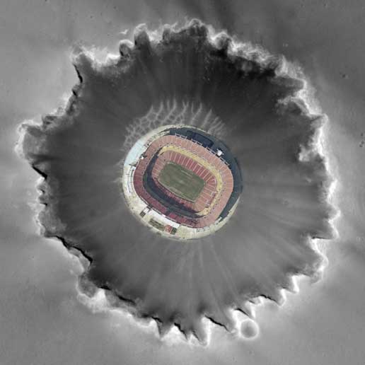 Bigger than a football field
This photo composite shows an aerial view of FedEx Field in Landover, Md., home of the Washington Redskins, superimposed on Mars' Victoria Crater to give a sense of the crater's scale.Credit: Courtesy FedEx Field; Screenshot (c)Google Inc.
Like always, Spirit continues to be the most challenged of the twins, but the rover and its handlers are as creative and resilient as ever. "The team has learned how to drive Spirit very well with just five wheels," offered John Callas, rover project manager at JPL. And, although Spirit is taking on more dust than its twin, so far its energy is good and getting better.
"The energy levels for Spirit are running just over 400 watt-hours lately, reported JPL's Bruce Banerdt, MER project scientist. "The power is still going up because of the season. We're going from spring into summer when we're going to get the best solar insulation on the panels. At the same time, the dust level is increasing. Right now, the Sun is outpacing the dust accumulation so everything's good."
It's about the same time of year on Mars now, though, as it was when winds blew dust off Spirit and its solar panels in 2005. "But we can't bet on that," said Yen. "We saw a couple events over the last 1000 sols, so you have to be pretty lucky to have that happen. But we are clearly in good shape for the Martian summer."
Opportunity, meanwhile, has been boasting power levels in the "high 500s," said Squyres, "and so it is doing fine." To its good fortune, this rover is "just not as dusty as Spirit and not as dusty as we would have predicted it would have been from steady state accumulation," Banerdt added. "Some of the dust is getting removed from Opportunity occasionally and it's just in a better position than Spirit in terms of latitude this time of year."
Just as Spirit regained use of its IDD, it looks like Opportunity regained use this month of it rock abrasion tool (RAT), which suffered a positioning failure in January. Now that those two instruments are back in action, all the instruments on each rover are functioning. For these highly sophisticated, intricate, temperature-battered electronics, that is almost beyond remarkable by anyone's account.
Spirit From Gusev Crater
 Home Plate
This image from the Mars Reconnaissance Orbiter's High Resolution Imaging Science Experiment (HiRISE)camera shows the area in the Inner Basin of the Columbia Hills that Spirit is currently roving around.
Credit: Courtesy NASA / JPL / Cornell
Spirit roved into March healthy, though still unable to use its robotic arm or IDD until more diagnostic tests could be done. Instead, it focused its efforts on remote sensing as it departed Tyrone (adjacent) for a point just to the north of Home Plate in the Columbia Hills of Gusev Crater.
Meanwhile, one of the white and yellow sulfur-rich soil targets at Spirit's latest inspection of Tyrone (adjacent) -- Mt. Darwin -- turned up calcium sulfates and that churned up a lot of intrigue among team members and a lot of talk at the Lunar and Planetary Science Conference (LPSC), held March 12-16 in Houston. The water (H2O) bound into the mineral had something to say about the past environment there.
"This material could have been left behind by water that dissolved these minerals underground, then came to the surface and evaporated, or it could be a volcanic deposit formed around ancient gas vents," Arvidson said, offering up the team's two working hypotheses. Determining which hypothesis is correct would give Mars scientists a better understanding of the environmental history of the Columbia Hills region that Spirit has been exploring since 2004, which, after all, is the Big Picture scientific goal for this rover.
Spirit's discovery of the distinctive materials at Tyrone was actually an accident. The soils had been hidden under a layer of normal-looking soil until the rover's wheels churned it up while it was struggling to cross the patch of the unexpectedly soft soil nearly a year ago. To recap: The rover's right front wheel had stopped working a week earlier and controllers at JPL were trying to maneuver the rover backwards, dragging that wheel. Because of the difficulty crossing Tyrone and because winter was fast approaching, the MER team had opted out of the original plan -- scaling part way up McCool Hill -- and chose to direct Spirit to a smaller, more accessible slope for the winter, a place dubbed Low Ridge. That's where the rover hunkered down for winter, spending nearly seven months in one parked position, so it could keep its solar arrays tilted just so for maximum sunlight exposure.
In its struggle to leave Tyrone, Spirit collected some of the strange soil in its right front wheel well and dragged it to Low Ridge. During the long Martian winter, the rover spent some time studying the composition and mineralogy of the soil it had inadvertently brought along. The rover also examined Tyrone from a distance during that period, using an infrared spectrometer -- the mini-thermal emission spectrometer (Mini-TES) -- to determine its mineral make-up. The instrument found the soils to be sulfate salts associated with iron and calcium, which has H2O bound in the chemical structure. "These salts could have been concentrated by hydrothermal liquid or vapor moving through the local rocks," suggested Yen.
 McMurdo pan labeled
During the last Martian winter, Spirit sojourned in Low Ridge, its winter haven, where the robotic geologist hunkered down from late April 2006 into November 2006 parked on a north-facing slope in order to keep its solar panels pointed toward the Sun for maxium sunlight. During that time, while the rover spent the daylight hours conducting as much scientific research as possible, science team members assigned informal names to rock outcrops, boulders, and patches of soil commemorating exploration sites in Antarctica and the southernmost islands of South America. Antarctic bases are places where researchers, like the rovers on Mars, hunker down for the winter in subzero temperatures. During the past Martian winter, Spirit endured temperatures lower than -100 degrees Celsius (-148 degrees Fahrenheit. This full-color mosaic of images -- taken from the mission's largest panorama,the McMurdo pan -- was acquired by the rover with the Pancam. It shows the various features of the landscape at Low Ridge and the informal names used to identify them. Spirit is currently back at Home Plate.
Credit: Courtesy NASA/JPL-Caltech/Cornell
Interestingly, two other patches of bright soil that Spirit uncovered before Tyrone -- Paso Robles, by the north side of Larry's Outcrop, and Arad, from the Dead Sea area on the south side of Husband Hill -- were also sulfur-rich, but neither showed evidence of calcium. Rather, each had similarities to local rock compositions that were different at the three sites, something that suggests localized origins.
Spirit resumed driving in November 2006 when the Martian spring brought enough daily sunshine to the solar panels to give it the necessary energy, and the rover headed, according to plan, back to Home Plate by way -- a safe way -- of Tyrone.
"One of the interesting features of these light-toned deposits is that they really contain the geochemical signatures of the nearby rocks," said Yen. "The Tyrone deposit, which we didn't want to go back into for fear of getting stuck, did allow us to measure the material that was dragged out by the wheels and the closest one to Tyrone -- Mt. Darwin -- has clear evidence of calcium sulfate, something we did not obviously detect in Paso Robles or Arad. Yen suggests that these minerals formed as a result of volcanic processes. "Given the likely quantity of volcanic-related processes in this area," he said, "calcium sulfate as a potential aqueous precipitator from volcanic processes cannot be ruled out."
Spirit will watch for more patches of bright soil. "If we find them along fractures, that would suggest they were deposited at ancient gas vents," Arvidson noted. "If they are at the saddles between hills, that would suggest the deposits formed where groundwater came to the surface."
 Home Plate up close
Spirit took this raw image of Home Plate on Sol 1123 (March 1, 2007) with its Pancam.Credit: NASA / JPL-Caltech / Cornell
Throughout March, Spirit, juggled its various field geology assignments with the routine atmospheric studies -- monitoring dust levels with the Pancam, surveying the sky and ground with the Mini-TES, searching for clouds with the navigation camera, while occasionally monitoring dust on its mast. The rover devoted first day of the month, Sol 1123, taking Pancam images of Home Plate, surveying a target known as Madeline English with the Mini-TES, then driving 7.95 meters (26.1 feet) toward Home Plate. After the drive, it took the usual post-drive images with the navigation camera.
Spirit is investigating the area around Home Plate now to confirm the science team's contention that explosive volcanism, driven by the interaction of magma with water, formed the strange, circular plateau and other similar features nearby. In fact, word is that the hypotheses on the origin of Home Plate will be discussed by the MER science team in a paper to be published sometime in the not too distant future.
After acquiring Pancam images of the dune field El Dorado on Sol1126 (March 4, 2007), Spirit drove 3.5 meters closer to Home Plate, acquiring the usual post-drive images with the front and rear hazard avoidance cameras and navigation camera. The next sol, the rover looked for Martian dust devils with the navigation camera, took more images with the front hazard avoidance camera, and devoted some time to testing the switch on the contact plate of the Mössbauer spectrometer by touching the filter magnet with the instrument. The Mössbauer was the instrument that had a couple of failed placements when the IDD was pulled off-line.
"We retraced our steps, our path from Tyrone back to the point where we left Home Plate last year," said Banerdt. "If you remember, we were coming around Home Plate clockwise and came around the western edge and did a sort of 90-degree turn and headed towards McCool Hill. We retraced our path back to roughly the same point we left on Home Plate."
 Testing the Mössbauer
Spirit took this raw image of its test placing the Mössbauer spectrometer with the instrument deployment device (IDD)on Sol 1132 (March 10, 2007. Faults occurred when the rover tried to place the instrument on targets last month, so the IDD was taken out of use until engineers determined it was safe to use it again.
Credit: NASA / JPL-Caltech
Instead of turning south and continuing around Home Plate, as had been discussed, "the plan evolved," said Arvidson. The science team decided that Spirit would jog north just enough to take more Pancam pictures to fill in the "holes" in the imagery it took at that edge of circular plateau last year. It had been unable to complete the task, because it had to get to Low Ridge where it could safely wait out the brutal Martian winter.
From there, Spirit roved toward the eastern perimeter of Home Plate. "We already went past the eastern side last year, but we were in such a hurry we didn't have time to stop and do the high-resolution Pancam coverage of the scarp there, which is fairly low on this side, not like the west side where you have a fairly high exposure," said Banerdt. "Because it's low, it's more accessible in a lot of ways and we got up really close and took a lot of images and did some Mini-TES too."
During the ensuing sols, the rover conducted more remote sensing, including taking a mosaic of Home Plate and a survey of rock clasts with the Pancam, and studying the mineralogical content in targets named after female baseball stars of the past -- Irene Hickson, Joanne Winter, Bette Trezza, and Carolyn Morris, then Anna Mae Hutchison, Faye Dancer, Dorothy Hunter, and Velma Abbott -- keeping in line with the theme of naming the targets around Home Plate after famous baseball players. [The first targets were christened with the names of the stars from the Negro Leagues.]
With its IDD still being diagnosed, Spirit began the second week in March by taking more Pancam images of Home Plate and the vesicular basalt rock target called Joanne Winter. With the Mini-TES it investigated the mineral make-up of more vesicular basalt rocks named after Fredda Acker, Jean Gilchrist, Betty Warfel, Evelyn Adams, Bethany Goldsmith, Betty Whiting, and Melba Alspaugh. The rover also took more pictures, acquired a high Sun survey, and made two "movies" in search of dust devils with the Pancam.
Once Spirit completed those assignments, the MER team decided to take advantage of the opportunity to do some work at Mitcheltree Ridge, which parallels the eastern side of Home Plate and lies across a sort of little valley about 20 meters (65 feet) away. "There's always been a desire to analyze some of the material around Mitcheltree Ridge, but having a bunch of scientists come together to try and decide which way to go is like a random walk sometimes," said Yen. "People decide they want to go one way and then a discovery makes it more interesting to go someplace else. If we had gone directly to Home Plate, the chance we would return back on the eastern aide are pretty unlikely and there are some team members who wanted to look at vesicular basalts [rocks] on top of Mitcheltree Ridge, because they have interesting morphology and because the vesicularity of the basalts can help constrain the nature of the volcanic processes that might have been involved in the region," he explained. "These types of basalts are found elsewhere, but Mitcheltree Ridge seems to have a large population of them and we see some exposed layering there. We want to figure out the connection to Home Plate."
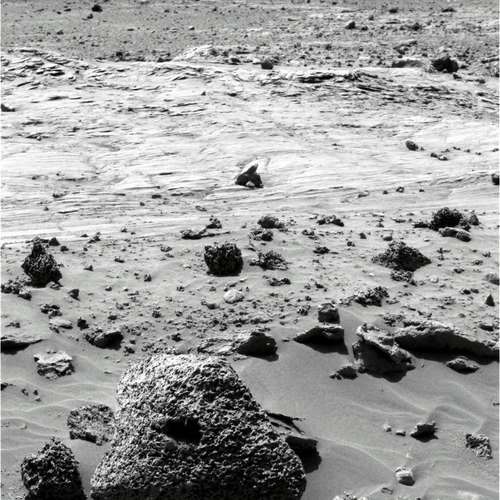
 Torquas
Spirit took this image of Torquas with its Pancam on Sol 1143 (March 22, 2007). Although Torquas feature many of the tiny 1-1.5 millimeter spherules seen throughout the mission, these spherules lack hematite -- and that, said Steve Squyres, "is real interesting."Credit: NASA / JPL-Caltech / Cornell
On Sol 1132 (March 10, 2007), Spirit conducted more tests with its IDD, touching a soil target with the Mössbauer spectrometer and acquiring microscopic images. Everything seemed to work just fine. The rover then reexamined the vesicular basalt known as Faye Dancer with its Mini-TES, packed it up, and drove 10.2 meters (33.5 feet). When it stopped, the rover took the images needed for a 360-degree mosaic with the navigation camera of that vantage point in the "valley" between Mitcheltree Ridge and Home Plate.
Since Mitcheltree Ridge and Home Plate are only about 20 meters (about 65 feet) apart and because the Mini-TES points from the Pancam mast, Spirit can turn the instrument around in virtually any direction while it remains stationary. Throughout the middle of the month, the rover used that capability of the mineral detecting device to check out Mitcheltree Ridge targets known as Lothar, Manator, Morbus, Ombra, Otz Valley, and Pankor, each named for a place in the Barsoom series by Edgar Rice Burroughs, and then turned to image other targets near Home Plate and elsewhere in the vicinity.
The rover also spent some time during the middle of the month pointing the navigation camera at the surrounding terrain to make a "movie" in search of dust devils, and acquiring full-color images of a nearby "knob," christened Pitchers Mound, with the Pancam. The science team initially thought Pitcher's Mound might be another possible outlier of Home Plate, but the preliminary analyses indicates it's different than Home Plate material, according to Banerdt. Spirit also used the Pancam to take pictures of an outcrop known as Backstop, conduct another survey of rock clasts, and then turned again to the Mini-TES to collect mineralogical data on targets named after Shirley Jameson, Connie Wisniewski, Margaret Stephani near Home Plate, as well as targets known as Tjanath, Phundahl, and Panar in the Mitcheltree Ridge area.
On Sol 1135 (March 13, 2007) Spirit drove 11.06 meters (36.29 feet) following Mitcheltree Ridge toward a rock target on which it could use its IDD. An outcrop section dubbed Outlier 2 had originally been the IDD target, but given that Spirit's right front wheel is not healthy, RPs thought that getting to Outlier 2 would be "a bit of a challenge" and so the team chose a large slab they called Torquas to be "the representative target from Mitcheltree Ridge to analyze in detail," said Yen. As the rover approached the newly-chosen target, it surveyed other targets in the area called Ptarth, Thark, as well as examined scattered light and searched for dust devils with the navigation camera
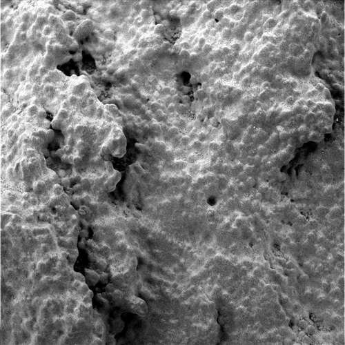 Torquas up close
Spirit examined Torquas up close with its microscopic imager (MI)once the science team was cleared to use the instrument deployment device (IDD). The rover's robotic arm had been put off-limits until engineers could figure out why it twice misplaced the Mössbauer earlier this year. The timing couldn't have been better. The rover uncovered yet another Martian mystery in the spherules on the large slab of rock.
Credit: NASA / JPL - Caltech
Spirit got an unexpected "easy" day as the third week of March began. After acquiring thumbnail images of the sky with its Pancam and a "movie" in search of dust devils with the navigation camera on Sol 1137 (March 15, 2007), the rover waited for the next day's instructions, but it was unable to establish a link with Earth because the Mars Reconnaissance Orbiter (MRO) had gone into safe mode. Both the rover and the orbiter share the same X-band frequency with Earth and therefore must coordinate communications.
Instead of standing down and doing nothing, the rover executed "runout" science activities for the first time in 321 sols, monitoring atmospheric dust, measuring light looking east and west, imaging the calibration target, and taking thumbnail images of the sky. Ultimately, Spirit wound up sending its data to Earth while MRO was on the other side of Mars, out of reach of Earth. Despite the somewhat crowded conditions at Mars these days, from a tactical planning perspective, "things have been pretty smooth," reported Yen. "The Deep Space Network (DSN) guys have been good at getting us our uplinks with the MRO situation."
In addition to its routine atmospheric studies that week, Spirit conducted an argon experiment using the alpha-particle X-ray spectrometer (APXS) and conducted more remote sensing, homing in on Mitcheltree Ridge targets dubbed Ompt, Shador, Zor, and Zodanga with the Pan Cam and Mini-TES, then acquiring hazard avoidance camera images and navigation camera images of potential scientific targets, as well as a 360-degree view of its surroundings using the navigation camera. On Sol 1140 (March 19, 2007), the rover took snapshots of the sky using the Pancam and made another dust devil "movie" with the navigation camera.
With the diagnostics on the IDD revealing no hint of why the faults occurred when the rover tried to place the Mössbauer last month and the instrument checking out in fine form during the tests, Spirit's IDD was cleared for use. "They're thinking maybe it was just an unusually-shaped target or something like that or there was something about the imagery they were using that gave them enough of an error that it didn't quite touch when they expected it to," said Banerdt. "The rovers are really complex machines, with a lot of mechanical software and electrical things and when everything's playing together you can't always track down what's happened. That's just going to happen when you've got as complex a system as we're working with. We try to simulate everything we can but you don't always get everything."
Bottom line: "The IDD is fine," said Squyres. "There never was anything wrong with it. There were 2 or 3 unlucky placements in a row where we didn’t quite make the contact with the Mössbauer and we spent a lot of time checking it out carefully and everything was fine. You do this for 1100 and some odd sols sooner or later you're going to have an unlucky patch and that's what happened," he concluded. "We are taking a couple extra precautions and have made a couple changes in how we sequence those movements," added Yen.
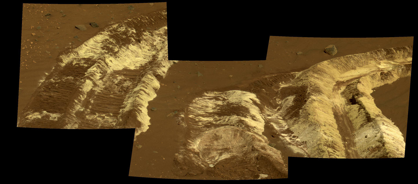
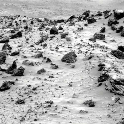 Vesicular basalts on Mitcheltree Ridge
This raw image of the vesicular basalts on Mitcheltree Ridge was taken by Spirit with its Pancam on Sol 1146 (March 25, 2007).Credit: NASA / JPL-Caltech / Cornell
Torquas turned out to be a "nice, dust-free target," said Yen, and Mini-TES' look suggests it [resembles] the upper unit of Home Plate that we analyzed probably around Sol 750 or so – a year ago," he added. "While Mini-TES thought it looked like Home Plate, it's good to get a ground truth. So, we went over and put the Mössbauer spectrometer on it and there are similarities, but there are differences as well. That's what's interesting about this place – it's really kind of confusing. There are a lot of trace elements and a lot of compositional signatures in iron mineralogy that vary from place to place and we're trying to understand why that is and understand it's relationship to the formation of Home Plate."
The little "valley" between Mitcheltree Ridge and Home Plate in fact became a scientific focal point before the rover headed back Home. "There's not much separation between the two, but it's not clear whether this little valley in between is something that's been eroded out of a once continuous set of layers that stretched from Home Plate to Mitcheltree Ridge or whether Mitcheltree Ridge is part of material below Home Plate that is dipping upward and so maybe stratigraphically it's lower than the Home Plate deposits," said Banerdt. "We wanted to do a fairly complete Mini-TES survey of Mitcheltree Ridge materials and at least one or two IDD analyses." That, actually, is what Spirit was up to for much of the past week.
"The geology in this little valley between Mitcheltree Ridge and Home Plate turns out to be one of the neatest little bits of field geology we've done on the whole mission," said Squyres. "It's got this complicated stratigraphy. It's not so complex we can't figure out, but it's a real good challenging geologic puzzle. The team is doing geologic crossections and maps and stratigraphic sections, real hardcore field geology. I don't think Spirit has done geology this interesting, this rich, with this variety, since back at Larry's Lookout," he said.
"We've had some really interesting puzzles that have popped up and gradually we've been able to look at things and start piecing things together," Squyres continued. The biggest puzzle involves those little spherules. "At two different locations we found 1 to 1.5 millimeter those little spherules -- remember the microscopic imager (MI) pictures of King George Island and Riquelme? In both instances, those things were chalk full of hematite. But at Torquas, even though it's got little round spherules, there's no hematite. These things are nothing like blueberries" [the spherules first found early in the mission that seemed to be hematite–loaded]. Torquas has no hematite. That's real interesting. We suspected this already--" Squyres said, pausing. "The little round spherules have nothing to do with hematite. The hematite is a separate problem."
A separate problem?
 At the edge of Home Plate
Spirit took this image from the edge of Home Plate with its front hazard camera onm Sol 1150 (March 29, 2007) Credit: NASA / JPL-Caltech
"There are spherules with hematite and spherules without hematite and there's fine-grained outcrop with hematite and fine-grained outcrops that don't have hematite -- the point is there is no correlation at all between spherules and hematite," Squyres said. "We just discovered this" [Wednesday]. "It's an interesting puzzle. This is speculation on my part, but these rocks have a lot of magnetite in them and if you oxidize magnetite you can form hematite that way. So this stuff might have formed locally as a result of high-temperature oxidation of magnetite. Neat stuff. But this is speculation. We've got a terrific geologic puzzle here, and we're getting new pieces of the puzzle every day now."
In order to put together the geologic and environmental history of the Inner Basin and the Columbia Hills, the science team needs to find and understand all the correlations between these various outcrops to understand their relationship both chemically and stratigraphically. "We want to understand the origin of the Home Plate feature and get to exposed layers that we have not seen before, and we want to get on top and go around," said Yen. "This is discovery-driven science. When we see something different, we adjust your investigations accordingly. So, while we have a longer-term strategy of investigating Home Plate, as we learn more we can get diverted to things of interest that are relevant to our goal."
On Sol 1149 (March 28, 2007), Spirit started driving south again and east to a position up against the edge of Home Plate again. "We're going to head southward again to look at some particularly good outcrops of some materials that look like they may be very diagnostic of the stratigraphic section," said Banerdt. "In fact, there have been several layers tentatively identified in terms of the lower most layers and some upper layers that look like they may be compositionally distinct. We want to do an analysis on those and try to tie it to other places we've looked at. You have this white stack that’s obviously Home Plate, then there are some rocks inboard of that that look like they are outcropping, which may have something to do with material underlying Home Plate, so we have three different kinds of rocks in the same spot, all of which we can get to very easily. The relationship between those three may help us to tie that stratigraphy to what we saw at Troll and Torquas and some of the other places that we've analyzed," he added.
"We are right on the east edge of Home Plate right now," Squyres confirmed on Thursday (Sol 1130). Although the plan to go south holds, getting on top of Home Plate is a fait accompli. "We've already found at this location one viable route up Home Plate so if everything else doesn't pan out, we already have a place where we can get up on Home from where we're at right now."
First, the science team has other work its wants Spirit to accomplish on the margin of Home Plate. "The intention now," Squyres said, "is to back down from current location, work clockwise around the edge of Home Plate, hitting a couple of outcrops along the way, then try to get up on Home Plate somewhere along its southern margin."
Opportunity from Meridiani Planum
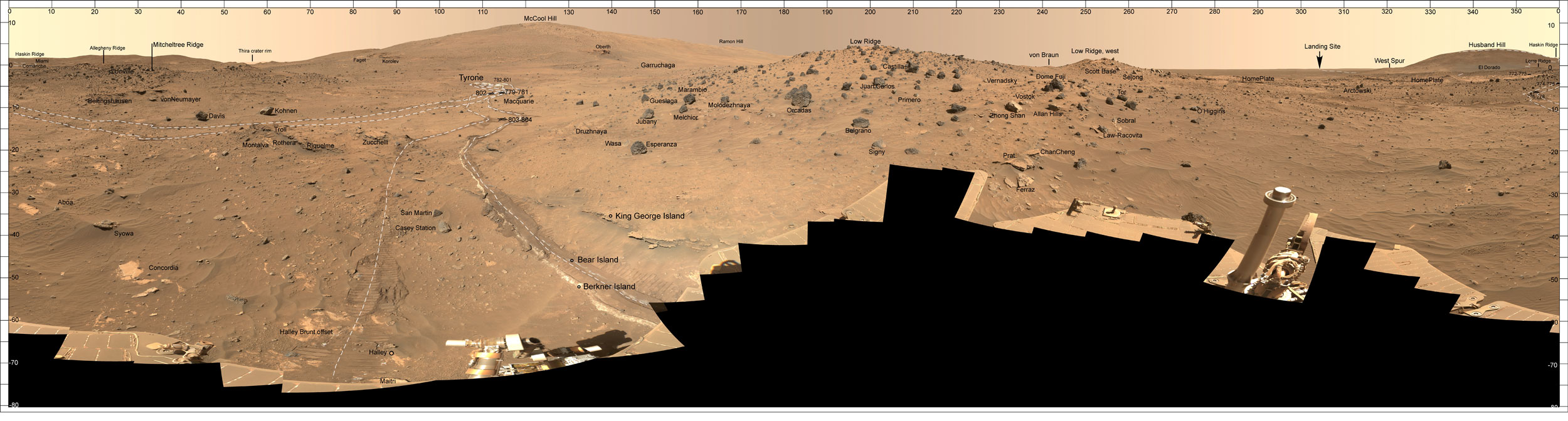
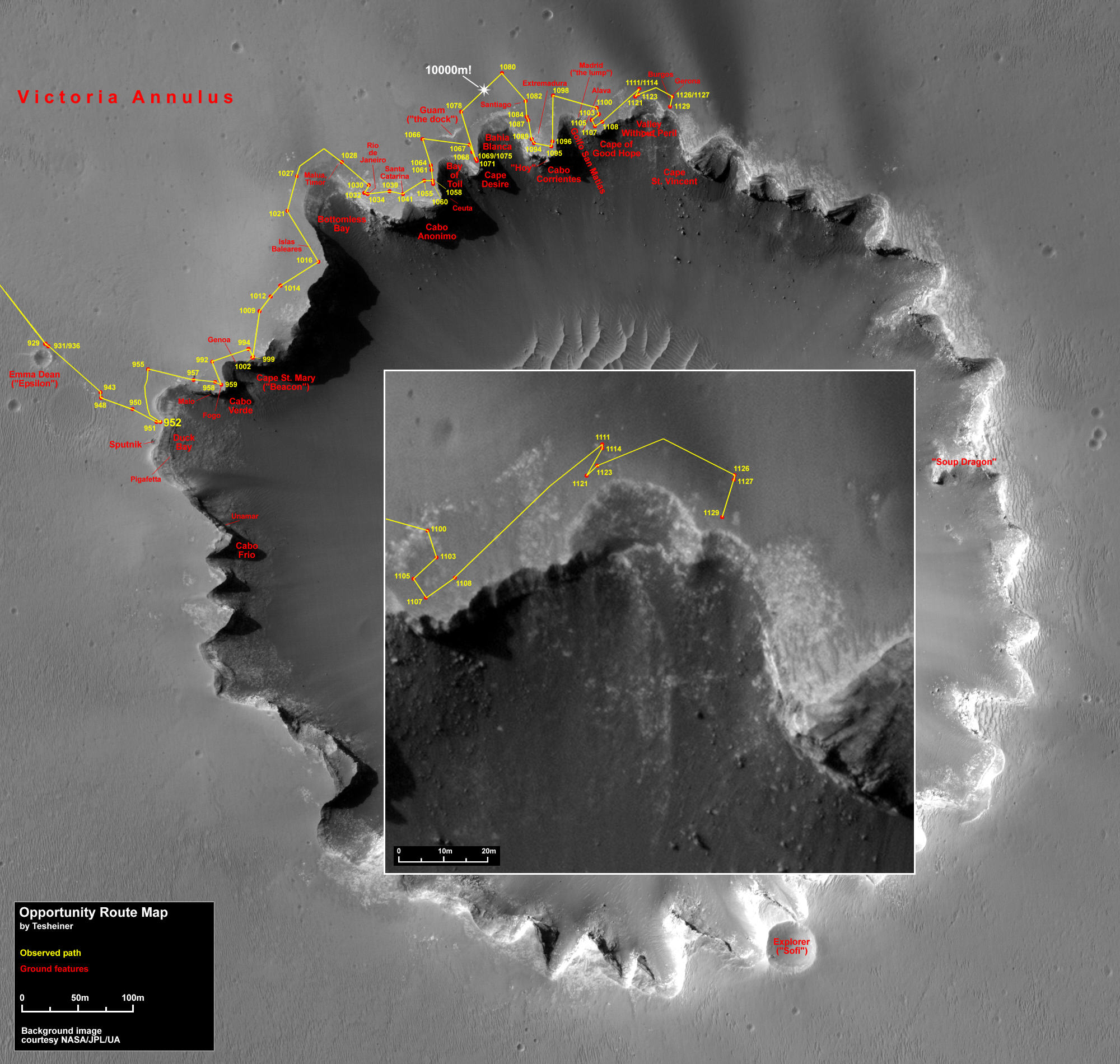 Opportunity route map to Sol 1129
As of Sol 1129 (March 29, 2007), Opportunity stood on the rim of Victoria crater between the Cape of Good Hope and Cape St. Vincent looking into the Valley Without Peril.Credit: NASA / JPL / U. Arizona / Eduardo Tesheiner
Opportunity cruised into March on the road, continuing its clockwise, picture-taking voyage around the scalloped rim of Victoria crater, imaging the cliff-like promontories that alternate with more gradually sloped "alcoves." The rover is taking color pictures in stereo with the Pancam at each of the promontories and the "alcoves" in between as it roves along. When they're all processed and put together, scientists, engineers, and software specialists will be able to create a three-dimensional virtual Victoria Crater that promises to be spectacular to look at as well as study.
As the calendar page turned to March, Opportunity was atop the Cape of Good Hope in the midst of snapping pictures. It spent the first week of the month focused on Cabo Corrientes. On Sol 1105 (March 4, 2007), Opportunity drove 8 meters (26 feet) southwest toward the edge of the Cape of Good Hope, where it took the first half of the stereo Pancam image of Cabo Corrientes across Golfo (Gulf) San Matias. The rover drove another 4 meters (13 feet) south-southwest on Sol 1107 (March 6, 2007) to take the second half of the stereo image of Cabo Corrientes. Opportunity wasted no time this month. On the following sol, 1108, the rover drove 8 meters (26 feet) toward the Valley Without Peril, taking the usual post-drive images upon its arrival.
Like Spirit, Opportunity continued conducting all the requisite daily atmospheric observations -- a Pancam tau measurement, Mini-TES survey of the sky and ground, a search for clouds with the navigation camera, and occasional Pancam mast assembly dust monitoring -- and also performed several alpha particle X-ray spectrometer (APXS) integrations on the Martian atmosphere, as part of the long-term monitoring of the density of argon and how the argon-carbon dioxide mixing ratio changes as the polar caps acquire and sublimate carbon dioxide.
A rock abrasion tool (RAT) grind test was the first thing on Opportunity's agenda on Sol 1109 (March 8, 2007) as the second week of March began. The RAT test was to see if the Coke-can sized instrument was positioning its grinder properly. In January, the RAT failed on two occasions to make the proper placement. Designer-engineers from the maker, HoneyBee Robotics, and JPL engineers worked together for weeks analyzing what happened. It turned out the instrument's decoder failed. Since that was something on which the RAT relied to make its placements, the HoneyBee Robotics team set about figuring out a workaround. The rover filled out the sol by taking a full-color Pancam image of the foreground, which it then assessed with the Mini-TES, and collecting the images needed for a mosaic of its own tracks with the navigation camera.
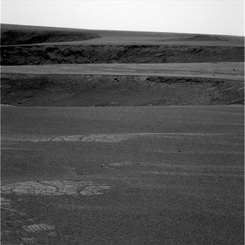 The long and winding road around Victoria
The rim of Victoria Crater looks almost as smooth as blacktop in some places, but the driving isn't as easy as it would seem. That's because the rover is driving along the scalloped edge of a really big cliff, which can be seen in this image that Opportunity took in mid-March.
Credit: NASA / JPL-Caltech / Cornell
Opportunity drove 40 meters (131 feet) northeast on Sol 1111 (March 10, 2007), to the mouth of the Valley Without Peril to position itself for an extensive stereo image of Cape St. Vincent, the next promontory to the northeast of the Cape of Good Hope. The following sol, the rover performed another test with its RAT. This test indicated the need to circumvent a portion of the flight software that was still trying to use the RAT’s failed encoder. A "patch" was slated to be up-linked and tested the coming weekend. The rover spent the rest of Sol 1112 conducting a high Sun observation, taking full-color pictures of the foreground and thumbnail images of the sky with the Pancam, taking images with the navigation camera to prepare for Mini-TES observations of the same areas, and looking for argon with the APXS.
On Sol 1114 (March 13, 2007), Opportunity attempted an 8-meter (26 feet) drive south-southwest to a position on the west bank of the Valley Without Peril in order to image Cape St. Vincent to the east, but stopped after only a half a meter of progress because the rover failed to stay within limits placed on its heading by the rover drivers. "It's driving in extremely difficult terrain – that's the problem," Squyres said. "The images are deceptive, because it looks like it ought to be really easy, but this is actually some of the toughest driving we've ever faced."
The reason is that the rover is driving along the top of a very tall cliff. "And if we fall off the cliff we die," Squyres bluntly pointed out. "It would be very easy driving if that damn cliff weren't there. But it is there. That means we have to drive very carefully and make extensive use of visual odometry, a technique we use so the rover can figure out where it is at all times. It does that by imaging the ground and looking at feature, then moving a bit and imaging the same feature again to see how much it appeared to move in the image. Then, it can calculate how far it moved. Where it gets tough is where there aren't any features," he explained.
"The irony is there's nothing to run into, but the problem is there isn't anything to image either in this featureless terrain," Squyres continued. Opportunity continues to play the "drunken sailor" and make scuff marks, squiggles, and other marks in the ground so the visual odometry has something to look at. "We've had some success with that, but sometimes the tracks are behind you and you're going in the opposite direction. As a result, he said, "we have had several drives terminate early because the visual odometry failed to converge, meaning it failed to find features it could use. It requires great ingenuity on part of the rover planners to figure out how to do visual odometry that's likely to converge," he acknowledged.
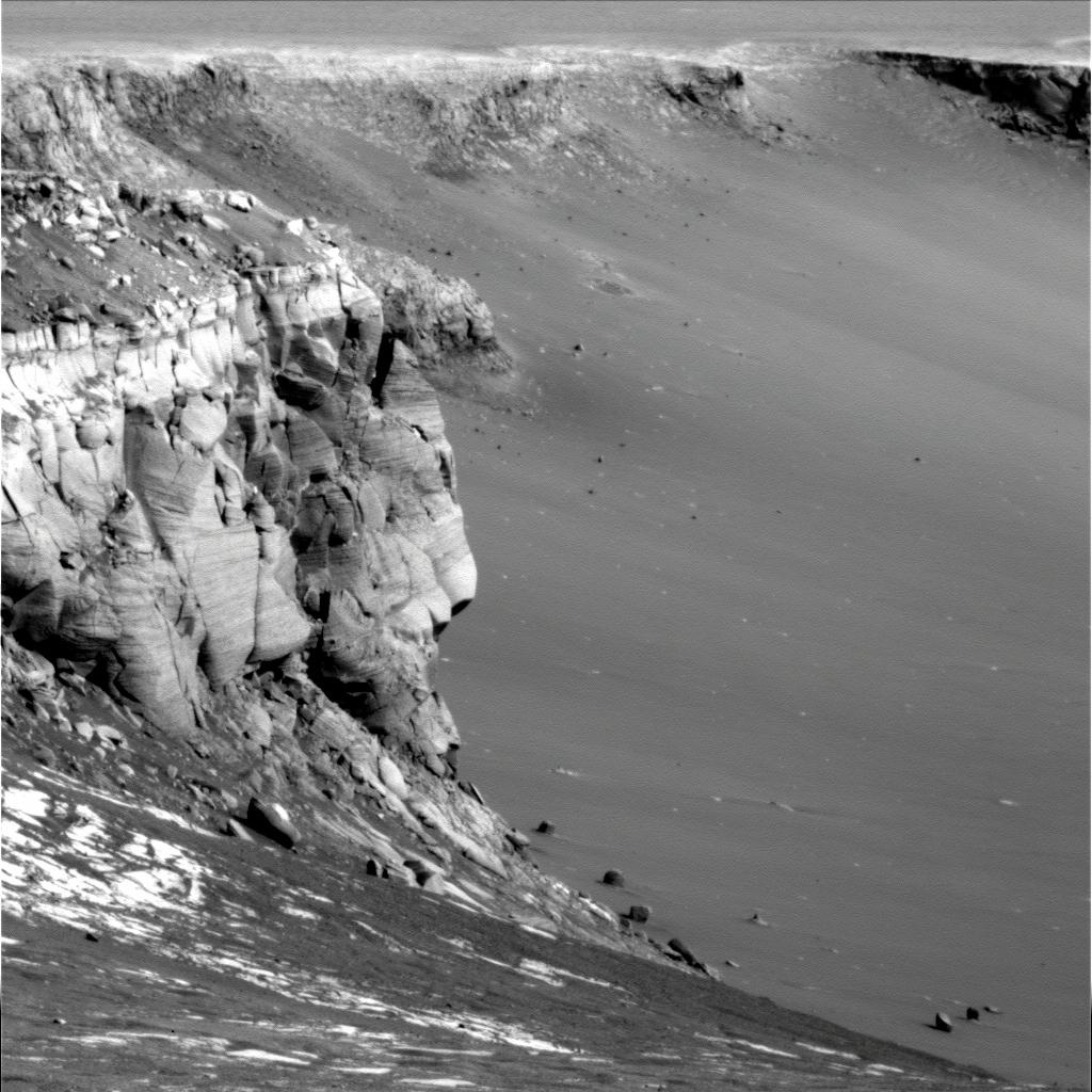 Cape St. Vincent
Opportunity took this raw image of Cape St. Vincent with its Pan Cam on Sol 1121 (March 20, 2007). Credit:NASA / JPL-Caltech / Cornell
By Sol 1116 (March 15, 2007), Opportunity was back on the road, completing the south-southwest drive to the imaging position for Cape St. Vincent. The rover spent much of the third week of the month in Valley Without Peril, imaging Cape St. Vincent. The impact that dug Victoria exposed layers that had been long buried, taking scientists back in Martian time. So far, they have found more of the same kind of geology the rover has been seeing since the mission began.
"Every promontory we've seen has the kinds of layering expected for ancient wind-blown sand deposits," Squyres said. Similar to other bedrock Opportunity has found in Mars' Meridiani region during the last three years, the layers consist of sulfate-rich sandstone with minerals from a wet period in the region's ancient past.
Although the rover hasn't found anything radically new in terms of rock types -- other than the possible new meteors it found last month -- it has uncovered "way more stratigraphic sections here" than anywhere else," Squyres pointed out. And it has taken the science team much further back in Martian history. "What that's telling us is that this is a very thick section and that the period of time in which these materials was being deposited is was significantly more extensive than what we were able to demonstrate at Eagle or Endurance. We have found, by far, the best examples of aeolian [or wind-blown] cross-bedding than anything we saw at Endurance or Eagle."
Opportunity continues to be on the lookout for rocks that might have been tossed out from layers deeper and older than the sulfates, and the place it may find them is coming up sooner rather than later on the rover's agenda. (More on that in a bit.)
This week, Opportunity completed a drive to the mouth of the Valley Without Peril, near the edge of the crater on Sol 1129 (March 29, 2007). From this vantage point, the rover is taking stereo color images with the Pancam to characterize the slopes that go into Victoria from this valley, as well as the floor of the crater. This will allow the MER team to perform a comparative analysis of other bays in their consideration of it as a possible ingress and egress point.
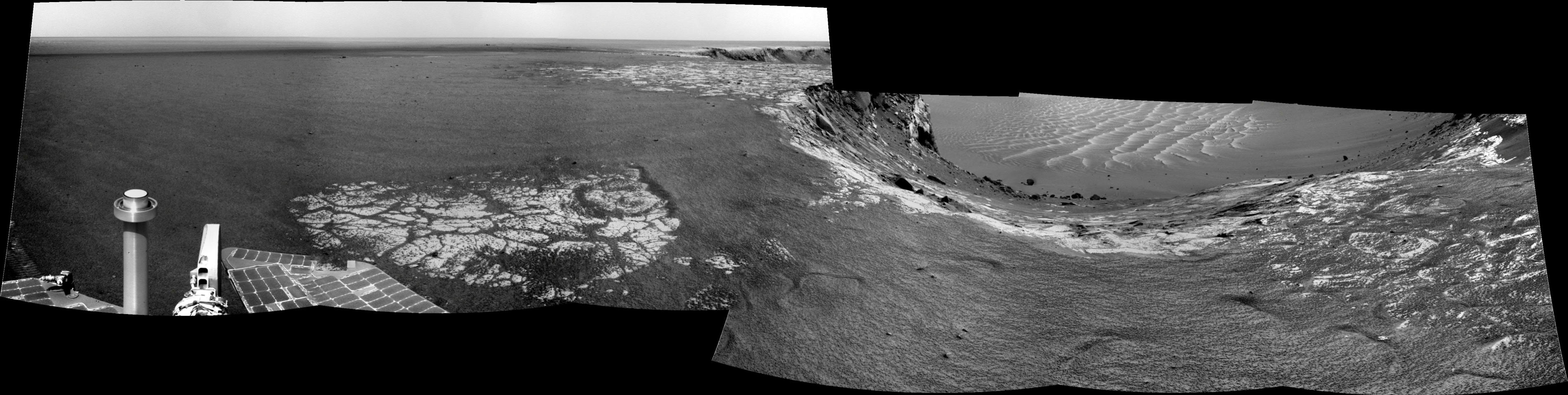 Opportunity's view on Sol 1129
On Sol 1129 (March 29, 2007), Opportunity paused in the Valley Without Peril at Victoria Crater, between the Cape of Good Hope and Cape St. Vincent, and gazed 30 degrees downward to get a good look at the slope into Victoria. Credit: NASA / JPL / Eduardo Tesheiner
Once that assignment is done, Opportunity has a full slate ahead. "We had a wonderful planning session [Wednesday] and we've actually got a plan that extends considerably into the future now for Opportunity," Squyres reported. "The next step after characterizing the slopes is to drive right into one of those dark streaks that emanate from a couple of these alcoves. We want to drive into them and find out what they are. We will drive into the darkest spot of the darkest dark streak and try to find out what's going on there."
After that, Squyres said the plan for Opportunity is to follow the dark streak back to its source at the rim of the crater, do some work there, then drive out onto the next promontory, named Tierra del Fuego, and take picture of the eastern face of Cape St. Vincent. [The area (bay) between Cape St. Vincent and Tierra del Fuego is still not named.]
"After all that, we'll be ready to try entering Victoria crater," Squyres said. "We've got two candidates. One possibility is that we'll do a toe-dip in the Valley Without Peril and do some imaging of cliff faces." That, of course, is why the rover is spending quality time imaging the Valley's slopes. "But we have to see these images first to see if the Valley Without Peril lives up to its name or not and verify that it is safe. We would not be in there for long." There is, however, "a significant probability" Opportunity won't venture in at the Valley Without Peril. "Either way, once the work is done in this area, we're going to scoot at high speed back to Duck Bay," he added. "That's where we're going to go in."
 Spherules everywhere . . .
Opportunity took this raw image of the hundreds of tiny spherules in its foreground with the Pancam on Sol 1128 (March 28, 2007), while in the midst of a picture-taking campaign of the cliffs and "bays" along the scalloped rim of Victoria crater.
Credit: NASA / JPL-Caltech / Cornell
Of course these plans are pending a "very careful safety review," said Squyres. Both the Mars Office at JPL and NASA headquarters have to sign off on the plan, since roving into Victoria could be threatening to life of rover.
The newly-revised plan means the rover will not be going all the way around Victoria's rim – at least not at this juncture. "What we're going to do after we finish our work inside the crater is to be determined," Squyres said. "We have several possibilities – continuing the circumnavigation by egressing out of the crater and going counter-clockwise, spending time looking at cobbles on the plains, or driving up to another crater, and we have several candidates for those."
But that is when. For now, the science team is anxious to get on with the exploration of the interior of the crater. "Exploring the interior of Victoria crater requires a completely healthy mobility system with 6 good wheels," noted Squyres. "We could traverse along the rim with 5 wheels just fine and we could drive to other craters, but the one thing we cannot do with 5 wheels is explore the interior of this crater, because it's too steep. We have 6 good wheels now, but will we in 6 months? I don't know. Therefore, we are strongly motivated to explore the interior as soon as we can while the vehicle health is still excellent."
That duly noted, Squyres quickly added that they have "no reason" to believe the vehicle health is going to degrade and "there are no disturbing trends." Still, Spirit's daily driving challenges with only 5 wheels is a constantly roving reminder.
Victoria is a big crater. Driving into it is a challenging mobility task. "It's time for us to get on with it and get inside," said Squyres. "We're getting real excited with Opportunity. Things are about to get really interesting."
For all the MER Updates, go to: http://www.planetary.org/explore/space-topics/space-missions/mer-updates/
Protect Our Shared Future
You help us defend humanity and prevent asteroid impacts. Donate now to become a Planetary Defender!
Donate