
 Explore Worlds
 Find Life
 Defend Earth


The Planetary Report • September/October 1989
Venus: Behind the Veil
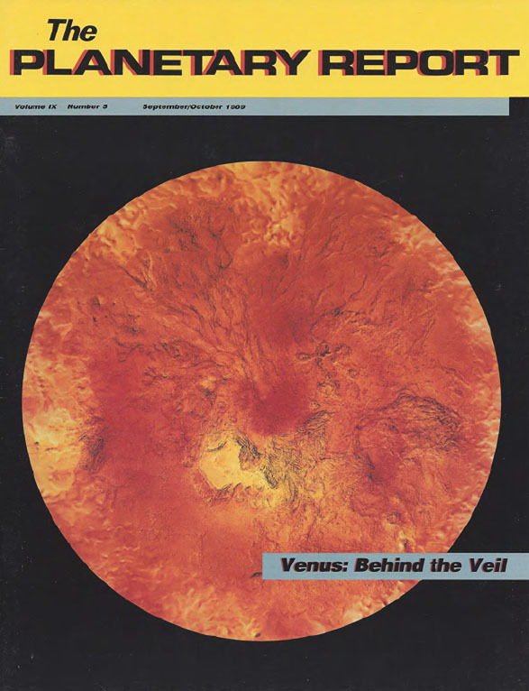
On the Cover: Using data from the <i>Venera 15</i> and <i>16</i> radar orbiters, the <i>Pioneer Venus</i> altimeter and the Arecibo radio telescope, mapmakers at the United States Geological Survey in Flagstaff prepared this topographic map of Venus' northern regions. Bright yellow regions are the highest areas, dark orange areas the lowest. The large yellow area near the center is Ishtar Terra, which contains Maxwell Montes, the highest mountains on Venus. This map is being used to help plan the <i>Magellan</i> radar-mapping mission to Venus.
Features
4 Venus: Behind the Veil: Charlene Anderson highlights the surface of Venus as viewed by Venera 15 and 16 and the Arecibo radar in preparation for the upcoming Magellan mission.
6 Galileo: The Earth Encounters: Galileo team members Theodore Clarke and Fraser Fanale preview the spacecraft's not one, but two extraordinary Earth flybys.
12 The Case for a Multinational Mars Surveyor Program: D. G. Rea, M. H. Carr, and M. K. Craig explain why international collaboration is the key to exploring Mars.
16 The Apollo Anniversary: Excerpt from the Address by President George Bush
17 Consolidating the Presidential Initiative: Carl Sagan and Louis Friedman respond to President Bush's Moon-Mars Initiative.
Departments
3 Members' Dialogue Space exploration priorities.
11 News & Reviews Voyager 2 views Neptune and Triton.
18 World Watch NASA and Soviet Mars missions; Galileo nuclear power concerns.
20 Q&A How did we decide which direction is north on Uranus?
22 Society Notes Mars rover contest winner, Mars Balloon update, and other award winners.

The Planetary Report • September/October 1989
Help advance space science and exploration! Become a member of The Planetary Society and you'll receive the full PDF and print versions of The Planetary Report.