
 Explore Worlds
 Find Life
 Defend Earth


LPSC, Friday: Mostly Titan
Written by
Emily Lakdawalla
March 17, 2008
Here is Ted Stryk's last entry on last week's Lunar and Planetary Science Conference. Many, many thanks to Ted for his informative reports! --ESL
There were several notable Friday morning sessions. Karl Mitchell discussed the possibility of polar caps on Titan, given the existence of polar lakes. There are, of course, Earth analogues -- Antarctica's ice colored lakes are an example -- so the existence of present-day lakes does not preclude ice caps. Mitchell went on to explore the possible nature of such caps.
Hanna Nekvasil presented evidence from Mars meteorites indicating hot, hydrothermal activity. Given that several Mars Exploration Rover presentations and posters dealt with evidence of hot hydrothermal formation of the "blueberries" at Meridiani, this evidence from meteorites provide excellent reinforcement.
In the afternoon Titan talks, Giuseppe Mitri presented modeling of Titanian ices in terms of what kind of mountains they could support. [The height of mountains on a world is limited by the strength of the material they are made of, how that material holds up against the force of gravity. As an example, the Himalayas on Earth are as tall as mountains can get here; although they're still being pushed up, they are sagging and spreading under the force of gravity at the same speed.] The conclusion was that mountains of up to a few thousand meters are possible.
NASA / JPL-Caltech
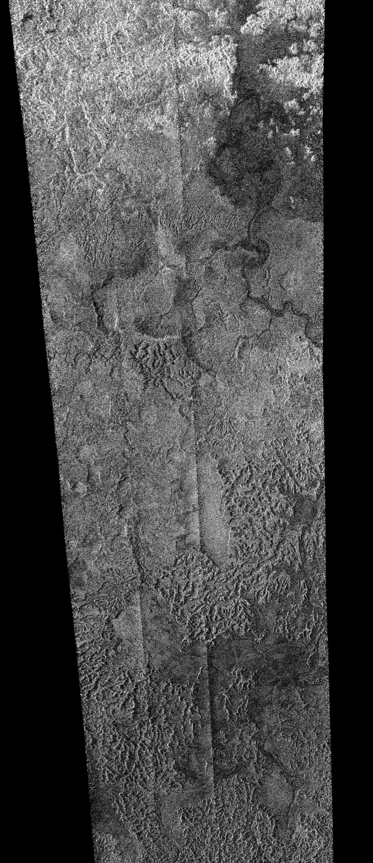
Dry rivers and lakebeds near Titan's south pole
Cassini captured this RADAR image of terrain near Titan's south pole on its T39 flyby, December 20, 2007. The image covers an area about 620 by 270 kilometers in size. The terrain is heavily dissected by the action of liquids. A variety of different mass wasting processes is probably responsible for the different types of terrain visible in this image.Ellen Stofan presented south polar radar results from the T39 flyby on December 20, 2007. Much geological variety was seen. Few lakes were spotted, which contrasts with the north polar region (only two filled lakes, and one is tiny), but this region has more channels per square kilometer than any region yet seen by Cassini, and a lot of empty lakes and other depositional terrain can be seen in the data. There also appear to be several calderas and craters, although which is which is not fully sorted out. There are evidences of straight flood channels, indicating a catastrophic event, as well as meandering channels, likely the result of longer-lived flows. There are so-called "crinkly mountains," hummocky formations that don't appear to have any organization to them. Channels can be seen meandering down from the mountains, and there are some large valleys interrupting the mountains which are thought to possibly be glacial. There area also some interesting scarps and mesas. Hopefully more complete coverage of this fascinating region can be obtained, as many seemingly chaotic areas might become more understandable with greater coverage. For example, there was an area known as "chaotic terrain" on Mars that defied explanation in the limited coverage we got from Mariner 6 and 7, but Mariner 9's global coverage revealed it to be one end of the Valles Marineris canyon system. Hopefully by the end of the Cassini mission, the RADAR, ISS, and VIMS coverage will be such that we can make better sense of the place!
Ralf Jaumann presented results to show that some of the erosion we see requires a catastrophic regional flood, which is consistent with the other results that were presented.
There are several more exciting looking presentations in the Titan session, but I can't stay any longer, so I will have to sign off.
Protect Our Shared Future
You help us defend humanity and prevent asteroid impacts. Donate now to become a Planetary Defender!
Donate