Emily Lakdawalla • Feb 13, 2007
A blast from the past: Panoramas from the early history of lunar exploration
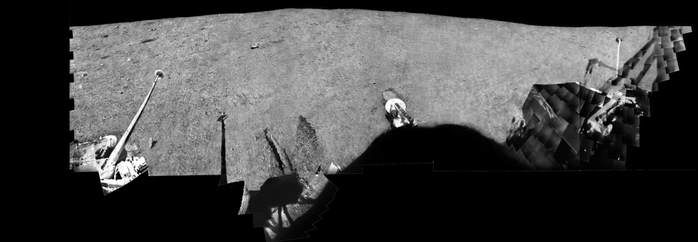
I've just posted a set of the lunar Surveyor panoramas to the lunar missions page. The Surveyor series of landers were the first from the United States to land safely on the Moon, between 1966 and 1968. They were designed to determine whether the lunar surface was safe for future manned landings. The panoramas have always been a bit difficult to look at, because the way they were produced and transmitted caused the seams between image frames to overwhelm the features evident in the Surveyors' panoramic views. They make the lunar surface look like the scales of a fish. Here's a sample panorama, from Surveyor 6, which landed 40 years ago, on November 10, 1967:

NASA
Lunar Surveyor 6 Panorama (raw)
The lunar Surveyors carried TV cameras that stared at a mirror with a pan and tilt mechanism that permitted it to scan 360 degrees around the lander and from 40 degrees above the camera to 65 degrees below it. The camera itself was tilted 16 degrees from horizontal. As images were taken they were transmitted live to Earth, where they were displayed on a slow-scan monitor coated with a long-persistency phosphor. Once displayed, they were recorded on a video magnetic tape recorder. The frames -- several hundred for each panorama -- were individually printed, assembled by hand, and then re-photographed to create panorama images.Well, University of Ontario geologist Philip Stooke has finally completed the project to clean these panoramas, giving us a clear view of the Surveyors' surroundings for the first time. Here's what the Surveyor 6 panorama looked like once he was done with it.

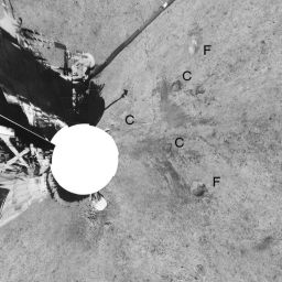
This polar projected view makes it easier to see the imprints of the footpads and crushable blocks from Surveyor 6's initial landing.

NASA / Philip Stooke, University of Western Ontario
Lunar Surveyor 6 Panorama (polar projection)
A polar projection approximates a "top-down" view on the Surveyor 6 landing site. Two days after landing, on November 17, 1967, controllers ordered the spacecraft's engines to fire, lifting the spacecraft 3 meters off the surface and setting it down again a few meters from its original landing site. This view shows the imprints of the footpads (F) and crushable blocks (C) from Surveyor 6's initial touchdown. One of the original footpad imprints is underneath the lander.Phil explains what it took to clean this panorama:
My work with Surveyor pans is very tedious and time-consuming. I told myself five years ago I would make a full clean pan of every Surveyor site. Now I tell myself I will never look at another Surveyor image as long as I live.I work in Photoshop. In the better areas I can just select small areas and lighten or darken them. In general, though, the procedure is like this:
Each Surveyor returned many pans. I could only do one of each. Each pan took about 3 months to make. This project is what academic tenure was created for! I've done nothing else for five years but teach and do this.
- I use the polygon select tool to outline one individual frame from the pan. I copy it and paste it over itself.
- I use feathered selections over dark areas to brighten them, and over light areas to darken them, adjusting to equalize contrast in each area as well. This removes the vile tonal gradients across many of the frames.
- Then - the slowest part - I zoom in on the frame borders and clean up all the bad edges so the transition from frame to frame is invisible. Many small selections are individually processed.
- Finally, I remove reseau marks and other defects using a combination of noise filters in tiny selections over each flaw, and (less often) cutting an adjacent good patch and placing it over a larger flaw (dust specks on Surveyor 6 mirror, for instance).
- Then I flatten it, back it up, and start all over again [with the next individual frame].
Phil does a lot work like this -- tedious or difficult processing of recalcitrant data sets -- which inevitably result in gorgeous images being rescued from mediocrity. In individual cases it's often not obvious to me whether the results are intended to be part of his professionally published body of work, or if they are a labor of love. I think Phil is one of those lucky people whose professional work IS a labor of love. In any case, these panoramas are, I know, part of a future book project for Phil.
Here are all the other panoramas that Phil produced. Enjoy them!


Thanks, Phil, for sharing your work with everyone! Want to see more of Phil's stuff? Visit his website.
The Time is Now.
As a Planetary Defender, you’re part of our mission to decrease the risk of Earth being hit by an asteroid or comet.
Donate Today

 Explore Worlds
 Find Life
 Defend Earth

