
 Explore Worlds
 Find Life
 Defend Earth


Mars Exploration Rovers Update: Opportunity Nears End of Marathon Valley Tour, Team Celebrates 40th Anniversary of Viking
Sols 4422 - 4451

Written by
A.J.S. Rayl
Contributing Editor, The Planetary Society
August 3, 2016
Mars Exploration Rover
NASA / JPL-Caltech / Maas Digital
Despite the intensifying rancor and ugliness of the U.S. Presidential campaigns on Earth, as the spring Sun shined down on Meridiani Planum in July, all was right with the world at Endeavour Crater: Opportunity worked some of the last of her science assignments in Marathon Valley and the Mars Exploration Rovers (MER) team celebrated its 10th mission extension and respectfully paid tribute to Viking, one of the giants in the history of Mars exploration and the first American mission to safely land robots on the rusty red surface.
“We've been extended for two more years and we're very excited,” said John Callas, MER project manager, at the Jet Propulsion Laboratory (JPL), home to all NASA’s Mars rovers. “We're pleased with the results and recommendations and that NASA has acknowledged those recommendations.”
The two-year mission extension assures that the first overland expedition of the Red Planet and Opportunity will rove on, funded through 2018, barring any unforeseen budget crises. The plan forward will take the rover places no Mars surface mission has ever gone and test the mettle of the golf cart size emissary in ways that she has never before been tested.
“We're very pleased with the way the review came out,” said Steve Squyres, MER principal investigator, of Cornell University. “The Senior Review Board clearly appreciated the story we had to tell, especially our story about what we're going to be doing during the two years ahead of us.”
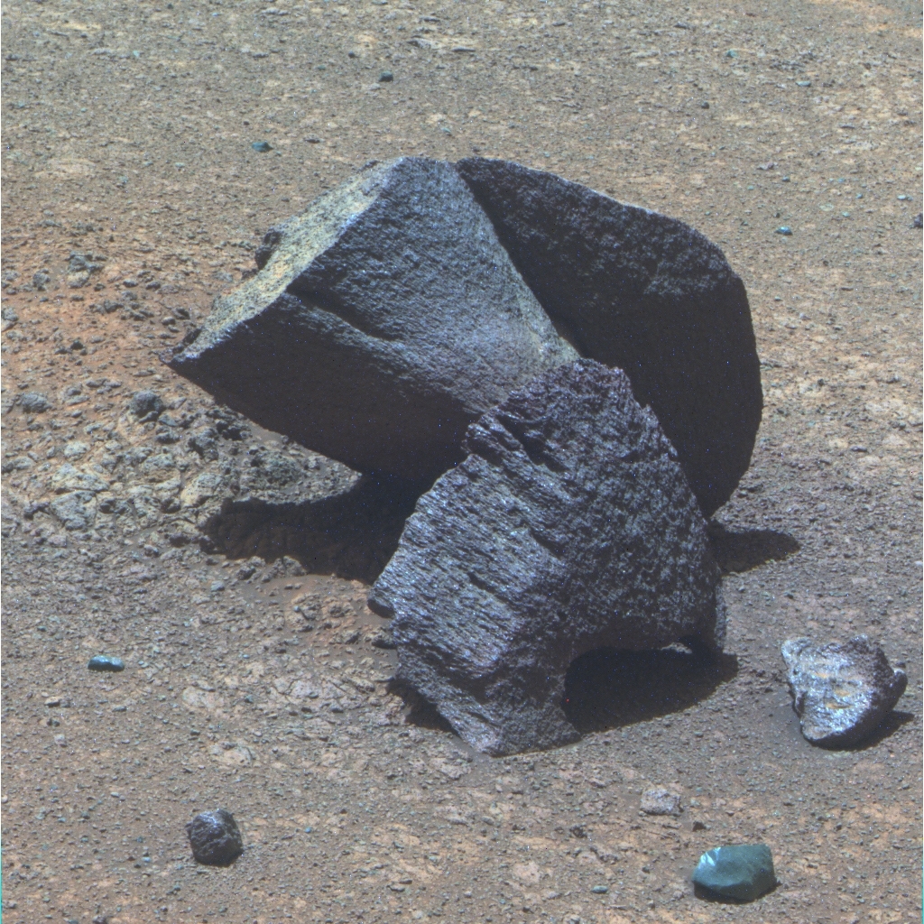
Sleepy_II
Opportunity roved upon this intriguing suite of “purple” rocks nestled together on the floor of Marathon Valley toward the end of July, as she was on her way to shoot a new segment of the valley’s north wall. Purple rocks, which look purplish in the false color Panoramic Camera (Pancam) versions of images, and which the MER scientists have determined fell off from the valley’s northern wall, contain more silicon and aluminum.NASA / JPL-Caltech / Cornell / ASU
Since landing in January 2004 for a three-month tour, Opportunity has been crater hopping and exploring the Meridiani plains. During the last twelve and a half years, the rover and her handlers have taken the scientists just about everywhere they wanted to go, through wind-blown ripple fields and across vast stretches of plains, inside craters and up onto eroded crater rim segments, uncovering Martian surprises and sending home evidence for past water again and again.
Along the way, the rover that loves to rove has broken robot records and established new milestones, including finishing the first marathon and becoming the longest-lived robot on another planet years after surviving a planet encircling dust storm she wasn’t designed to survive. The MER ops team in the process has become the tightest, most experienced Mars rover team on Earth. And now the mission is getting ready to embark on what ultimately may be the most exciting adventure of all.
The rover planners at JPL will drive Opportunity down steep, rugged slopes, and over more Martian hills and dales to places where geological features beckon the scientists, rousing visions of discovery that dance in their heads. First, the rover has a little more work to do to wrap the science campaign in Marathon Valley.
For most of July, Opportunity checked out rocks on the floor of the valley. But by month’s end, she had moved on and initiated her final assignment, taking dozens of Panoramic Camera (Pancam) images of the most eastern segment of the valley’s north wall that she will visit.
“We’re at the tail end of the Marathon Valley Farewell Tour,” confirmed Ray Arvidson, MER deputy principal investigator, of Washington University St. Louis (WUSTL). “Once we complete this imaging, we’ll exit the valley and get started on the extended mission.”
During the past year, Opportunity has been searching for evidence of ancient clay minerals and any other signs of past water inside the valley that cuts the eroded western rim of Endeavour. The mission was drawn to the valley because the Compact Reconnaissance Imaging Spectrometer for Mars (CRISM), from its post on the Mars Reconnaissance Orbiter (MRO), had detected the signatures of phyllosilicates there, specifically a mother lode of smectite clay minerals, and because it offered “friendly” slopes where the solar-powered robot could take in as much sunlight as possible during the mission’s seventh Martian winter.
But the remnant smectites weren’t obvious, the search was not easy, and the hypothesis the scientists initially formed didn’t entirely bear out. The MER science team had proposed that the rover would not only find evidence of the ancient clay minerals but rocks from the most ancient Martian ground ever discovered by a surface mission, known as Matijevic Formation.
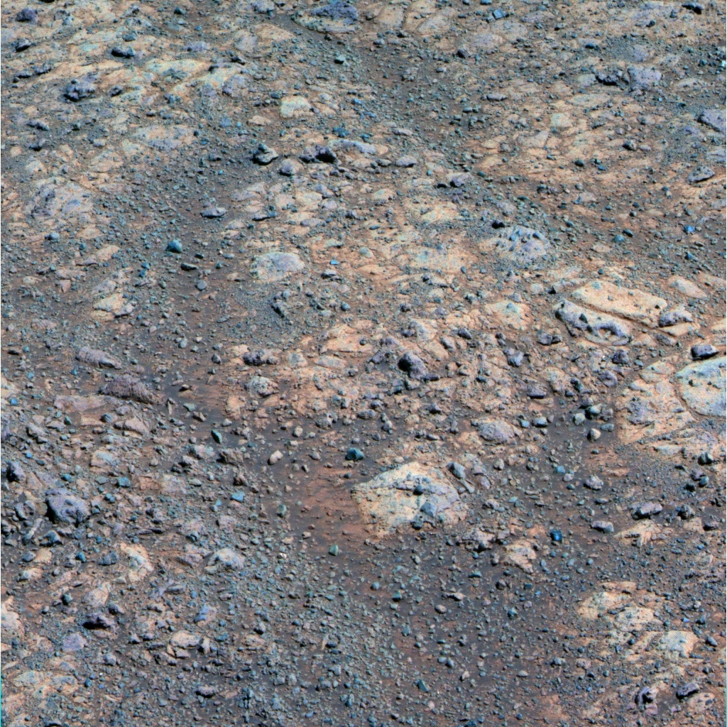
Red Zones
This image, which Opportunity took in May 2016 with her Pancam, shows some of the deep red bands that swirl around the bedrock in Marathon Valley and make-up the “red zones.” The bands are actually fractures where the MER scientists maintain extensive amounts of past water rose up and permeated the area over a sustained period of time, causing leaching and deposition of other minerals associated with water.NASA / JPL-Caltech / Cornell / ASU
Opportunity first roved onto the flat, light-toned bedrock on Matijevic Hill at Cape York in 2012 (hence the strata’s appellation). It’s where the mission became the first ever to ground-truth and characterize phyllosilicates on Mars. The rover’s location in Marathon Valley however is topographically higher, about 84 meters (275.59 feet) higher in elevation than Cape York and the rover found no Matijevic bedrock there. But, as Squyres put it, the team did find “a very different story.”
A couple of months ago, while the Marathon Valley Tour was driving into in its final weeks and the Martian winter was receding, the MER scientists concluded that the residue of iron and magnesium smectite clays are spread all over the site, in and around the breccia bedrock that was hurled up and formed three to four billion years ago with the impact that created Endeavour. And, they determined that those clays formed in relatively “mild” amounts of water.
However, between the bedrock exposures are deep reddish bands or zones that are likely ancient fractures where a lot of water rose up and permeated those areas. The rover found crumbly jumbles of soils and pebbles in these fractures probably because the areas were so water-altered over a sustained period of time.
With the Marathon Valley story largely in the can and the Martian winter in the rear view mirror, the team was ready to finish the science in the valley and press onward. And so in July, Opportunity began the last of the investigations the team would conduct on the floor of Marathon Valley.
As that final science campaign got underway, the team changed the naming theme for rocks and other features. “We're finished with Lewis & Clark names and now celebrating the 40th anniversary of Viking,” Squyres said.
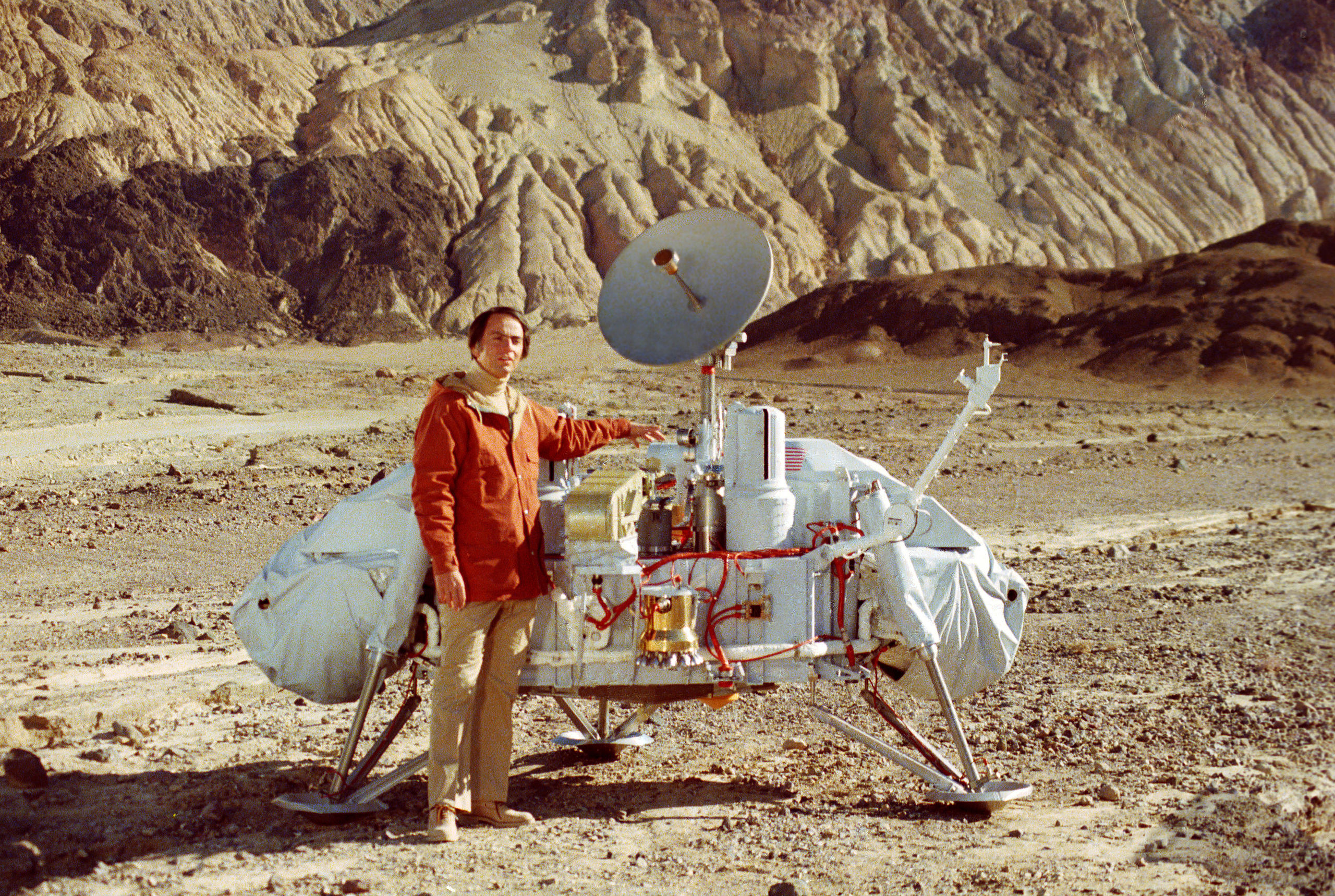
NASA / JPL-Caltech
Carl Sagan with Viking Lander
In this image taken in the 1970s Planetary Society co-founder Carl Sagan, a Viking mission team member, poses by a model of the Viking Landers in Death Valley, CA. One of the original space-blazing scientists, Sagan became the leading voice and face of science in the second half of the 20th Century. He is widely remembered for the award-winning PBS series Cosmos: A Personal Voyage and his many popular science books, including Dragons of Eden, Broca’s Brain, and Pale Blue Dot, and the novel Contact, which later was turned into a film, starring Jodie Foster and Matthew McConaughey. From Carl, we learned that there are billions and billions of stars and planets in the universe, and while no one can say for sure what we will ultimately find out there, as he once put it: "Somewhere, something incredible is waiting to be known."On July 20, 1976, Viking Lander 1 became the first American spacecraft to land successfully on Mars and carry out its mission. That robotic lander held the record for the longest Mars surface mission, 2245 sols or Martian days, until Opportunity broke it on May 19, 2010.
MER’s tribute involves christening the final targets in Marathon Valley after the rocks named at the Viking lander sites, said Arvidson, who has collected more Martian dust on his khakis than any other Mars geologist. In fact, MER’s deputy principal investigator first “landed” on the Red Planet with Viking and served as the team leader of the Lander Imaging Team from 1977-1982.
Once Opportunity finishes shooting the panorama of the valley’s northern wall, the mission will exit stage south, through a break in the rim at the southeastern edge of Knudsen Ridge to start the extended mission. “We're going to proceed to Lewis & Clark Gap, and then decide once we get there which specific route that we're going to take to begin the first leg of our next extended mission,” said Squyres.
“The scenario that we laid out in our extended mission proposal was that we would exit and pass through the gap and then head downhill from there to the left,” [east or toward the crater floor], Squyres informed. If the Lewis & Clark Gap looks too difficult or too challenging, they already have an alternative route charted that will take the rover south along the ridge. “And then, we’ll hook a right further down Marathon Valley,” he said.
As Opportunity navigates the craggy slopes into Cape Tribulation, she will be, if all goes as expected, also driving back in Martian time. If the rover travels far enough downhill, she probably will find those Matijevic Formation rocks. Time will tell.

First color image from Viking Lander 1
This color picture of Mars was taken July 21, 1976, the day after Viking Lander 1's successful arrival on the Red Planet. The lander touched down in Chryse Planitia, a smooth circular plain in the northern equatorial region of Mars, and then spent some 6 years taking pictures and data, and even conducted an experiment in search of microbial Martian life, the results of which were controversial but are still being debated today. MER Deputy Principal Investigator Ray Arvidson served as the team leader of the Lander Imaging Team from 1977-1982.NASA / JPL
When the robot field geologist’s quest to find more Matijevic Formation rocks is deemed over, the mission will move on to Cape Byron and a geological feature no Mars surface mission has ever before investigated. “The big story is that even after twelve and a half years on Mars, we still have the most exciting objective ahead of us: the exploration of a Noachian, water-carved gully dating from earliest epoch on Mars,” said Callas.
The Noachian Period, 3.7 to 4 billion years ago, was the time most planetary scientists believe Mars was more like Earth, with rivers, deltas, lakes and maybe even an ocean. And so, not surprisingly, a long-held hypothesis has been that old Martian gullies have been carved by liquid water, much like gullies on Earth. To be able to study one of the most ancient ones up close is a big Martian deal.
“It is the centerpiece of our extended mission,” Squyres said, “a wonderful, an unprecedented opportunity to explore something that has never been seen on the ground before.” And, added Callas: “We're the only asset on Mars that will look at a Noachian gully in situ for the foreseeable future.”
Interestingly, on July 29th JPL and the Johns Hopkins University Applied Physics Laboratory (JHUAPL) issued a press release announcing new findings that show that gullies on modern Mars are likely not being formed by flowing liquid water. Using orbital data from CRISM, correlated with images from the High Resolution Imaging Science Experiment (HiRISE) camera and Context Camera (CTX), all instruments on MRO, researchers from JHUAPL examined more than 100 modern gully sites on Mars.
The findings, published in Geophysical Research Letters, showed no mineralogical evidence for abundant liquid water or its by-products, and pointed to mechanisms other than the flow of water, such as the freeze and thaw of carbon dioxide frost, as being the major drivers of recent gully evolution.
The operative word in that press release is “modern.” The features described in the press release are fundamentally different from the feature Opportunity is going to explore. “The gullies the press release talks about and the gully that we're going to investigate are completely different beasts and have almost nothing to do with each other,” said Squyres. “We're confident that water was involved in creating this feature at Cape Byron. That I think we can say with a pretty high degree of confidence. Where the uncertainty comes in is how much water and over what period of time,” he said.
One theory is that the gully was formed by a “liquid water stream” that flowed “maybe gently, maybe aggressively, over the surface for some period of time, something we see on Earth,” Squyres said. Another possibility is that it was formed by a debris flow, a moving mass of loose mud, sand, soils, rock, and water, a kind of “water-lubricated slurry” that “transports a lot of debris in a big hurry,” fairly rare occurrences on Earth.

Independence View
While most Americans took the day off to celebrate the 4thof July with fireworks, Opportunity worked on Mars. The veteran robot field geologist took this image on July 4, 2016, as she was driving to the floor of Marathon Valley to finish her science campaign there. This image, which shows the ripple-rich floor of Endeavour Crater, was processed in false color by the Pancam team, a technique that enables the scientists to better discern the various different geological elements.NASA / JPL-Caltech / Cornell / ASU
The scientists also want to investigate the extent to which there may have been avalanching. “This gully or valley, whatever you want to call it, has had a gradient of about 15-degrees its entire life and because of that we're confident that it wasn't formed by avalanching alone, because it's not steep enough. But we do have to examine the possibility,” said Squyres. “These are the kinds of things you can't tell from orbital images, but only by making measurements on the character of materials in the gully itself – things like grain size, how the grains are sorted, how grain sizes change as you go downstream. We need to look at the actual deposits and figure out which process was involved,” he said.
The bottom line is that the MER scientists have several credible hypotheses of how this feature might have formed. “And every credible hypothesis we have involves water to some degree,” said Squyres.
It seems safe to project that no matter what they find in the gully and around Cape Byron, it will be a significant chapter in the annals of Mars exploration. “We have not found any evidence for clay minerals in Cape Byron with CRISM data,” said Arvidson, who is a CRISM co-investigator, recently honored for his work with the 2016 Lester W. Strock Award given by the New England Section of the Society of Applied Spectroscopy. Nevertheless, “there are other very interesting things we can do to build on discoveries we have made over the previous 12 years,” Squyres said.
Once the top-to-bottom gully study is finished, the current plan calls for Opportunity to drive down onto the bench on the inner side of the rim, said Callas. From there, the rover may skirt inside Endeavour to check out some “mega ripples.” And there are some fresh crater impacts both inside and outside along the path that may harbor untold revelations about Mars’ past. After that, “we plan to work our way south,” he added.
As for Opportunity, she is, as she has always been, ready to roll. “The vehicle is in good health and now is as good a time as ever to push the limits of Opportunity and see if we can get more new science by exploring terrain we may have thought was unreachable when we landed,” said Mike Seibert, MER lead flight director and rover driver. “We're looking at probably the most exciting extended mission I've ever seen. From an engineering standpoint, it's going to be a challenge to operate Opportunity and go where the science team wants us to go.” But, it's something that we can do as a team,” he added. “We've learned a lot in these twelve and a half years.”
It won’t be long now before Opportunity will leave Marathon Valley for good and hit the Tribulation Road. “I want to get going,” said Squyres. “We’re all eager to get a jumpstart on this extended mission,” agreed Seibert.
NASA / JPL-Caltech / Cornell / Arizona State University
Marathon Valley
The above image is a false color version of the MER mission’s latest panorama, a view through Marathon Valley, which garnered its name because the rover’s arrival in this area along the western rim of Endeavour Crater coincided with her completion of the first marathon on another planet beyond Earth. Opportunity first entered the valley in July 2015 and in slated to leave in August 2016. The rover team calls this Sacajawea Panorama, in honor of the Lemhi Shoshone woman, whose assistance to the Lewis & Clark Expedition helped enable its successes in 1804-1806. Team members named many of the rocks and other features in Marathon Valley for members of the expedition officially known as the Corps of Discovery. This image was processed by Kelsie Crawford and Jim Bell, of ASU.As July dawned at Endeavour, Opportunity was stationed at York, a bedrock target on the slope along the southeastern part of Marathon Valley’s southern wall where she had been working since April. Although the rover had departed the slope and drove to the floor of the valley in late June, the Pancam images of York that she had downlinked just before roving on had been lost in transmission to Earth.
So Opportunity turned around, returned to York to take the desired pictures of the bedrock target. The rover actually finished up the re-do imaging on Sol 4419 (June 29, 2016), but because of the importance of these images and since the rover planners could not confirm data arrival before the next planning session slated for Sols 4420-4422 (June 30-July 2, 2016), they commanded the rover to stay put. Never one to be idle, the robot spent the time taking pictures of her Rock Abrasion Tool (RAT) bit, so the Honeybee Robotics team that built and oversee the instrument could assess its condition.
The weather was pleasant enough as July took hold especially considering that Martian spring winds are notorious for causing dangerous dust storms that can be deadly to robots. But the mission’s lucky star continued to shine and Opportunity worked under “storm-free” skies throughout the month, according to the Mars Weather Report issued weekly by Malin Space Science Systems, which operates the Mars Color Imager (MARCI) onboard MRO. In fact, the sky was only slightly hazy with the rover recording a Tau or atmospheric opacity level of 0.551, akin to a somewhat smoggy summer day in Los Angeles.
Better still, Opportunity had plenty of energy. With 42.91 kilometers (26.66 miles) on her odometer, the solar powered rover was utilizing more than 70% of the sunlight hitting her arrays as the month began and was producing fairly robust power levels of 645 watt-hours. That’s more than half her full capability after landing way back in 2004 with clean solar arrays.
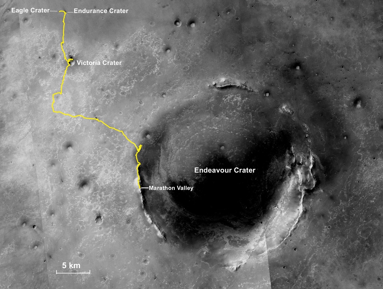
Oppy’s expedition so far
The gold line on this image shows Opportunity's route from the Eagle Crater landing site to her approximate current location. Since August 2011, the MER mission has been exploring the western rim of Endeavour Crater and in July the rover entered Marathon Valley. The base image for the map is a mosaic of images taken by the Context Camera onboard the Mars Reconnaissance Orbiter (MRO). Larry Crumpler, of the New Mexico Museum of Natural History and Science, provided the route add-on.NASA /JPL-Caltech / MSSS / NMMNHS
Once MER ops team members confirmed receipt of the Pancam images of York, the team commanded their robot field geologist to head back toward the site dubbed The Mesa on the floor of Marathon Valley. The rover took off on Sol 4423 (July 3, 2016) heading northwest and completed the trek on Sol 4426 (July 6, 2016) with a 15.45-meter (50.68-foot) drive. As always, Opportunity took the usual post-drive Navigation Camera (Navcam) panoramas, which give the ops team the visuals they need to finalize the plan for the next drive.
The rover meanwhile ended the first week of July working with the MER software engineers on the ongoing Flash bank readout task to see if they can find any hint as to why the rover’s long-term or non-volatile memory continues to cause unwanted reboots every time they turn it on, as well as “amnesia events,” where the memory drive simply fails to launch.
As for the prospects of Opportunity turning on and using her Flash again, Callas said: “It's always possible. We haven't ruled it out. But we're not spending a lot of time on it. We're focused on the exploration we have that we can and will do.”
To that end, the rover also spent some time that sol taking more targeted Pancam images of her surroundings, and continued taking images during the first two sols of the second week of the month, 4428 and 4429 (July 8 and 9, 2016). Then, on Sol 4430 (July 10, 2016), she drove 8.33 meters (about 27.33 feet) toward a rock target of interest, taking the usual post-drive Navcam panoramas at the end of the excursion.
On Sol 4432 (July 12, 2016), the rover bumped slightly, just a centimeter or two to position herself for in-situ or contact work on Bashful_II, a purple rock the scientists wanted to compare to other purple rocks the rover had previously come across and studied. The MER team named the rock after one of the rocks that the Viking Lander 1 checked out, and with that shifted to its new naming theme.
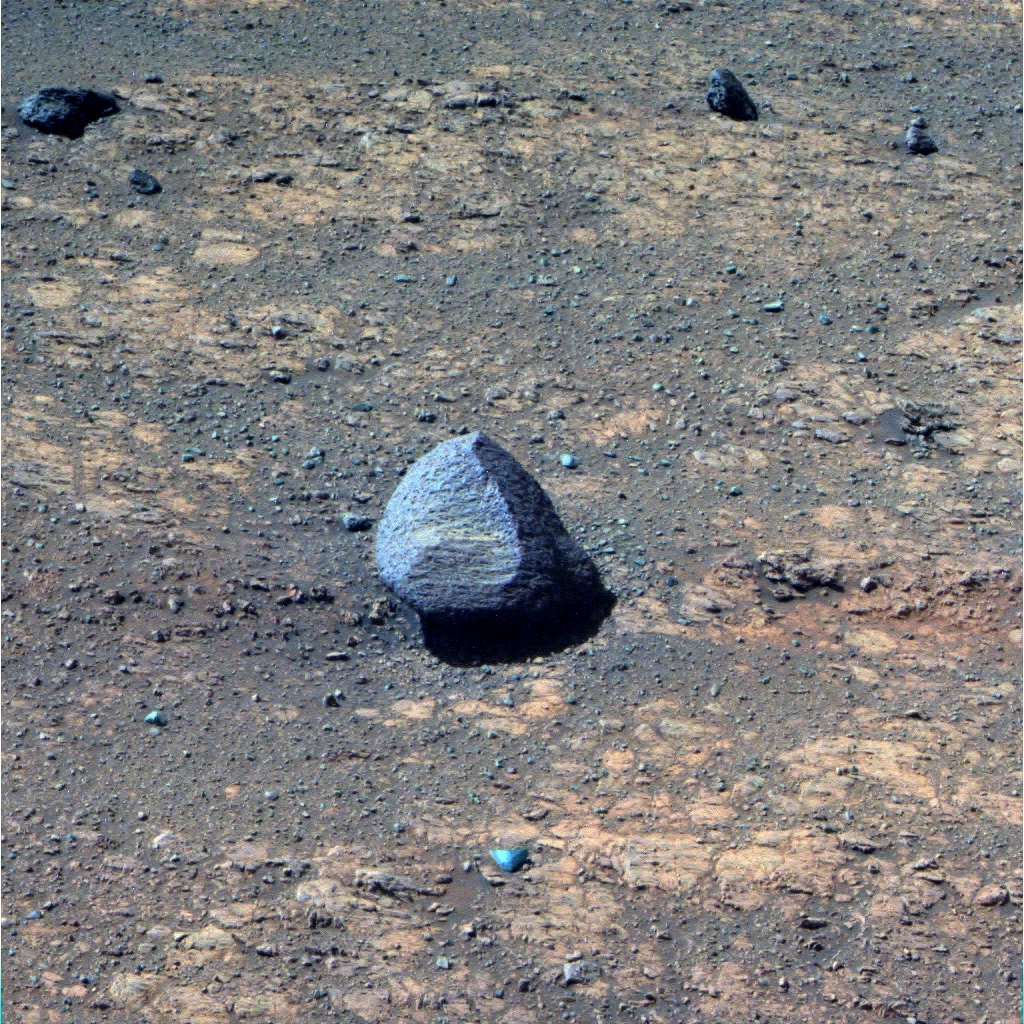
Bashful_II
Opportunity took this image of the purple rock she examined up close in July 2016 with the instruments on her Instrument Deployment Device (IDD). In honor of the 40thanniversary of the Viking mission to Mars, the MER team named it Bashful_II, after the rock Bashful that Viking Lander 1 checked out back in 1976. The image was processed in false color by the Pancam team.NASA / JPL-Caltech / Cornell / ASU
At Bashful_II, Opportunity followed what has become the science protocol, taking close-up pictures with her Microscopic Imager (MI) for a larger mosaic, and then placing her Alpha Particle X-ray Spectrometer (APXS) on the target to glean its chemical composition.
“We did IDD work on Bashful_II and it looks pretty much like Jean Baptiste Charbonneau, the purple rock that we did up on the ridge north of Marathon Valley,” said Arvidson. “It has the same composition.” Notably, both rocks are slightly higher silicon and aluminum. “We also basically confirmed the purple rocks that we're seeing on the floor have fallen off Marathon Valley’s northern wall and rolled onto the valley floor.”
During her stop at Bashful_II, Opportunity also took extensive Pancam color images of Hinner's Point, which caps the valley’s north wall, After taking the pictures needed for another MI mosaic of the purple rock on Sol 4436 (July 16, 2016), the robot offset the placement of her (APXS) just 1 centimeter (0.39 of an inch) to re-analyze its chemical composition. And then Opportunity bid adieu to Bashful_II, taking off the next sol with a 16-meter (52.49-foot) drive toward the base of Hinner’s Point.
The plan called for the rover to continue driving on Sol 4438 (July 18, 2016), but just as she initiated the turn for the drive, Opportunity stopped in her tracks. An issue with her right-front wheel caused the flight software to terminate the drive.
Initial thinking was that the terrain was causing excessive load on the right-front wheel. But the ever-cautious rover engineers wanted to conduct a set of diagnostics on Sol 4439 (July 19, 2016). That analysis also pointed to a terrain issue, but the engineers planned more diagnostics were for the next sol, 4440 (July 20, 2016), the day that marked Viking 1’s 40th anniversary.
“We saw some higher than expected currents and out of an abundance of caution we did some diagnostics,” said Seibert. “With a 12-and-a-half year old rover, we don't cowboy it if we see something on the drive train behaving out of bounds.”
Working with the rover planners, the robot carried out those diagnostic tests on her wheels and during that checkout she backed up 1.28 meters (about 4.20 feet). “That bump was part of the diagnostics we did on the right front wheel issues,” said Seibert. The tests were nominal and the engineers think it was, as they suspected, a terrain interaction during what was a difficult turn in place for the rover. All’s well that ends well, and, as Seibert summed up: “All is well.”
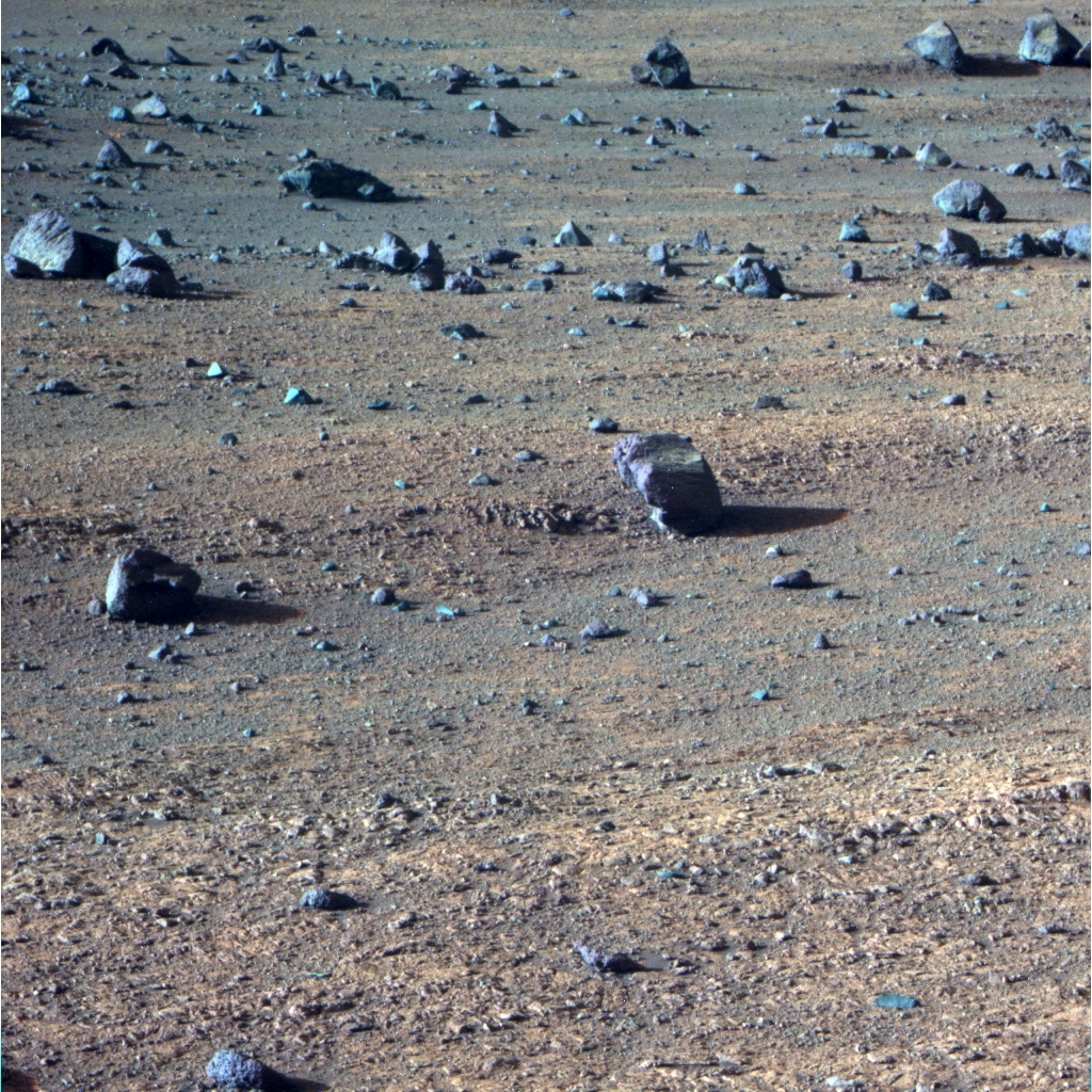
Boulder field
Opportunity and the MER rover drivers had to navigate through a boulder field, part of which is pictured above, in July 2016. The rover was on her way deeper into Marathon Valley, heading for the eastern most segment of the valley’s north wall that the mission will visit. This image was processed in false color by the Pancam team.NASA / JPL-Caltech / Cornell / ASU
Opportunity hit the road again on Sol 4441 (July 21, 2016), driving 34.7 meters (113.84 feet) heading toward an open path in the boulder field below Hinner’s Point. “That boulder field creates an obstacle course,” said Seibert. “If it was on flat ground, we would consider going straight through it, but it's on a 15-degree-plus slope.”
Caution prevailed. There’s no way the rover planners are going to take a chance with this amazing Martian asset. As it turned out, the drive went like clockwork and when she stopped, Opportunity took the routine post-drive Navcam and Pancam images. The following sol, the rover completed a full 360-degree Navcam panorama and also took some Pancam images of selected targets.
The robot field geologist drove again on Sol 4443 (July 23, 2016) and cruised right through the edge of the boulder field to a clearing of sorts, putting 25.84 meters (84.77 feet) in the rear view mirror. It was another record setting run: Opportunity passed the 43-kilometer mark, pushing her odometer to 43.046 kilometers (26.747 miles). And of course, after the historic drive, the rover took the usual post-drive images of her location.
The next morning, Sol 4444 (July 24, 2015), the robot shot a cloud movie, took care of routine business, and then got a good night’s rest. On Sol 4445 (July 25, 2016), she drove another 33.17 meters (108.82 feet) pulling up close to the base of a segment of the valley’s north wall that the rover had not yet imaged. There, she took images of an intriguing suite of purple rocks nestled together on the valley floor, which the team dubbed Sleepy_II. “It’s pretty cool these two or three rocks sitting there right next to each other,” said Arvidson.
“We decided to drive from Bashful_II directly to the north valley wall and stopped about 8 to 9 meters to the south of it,” said Arvidson. “We did the usual Navcam imaging and planned a whole set of Pancam observations of this part of the north valley wall. We've never been this far into the valley, it's a brand new wall segment, and it’s the eastern most portion of the northern wall that we'll get to.”
As July wound down, Opportunity was in the midst of that campaign, using her Pancam to image that north wall segment where rocks are exposed. She homed in on a target and took MI images for a mosaic the team named Gibraltar_II, “because it’s so impressive,” said Squyres.
Soon Marathon Valley will be history. While the rover didn’t find exactly what the scientists expected to find there, the mission’s winter science campaign in the valley, Squyres and Arvidson and others agree, was “a great success,” as Arvidson put it.
“We had formulated a hypothesis for what we would find when we got there. We tested the hypothesis and it turned out to be incorrect and we found something else,” said Squyres. “We have come up with what we now think is a good, detailed, sensible publishable understanding of what we found in Marathon Valley.”
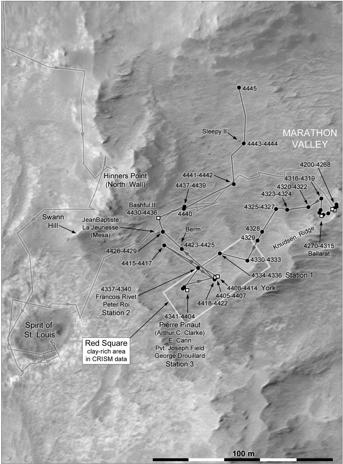
Route map
This map of Opportunity's recent rovings and science stops was charted by Phil Stooke, associate professor, University of Western Ontario, Canada, and author of The International Atlas of Mars Exploration Vol. 2, Spirit to Curiosity: 2004 to 2014, Cambridge University Press, 2016. The base image was taken by the HiRISE camera onboard MRO.NASA / JPL-Caltech / UA / P. Stooke
“The rocks that show the smectite signatures, whether from orbit or from the ground, all suggest mild alteration by water, except when you get into the fractures,” Arvidson said, reiterating what he said last month.
The fractures or red zones are where the scientists maintain extensive amounts of water flow caused leaching and deposition of other minerals associated with water, such as sulfate-bearing minerals. “The red zones are surface expressions of places where the preexisting fracture system allowed water to come to the surface and produce localized alteration, and it's been pretty pervasive,” said Squyres. “Actually, that's the reason there's no bedrock in the red zones, the stuff there is just completely weak and crumbly as a result of being altered.”
That is “consistent” with what they saw at Matijevic Hill, Arvidson noted. Interestingly, it’s also consistent with what Curiosity has found at Gale Crater, where the bigger, badder laser-zapping rover is traversing ancient river, lake, and delta deposits. “There was a lot of water at Gale, but not a lot of aqueous alteration except in the fractures,” he said.
Opportunity’s research in Marathon Valley has enabled the MER scientists to “pin down” the finding that the iron and magnesium smectites the rovers have checked out, and perhaps other iron and magnesium smectites discovered from orbit around other parts of Mars, formed in a low water-to-rock ratio or relatively “mild” amounts of water, summed up Arvidson.
As the Sun set on July, the rover was still shooting images of the new northern wall segment. “We want to understand what the heck's going on – is it a fault, just erosional, or what?” Arvidson said.
It won’t be long now before Opportunity and her Earthbound colleagues will be roving onward into new terrain, new trials, new experiments. “We'll probably not do any more IDD work after this,” said Arvidson. “We’ll probably turn around and head to the Lewis & Clark Gap, the exit point, and get on with extended mission.”
And then, the real excitement will begin – all over again.
For all intents and purposes, driving around Marathon Valley has been smooth sailing, but in coming weeks and years the rover is likely to encounter some of the roughest “chop” she’s ever experienced.
“With the pictures the rover has returned, you can see that we've been driving around this nice outcrop and bedrock in Marathon Valley,” said Seibert. “Further to the south, it looks more textured and seems like there's a change in color, shadows likely being cast by rock, and there may be larger rocks we have to avoid. And, the driving is going to be on 15-degree slopes for the most part.”
“We cannot go all the way down the valley, because it's too steep and the terrain is too difficult and we won't be able to get back up to areas that we think are exciting to us,” said Callas. “But we do want to go down as far as we safely can stratigraphically, because we want to search for these Matijevic Formation rocks, which is where we found the clay minerals at Cape York.”

Mars Day 2016
Mars Day 2016 took place July 29that The Smithsonian National Air and Space Museum. The annual event celebrates the Red Planet with a variety of educational and fun family activities, and MER team members. Mike Seibert, MER lead flight director and rover driver, of the Jet Propulsion Laboratory (JPL) took time to talk about the mission and Opportunity’s amazing achievement. John Grant, a geologist with the Center for Earth and Planetary Studies at the Smithsonian’s National Air and Space Museum, who helps lead the daily science planning and operations, was also on hand at the event.Mike Seibert
Traversing the slopes of Cape Tribulation will likely be one of the most intense and challenging things Opportunity has ever done. “The driving will be more difficult,” Seibert admitted. “We will also have some communication challenges, because there will be times the orbiters’ overflights, which we use to send data back to Earth, will be so low on the western horizon that they will barely peek above the rim of the crater, and those passes won't return much. And, as long as we don't have Flash enabled, that means we can only get a trickle of data back on those sols. That can slow down our operations pace a little bit.”
Anything could happen in this treacherous Martian terrain, but with the care and concern this team has always had for their field geologist, this rover’s fate is in the most experienced and capable hands in the solar system. The MER drivers are ready, willing, able and dedicated beyond measure.
“When we're driving, we could experience slip downhill and driving across slope that could pull us off our heading, so we have to be really careful how we're tracking the rover's position,” Seibert said. “Thankfully, our Visual Odometry system allows us to more accurately track our position, but it's going to involve more periodic safety checks during driving. Even when we're not driving, the rover will be tilted to the east, so we'll have more power early in the sol, but our effective sunset, due to rover's tilt and the crater’s rim, means that we’ll lose a bit of time at the end of each sol where the solar arrays no longer generate any power.”
Still, these challenges are a part of what the excitement is all about, especially for the rover drivers, not only because Opportunity will be going where no rover has gone before, but because the tilt and terrain will give them experience and perhaps some thrills of a lifetime. “It will make for very interesting operations,” said Seibert, “and it’s definitely going to be exciting.”
Opportunity is ready and so far Mars is cooperating. The weather has been good with the spring dust storms keeping their distance and the rover’s power levels are still in excess of 600 watt-hours.
The really good news is that each of the currently charted routes is reversible. “Had we decided to go down Marathon Valley all the way into the crater, it would be likely one way, and that's why we didn't go that way,” said Callas. “Even though we expect to follow the gully down to the floor of Endeavour at the end of our extended plan for the next two years, there is an exit point where we can come back out again if we want to exit and head for Iazu or other ambitious targets.”
After twelve and a half years into what was originally slated to be a three-month tour, how can anyone not marvel over this rover, this team, this mission? The planet, of course, has played a hugely important role in this magical story too, and as the MER mission heads into its tenth extension Mars continues to be, as the team is wont to say, "cooperating."
“Mars,” Squyres acknowledged, “has been really good to us.”
NASA / JPL-Caltech / Cornell / Arizona State University
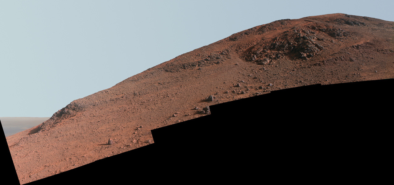
Knudsen Ridge
Opportunity took the dozens of images that went into this panorama of Knudsen Ridge over a period of sols or Martians days in October 2015 and she finished filling in ‘holes’ in February 2016. The rover will be exiting Marathon Valley in August, through the Lewis & Clark Gap, partially visible at the far left of the image. This image was processed in enhanced color by the Pancam team.Protect Our Shared Future
You help us defend humanity and prevent asteroid impacts. Donate now to become a Planetary Defender!
Donate