
 Explore Worlds
 Find Life
 Defend Earth


Mars Exploration Rovers Update: Opportunity Begins Final Science Campaign in Marathon Valley
Sols 4393 - 4421

Written by
A.J.S. Rayl
Contributing Editor, The Planetary Society
July 7, 2016
While this report was being prepared for posting, NASA announced that it was granting the MER mission a two-year extension for continued operations through fiscal years 2017 and 2018. The agency based its decisions on the 2016 Planetary Mission Senior Review Panel report, which is prepared by an independent panel after each mission’s officials present a plan, covered in previous MER Updates.
Final decisions on mission extensions are “contingent on the outcome of the annual budget process,” the NASA press release tempered. Even so, with MER’s long list of legendary science and engineering achievements, Opportunity’s incredible, record-setting stamina, and the team’s never-ending enthusiasm, the mood as June turned to July was one of jubilant satisfaction, inspiration, and gratitude. Two more years of roving Mars and not a minute to waste.
Mars Exploration Rover
NASA / JPL-Caltech / Maas Digital
The Mars Exploration Rover (MER) mission entered its 150th month of surface exploration in June as Opportunity began checking off the last science investigations in Marathon Valley, and the crew on Earth looked ahead to the future past.
“We're in the process of wrapping up and beginning our next adventure on Mars,” said John Callas, MER project manager at the Jet Propulsion Laboratory (JPL), home to all NASA’s Mars rovers.
In fact, the team had already been planning to have Oppy pack it up and depart Marathon Valley sooner rather than later. The writing, one might say, was put on the wall in mid-June, in the form of a panorama. With a view from the entrance of Marathon Valley where it cuts through Endeavour’s western rim, it is inviting and like the mission’s other panorama, you almost feel like you can step into the scene. But there is also a subtle, kind of melancholic beauty that exudes a “wish-you-had-been-here-because-I’ll-never-be-back-again” sentiment in countless once-in-a-lifetime postcards on Earth.
“We’re very excited about what lies ahead and the traverse plan we've come up,” said Steve Squyres, MER principal investigator, of Cornell University. “Our goal is to proceed southward along the rim of Endeavour Crater, and starting that as soon as we reasonably can.”
The time for roving is right. The mission’s seventh winter is safely in the past and the spring equinox in the southern hemisphere of Mars is just around the corner. The scientists have completed their work on the water story here, their robot field geologist is energized, and the mission has earned its 10th extension. “We're on a roll,” said Bill Nelson, chief of MER engineering at JPL. “And we’re planning on laying down some tracks.”
While they’ve got a rough and dramatic road tentatively charted, MER is a science driven mission so anything can change anytime. Wherever the science leads, the team members are looking to chart another new path on the old Noachian terrain of Endeavour Crater. Before the scientists can close their notebooks on Marathon Valley however, Opportunity has a small agenda of science items to complete.
It was just about one year ago that Opportunity first entered Marathon Valley. The MER mission was drawn to this area because the Compact Reconnaissance Imaging Spectrometer for Mars (CRISM), which searches for the residue of minerals that form in the presence of water from its perch on the Mars Reconnaissance Orbiter, had detected a mother lode of phyllosilicates, specifically smectite clay minerals here.
So Opportunity and the MER scientists came looking for smectites and other signs of past water and Martian mysteries. At least some members of the team were hoping for a repeat of Matijevic Hill, the first place CRISM guided them to at Endeavour, where, in addition to ground-truthing the first clay minerals on Mars, they discovered what is perhaps the most ancient Martian terrain ever found by a surface mission on Mars.
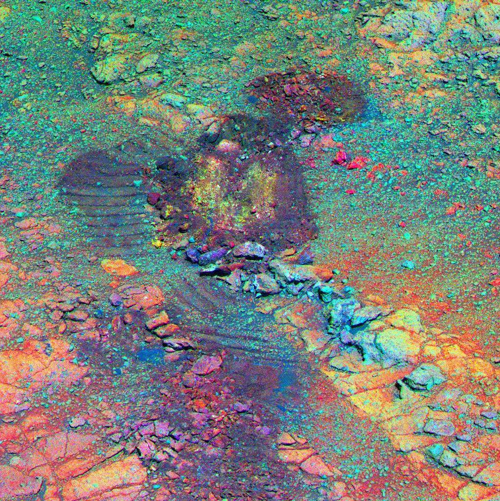
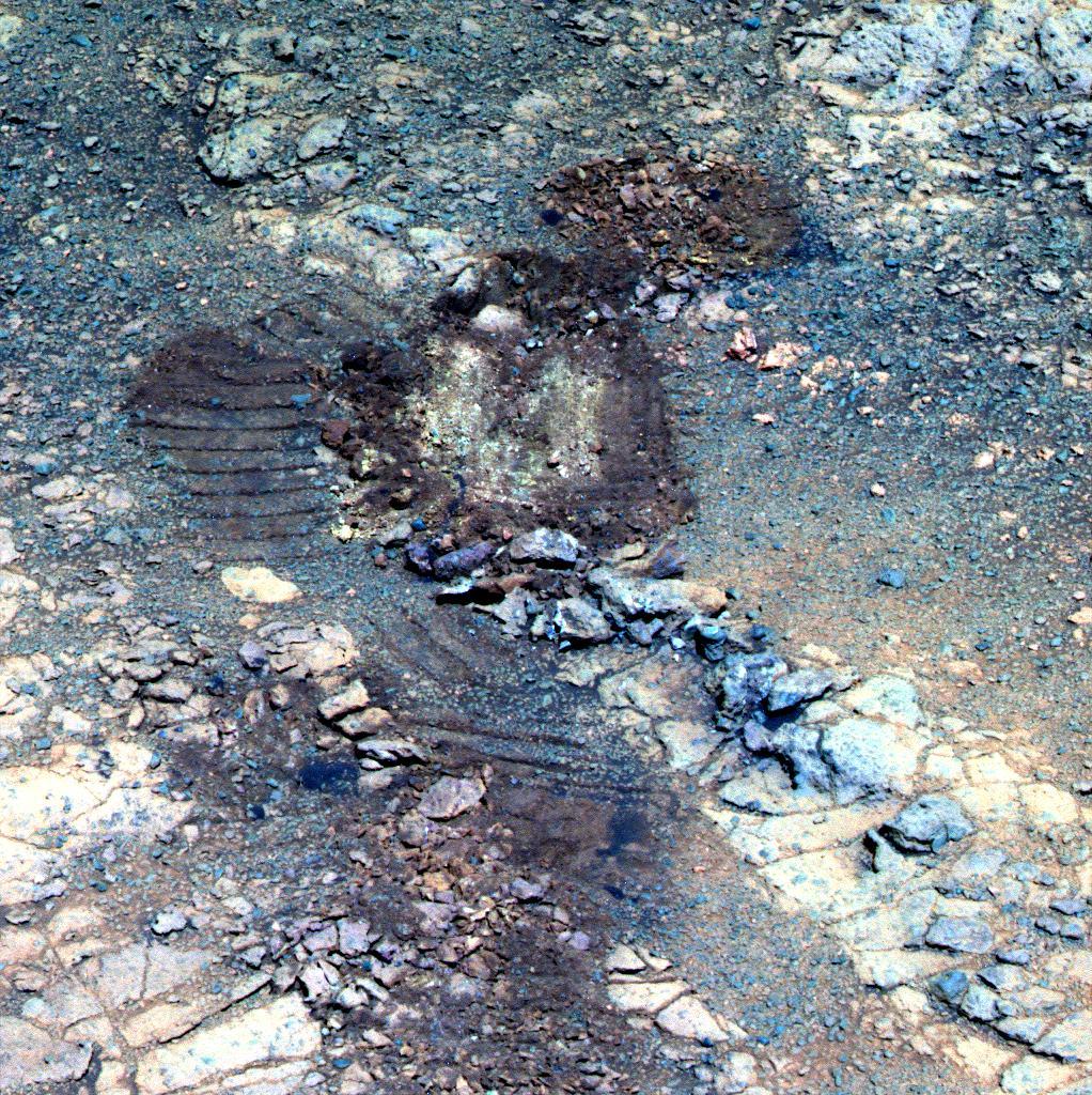
Decorrelating the scuff
Opportunity took this image of the “red zone” that she scuffed up in May using the 13 Pancam filters devoted to geologic materials. From those data, Bill Farrand, Senior Research Scientist at the Space Science Institute and member of the MER science team, conducted a decorrelation stretch of the images and produced this version. This technique exaggerates the colors making it easier for scientists to distinguish features. “You can see colors that pop out,” noted Farrand, whose work helped the team decide which pebbles the rover should look at up close.NASA / JPL-Caltech / Cornell / ASU / W. Farrand, SSI
Instead, Marathon Valley offered them a story that “turned out to be interesting, but is different than the one we were hoping for,” Squyres said. “We've come to learn that while a clay signature [from orbit] gives you a good hint that a place is going to be interesting, it doesn't provide you with deep insight into what you're actually going to find when you get there. Most of what you learn is after you get there and begin geologizing yourself with the rover.”
The MER scientists found that the residue of ancient iron magnesium clays are spread all over the place, in and around the breccia bedrock that was hurled up and formed at the time the impact created Endeavour some billions of years ago. This breccia, which the team calls Shoemaker Formation, is familiar. Opportunity has been driving on, through, and around it for almost her entire mission.
“A key thing we found is that the rocks that show the iron magnesium smectite signature, whether from orbit or from the ground with Curiosity and CheMin (Chemistry & Mineralogy), each suggest mild alteration by water,” said Arvidson. “This is consistent with what we saw at Matijevic Hill, and actually with everything that Curiosity has seen.” [At Gale Crater, Curiosity is driving on ancient river and lake and delta deposits. “So there was a lot of water there in the past,” he said, “but not a lot of aqueous alteration except in the fractures.”]
The findings in Marathon Valley suggest that during and after the impact there wasn't all that much water coming up as high above the crater floor as where Opportunity is located, except through the cracks...where water once found a way to surface.
Even before the rover drove into Marathon Valley, she sent home images that revealed the presence of deep red bands or troughs, “red zones,” as the team dubbed them, at places along the rim of the small Spirit of St. Louis Crater at the valley’s entranceway. Then, when Opportunity pulled into Marathon Valley, she saw red zones all over the valley floor and along the valley's southern wall flank. Since last October, the solar-powered robot has been positioned on north-facing slopes on the valley’s south wall, angling herself and her solar winglets toward the Sun in the northern sky, to take in as much sunlight as possible during the winter while she studied rocks and red bands.
Based on the visual appearance of the red zones and the deep red color of the soils and pebbles they hold in their mix, the scientists almost immediately surmised that these linear, winding features are ancient fractures where water would preferentially tend to flow. "Fractures running through the bedrock, forming conduits through which water could flow and transport soluble materials, could alter the rock and create the pattern of red bands that we see," said Squyres.
When the science started coming in, some confirmation began to follow. “This is where we see leeching and deposition of other minerals, probably associated with extensive water flow,” Arvidson said. Wherever they found the red zones though, they were composed of fragmented material, “a jumble” of stuff, so much so it was impossible to know where it all came from and difficult to adequately study. “We kept looking and kept looking for bedrock and not finding it,” Squyres said.
Opportunity ascended as high as she could up Knudsen Ridge, nearly to the top, trying to reach some in-place bedrock. It was a futile effort, and who knows how much it might have changed the story. But it is what it was and everyplace else the rover looked was the same.
“All we were finding was dirt, reddish dirt,” said Squyres. “What we didn't realize until we took a close-enough look is that this stuff has been so pervasively altered, it's not bedrock. There's no solid bedrock the rover could grind with the RAT [Rock Abrasion Tool]. It's all crumbly crud now.”

Two more years!
Opportunity is there, on Mars, right now, heading into her 10th mission extension since scoring the world’s first interplanetary hole-in-one in January 2004. In May, Earth and Mars orbited closer to each other than at any time in the last decade. On May 12, 2016, the Hubble Space Telescope (HST) captured this image. Mars’s closest approach to Earth occurred May 30th, at 21:36 UTC, when the planet was 75.28 million kilometers (46.77 million miles) from Earth.NASA / ESA / HST
Whether by accident or happenstance or whether by intent, Opportunity and her twin, Spirit, have shown that it’s worth scuffing things up once in a while. In May, the rover was commanded to drag her left front wheel through one of the red zones. Just like when Spirit dragged her broken left front wheel and churned up near pure silica around Home Plate, “we found these really interesting altered materials just below the surface in this scuff of Opportunity’s at Marathon Valley,” said Bill Farrand, Senior Research Scientist at the Space Science Institute, and member of the MER science team.
Farrand’s work with the Pancam multispectral images the rover took helped the team determine which little pebbles inside the trenched area Opportunity should look at up close. That work guided them to a couple of ‘gems.’
"In the scuff, we found one of the highest sulfur contents that's been seen anywhere on Mars,” said Squyres. “There's strong evidence that, among other things, these altered zones have a lot of magnesium sulfate. We don't think these altered zones are where the clay is, but magnesium sulfate is something you would expect to find precipitating from water.”
The scientists found no signs of the smectites or clays of any kind in the jumbles of red zones. But they did get a story they hadn’t come looking for. “The story,” chuckled Squyres, “is in the crumbly crud.”
So the mission may not have uncovered a mind-blowing, can-you-believe-this story at this much-anticipated location, but what the robot field geologist did find in Marathon Valley adds to the global story of water on Mars, as well as the past environments in which iron magnesium clay minerals formed. In the end, the take-home science from Marathon Valley is “telling us more about the overall history of Mars and action within the fractures,” said Arvidson.
The low water-to-rock ratio findings don’t threaten the theory that Mars was once more like Earth, with lakes, rivers, perhaps even an ocean, though they may alter the picture of Mars’ ancient, more Earth-like environments. “There is water and ice and mechanical transport and some degree of chemical alteration,” said Arvidson, “but it's not balmy Cuba we’re talking about here, more like Greenland.”
Opportunity’s next adventure will take the world on an expedition over the Martian hills and dales of Endeavour’s western rim on the never-ending quest to time travel back in geological Martian history, even as it cruises into the future of the next two years. And it will begin soon.
“Before long, we'll drive away, Squyres assured.
Once the robot field geologist finishes investigations into a rock or two on the floor of Marathon Valley and fills in the blanks in the extensive imaging of the valley’s north wall, an assignment the rover began upon entering the valley about a year ago, the sciencewerks in the valley should be wrapped. And after that: “‘Poof!’ We're out of Marathon Valley, and heading to points south and further into the rim,” said Arvidson.
The exit plan so far will have the rover drive around the southern wall of the valley and head southeast, downhill along the rim at Cape Tribulation. While Squyres won’t commit to exactly when the rover will pull out, the scuttlebutt is, if all goes well, Opportunity could be on the crater rim road in August.
“We have some stuff in this next plan that no rover has ever done before,” Squyres hinted previously. From the looks of the paths through Cape Tribulation, the steep slopes and treacherous turns may only be a glimpse of what some of that stuff will be. “The road,” he said, “winds a lot.”
NASA / JPL-Caltech / Cornell / Arizona State University
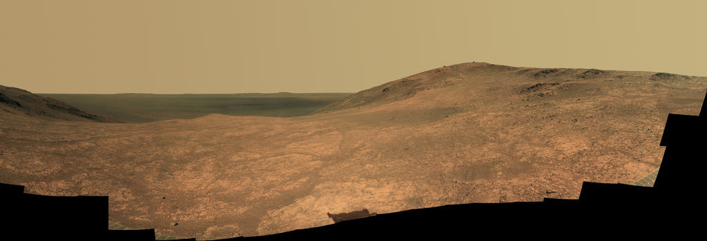
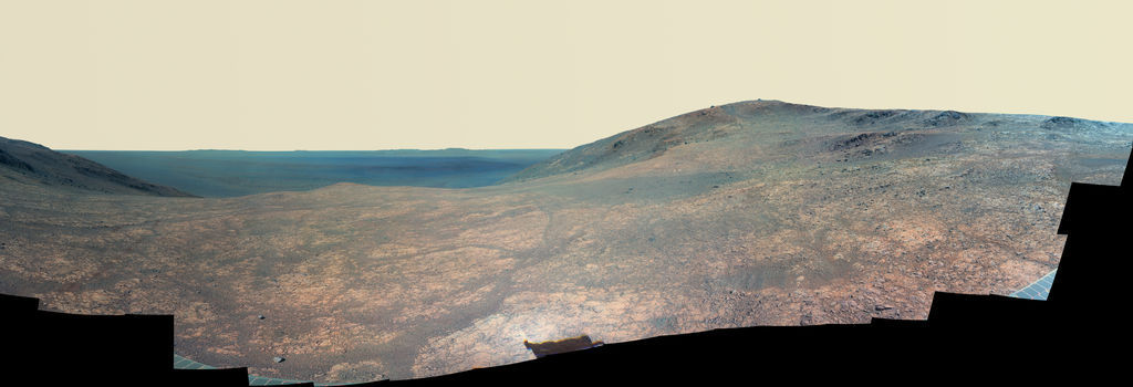
Marathon Valley
Opportunity used her Panoramic Camera (Pancam) to take dozens of images from April 16 through May 15, 2016 (Sols 4347 through 4375) that went into this panorama of Marathon Valley. The view is to the northeast toward the floor of Endeavour Crater, which is 22 kilometers (13.7 miles) in diameter. The high point in the right half of the panorama is Knudsen Ridge, part of the south ‘wall’ of the valley. Kelsie Crawford, a Pancam calibration analyst and undergrad in Astrophysics and Physics at Arizona State University, merged the exposures taken through three of the Pancam's color filters, centered on wavelengths of 753 nanometers (near-infrared), 535 nanometers (green) and 432 nanometers (violet) and created a near final mosaic for Planetary Society President and Pancam science lead Jim Bell to “polish.” This is approximately true color.When June dawned at Endeavour, Opportunity was in the midst of an in-depth science campaign in the trench she scuffed up in May. Specifically, the robot field geologist was hunkered down over a tiny ‘yellow’ pebble named Joseph Field, after a member of the Lewis & Clark Expedition.
Her energy was good. With 42.79 kilometers (26.59 miles) on her odometer, Opportunity was utilizing just under 75% of the sunlight hitting her arrays and producing around 640 watt-hours of solar energy, nearly 2/3 her capability after landing with clean solar arrays. The sky overhead was lightly hazy, with atmospheric opacity or Tau registering around 0.566.
These numbers would hover up or down a bit throughout the month, but it would become clear in June that Opportunity had plenty of power to leave the security of the north-facing slopes along Marathon Valley’s south wall. With the Spring Equinox coming up July 4th and the temperatures climbing higher along with the Sun, the rover could theoretically leave her winter haven anytime.
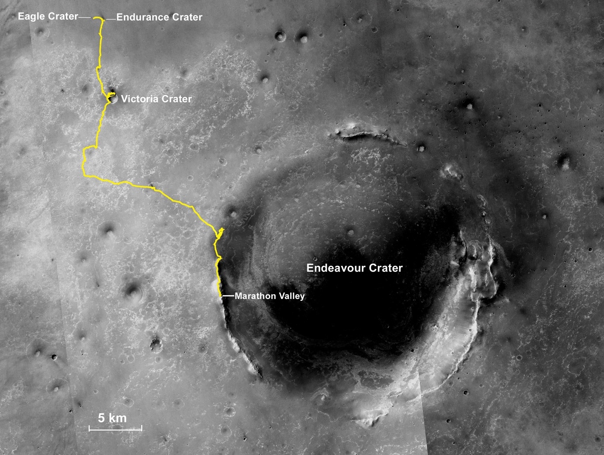
Oppy’s expedition so far
The gold line on this image shows Opportunity's route from the Eagle Crater landing site to her approximate current location. Since August 2011, the MER mission has been exploring the western rim of Endeavour Crater and in July the rover entered Marathon Valley. The base image for the map is a mosaic of images taken by the Context Camera onboard the Mars Reconnaissance Orbiter (MRO). Larry Crumpler, of the New Mexico Museum of Natural History and Science, provided the route add-on.NASA /JPL-Caltech / MSSS / NMMNHS
During the first week of the month, Opportunity spent her most of her science time on the tiny yellow pebble, trying to analyze its chemical makeup. Although Field might take on a washed-out yellowish hue if you were standing in the rusty redness of the landscape, in the multispectral image of the scuff that Farrand processed, it popped yellow, because of the reflectance properties of its make-up.
The rovers’ Pancams endeared themselves to the world from the beginning with the first magnificent high-resolution, color images of rocks and craters and hills and panorama landscapes of Mars that have become a hallmark of the MER mission, that have transformed the Red Planet into a familiar planetary neighbor.
The MER rovers were designed to robotically simulate a human field geologist so Spirit and Opportunity were given features that allowed them to look out over the landscape as you or I would. The Pancam cameras, positioned at about 5 feet off the ground on the rover’s mast, are the robot field geologist’s eyes. They can image a scene in 360-degrees and they sport 20/20 vision. But they are robots and as such they were also equipped with some super-vision.
The appearance of most rocks and soils and surfaces on Mars would be fairly bland, monotonous in shades of rusty red, so planetary scientists use color to aid in directing the rover’s field work and in understanding it. Beyond those stunning color panoramas, the Pancam can collect 13 filter geology observations using 11 spectrally distinct channels (with overlapping spectral coverage in the red and blue) to provide information on the composition of surface materials based on the way they reflect light.
Therefore, with the Pancam Opportunity can see and capture light from frequencies objects and geological features in multiple spectra or wavelengths, including some beyond the visible light range for us humans, like infrared.
This multispectral imaging capability is an invaluable asset aiding the scientists in considerable ways these days, especially since the rover’s most diagnostic mineral detectors, the Miniature Thermal Emission Spectrometer, and the iron sniffing Mössbauer Spectrometer, are no long functioning.
Multispectral imaging can help scientists glean additional information the human eye fails to capture with its red, green, and blue receptors. With images taken at wavelengths beyond the range of human vision, scientists can, for example, learn more about the minerals found in Martian rocks and soils. Some rocks and soils the rovers have checked out have multispectral reflectance spectra that resemble those of known minerals measured in terrestrial laboratories and stored in “spectral libraries.” Therefore multispectral images enable scientists to identify the mineralogic composition of rocks and soils they study by assessing their color properties and reflectance signatures.

Field up close
Opportunity took the images for this mosaicked close-up with the Microscopic Imager (MI) on her Sol 4389 (May 29, 2016). This raw frame shows a tiny portion of the area the rover scuffed up a few weeks earlier. The bright chunk at the bottom is the target named Joseph Field, after a member of the Lewis & Clark Expedition. The rover studied the area through the first half of June.NASA / JPL-Caltech
“We use this information to look for interesting materials or spectrally unique materials,” said Farrand, who has a deep background in working with multispectral and the higher spectral “hyperspectral” image data over both terrestrial and Martian surfaces.
“Bill took the Pancam 13-filter data and retrieved the reflectance of this pebble, and said, 'Boy this one is unusual –,’” recalled Arvidson. “That led to us going back to that spot.”
Once the Pancam’s 13-filter image of Opportunity’s scuffed trench arrived on Earth, Farrand made “a simple color composite,” using filters at 673, 535, and 432 nanometers, and then did “a decorrelation stretch,” he said during a recent interview. Decorrelation stretching enhances the color separation of an image with significant band-to-band correlation. These exaggerated colors help the scientists visually interpret and better discriminate features and elements in the scene.
In that decorrelation stretch of the scuff, Field stood out bright, in a shade of Here-Comes-the-Sun yellow. Farrand then compared the reflectance of Field with those in the terrestrial spectral library database on Earth as well as those Mars scientists have acquired.
In modeling the scuffed area, he found that the 11 point spectra of Field collected by the Pancam was spectrally similar to iron sulfate bearing soils Spirit found in the Columbia Hills. And Spirit’s finding was confirmed then with the Mössbauer Spectrometer. “That's why I suggested this pebble would be a good target to look at with the APXS and probably would be rich in iron sulfates,” Farrand said.
Opportunity spent most of the first week of June working on Field, conducting a series of offset integrations on the tiny yellow pebble with her APXS. The objective, of course, was to gather enough data to tease out the pebble’s chemical make-up as compared to the composition of the soils in the background.
The rover offset her APXS again on Sol 4395 (June 4, 2016) and placed it on the chosen spot for a multi-hour integration. The next sol, Opportunity took the pictures needed for a Microscopic Imager (MI) mosaic, and after that she moved her APXS just a bit for another offset integration. In between taking the routine MIs and APXS integrations on, the rover also took multi-color panoramic images of her surroundings and handled all the routine chores and tasks that are a part of life as a robot on Mars.
NASA / JPL-Caltech / University of Arizona
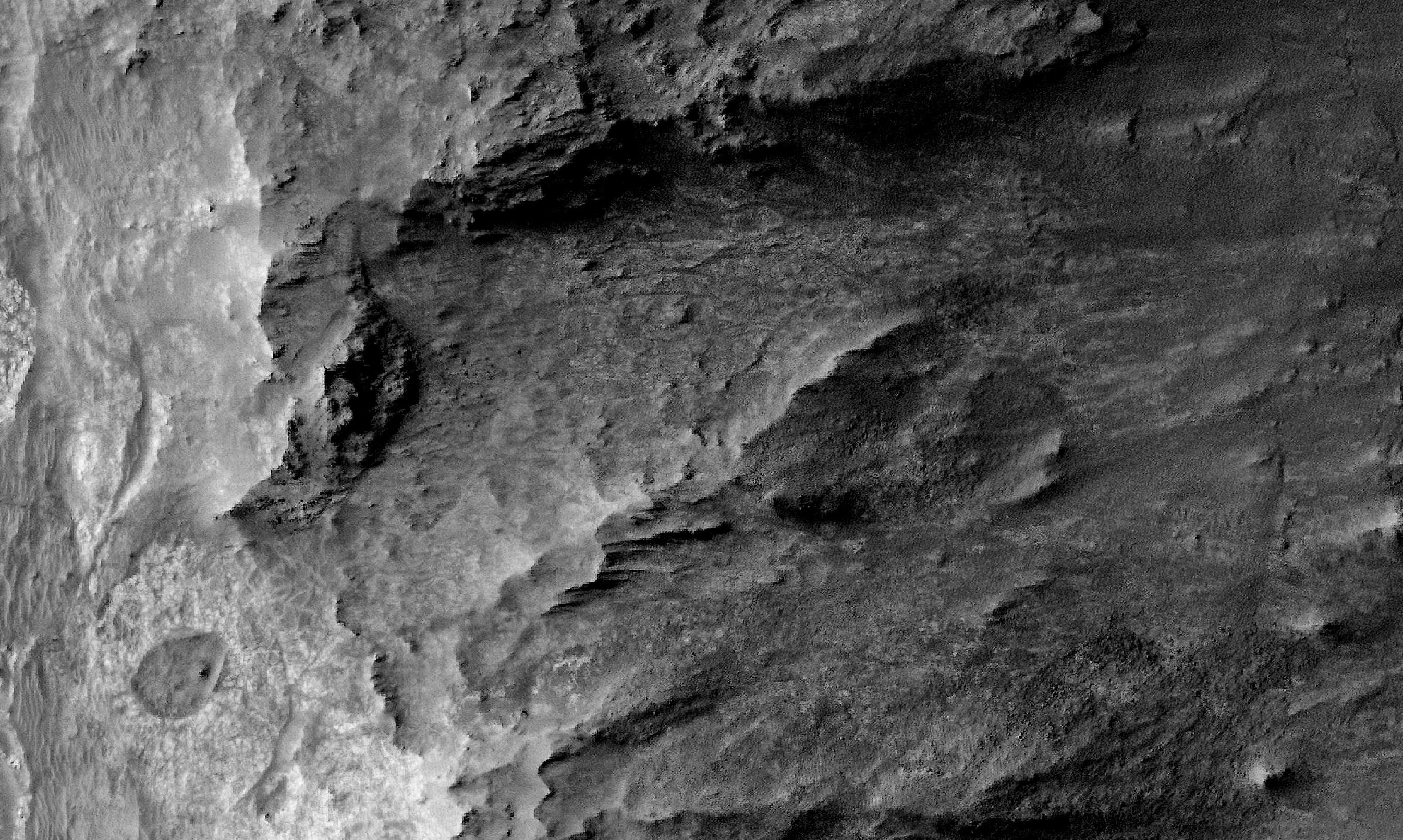
Marathon Valley from above
The HiRISE camera onboard the Mars Reconnaissance Orbiter took this overhead image of Marathon Valley. Opportunity entered the valley in July 2015, after studying Spirit of St. Louis Crater, visible in lower left of image. The valley stretches west to east (left to right in image) about 330 meters (1100 feet) cutting into the 22-kilometer (13.7- mile) diameter Endeavour Crater (to the right and off image).By the end of the first week of June, Opportunity’s Fieldwork was done. There is more to be done on Earth, “like pulling apart the signal to isolate what exactly is coming from the pebble,” noted Arvidson. However, the data in hand have already borne out Farrand’s notion that iron sulfates, and likely additional sulfate minerals are present in Joseph Field and other subsurface soils in that location.
Moving on, Opportunity bumped 10 centimeters (about 4 inches) to a new pebble of interest on Sol 4398 (June 7, 2016). The rover would spend the second week of June investigating this red pebble the team named for named George Drouillard, a civilian interpreter, scout, hunter, and cartographer for the Lewis & Clark Expedition.
Following the routine science protocol, the robot took pictures of the target with her MI for a mosaic, and then analyzed its chemistry with the APXS, conducting a 2-sol plan on Sols 4402-4403 (June 11-12, 2016), that included offset APXS placements to help the scientists map out the elemental constituents of the target.

Finding minerals
These images show what scientists can do with the Pancam’s multispectral capabilities. From the 13-filter Pancam pictures that Opportunity took of the trench she scuffed up in May, MER science team member Bill Farrand produced both a false color version (top) and then conducted a “decorrelation” stretch (bottom). This technique enhances colors of rocks and features and enables scientists to better discern geologic materials in a given scene. The Joseph Field target is the yellow pebble (left) that has been boxed; and George Drouillard (right) is circled. Both pebbles, which the rover studied in June, held minerals that spoke of past water.NASA / JPL-Caltech / Cornell / ASU / W. Farrand, SSI
With her work at Drouillard finished, Opportunity bumped back and collected 13-filter images of the work area on Sol 4404 (June 13, 2016), and then bumped farther back, totaling 1.4 meters (4.6 feet). The next sol, 4405 (June 14, 2016), the rover took off, driving 19 meters (62 feet) toward the center of the “CRISM area,” the area on this slope of Marathon Valley’s southern wall where the orbital instrument onboard the Mars Reconnaissance Orbiter (MRO) indicates there is a mother lode of smectite clay minerals. “We call it the Red Square,” said Callas.
“We pretty much have the smectite story here, but we wanted to make sure we got into middle of red pixel area in case anybody asked,” said Arvidson.
On her arrival in the Red Square, Opportunity checked out a couple of bedrock targets in their natural state. The team chose one, called York, and the robot brushed the surface, and then looked at it up-close again.
Meanwhile, on Earth, NASA-JPL issued the MER mission’s newest panorama June 14th in a press release announcing that Opportunity is beginning to wrap up her science campaign at Marathon Valley. Officially the Marathon Valley Panorama – the team calls it the Sacajawea Pan – this image, taken from the entryway where the valley cuts into Endeavour’s western rim, presents a sweeping view looking eastward into the 22-kilometer (13.7-mile) diameter crater.
It is the result of a “solid month’s worth of work,” said Kelsie Crawford, a 19-year-old Physics and Astrophysics student who processed the panorama to near completion from Pancam central at Arizona State University (ASU).
With five active missions at Mars and others in development or waiting in the wings (not to mention other planetary missions ongoing), many members of the MER team are working multiple missions. As a result, the veteran missions have become valuable training grounds for students and when it comes to real time planetary exploration education, MER is Ivy League.
Pancam operations moved to ASU when Planetary Society President and Pancam lead scientist Jim Bell took a position as Professor of Astronomy there, relocating from Cornell. Like the robot and all its other instruments, the Pancam needs regular attention. For example, the stereo camera system needs to be calibrated on average three times a week, among other things. Then of course there is a steady stream of images to be processed and so there is plenty of work for the image inclined.
Creating one of the mission’s hallmark high-resolution panoramas, however, takes time and effort that few people understand. Dozens, sometimes hundreds of images go into multiple parts or sections that are ultimately stitched together into the final ‘big picture’ work, and it’s kind of like baking a cake. Every ingredient has to be just right or the final product won’t be.
Crawford was initially hired to work as a Pancam calibration specialist, but with a little help and encouragement from Professor Bell, she expanded her horizons. She began learning the craft of exploration through hands-on experience putting together mosaics from Pancam’s raw images – and long story short, she wound up mosaicking the Sacajawea Pan.
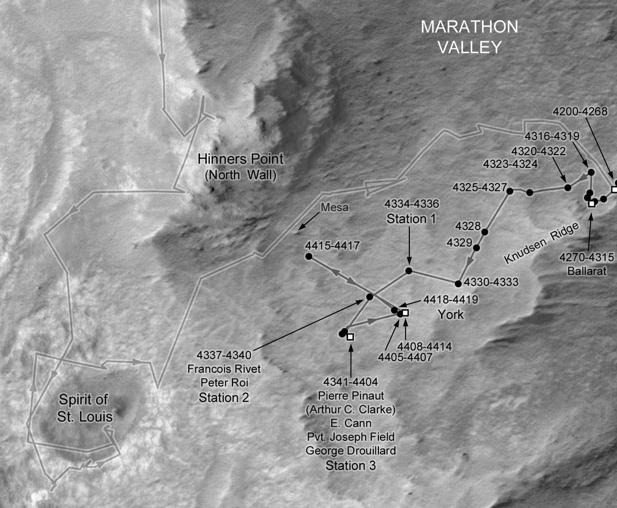
Oppy’s recent roves
This image map of Opportunity's recent rovings and science stops was charted by Phil Stooke, associate professor, University of Western Ontario, Canada, and author of The International Atlas of Mars Exploration Vol. 2, Spirit to Curiosity: 2004 to 2014, Cambridge University Press, 2016. He is also an active member and contributor to UnmannedSpaceFlight.com. The base image was taken by the HiRISE camera onboard MRO.NASA / JPL-Caltech / UA / P. Stooke
“The new pan was 22 parts and comprised of 80+ images in each of the three filters that make the false color image,” Crawford noted. But it’s not like you have all the pieces to a puzzle and you just have to put the puzzle together. For starters, the team has to make sure they get all the images needed for each part or section. That means “every few parts or so, a new mosaic needs to be made so that the people pointing the camera know what has already been covered and what is still missing from the eventual final product,” she said.
Therefore, a lot of her time was spent making new mosaics with the freshest downlinked images, and adjusting each filter afterward to present mosaics as ‘picture perfect” as they could be in the moment. “That way what was being shared with the team didn't look all blocky,” Crawford explained.
Since the images are taken at different times of the Martian day and on different days, the real challenge lies in processing the image without any telltale seams. “Lighting conditions are different for every image, in every filter, and end up needing to be ‘adjusted’ so to decrease visibility of seams to hopefully none,” Crawford said.
Creating the mosaic and adjusting the frames are generally done with programs written for the instrument, but, noted Crawford, “[i]t seems not many people understand how the adjusting program works. To overcome that hurdle, she taught herself how to use the university’s in-house adjusting program and now knows enough to be able to produce a well-adjusted mosaic that “nearly eliminates all seams,” as she put it.
At that point, not long ago, Crawford sent her version of the Sacajawea Pan onto to Bell, who ironed out the last slight signs of seams. Now, you have it.
As the third week of June took hold, Opportunity began work on one of her final in-situ campaigns, inside the Red Square in Marathon Valley. She bumped 25 centimeters (about 9.84 inches) on Sol 4406 (June 15, 2016) to line up for some surface targets, the first of which the team named Jean-Baptiste Deschamps, after another member of the Lewis & Clark Expedition.
The next sol, 4407 (June 16, 2016), Opportunity followed the routine science protocol taking pictures of Deschamps with her MI for a mosaic and then placing the APXS on the spot to determine the bedrock’s chemical composition. After completing the MI and APXS studies of the rock’s natural surface, the team found it was not safely brushable. “So we bumped to close by smoother bedrock target,” said Arvidson.
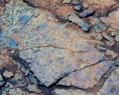
York
Opportunity checked out a rock in the heart of the area where orbital data show a mother lode of smectite clay minerals. The team took to calling this area the Red Square, because the clay signatures are defined by red pixels on the mission’s mineral map. Even so, the MER scientists encountered no surprises at York, no new findings.NASA / JPL-Caltech / Cornell / ASU
On Sol 4408 (June 17, 2016), Opportunity turned and moved just 43 centimeters (16.92 inches) to line up with the next nearby target, dubbed York. Then, the robot took care of some routine business, checking the Tau and calibrating the MI with some 'sky flat' images.
During the next two sols, 4409-4410 (June 18-19, 2016), the robot field geologist took a 360-degree Navigation Camera panorama and conducted a 'sky flat' calibration of the Pancam.
Then, on Sol 4411 (June 20, 2016), Opportunity took a close look at York, carrying out the usual science protocol with her MI and APXS. On Sol 4412 (June 21, 2016), the rover used her used the Rock Abrasion Tool (RAT) wire brush to clear the surface of that target and collected another MI mosaic and placed the APXS for another integration. “We completed observations of the target in both natural and brushed,” said Nelson.
On Sol 4414 (June 23, 2016), the rover spent a quiet work sol taking color Pancam images, and some 13-filter Pancam imagery of the worksite. Then, the next sol, 4415 (June 24, 2016), the rover left York with a 36.04-meter (118-foot) drive to the northwest onto the floor of Marathon Valley, not far from an intriguing geological feature that resembles a mesa or tree stump with a flat top surface.
It was around this time that the ground crew realized that the 13-filter Pancam images of the York worksite were not received on the ground, likely, they determined, because of relay bandwidth variability in the downlinking. Fortunately, other Pancam and Navigation Camera (Navcam) images of the north wall of Marathon Valley that were taken were received.
So, on Sol 4418 (June 27, 2016), Opportunity turned around and drove 36 meters back to York to re-take the 13-filter Pancam images of the brushed target. And, as long as she was there, she brushed York with her RAT on Sol 4420 (June 29, 2016) and silently recorded a moment. On that sol, Opportunity doubled the communication time the mission had with Spirit. Her twin that sent her final communiqué from Troy at Home Plate in Gusev Crater, on Sol 2210.
As June turned to July, Opportunity was about to leave York, the Spring Equinox was just around the corner, and life on Mars was still good.
Looking back, the mission’s seventh Martian winter and the science campaign at Marathon Valley, left the team with little to complain about. “It went pretty well,” summed up Callas. “We had decent energy. We did have some challenges being in RAM mode in the deepest parts of the winter, but we worked through that. The vehicle continues to be in excellent health and very productive. We didn't find the 'a-ha smoking gun' for the phyllosilicates, but the science team has completed a great assessment of geology in Marathon Valley and how it plays into the understanding of Endeavour Crater and the history of Mars,” said Callas.
That assessment, in fact, is another piece in the puzzle of the water story at Endeavour, and to some extent Mars at large. “Everything we see in the bedrock in Marathon Valley seems to be Shoemaker breccia with a fine-grained matrix, kind of reddish and that's probably what is carrying the smectite signature,” said Arvidson. “But it hasn't been really leeched a whole lot, so it's more or less the chemistry of basalt, a low water-to-rock ratio that produced the smectites.”
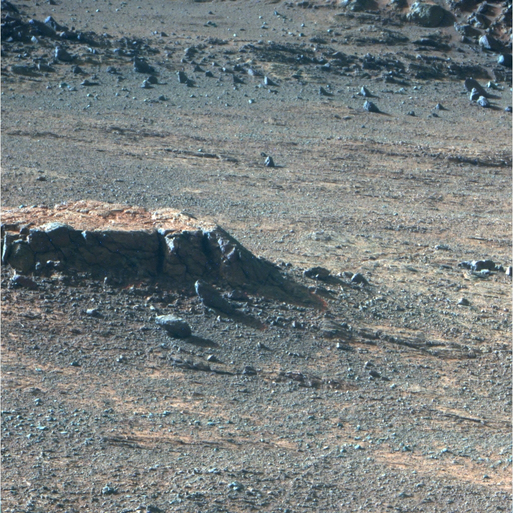
Mesa pequeña
After finishing up at York, Opportunity headed for this small ‘mesa’ on the floor of Marathon Valley when her team discovered the Pancam 13-filter images the rover was assigned to take of York had not made it to Earth in the electronic shipment. So as June wound down, the rover headed back to York, with plans to return to the little mesa during the first week of July.NASA / JPL-Caltech / Cornell / ASU
But the fracture, where Opportunity exposed and investigated pebbles and stuff in the scuff – E. Cann, Joseph Field, and George Drouillard – points to more leeching, more water. “It's a consistent story that goes all the way back to Cape York and Matijevic Hill and Matijevic Formation in that where we are seeing these, iron magnesium smectites from CRISM, from orbit, it represents light alteration. Then we get into the fractures and find evidence for extensive leeching, likely because the fractures have more water going through them.”
Although the hope when Opportunity entered Marathon Valley about one year ago was that the rover would uncover some more Matijevic Formation strata, which the mission first found at Matijevic Hill in 2012, in the end, “we found a very different story here,” said Squyres.
And, an important lesson learned in the process. “The clay signatures pop up in places where there has been some kind of water activity, but they do not uniquely identify what the nature of that water activity was,” he said.
While the CRISM data has certainly proved very useful in guiding the mission to science-rich areas, like a kind of beacon from space, "when you get there, you better expect that you will have a lot of work to do," said Squyres.
The story in Marathon Valley, it turns out, is really in the red bands of highly altered material that crisscross all of Marathon Valley. “What we're seeing at Marathon Valley is a place where erosion has excavated deeply these Shoemaker Formation breccias and we can see the pathways through which the water that altered them flowed,” said Squyres. “We believe these are alteration zones, that these fractures serve as paths of weakness where the water can come up from the subsurface and flow, altering stuff as it goes. There is precipitation of a lot of different minerals, including, at one point we looked at in the scuff, we found very high concentrations of magnesium sulfate which is one of the minerals you would expect to be precipitated from water.”
The Shoemaker breccia that Opportunity examined in Marathon Valley may be “deeper Shoemaker Formation than we've seen elsewhere,” said Squyres. “But we have not at this location seen any of the Matijevic Formation bedrock. That is something we will go off and search for elsewhere.”
“Matijevic Formation strata presumably represents the original Mars bedrock before the impact event,” said Arvidson. “It should be stratigraphically and topographically lower than where we are now.”
“The Matijevic Formation rocks we found on Matijevic Hill were among the most interesting on the entire mission with either rover,” added Squyres. “They are unquestionably the oldest rocks we've ever seen with Opportunity and may be the oldest rocks any rover has ever seen on Mars...and they left us with a lot of questions unanswered. Finding more Matijevic Formation is one of our highest priority objectives.
NASA / JPL-Caltech / Cornell / Arizona State University
Unreal view
The above image is a false color version of the MER mission’s latest panorama, a view through Marathon Valley, which garnered its name because the rover’s arrival in this area along the western rim of Endeavour Crater coincided with her completion of the first marathon on another planet beyond Earth. Opportunity first entered the valley in July 2015. The rover team calls this the mission's Sacajawea Panorama, in honor of the Lemhi Shoshone woman, whose assistance to the Lewis & Clark Expedition helped enable its successes in 1804-1806. Team members named many of the rocks and other features in Marathon Valley for members of the expedition officially known as the Corps of Discovery. This image was processed by Kelsie Crawford and Jim Bell, of ASU.Protect Our Shared Future
You help us defend humanity and prevent asteroid impacts. Donate now to become a Planetary Defender!
Donate