
 Explore Worlds
 Find Life
 Defend Earth


Mars Exploration Rovers Update: Opportunity Digs Marathon Valley Walkabout
Sols 4096 - 4125

Written by
A.J.S. Rayl
Contributing Editor, The Planetary Society
September 3, 2015
Mars Exploration Rover
NASA / JPL-Caltech / Maas Digital
Opportunity drove farther into Marathon Valley in August, dug into what appears to be a water-altered rock, and took a lot of picture postcards in what is turning out to be a distinctively different site from any that the Mars Exploration Rovers mission has found since the robot field geologist landed in 2004.
"It’s a place that’s unique relative to where we’ve been before," said Ray Arvidson, MER deputy principal investigator, of Washington University St. Louis. "This is virgin territory for us."
The veteran rover is currently within the central unit of Marathon Valley, which cuts into the 22-kilometer (13.7-mile) diameter Endeavour Crater from its western side. As Opportunity is exploring the valley, which extends about 250 meters east-west for about 100 meters north-south, the MER team is slowly beginning to write a new chapter in the story of Mars' ancient past from this puzzling new clayground.
Opportunity entered the Marathon Valley last month and is in the midst of a geological walkabout to see what's there. "The objective is to cover the whole territory pretty comprehensively before winter sets in later this year," said Steve Squyres, MER principal investigator, of Cornell University. But Marathon Valley is a lot bigger than Matijevic Hill, where the mission made history in 2013 ground-truthing the first clay minerals found by a surface mission on Mars. "So this walkabout will take time," he said.
"The rover is doing exactly what Steve or I would do if we were there in the field in space suits," said Arvidson. In August that translated to the rover taking Panoramic Camera (Pancam) images of the valley's north wall and spending a lot of time examining and grinding into a flat, light-toned rock named Private Robert Frazer, after a member of the Corps of Discovery, more popularly known as the Lewis & Clark Expedition.
Although the MER scientists believe that Frazer is impact breccia, rock formed of various fragments of older rocks melded together presumably during the event that created Endeavour Crater 3 to 4 billion years ago, the team has scientific reason to believe its chemical composition will show it was altered by a lot of water, like the breccia rocks the robot has investigated in and just outside Marathon Valley at Spirit of St. Louis Crater.
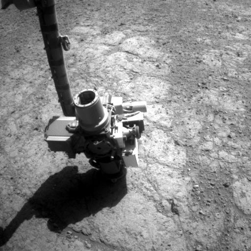
Examining Pvt. Frazer
Opportunity spent the month of August at Private Robert, a rock target named for a member of the Corps of Discovery, more popularly known as the Lewis & Clark Expedition. The rover took this raw image with her front Hazard Camera (Hazcam) on her Sol 4112 (Aug. 20, 2015).NASA / JPL-Caltech
The MER mission's primary science objective in Marathon Valley is to characterize the locations of the different kinds of smectite clay minerals that first lit up the screens of the Compact Reconnaissance Imaging Spectrometer for Mars (CRISM) in 2009. The orbital instrument, which is onboard the Mars Reconnaissance Orbiter (MRO), is searching for signs of past and present water. Smectite clays, which are in a class of minerals known as phyllosilicates that form in neutral to high pH or alkaline water, are sure signs that water much like we drink on Earth once flowed through the valley.
Of all CRISM's detections of clay minerals along the Endeavour Crater's western rim, some of the strongest signatures of smectites have been detected in Marathon Valley. Since the orbital spectrometer already discovered the clay minerals, Opportunity's goal is to examine the clay remnants in their natural context, just like she did on Matijevic Hill, describing the environment in which they are found and how they are situated with respect to other minerals and the valley's geological layers.
Finding and characterizing the various smectites that are in Marathon Valley will help the scientists add to the story of the ancient, watery environment once present billions of years ago at Endeavour. But so far the clay mineral remnants have been elusive, even though the MER team knows the smectites are there.
After acquiring additional detailed data from the orbital instrument, Arvidson, who is also a co-investigator on CRISM, produced a more precise clay mineral map of Marathon Valley, just like he did in 2012 when Opportunity was exploring Cape York. The map of Cape York is what enabled the team to zero in on the "sweet spot" of Matijevic Hill. From that hill, the robot field geologist sent home science gold, becoming the first surface mission on the Red Planet to ground-truth the presence of clay minerals on Mars, as well as the first to uncover the most ancient, Noachian Period bedrock, defined now as Matijevic Formation.
While Opportunity's own mineral detectors, the Miniature Thermal Emission Spectrometer (Mini-TES) and the iron-sniffing Mössbauer Spectrometer, are no longer detecting minerals, the MER team is effectively using CRISM to guide it. Arvidson's pixel-by-pixel mineral map of Marathon Valley pretty much shows exactly where CRISM picked up the signatures of various smectite clay minerals and the MER team utilized it to determine the waypoints on the rover's clockwise walkabout around the valley.
Still, the robot field geologist has yet to rove upon any Matijevic Formation rocks or tiny spherules or concretions known as newberries that it found on Matijevic Hill. And the MER scientists have not yet been able to definitively identify any clay mineral remnants. But the clay minerals are definitely there.
"There’s no way five overlapping observations that show the same thing at the same place are wrong," said Arvidson. "The smectite signature is all across the valley floor, which is unlike anything we’ve seen before. But it is going to take a lot of detective work to put all of this together."
"We really don't understand what we’re looking at in Marathon Valley yet and that’s pretty normal," said Squyres. "You pull into some place that looks different from where you've been before, and you kind of scratch away at it, look around and move around and slowly piece together a picture. In the images we are seeing strange patterns of bright and dark zones and different colors on the ground, and we get a sense that this is a place where there has been some significant alterations and fluid moving through and changing things around chemically. But this is a complicated one."
The MER scientists found Private Robert Frazer interesting enough to command the rover to fire up her Rock Abrasion Tool (RAT) and grind into the flat, light-toned bedrock. It was the first time the robot used her RAT to 'dig in' to a rock since Black Shoulder in Ray's Box near Solander Point, about two years ago.
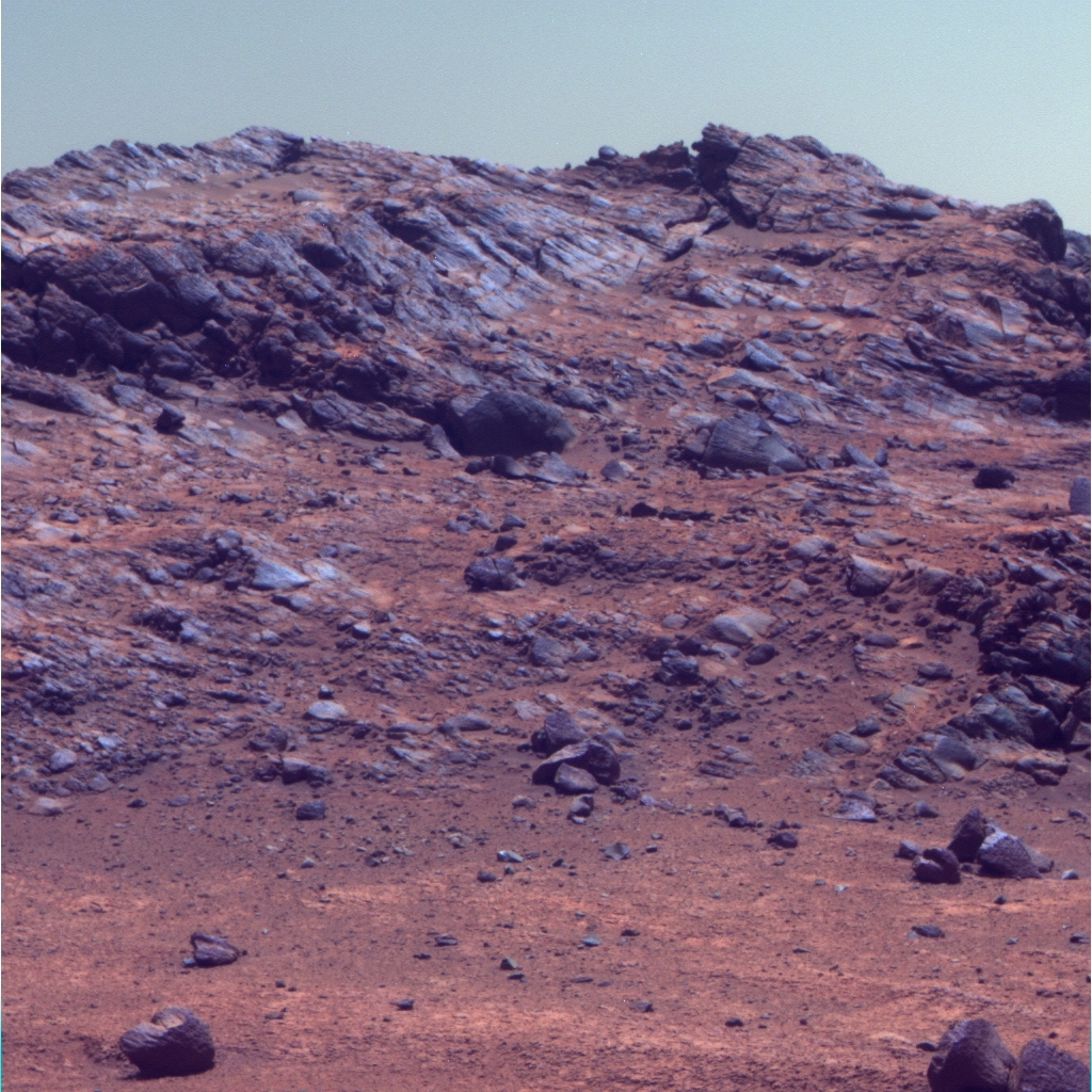
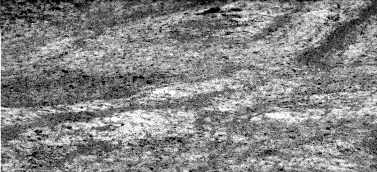
A glimpse of the north wall
Opportunity took this image, which shows part of Marathon Valley's north wall, with the Panoramic Camera (Pancam) on her Sol 4108 (Aug. 14 2015). The Pancam team processed it in false color, a technique that enables scientists to better distinguish the layers and various other geological elements.NASA / JPL-Caltech / Cornell / ASU
Despite the scientists' certainty that Private Robert Frazer is breccia – like Private Reubin Field, the rock that the robot examined in July shortly after driving into Marathon Valley – it is texturally different. Where Field is fine-grained, Frazer features "little rounded clasts" or rock fragments, said Arvidson, who noted that the team is still looking at the data to determine what that might mean.
While temperatures continued to trend scorching hot in the northern hemisphere on Earth, the freeze of fall was dropping temperatures in the southern hemisphere of Mars where Opportunity is exploring. As a result, the solar-powered robot began experiencing the normal seasonal decline in energy production. Nevertheless, the rover is still showing plenty of her MER mettle.
"Opportunity's performance continues to be excellent," said Bill Nelson, chief of MER engineering at the Jet Propulsion Laboratory (JPL), at month's end, as the rover headed farther into the valley to her next target. Named Private Silas Goodrich, this target may be a possible alteration zone along a fracture.
A couple of issues with the rover's parts, however, continue to be investigated. A team of current and former MER software engineers is still working on Opportunity's errant flash storage system or long-term memory, the non-volatile memory that retains data even when power is turned off overnight or when the robot shuts down to take a nap.
There was talk in August of having Opportunity turn on flash again to see if she can make use of it, but John Callas, MER project manager, of JPL, put it off for at least a week. "With the Labor Day holiday, it complicates the planning this week and we want to do some important science" [at Goodrich], he said. "We don't want it to interfere with that."
So, for the time being, Opportunity will continue to store all data in her random-access memory and work in what the mission has defined as persistent RAM mode. Since RAM is volatile memory that only retains data while power is on, the robot must uplink all data to Mars Odyssey or MRO before she takes a nap or goes to sleep. If she doesn't, the data won't be there when she wakes up.
The coming Martian winter will be the veteran rover's seventh winter – beyond impressive, beyond stupendous for a robot initially sent on a 90-day mission. Unlike previous Martian winters however, this one will be challenging, not because of the temperature or dust, but because the rover will likely continue to work in persistent RAM mode throughout most, if not all of the harsh season.
Historically, Opportunity has been able to save energy during the Martian winters by taking naps between assignments. "We won’t be able to do that this winter," said Jennifer Herman, the MER power team lead and a subsystem engineer at JPL.
Herman is not worried about Opportunity's survival, yet there are many 'moving parts' that factor into her job of projecting power capabilities for Martian winters – dust in the atmosphere, the amount of dust on the solar powered rover's arrays, the way-below-freezing temperature during winter, and the increased energy requirements of the rover heaters among them. And because, just like Earth winters, the days are shorter and nights are longer during Martian winters, the rover's position on the ground and its capability of angling its solar arrays toward the Sun throughout the season to soak up as much sunlight as possible must also be taken into account.
Another compounding factor that has an important influence, Herman pointed out, is Mars’ orbit. "It's more elliptical than Earth’s and it just so happens that aphelion [the farther a planet is from the Sun during its orbit] is very close to our winter," she said.

Mars orbit
This schematic shows Mars' elliptical orbit around the Sun. Although the ellipticity of the orbit has been exaggerated for clarity, it clearly shows that aphelion, the point at which Mars is farthest from the Sun, is around solar longitude 70 (LS70), close to Opportunity's winter, which is solar longitude 90 (LS90). Stephen Lewis, of The Open University in the U.K., produced this schematic. It was originally published as Figure 8 in his journal article, "Modelling the Martian Atmosphere," in Astronomy and Geophysics, 44, 4.06- 4.14, 2003.S.R. Lewis, Astronomy and Geophysics
While some of these factors are "the same or slightly better" for this winter than the previous three Martian winters, the 'wrinkle' of Opportunity likely having to rely on her RAM for storing data throughout the season is new. "Now that we’re in RAM mode instead of flash mode, we’re having a harder time recharging the batteries," Herman said. "Keeping everything on requires more energy than if the rover was able to nap. So our energy requirements have increased significantly."
That noted, Herman said that Opportunity should have enough power to rove around the north-facing slopes at the southern end of Marathon Valley through the winter. "It will just take careful operations planning like we usually do," she said. "However, it is requiring us to come up with new workarounds and new tricks," she added.
Those new workarounds and tricks include pushing the rover's normal data uplink time to Mars Odyssey (the orbiter the mission has relied on since the beginning) to a later time, and adding additional downlinks with MRO, because they are earlier than Odyssey downlinks. Later uplinks and earlier downlinks will reduce the RAM mode energy requirements this winter and both of these workarounds have been initiated, according to Nelson.
The prospects, all things considered, are relatively bright for the veteran rover's seventh Martian winter. And, like just about any challenging situation, things could be worse. Consider that when Opportunity and her twin, Spirit, were designed RAM mode was put into the flight software for test purposes on the ground. "We never anticipated using it in flight, and as it turns out, the rover actually can get a lot done in RAM mode," said Squyres. "We've got to be pretty smart about day management, but once we squeeze out all the little efficiencies we can find, the rover can really do quite well in RAM mode."
Actually, the rover has been rocking RAM. "We’ve been getting some spectacular images lately and it’s going surprisingly well," Squyres said.
Beyond flash, the only other issue the MER team is confronting is an anomaly with Oppy's Panoramic Camera (Pancam). "We noticed that a few times over the past hundred sols or so that a Pancam late afternoon sequence would time out and not run to completion, without any obvious explanation," said Jim Bell, the Pancam lead and President of The Planetary Society. "We've got a variety of hypotheses for why this is occurring, but no smoking gun yet."
Although Bell and the team decided to put off any late afternoon Pancam imaging, after working through some details, they are now convinced that the timeout poses no danger to the cameras or to the rover, So, they are planning to resume some limited late afternoon observations and try to diagnose the potential problem more closely with enhanced telemetry from the rover during those imaging sessions, he said.
Despite the challenges, the robot field geologist continues roving up to the plate, so to speak, and Mars and Marathon Valley seem to be on her side. During the next few months, Opportunity is slated to rove around to the southern end of the valley where extensive exposures of highly fractured bedrock and winter friendly, north-facing slopes should enable the robot field geologist to be active and productive throughout her seventh Martian winter.

NASA / JPL-Caltech / University of Arizona
Marathon Valley overhead
This image, taken by the HiRISE camera onboard MRO, shows Marathon Valley, which stretches about 330 meters (1100 feet) into the 22-kilometer (13.7-mile) diameter Endeavour Crater (unseen to the right). Spirit of St. Louis Crater is visible in the lower left of image; the round dark spot inside it, right side, is Lindbergh Mound.Opportunity drove into August, heading east from Private Reubin Field on Sol 4096 (August 1, 2015) and venturing 18 meters (59.05 feet) farther into Marathon Valley. As the rover roved, the MER scientists took in the 'new world' of Marathon Valley's northern wall. "It’s really kind of planar but tilted, and highly fractured, with crisscrossing fractures," said Arvidson. While everything is a rusty red on Mars, "some of the fractures are more red compared to the intervening plates," he said, "so it’s a fascinating area."
The rover drove on for 5.5 meters (18.04 feet) east/northeast on Sol 4098 (August 3, 2015) toward a promising target that she could examine with the instruments on her Instrument Deployment Device (IDD) or robotic arm. The team named the new bedrock Private Robert Frazer. It turned out to be promising enough that the mission would wind up spending the entire month there.
By Sol 4100 (August 5, 2015), the robot field geologist was hunkered down and working on an up-close, in situ examination of Frazer. After taking pictures with her Microscopic Imager (MI) of a chosen spot on the flat, light-toned rock, Opportunity placed her Alpha Particle X-ray Spectrometer (APXS) on the same spot that Martian afternoon to determine its chemical composition.
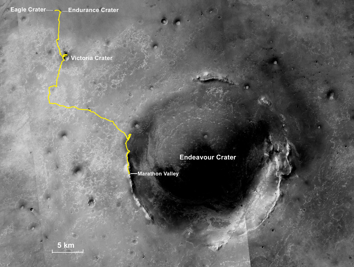
Oppy's long and winding road
The gold line on this image shows Opportunity's route from the Eagle Crater landing site to her approximate current location. Since August 2011, the MER mission has been investigating the western rim of Endeavour Crater, which spans about 22 kilometers (about 13.7 miles) in diameter. The base image for the map is a mosaic of images taken by the Context Camera onboard the Mars Reconnaissance Orbiter (MRO). Larry Crumpler, of the New Mexico Museum of Natural History and Science, provided the route add-on.NASA /JPL-Caltech / MSSS / NMMNHS
As the second week of August got underway, the robot continued her work on the bedrock, moving her IDD slightly to a spot dubbed Private Robert Frazer 2 and beginning what would be a series of offset measurements. After shooting the usual MI pictures for the scientists to create a large mosaic of the chosen spot, the rover placed her APXS for another chemical analysis of the rock on Sol 4103 (August 8, 2015), and then spent the rest of the sol recharging her batteries.
On Sol 4104 (August 9, 2015), Opportunity took pictures with her Navcam, looking in the direction the team planned to drive, and used her Pancam to snap more images of Marathon Valley's north wall. The following sol, 4105 (August 10, 2015), the rover bumped, basically turning to better align her IDD for another chosen spot on Frazer.
The robot field geologist spent her Sol 4106 (August 11, 2015) taking more Navcam drive direction images, as well as more Pancam images of the valley's north wall, an assignment that has been difficult. "We’re interested in the north wall and getting images that will show the contact between the bright floor rock and all the tilted rocks on the wall," said Arvidson. "It’s been hard to do, because the rover has to shoot in the morning because of the Sun angle, and then stay awake all day until the data can be linked through its UHF to Mars Odyssey for transmission to Earth. That’s a real energy hog."
Opportunity pressed on. On Sol 4107 (August 13, 2015), the robot pulled out her RAT to brush what would be the third surface target on the flat, light-toned rock, labeled Private Robert Frazer 3. After that, she followed the science protocol and took MI pictures for a mosaic and then placed her APXS on the spot to determine if the chemical composition there differed at all from the previous two targets on the rock.
During the third week of August, the rover took more Pancam images of Marathon Valley's north wall, and then continued with her investigation of Private Robert Frazer on Sol 4110 (August 16, 2015). She took more MI mosaics and conducted another offset placement of the APXS for a multi-hour integration.
The following sol, 4111 (August 17, 2015), Opportunity used her RAT to grind 1 millimeter into the surface of the rock at the Frazer 3 spot. It was the first time the rover had used her RAT to grind into a rock since July 2013 when she ground 3.3 millimeters (about 0.13 inch) deep into Black Shoulder in the Solander Point suburb nicknamed Ray's Box. After the Frazer 3 grind, the rover took some MI pictures to document the 'dig,' and then placed her APXS on the freshly dug spot.
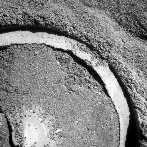
Digging Frazer
The MER scientists found Private Robert Frazer interesting enough to command Opportunity to use her Rock Abrasion Tool (RAT) to grind into the flat, light-toned bedrock. It was the first time the robot used her RAT to 'dig in' to a rock since Black Shoulder in Ray's Box near Solander Point, about two years ago.NASA / JPL-Caltech
Opportunity continued her investigation of Private Robert Frazer on Sol 4112 (August 18, 2015), completing an MI mosaic of the RAT grind, and placing her APXS on a new spot, Frazer 5, for an overnight integration. The APXS data was stored in the instrument's non-volatile memory and the following day, the rover's Sol 4113 (August 19, 2015), the team read out and copied the data into the robot's RAM memory for downlinking later that sol. Then, the rover took a break to fully recharge her battery.
On Sol 4114 (August 20, 2015), Opportunity used her RAT to grind deeper into Frazer 3. This rock must be something that really intrigues the scientists, because the MER team must choose RAT grind targets very, very carefully now that the rover has been on the road for more than eleven and half years. So far, so good.
"The RAT actuators are still healthy as of the Sol 4114 data," reported Gale Paulsen, the Senior Systems Engineer & Deputy Director at Honeybee Robotics and Spacecraft Mechanism Corporation, who tends to the rover's RAT.
While the rover will take images of the RAT bit at some point in September to determine how much wear and tear, the grinding may have caused, Paulsen wasn't too concerned. "I'm not expecting much wear as the estimated specific grind energy was relatively small," he said.
On Sol 4115 (August 21, 2015), the plan was for Opportunity to use her RAT to brush another spot on the bedrock, Private Robert Frazer 6 to remove the grind tailings from the surface site. But the brush was stopped by the rover's flight software. Although that put all RAT assignments on temporary hold, the rover continued her work on the bedrock as August wore on, taking MI pictures, placing her APXS on Frazer 6, and then taking an APXS measurement of atmospheric argon on Sol 4116 (August 22, 2015).
While the engineers were determining why the RAT brush faulted, the robot field geologist didn't waste any time. She took some selfie Pancam images to see how much dust had accumulated on her magnets on Sol 4117 (August 23, 2015) and worked in a 6-frame 'movie' to capture any clouds that might have been passing overhead.
The next sol, 4118 (August 24, 2015), Opportunity took more Pancam images of some red zones on Marathon Valley's north wall, and also took some pictures of possible water alteration targets farther into the valley. The targets were named Private George Gibson and Private Silas Goodrich, again after members of the Lewis & Clark Expedition. The rover continued imaging on her Sol 4119 (August 25, 2015), taking three additional panels of Marathon Valley's north wall and also worked in some imaging of the Martian sky, known as Pancam sky flats, which are used for calibration purposes.
Meanwhile, the MER ops engineers diagnosed the RAT anomaly problem on the Surface System Testbed (SSTB) rover at JPL and wrapped the investigation. The fault that stopped the RAT brush was caused by a sequencing error, according to Nelson. The ops team had issued a different set of commands than normal, he said, and that initiated the fault. Thus, it appears that the command was wrong. Stuff happens, but it's worth pointing out that this kind of stuff happens so rarely on this mission.
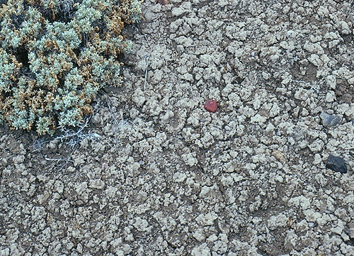
Smectite on Earth
Opportunity is on the hunt for the clay mineral smectites in Marathon Valley. This picture is a close up image of the crinkly, cracked surface typical of smectites found on Earth. Unfortunately, the remnants of the smectite clay minerals in Marathon Valley have not been this obvious, but the MER team knows that they're there and the hunt continues.University of Pittsburgh / Norris W. Jones
On Sol 4120 (August 26, 2015), Opportunity continued her investigation of Private Robert Frazer first conducting an MI finder frame to establish exact placement of the RAT brush and MI. The rover then deployed the RAT and brushed Frazer 6. She then took the pictures needed for an MI a mosaic of the brushed area and finally placed her APXS on the spot for integration the next sol.
The morning of Sol 4121 (August 27, 2015), the robot field geologist used her Pancam to take five more panels of the valley's north wall, as well as some more sky flats. Then she turned on the APXS for the chemical analysis Frazer 6. And on the next sol, 4122 (August 28, 2015), the rover rested and recharged, with her only science being a Pancam Tau to check the atmospheric opacity.
During the last weekend of August, Sols 4123-4124 (August 29-30, 2015), Opportunity
re-shot four panels of valley's north wall and followed the commands to send software engineers on Earth data from 16 sectors of bank 7 in her flash. While a "very poor predicted UHF downlink," as Nelson put it, resulted in the rover conducting no science on Sol 4124, she did successfully send data from 24 more sectors of flash bank 7 home.
With the data from bank 7, which had been erased during a reformat in March of this year, the MER flash team of software engineers, present and former, began the process of examining the code to search for any clues as to why the rover continued to suffer amnesia event and sudden reboots in the weeks following the reformat.
"We've been using low level commands to read out, address by address, the contents of bank 7 to see if there's anything in there that tells us anything," said Callas. "We're looking see if they get any errors or complaints from any address in bank 7, and what those errors are since they should all be erased."
At month's end, the flash software engineers were about one-third of the way through that read-out process, said Callas. "So far, we have found "no discrepancies, but we know there are some troubled sectors so we'll see what the [read-outs] tell us," he said.
Opportunity's power levels fluctuated between 426 and 394 watt-hours during August, not bad at all given the season. However, the rover's science schedule roving forward will be modulated by power, mostly because of having to operate in persistent RAM mode. "Trying to grind and drive and brush and do APXS, as well as a lot of imaging, it’s difficult to fit everything in," said Arvidson. "We’re really doing the best we can in optimizing the science return within the power constraints."
The MER team so far has been working successfully around the power limitations. In addition to implementing later X band uplinks to Odyssey and acquiring a "slight increase" in the number of MRO passes, the rover has been conducting overnight integrations with the APSX and copying the data stored in the instrument's non-volatile memory onto RAM the following sol for downlinking to Earth.
Meanwhile, as Opportunity looks around, the MER team is seeing more of what the scientists are calling "red zones" in Marathon Valley. At first blush, these red zones appear like the red zones that the rover inspected in different spots along the rim of Spirit of St. Louis Crater in June and July. In those Spirit of St. Louis red zone targets, the MER scientists found "an increase in sulfur and silicon and a decrease in iron," said Arvidson. While that is consistent with water alteration and indicates leaching, "we’re still trying to figure it out," he said.

Opportunity's recent roves
This image, which shows Opportunity's recent roves, was produced by Phil Stooke, an associate professor at the University of Western Ontario in Canada, author of The International Atlas of Mars Exploration Vol. 2, Spirit to Curiosity: 2004 to 2014, to be published by the Cambridge University Press later this year, and an active member of UnmannedSpaceFlight.com. The base image was taken by the HiRISE camera onboard MRO.NASA / JPL-Caltech / UA
The elusive smectite clay minerals may be 'hiding' in the red zones, or not. The detailed CRISM map that Arvidson created shows the smectite signature in "morphologically unusual and color-wise unique areas," he said. "The tilted planar bedrock that we're seeing is cracked into many polygons, with red zones in the fractured areas."
The CRISM signature, however, "maps continuously across the valley floor," Arvidson noted. "But we haven’t mapped the distribution of cracks or red zones to see if it’s actually across the floor or just coming from the red zones. We have a lot of work to do with testing the chemistry, the texture from the MIs, and a lot of Pancam color mapping."
The MER scientists are considering a couple of theories with regard to the locations of the smectite clay minerals. "One hypothesis is that the clay signature is all over, spread throughout the valley in all the bedrocks that we’re looking at, and maybe the signature is carried by the bedrock and it’s in the very surface. The other hypothesis is that it’s concentrated in these planar outcrops in between the cracks, the fractures in these altered zones," Arvidson summed up.
Data from Private Robert Frazer may uncover more clues. "Maybe the chemistry changes in a way that’ll tell us more," said Arvidson. "We’ve never been to an exposure like this, so it really is detective work."
To date, all the rocks Opportunity has checked out in and around Marathon Valley have been impact breccias and definitely not Matijevic Formation bedrock, Arvidson reiterated. "I think what’s happening is we’re way up topographically, relative to Cape York," he said. "And stratigraphically, I think we’re above the Matijevic Formation, which we think pre-existed Endeavor ejecta."
Squyres agreed. "It sounds like Matijevic Hill should be higher than Marathon Valley because one’s a hill and one’s a valley, but it’s all relative," he said. "We’re certainly higher up topographically, and I think we may be higher up stratigraphically as well."
In any case, Opportunity is roving around "a facie or a zone of ejecta, probably from Endeavor that’s different than anything we’ve seen before," said Arvidson. "It seems to be altered by water, so the detective work now is driving around and doing the best we can in RAM mode to understand the geologic context and the chemistry associated with these smectite signatures."
One thing is certain: the smectites are there somewhere in Marathon Valley and maybe everywhere, hiding in plain sight.
NASA / JPL-Caltech / Cornell / ASU
Pvt. Silas Goodrich
As August 2015 came to a close, Opportunity headed for a new target called Private Silas Goodrich, after a member of the Lewis & Clark Expedition. Although this raw image, which the rover took with the Pancam, is in black and white, Goodrich is "one of the red zone features that we think might be an alteration zone," said MER Principal Investigator Steve Squyres, of Cornell University.The MER scientists are still hoping to find something Noachian old, like they did on Matijevic Hill. "There is likely to be Matijevic Formation stuff below us somewhere, but how far down one would need to go to get it, we don’t know," said Squyres. "So we’re just going to keep looking. It could be 10 meters beneath us or 10 centimeters beneath our wheels. It’s hard to know. But remember, even at Matijevic Hill, we did a lot of wandering around until we came across Esperance. You never know when you’re going to hit the jackpot."
"If we’re lucky, we’ll find something like the Esperance fracture zone like we saw in the Matijevic Formation at Cape York – where the further we ground down with the RAT, the more it looked like it was highly leached, and that is consistent with a voluminous clay mineral," added Arvidson.
As Opportunity roves on in Marathon Valley, Herman continues updating the MER's energy projections and will keep updating as fall turns to winter at Endeavour. "Months ago, Squyres and Arvidson requested that I make very conservative assumptions in the energy model and back then, based on the low array energy predicts I saw as a result, I was a little nervous," she said.

Pvt. George Gibson
Opportunity took this image with her Pancam in August. It shows another possible water alteration zone, named Private George Gibson, after a member of the Lewis & Clark Expedition. Chances are, the robot field geologist will be checking out this target in September. The image was processed in false color by the Pancam team.NASA / JPL-Caltech / Cornell / ASU
For one thing, there is Mars' orbit. If one maps the Red Planet's orbit around the Sun for a whole Martian year, 360 degrees, the winter solstice – which occurs next on January 3, 2016 – is defined as solar longitude 90, or Ls 90 in the southern hemisphere of the planet, while the autumnal equinox in the southern hemisphere is Ls 0.
"It just so happens that Mars reaches aphelion, its farthest point in orbit from the Sun, around Ls 70, very close to our Ls 90 winter solstice," Herman explained. "Usually when we get to be around Ls 60, all the factors combine to reduce the total energy that Opportunity will produce with the solar panels. So we’ve got Mars farthest from the Sun in its orbit, plus shorter daylight hours, plus an unfavorable Sun angle."
Then of course there is the dust in the atmosphere and the dust on the rover's arrays. Actually, Opportunity's solar panels are cleaner than they’ve been the three prior Martian winters, said Herman. The dust on the rover arrays is currently blocking about 40% of the sunlight, better than last winter when it was blocking about 50%.
The energy needed to support the rover's heaters is also a significant factor for a rover's survival during a Martian winter. Again, there is "good news," said Herman. "As I have updated the power projections as the fall goes by, it turns out that Mars’ environment is more favorable than I had initially put into the model. The sky has been clear and the solar panels are relatively clean. So those initial assumptions have turned out to be worse than the reality. We’ve been fortunate."
After re-shooting a full 13-filter, color Pancam of Private Robert Frazer on Sol 4125 (August 31, 2015), Opportunity drove out of August, heading 13-meters (42.6 feet) farther into the valley to Private Silas Goodrich. "It’s one of these red zone features that we think might be an alteration zone," Squyres said.
The plan ahead is for Opportunity to examine more red zone rocks and materials for geological comparison to what she found along the rim of Spirit of St. Louis Crater and what she's found recently in Marathon Valley. But the grand red zone prize may be waiting at the valley's southern side, where, said Arvidson, "there is this extensive exposure that is highly fractured, with polygonal patterns and red zones."
NASA / JPL-Caltech / Cornell / ASU
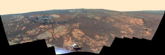
Matijevic Hill
Opportunity used her Pancam to capture this false-color panorama of the Matijevic Hill area on the Cape York segment of the western rim of Endeavour Crater in November 2012. The robot field geologist made history as the first Mars surface mission to groundtruth phyllosilicates in the form of smectite clay minerals, here in 2013. Although the rover has yet to identify the smectites the MER team knows are in Marathon Valley, the scientists know they're there because the Compact Reconnaissance Imaging Spectrometer for Mars (CRISM) onboard the Mars Reconnaissance Orbiter detected their signatures, just like it did on Matijevic Hill.Protect Our Shared Future
You help us defend humanity and prevent asteroid impacts. Donate now to become a Planetary Defender!
Donate