
 Explore Worlds
 Find Life
 Defend Earth


Mars Exploration Rovers Update: Opportunity Celebrates Milestones, Arrives at Solander Suburb
Sols 3355 - 3384

Written by
A.J.S. Rayl
Contributing Editor, The Planetary Society
August 5, 2013
Mars Exploration Rover
NASA / JPL-Caltech / Maas Digital
The Mars Exploration Rovers (MER) mission achieved more milestones in July as Opportunity celebrated the 10th anniversary of its launch on July 7, 2003, and then went on to pretty much complete the last leg of its 2-kilometer trek from Cape York to Solander Point along the western rim of Endeavour Crater. But just before the robot field geologist pulled onto the actual base of the ridge where it will spend its sixth Martian winter, Mars lured the team off the path with some of the weirdest Martian rocks the scientists have seen yet.
The veteran rover diverted off its course and into a kind of haunting suburb of Solander Point during the final days of the month. There, it found layered, coarse-grained, upturned dark boulders that look like mud to some and like nothing the MER scientists had seen in more than nine years of exploring Meridiani Planum. Opportunity wasted no time digging in.
"They are another interesting set of rocks that feature an abundance of rounded, sand-sized particles embedded in a matrix and cement," said Ray Arvidson, MER deputy principal investigator, of Washington University St. Louis (WUSTL). "They're different than anything we've seen before, except perhaps for some coarse-grained rocks in Endurance Crater."
With the base of Solander in clear view, any concerns about the rover not making it in time for its sixth Martian winter dissipated by mid-July. The plan had called for Opportunity to be at its winter destination on or around August 1st, but this date was based on predictions made earlier this year.
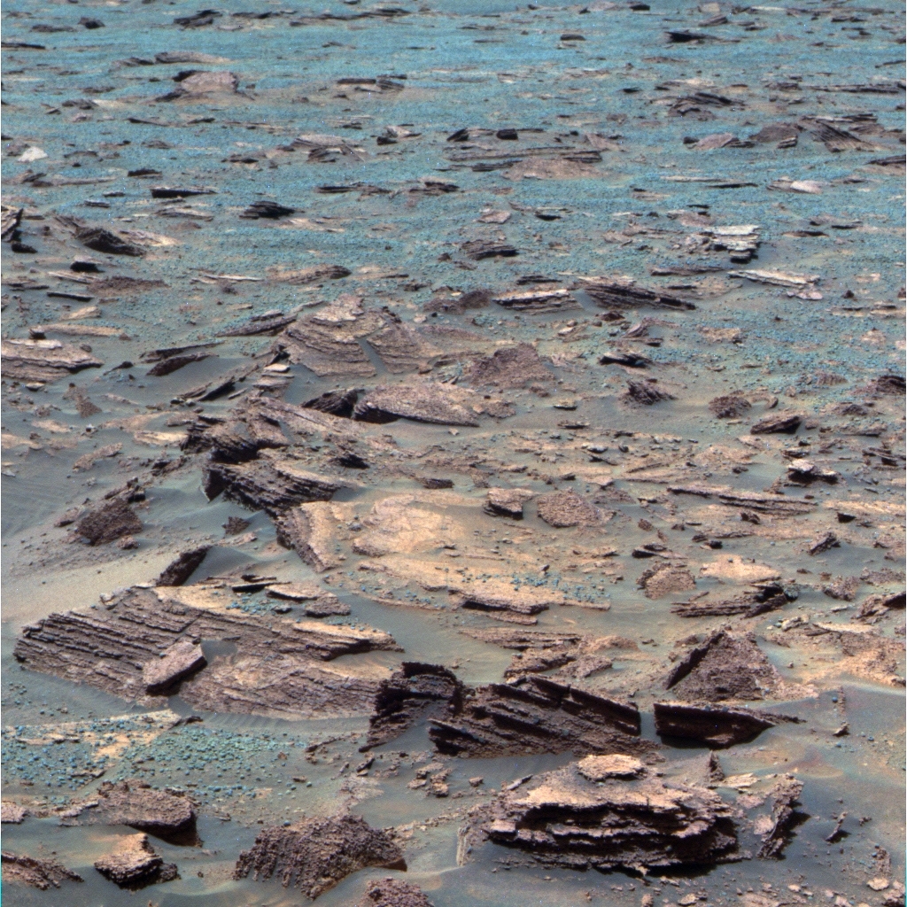
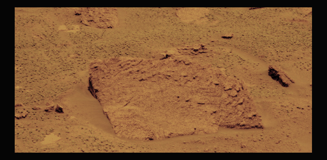
Dark, upturned Boulders in Ray's Box
In late July, Opportunity aimed her panoramic camera (Pancam) and snapped this image of the dark, upturned boulders in an area the team began calling Ray's Box. These layered, coarse-grained boulders feature an abundance of rounded particles. They are "different," as MER Deputy Principal Investigator Ray Arvidson, the namesake of the area, put it. Different than anything the MER scientists had seen in more than nine years of exploring Meridiani Planum, except "perhaps some coarse-grained rocks" the rover found years ago in Endurance Crater.NASA / JPL-Caltech / Cornell / ASU
Fair weather and level terrain changed that. "It was smooth sailing in July," said Ashley Stroupe, rover planner and driver at the Jet Propulsion Laboratory (JPL), where all the American Mars rovers were designed and built. And Opportunity managed to stay ahead of schedule and maintain better than expected energy levels.
"We effectively consider ourselves 'arrived,'" John Callas, MER project manager at JPL announced during an interview with the MER Update July 30th. So, even though Opportunity was not exactly at the base of Solander Point at month's end, the mission is no longer "under the gun" with the arrival at Solander Point, he said.
It gets better.
"Our energy looks like it's going to be a little better this winter than we previously had predicted," reported Bill Nelson, chief of MER rover engineering at JPL.
Actually, based on newly revised power predictions and the position of the Sun, the rover doesn't have to be up on Solander Point and on a north-facing slope, where it can angle itself and its solar arrays to the winter Sun, until the beginning of December, Callas said. That means Opportunity has about four months to explore the surroundings at the bottom of this part of the eroded rim of Endeavour Crater - and there's a lot to see and do. The scientists hope to check out two different contacts or boundaries between geologic layers visible at the base of the ridge, as well as anything else that looks interesting before settling in for winter.
As feared and dreaded as Martian winters are, the prospects for Opportunity are about as bright as they could be as the robot field geologist gears up to face her sixth harsh season. The slopes at Solander look so opportunistic that the rover may not have to park for the whole season. "We may have limited mobility throughout the winter," said Arvidson.
When Opportunity does begin the climb up Solander Point, it will kind of be like "the wide receiver standing at the one yard line with no one around him, and he kind of just steps over the goal line," said Callas. The game-winning touchdown will likely come with the discoveries to follow in the most extensive stack of rocks and layers that the MER team has encountered, much of which dates to the Noachian Period some 3 to 4 billion years ago when Mars was warmer and wetter.
During the first half of July, Opportunity sprinted across Botany Bay, the parking-lot-like terrain between Nobbys Head and Solander Point, logging more than 215 meters in seven drives. With all things looking good and the journey to Solander Point nicely ahead of schedule, the team decided it had the time and Opportunity had the energy to divert from its rapid transit route into an area that appears darker in images taken from orbit by the High Resolution Imaging Science Experiment (HiRISE) camera onboard the Mars Reconnaissance Orbiter (MRO).

NASA / JPL-Caltech / University of Arizona
Opportunity 10 years after launch
This image taken by the High Resolution Imaging Science Experiment (HiRISE) camera onboard NASA's Mars Reconnaissance Orbiter (MRO) captures Opportunity as she was roving south (at the end of the white arrow) to new science targets and the place where she will spend her sixth Martian winter, Solander Point, another portion of the dissected Endeavour rim. The relatively level ground between Cape York and Solander Point is called Botany Bay. The image was taken 10 years after Opportunity was launched from Florida on July 7, 2003, EDT and PDT (July 8, Universal Time).Data from the Compact Reconnaissance Imaging Spectrometer for Mars (CRISM), a visible-infrared spectrometer searching for mineralogic signs of water, also onboard MRO, indicated that something in this darker area was harboring evidence of past water.
Previously, in April and May of this year, Opportunity groundtruthed CRISM's detection of clay minerals and a potentially habitable environment at Cape York, the part of the dissected rim of Endeavour Crater that the rover first explored after arriving at the big hole in the ground in August 2011. "This was very much like Matijevic Hill, where we said: 'Let's turn right and go uphill, because that's where we're seeing the clay minerals,'" said Arvidson. "This time it was: 'Yo guys, let's turn left and head east into this dark area we see in HiRISE, because CRISM is showing us something different.'"
Since this scenario was reminiscent of the decision the MER team made to check out Matijevic Hill - after Arvidson, who is also a member of the CRISM team, mapped the "sweet spot" of the clay minerals detected by infrared spectrometer to Matijevic Hill - team members began referring to the area Ray's Box while Arvidson was on vacation.
At Ray's Box, however, CRISM was not detecting a clay signature. "We don't know what it is, but it's a feature associated with water bound up in minerals and it corresponds to yet another unusual set of rocks that are very coarse-grained, sulfate-rich sandstones," said Arvidson.
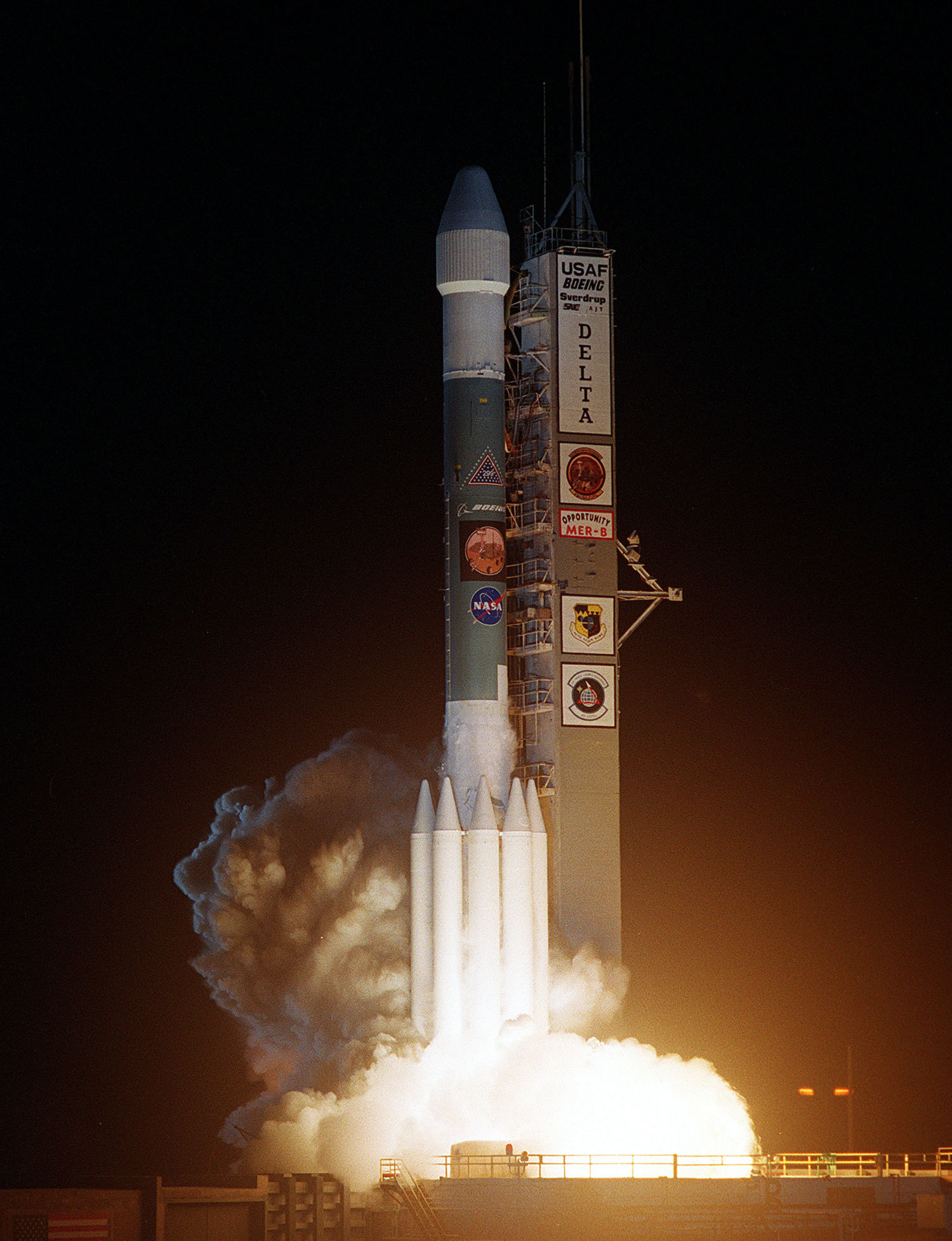
Opportunity leaves Earth
Opportunity left the Earth aboard a Delta II launch vehicle at 11:18:15 pm Eastern Daylight Time from Cape Canaveral Air Force Station, Florida on July 7, 2003, Pacific Daylight Time, and Eastern Daylight Time (July 8, 2003 Universal Time). The bright glare of its rockets briefly illuminated Florida Space Coast beaches. After it had been boosted out of Earth orbit 83 minutes later, the spacecraft separated successfully from the Delta's third stage, and headed on toward Mars.NASA
Along the way to Ray's Box, the robot field geologist took advantage of the luxury of time and stopped to smell a couple of scientific roses. After conducting a drive-by shooting of a small crater dubbed Charlie Brown [after the command service module of Apollo 10], the rover "tasted" the soil at a patch of Martian dirt nicknamed Queen Adelaide - "it's basalt," said Arvidson. Later, the rover paused to soak up sunlight and take images of the Martian moons' transits of the Sun with the Panoramic Camera (Pancam).
Then, during the last week of the July, Opportunity moved in on the boulders in the dark suburb of Solander. The robot field geologist took some color pictures with its panoramic camera (Pancam) of one large dark boulder dubbed Rusty Crevice and then roved up to another, called Black Shoulder, for a close-up study. A sandy conglomerate that is "an amalgamation of rounded particles that may be a millimeter or less across," as Arvidson described it, Black Shoulder is something that's very unusual. And it's where the rover spent several of the last sols or Martian days of the month digging in to get a better look.
Since the beginning of the mission, the MER team has picked themes for naming rocks and targets that Spirit (which ceased communications in March 2010) and Opportunity would find on their expeditions. "On Opportunity, it has been broadly themed to exploration," noted Larry Crumpler, associate research professor, University of New Mexico, research curator volcanology and space sciences at the New Mexico Museum of Natural History and Science, and MER science team member and long-term science planning lead. "In the case of the region between Cape York and Solander Point, we are using a variety of Southern Pacific/Captain Cook/Australian names. So Black Shoulder and Rusty Crevice are names of reptiles and lizards from that geographic region."
There are a lot of big dark boulders in this Solander suburb that are layered, coarse-grained, up-turned, and have the newly found rounded particles, said Arvidson. "The particles are unusual, but could be parts of basalt of Mars that have been rounded," he said. "They could be concretions formed by water, and they are sulfur-rich, much like the rest of the Burns Formation strata. Or perhaps they are just clusters of blueberries stuck together in a matrix of cement and fine-grained materials."
It would seem that the dark boulders, and maybe the matrix and cement, are harboring the evidence of past water that CRISM detected. "But it's very early," Arvidson cautioned.
As the Sun began to set on July, Opportunity took an 8-meter hop to the complete the stereo imaging of the inboard side of Solander Point. "The current stereo imaging campaign will help us not only plan an interesting science traverse up into Solander, but will also help us find the best sunward tilts needed to keep the rover alive and busy during the oncoming Martian winter," said Planetary Society President Jim Bell, panoramic camera (Pancam) lead scientist, of Arizona State University.
In coming sols, Opportunity will drive onto the apron surrounding the base of Solander Point, known in geology jargon as the Bench, and chalk up its 38th kilometer. That total drive distance is now still some 2 to 4 kilometers from besting the Lunokhod 2 record, depending on who you talk with.
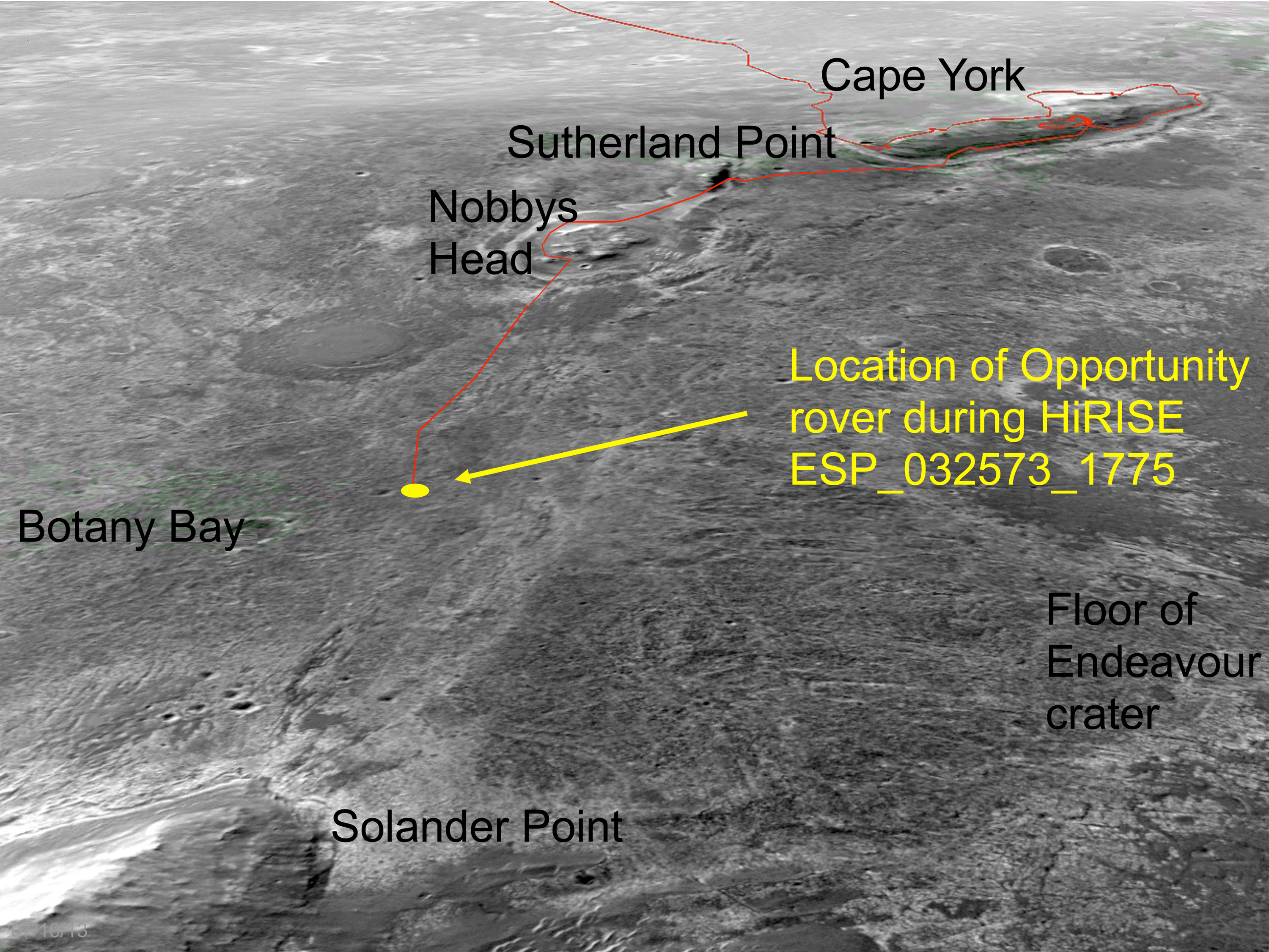
Overhead of Opportunity's journey
This oblique, northward-looking view is based on stereo orbital imaging and shows the location of Opportunity on its journey from Cape York to Solander Point when HiRISE took the new color orbital image of the rover. Endeavour Crater is about 22 kilometers (13.67 miles) in diameter. The distance from Cape York to Solander Point is about 2 kilometers (1.2 miles). The red line indicates the rover road traveled.NASA / JPL-Caltech / University of Arizona
As reported in last month's MER Update, Irina Karachevtseva and a team of Russians refined Lunokohod 2's total distance to an estimated 42.1 kilometers after reviewing images from the Lunar Reconnaissance Orbiter Camera (LROC). Meanwhile, a team headed by Brad Jolliff, of WUSTL, has come up with an estimate that is closer to 40 kilometers.
"We are working with Russian colleagues to compare cartographic methods and results, and to see if we can converge on what we all agree to be the best measure of the traverse distance for comparison to Opportunity's traverse distance," said Jolliff, who is also a member of the LROC team.
For now, the MER team is focused on checking out the base of Solander Point. With time on her side and empowered with enough energy to keep moving and working, Opportunity will spend the next four months or so checking out the Bench, as well as the contacts or boundary areas on both the eastern and western sides of the bench surrounding the Point where the geologic terrain changes dramatically.
"We have enough time I think to explore the Bench pretty thoroughly and there's a strong interest in going to the northeastern corner of Solander Point on the Bench, and then kind of work our way counter-clockwise around the northerly tip of the ridge," said Arvidson. "And then we'll get up onto the Noachian outcrops where hopefully we can see more of this Whitewater Lake-material outcropping."
The Whitewater Lake unit is where Opportunity groundtruthed evidence for the clay minerals and a lot of flowing, near neutral water at Matijevic Hill, water much like we know on Earth.
After celebrating Opportunity's 10th anniversary of leaving Earth July 7th, the rover, more than nine years and six months into her scheduled 90-sol mission, is "still hanging in pretty nicely," said Nelson.
Perspective on how far this rover has traveled, how many discoveries she's made and what a robot hero she has become in the 10 years since launching turned up in an image taken by the University of Arizona's HiRISE camera on July 8th. There, but a tiny dot in a falsely colored blue image, is the rover that loves to rove, some 38 kilometers from her landing spot in Eagle Crater, in a place the team never in their wildest dreams imaged their explorer would go.
NASA / JPL-Caltech / UA / S. Atkinson
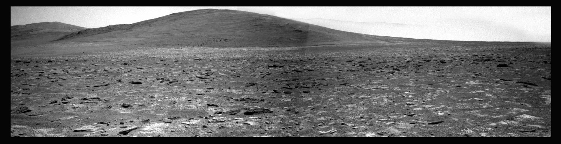
Solander ahead
Opportunity took the pictures that went into this image of Solander Point in late July as she was closing in on the ridge where she will spend her sixth Martian winter. Stuart Atkinson, MER poet, author, member of UnmannedSpaceFlight.com, and frequent contributor to the MER Update, mosaicked it together into this presentation. Atkinson has been following Opportunity's journey to the big crater in a blog called The Road to Endeavour."We have been seeing this perspective for some time," said Nelson. "But it is really exciting to be able to see something that small from that far away."
"When we launched Opportunity, we never thought we'd get to see her again, so it's great to actually see her," agreed Stroupe. "The thrill is still there, because it's always a different picture."
Opportunity from Meridiani Planum
After inspecting a rock called Tawny, Opportunity drove out of June with a sprint of more than 30 meters (about 98 feet) on Sol 3353 [which was June 30, using the Pacific Daylight Time date at noon of the sol; no sol's noon fell on June 29].
When July dawned at Meridiani Planum, the rover was taking a break to recharge and conduct routine measurements of the dust in the atmosphere. But on Sol 3355 (July 2, 2013), Opportunity was back on the road and she completed a long drive of more than 118 meters (about 262 feet).
Opportunity route map
This route map, produced by Eduardo Tesheiner, of Unmanned Space Flight.com (UMSF) shows Opportunity's travels around Cape York and through Sol 3374 (July 21, 2013) and its approximate current position. Tesheiner creates his route maps, which are regularly featured in the MER Update, from images taken by cameras onboard the Mars Reconnaissance Orbiter.NASA / JPL / UA / E. Tesheiner
In preparation for the long American Independence Day holiday "weekend" around the Fourth of July, the MER team prepared two sets of three-sol plans to keep Opportunity busy while the flight team took a break.
During the first plan - Sols 3356 to 3358 (July 3 to July 5, 2013) - Opportunity completed another 25-meter sprint (82-foot), a drive that included a special automatic stop so that the solar-powered rover could take advantage of the tilt at the stop point, to soak up the Sun and achieve maximum power generation for later activities. From that spot, the robot field geologist took an atmospheric argon measurement with her Alpha Particle X-ray Spectrometer (APXS) on the second sol of that plan, and then conducted routine remote-sensing measurements on the third sol.
Using the extra energy from its favorable tilt in the second three-sol plan, Opportunity gazed at the Martian moons in the early morning hours of Sol 3360 (July 7, 2013) local Mars time, taking pictures of both Phobos and Deimos with her Panoramic Camera (Pancam). And then, because the MER flight team received the results from Opportunity's Sol 3356 drive in time for commanding this second three-sol plan, the rover put another 42 meters (138 feet) on her rocker bogie to celebrate her 10th anniversary of leaving Earth. The robot field geologist spent the final sol of the plan recharging her batteries and conducting some light remote-sensing observations.
Although Opportunity had had some issues with a couple of drives in June, she had no issues in July and seemed to sail across Botany Bay toward Solander Point. Back in June, the rover was stopped twice in her tracks when the potentiometer on her instrument deployment device (IDD) or robotic arm indicated her "elbow" had moved. Such movement is not intended or desired during a drive and when it occurs, it stops the drive. But after conducting a set of diagnostics on the Joint 3 or elbow sensor, the MER flight team engineers concluded that the readings from the potentiometer readings were anomalous, and that the arm actually did not move. It would appear that the potentiometer has simply worn out.
So in July the rover engineers masked that potentiometer in Opportunity's flight software so that anomalous readings would no longer stop a drive. "We have masked off that potentiometer for all subsequent drives and from a presentation [July 25th] it looks like, from the data collected, that this has saved several drives since then," said Nelson.
The flip side, however, is that if the arm does move, the MER flight ops team won't know from that sensor. "It's highly unlikely, but suppose something were to hit the IDD as we're driving. It would stress that joint, be seen as a change in that potentiometer, and normally it would stop the drive," said Nelson. "Now if we hit something, the potentiometer is masked off, and so we'd just keep driving," Nelson confirmed.
The risk of Opportunity's arm, which is slightly above the deck pan, hitting something is actually "pretty tiny," he said. "Among other things, we're driving backwards. That means the whole body of the rover would pass over this thing - whatever it might be that could cause the IDD to move - before it would hit the IDD. And the face, looking toward the body of the rover, which would be the first part of the IDD to encounter said object would be the M"ossbauer spectrometer, which has its contact plate as its leading part. So, if we did actually get into this situation and were about to bang into something, it would first hit the M"ossbauer contact plate, trip the contact switches and that would stop the drive," he explained. "So we're pretty confident that masking off this potentiometer doesn't really add any risk to the mission."
"We are being careful," added Stroupe. "We're either driving in the imagery where we can see there is nothing there or we're turning on hazard avoidance, which is scared of things that are smaller than what would hit the IDD. So we're using that to protect ourselves," she explained. "It's extremely difficult to conceive of a case where [Opportunity] could actually drive over something and hit the arm."
Once the fireworks and holiday picnics of July 4th were history, Opportunity continued to push closer to Solander Point during the second week of the month. The robot field geologist was roving so well the MER flight ops team commanded her to drive back-to-back on Sols Sol 3362 and 3363 (July 9-10, 2013), for more than 88.7 meters (291 feet) and about 59 meters (193 feet) respectively.
As Solander came closer into view, the rover that loves to rove made the final leg of the journey from Cape York to Solander Point look like a walk in the park - despite having to drive backwards holding her arthritic arm in a fishing pole position, despite a stiff, toed-in front wheel, and despite the need to shut down every night and cast her engineering marvels to the fates of Mars each because of a stuck-on, power-draining heater.
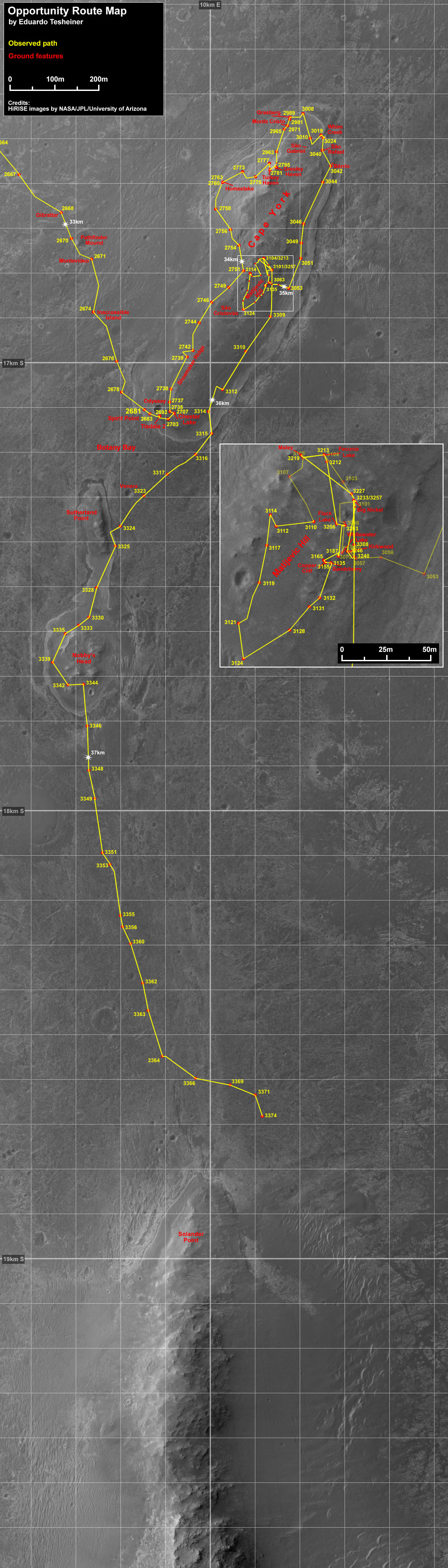
View of Botany Bay
This view shows Botany Bay and the mosaic pavement of fractured, light-toned bedrock that Opportunity crossed in June and July on the way toward Solander Point, which is visible on the horizon. The rover used her rear hazard identification camera to record this southward view at the end of a 118-meter (387-foot) drive on her Sol 3355 (July 2, 2013). For scale, the distance between the two rear wheels visible in the foreground is about 1 meter (3.3 feet). The underside of Opportunity's deck appears at the top of the image. A mixture of darker-toned basaltic soil and small, hematite spherules, nicknamed blueberries, fill cracks between the bedrock pieces and thinly cover some of the bedrock.NASA / JPL-Caltech
By mid-July, Opportunity was less than 300 meters (984 feet) from the base of Solander Point and producing plenty enough energy to meet the August 1st arrival target date. The skies overhead had actually cleared a bit, as opposed to getting any worse and the rover had accumulated a little less dust than earlier analysis predicted.
So, the MER team decided to use a few of the "margin" sols accumulated to investigate the dark, hummocky area characterized by large boulders with rounded particles, known as Ray's Box. With a multi-sol drive in a three-sol plan uplinked for Sols 3366-3368 (July 13-July 15, 2013), the team directed Opportunity to the east and into Ray's Box.
The rover veered to the southeast on Sol 3366 (July 13, 2013), driving 80 meters (262 feet) toward the area just to the northeast of Solander Point. That drive was the start of "the first attempt at multi-sol driving," said Nelson. "We recently decided it was safe to do and have approved doing it. The idea is we do a drive, set a flag that says the drive was successful or not. The next sol we look at that flag and if it was successful we would continue and drive on the second sol."
But at the end of that first drive, Opportunity wound up in a shallow depression, wherein she exceeded her pitch-limit. As a result, "the rover never got off the dime" for the second scheduled drive in the plan on Sol 3367 (July 14, 2013), said Nelson. "The first Sol 3366 was an 80-meter blind drive and that completed successfully. Then the second drive on Sol 3367 failed, because we tripped a tilt limit during the first arc, basically while doing a turn in place," he explained. The tilt limit, essentially a safety check specifically designed for multi-sol drives, worked just like it was supposed to and prevented the rover from trying to take off.
The next drive sol, however, Opportunity did get off the dime and, as the third week of July set in, she headed east for 77 meters (252.62 feet) and toward Ray's Box on Sol 3369 (July 16, 2013), Nelson reported.
"From CRISM, we see pretty strong evidence of water hydration at 1.9 micrometers and it's an unusual spot," said Arvidson, "It's a different looking set of rocks that I think are stratigraphically on top of the Burns Formation. There's just been so much wind erosion that all that's left is a set of upturned layered rocks that are coarse-grained, but certainly different, and likely carrying the 1.9 micrometer water feature we see in the CRISM data."
Opportunity had an easy sol on her 3,370th day on Mars, collecting just three taus. "The reason we do taus at different times is to try and characterize the dust on the lenses, which can masquerade as the atmospheric dust we're trying to measure," Nelson explained. "So we do multiple taus and sometimes use different cameras to try and zero out that signature."
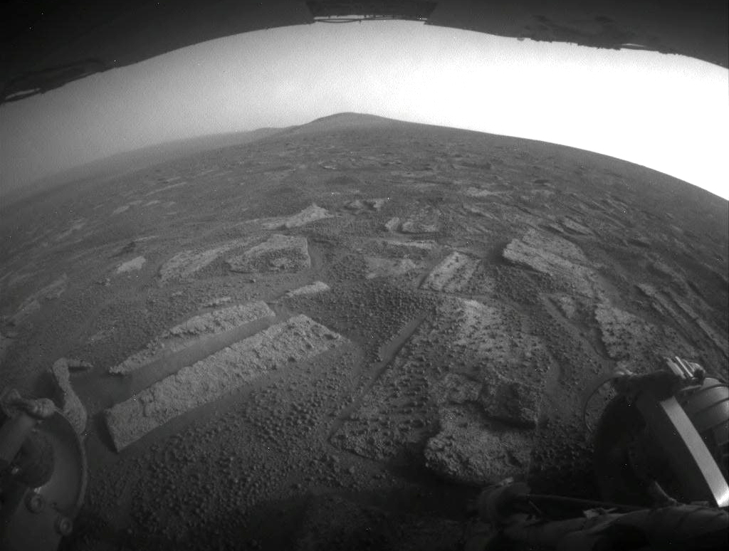
Queen Adelaide
Toward the end of July 2013, Opportunity took some close-up pictures of Queen Adelaide, a soil target, with her Microscopic Imager (MI), and then followed it with the usual APXS analysis. "We think the soil is similar everywhere, but it's worth checking occasionally," said Ray Arvidson MER deputy principal investigator.NASA / JPL-Caltech
The next sol, 3371 (July 18, 2013), the first of a 2-sol plan, Opportunity closed in on the dark, hummocky area with a 60.85-meter (199.64-foot) drive, stopping midway to conduct a drive-by shooting of a small crater called Charlie Brown. But Sol 3372 was "surprisingly disappointing," said Nelson. "We did a single tau. We had driven on the first sol and we're in restricted mode, so we didn't really have any data down from the Sol 3371 (July 18, 2013) drive to plan anything on 3372 (July 19, 2013), so we postponed driving until that data came down," he explained.
Opportunity roved into the last week of July, conducting a touch 'n go on Sols 3373 and 3374 (July 20 and 21, 2013), She took close-up pictures with her Microscopic Imager (MI) of Queen Adelaide, a soil target, and followed it with the usual APXS analysis on the first sol. "We think the soil is similar everywhere, but it's worth checking occasionally, so it was a convenient time to do an MI and APXS touch 'n go during that weekend plan," said Arvidson. "Plus, if we think the soil is the same everywhere and it is, this is a good way to calibrate any drifts in the APXS measurements," he added.
Opportunity completed the touch 'n go with a drive of 51.01 meters (167.35 feet) the following sol. "The rover ended up at the top of a very small ridge about 10 meters from the target the team had chosen for Opportunity to investigate," said Nelson.
The robot field geologist spent two days at this lily-pad location, soaking up as much Sunpower as her position allowed on those two sols. She kept busy by taking some routine measurements and conducting some remote sensing with her Pancam, including pictures of dark boulders dubbed Rusty Crevice and Black Shoulder, both of which are "upturned, layered, and seem to be very coarse-grained," as Arvidson described them.
"The key thing we did on Sol 3375 (July 22, 2013), was to have the rover prepoint her Pancam," said Nelson. "That set us up on Sol 3376 (July 23, 2013) for the Deimos transit observation."
Normally, Opportunity stows the Pancam after use by pointing the camera a little below the horizon so it's protected from dust. "When we prepoint, we click the camera to where we want it to be plated and will not do the stow," Nelson said. "We leave it exposed to dust for hopefully a short period before the observation."
Usually prepointing is done because observations that are either very late or very early require the rover to heat the bearings and actuators of the Pancam mast assembly. "We would prefer not to spend all the time and energy that it takes to do that, so instead we'll point it at a time when it's warm and just leave it, and then we don't have to any heating, nor do we have to wake up early to do that heating," said Nelson. "However in this case the driver was not the temperature, it was the timing. Because we were really close to when we wanted to start the drive and so we prepointed in the plan just to save time."
"It worked," summed up Arvidson.
Heading into Ray's Box
Just before reaching the base of Solander Point, Opportunity and the MER team took a slight detour off the planned route to investigate an area that appeared darker in images taken by the University of Arizona's HiRISE camera onboard MRO. The area is marked with large dark boulders that sport an abundance of rounded particles that had the MER scientists scratching their heads in July.NASA / JPL-Caltech
On Sol 3376 (July 23, 2013), Opportunity successfully snapped pictures of Martian moon Deimos' transit of the Sun with her Pancam. Then, she bumped 3.74 meters (12.27 feet). "That bump brought us up to Black Shoulder," said Nelson. "We did post-drive imaging and on Sol 3377 (July 24th, 2013) we did a Pancam Deimos observation again, of another transit."
Combined with the MER flight ops team's reanalysis of the rover's status and the Martian weather, Black Shoulder effectively signaled arrival at Solander. "We did a power assessment and we assessed that we are a little bit ahead of where we were last year [winter] for power production," said Callas, "and only three drives from Solander Point."
"It is exciting to see how quickly we've traversing across Botany Bay towards Solander Point - the rover drivers really knows how to move this vehicle!" said Bell.
So, even though Opportunity wasn't actually on the Bench at the base of the ridge that will be her winter haven, the journey from Cape York to Solander Point was a success and she had, for all intents and purposes, arrived. The arrival at Solander is, said Callas, "kind of like saying you've arrived in New York. Are you downtown, midtown, or the Jersey Shores?"
"In terms of concerns about the winter, we were close to where we need to be [in mid-July] with enough margin," said Stroupe. "Remember, when we had to plan this journey, we weren't sure if we would have a dust storm or how fast the dust was accumulating on the rover. Now we've been through most of the summer and have a much more accurate model of what to expect, which means we can take out some of the margin we built in early on," she said.
"Also, the rover is a little bit cleaner and the sky is a little bit cleaner than it was and that means we don't need quite as high a tilt to survive," Stroupe continued. "We couldn't count on the fact that Mars was going to be kind. But it was. So that's given us extra margin and now we don't need those northerly tilts until December. We actually have this luxury of time."
During the last weekend of July, Opportunity began an in-situ investigation of Black Shoulder with her Microscopic Imager (MI) and APXS. And, on the following Monday, the rover's Sol 3382 (July 29, 2013), the rover pulled out her Rock Abrasion Tool (RAT) and ground into Black Shoulder to get a better look at the surface. As usual, the robot field geologist followed the grind with an APXS overnight integration the following sol.
"Now that we have finished the measurements, it looks rather like a sulfate-rich sandstone similar to the coarse-grained rocks we saw in Endurance Crater," Arvidson reported at month's end. It's worth noting that the RAT, remarkably, still has quite a bit of bite, according to the pictures Opportunity took of the instrument in late June, to see how the instrument was holding up. "The bit images did come down [in the downlink] and no appreciable bit loss was observed," confirmed Gale Paulsen, senior systems engineer, Honeybee Robotics and Spacecraft Mechanism Corporation, who oversees RAT operations on Opportunity.
As July turned to August, Opportunity roved on, driving a brisk 8 meters (26.25 feet) on July 31st, to finish taking a stereo, color image of the inboard side of Solander Point with the Pancam. The Pancam team will later combine these images with images taken earlier, and create a digital elevation map, known as a long baseline stereo image of the inboard side.
"By going east we get a better view of the topography of the inboard rim of Solander," said Callas. "This may be the only time we see it, because [after winter] we may be approaching Cape Tribulation from the outboard side of the crater. So this may be the last shot."
Throughout July, the skies over Endeavour Crater were typically hazy, normal for this late Martian summertime, but most importantly they didn't get worse. The rover registered taus or atmospheric opacity that fluctuated from 0.786 at the beginning of July, dipping to 0.705 mid-month, and then rising slightly to 0.757 at month's end. Opportunity's solar array dust factor got a little worse, but not by too much, going from 0.606 as July dawned to 0.584 mid-month 0.566 as August was taking charge.
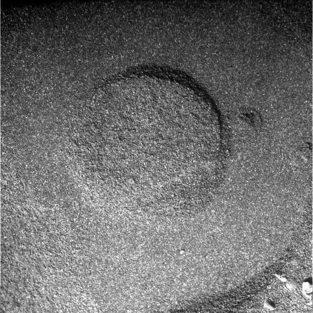
Rusty Crevice
Opportunity took this picture of one of the weird, upturned boulders it found in July. It was colorized and labeled by Stuart Atkinson, of UMSF.com, who has been following Opportunity's path to Endeavour not only here but in his blog called The Road to Endeavour.NASA / JPL-Caltech / UA / S. Atkinson
Physically, Opportunity remained in good health throughout July. Her energy levels generally decreased slightly, from around 450 watt-hours at the beginning of the month to around 430 watt-hours at the end. That's less than half full capability the rover had on landing, but still plenty enough to drive and take care of science business. "The vehicle is well behaved," confirmed Callas. "We haven't had any anomalies. Nothing recently, so for an old girl she's doing well."
After driving 737.91 meters in July, Opportunity heads into August with 37.98 kilometers (23.60 miles) on her odometer and Solander Point right there, clearly in view. Despite the coming winter, the veteran robot field geologist appears to have many more bright sols ahead and, it could be argued, she is already inspiring "old girls" of all species everywhere.
Opportunity will continue trundling along on fairly level terrain for all least a few drives. "We have to be on Solander to get greater than 0," Stroupe said. "That was part of why we had to make this long trek. It's pretty much negative or 0 until you hit that mountain, and then it starts tilting north. There are a few lily pads between the rover and Solander, but they're not everywhere and they're not much above 0. It's not really until we get to the Bench around the base of Solander that we will begin experience real northerly tilts."
From another engineering achievement to another potential science headline in the Martian weirdness of Black Shoulder, July 2013 added to the MER mission's memorable sixth summer of exploration. The punch line for July, said Arvidson, is: 'Hey team, let's turn left and head east because CRISM is seeing a 1.9 micrometer feature.' And, so far, it's been a good payoff. We found coarse-grained sulfate-rich rocks, and the cement and matrix may be hydrated," he summed up. "We are still working on reducing and interpreting the data."
Prior to ascending Solander Point and positioning herself on a choice north-facing slope as the Martian winter blows in, Opportunity will be checking out the Bench, and whether or not the this Bench represents the surface exposure of very old strata that lap onto Endeavour Crater's rim.
"The team is interested in whether or not this Bench is different than the Bench at Cape York," said Arvidson. "I think there's a growing consensus in the team that the Bench represents some of the older sedimentary rocks that have been onlapped or buried in large part by the younger Burns Formation material," he said.
"You can imagine going back in time to the making of Endeavour Crater - that's Noachian - a period of time when rivers were flowing occasionally if not always, and a lot of erosion was happening, so Endeavour's crater rim was eroded down," Arvidson said, beginning a nutshell summary of what likely may have taken place.
"Botany Bay is a place where most of the rim is gone and Solander Point is where some of it is still sticking above," he continued. "Then the environment changed, from extensive erosion in the area to accumulating sedimentary rocks and the hydrological cycle started to calm down a bit. That's when materials accumulated right up against the remnants of the rim - and that's the Bench. Later, there were groundwater-rising events and the formation of the sulfate sandstones that make up the Burns Formation. And then the whole system shut down and moved to wind erosion."
NASA / JPL-Caltech
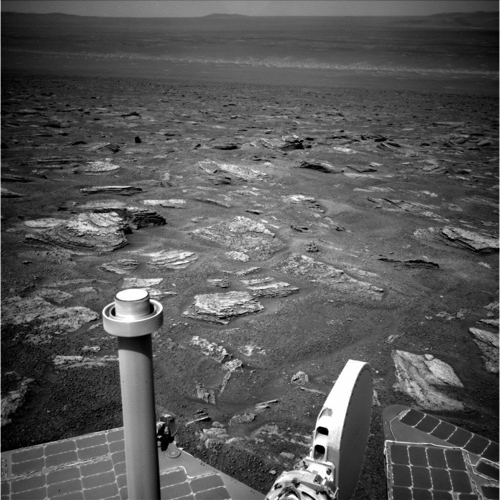
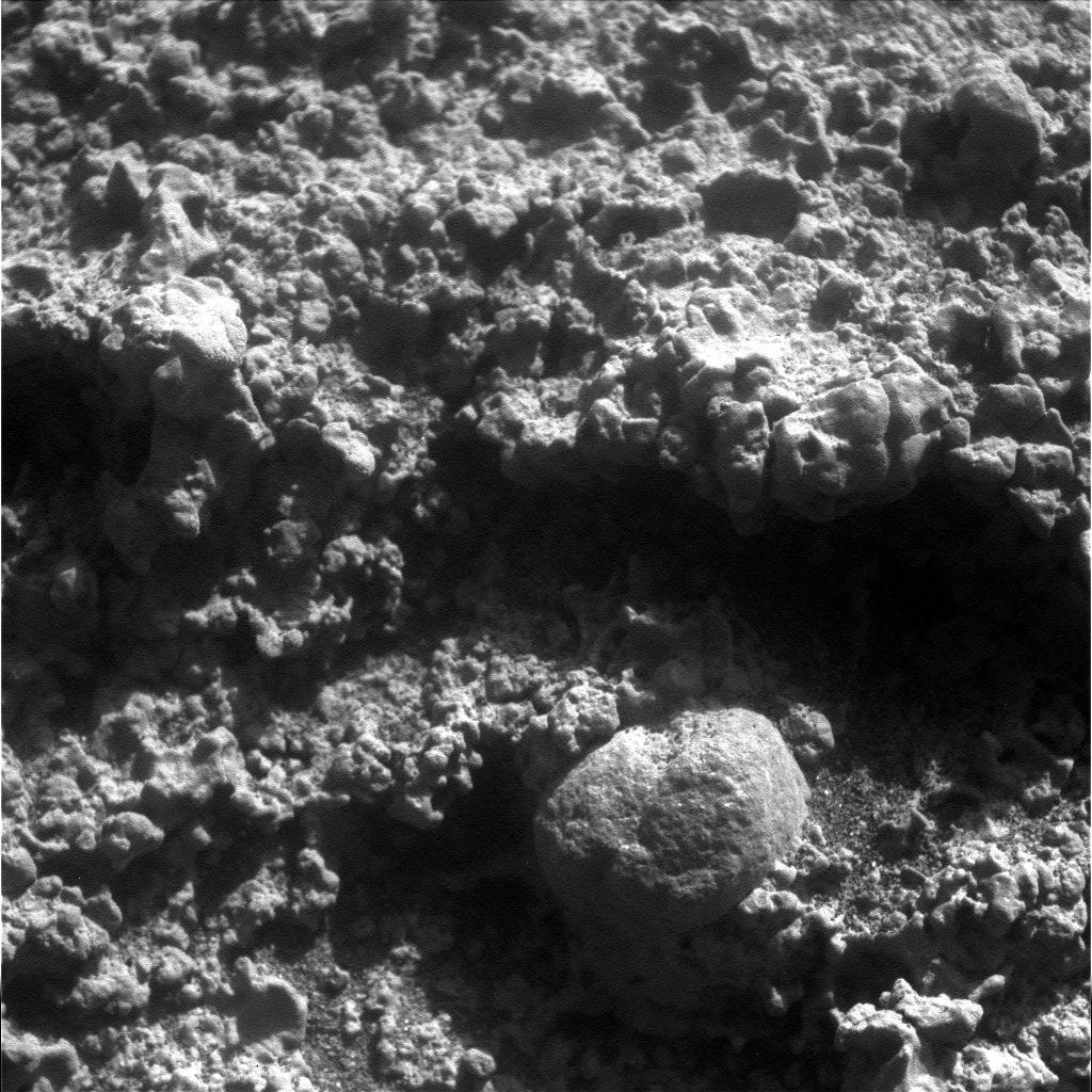
Black Shoulder up close
This close-up mosaic image shows Black Shoulder, one of the dark, upturned boulders in the Solander suburb, called Ray's Box by team members. Opportunity used her microscopic imager (MI) in late July 2013 to take a series of pictures that went into this mosaic and after RATing into the surface and analyzing it with its APXS, found that the rock was rather like "a sulfate-rich sandstone similar to the coarse-grained rocks we saw in Endurance Crater," according to Ray Arvidson.As August sets in, the plan calls for Opportunity to roll on toward the base of Solander Point. The rover will likely break the 38-kilometer mark with its next drive, to chalk up yet another milestone for the MER mission.
"There is a lot to explore around Solander Point and we will use time now to explore the base of this hill," said Callas.
Opportunity seems as ready as ever. "Everything's been great, said Stroupe. "Everything is going very well."
Protect Our Shared Future
You help us defend humanity and prevent asteroid impacts. Donate now to become a Planetary Defender!
Donate