
 Explore Worlds
 Find Life
 Defend Earth


State of NASA Earth Observation

Written by
Anna Scott
Ph.D. Student, Earth and Planetary Science Department, Johns Hopkins University
May 12, 2016
Fifty-eight years into the satellite age, remote observation of our planet can track weather patterns, atmospheric composition, and ecology, helping to measure things as disparate as ocean biological cycles near Antarctica (thanks Suomi!) and reservoir depletion in India (thanks Grace!). As an introduction, consider reading this article by Jason Davis. Since he posted it in 2012, a number of NASA Earth-observing satellites have gone up and down—2015 saw a satellite go up nearly every other month—so I’ll get you up to speed. One caveat: I’ll only discuss NASA missions in this article, which ignores the great work done by ESA (the European Space Agency), JAXA (the Japanese space agency), and others. I’m only considering science-oriented Earth observation, perhaps to our detriment as our military has so many satellites that they give them away.

Global Precipitation Measurement (GPM)
Having access to a rainfall dataset with continuous, global coverage is so important that I get emotional explaining it. It not only saves days of data-wrangling headaches, it saves years of legwork pleading for access and then hammering out data-sharing agreements between the Meteorology Offices of the world. Many cash-strapped countries won’t share their weather data unless scientists share their sweet, sweet research money (which always requires even more bureaucracy and paperwork), and there are still plenty of places that use analog instruments, which makes sharing harder even if agencies are willing. Also, as weather stations tend to congregate where people are, satellite-based rainfall data benefits anybody interested in weather, agriculture, or ecology but lacking a local weather station. For the past 17 years, measuring rainfall from space was done with a satellite called TRMM (Tropical Rainfall Monitoring Mission), which measured rainfall rates in the tropics. Now, TRMM has been turned off and is slowly dropping back to Earth. This stuff is so important to Earth Scientists that I saw honest to goodness TRMM eulogies on social media. Replacing TRMM is the Global Precipitation Measurement (GPM) mission, launched in February 2014, and with improved global coverage—TRMM only covered the tropics.
Soil Moisture Active Passive (SMAP)
SMAP launched in January 2015, but over the summer the radar became inoperable—the amplifier failed because of power supply issues. It’s too bad, because the passive radiometer cannot penetrate below the ground. Subsurface data is an important part of calculating soil moisture because the zone right below the soil surface (so-called “root zone”) is critical to plant growth, so this is a disappointing turn of events. That being said, the radiometer still works and still provides surface-level data, just at a lower resolution than planned (40 kilometers per pixel versus 9 kilometers per pixel). It’s also worth mentioning that these measurements—even with a functioning radar—do not eliminate the need for a model to calculate the final soil moisture product.
Why would you care in the first place? Soil moisture moderates the ground temperature, which in turn controls how much heat goes into the atmosphere. Additionally, having a good soil moisture database is critical to successfully predicting crop yields and the weather, things anybody who eats or gets cold cares about.

Orbiting Carbon Observatory 2 (OCO-2)
OCO-2 uses the spectra of electromagnetic radiation (this technique is called spectroscopy) to measure levels of carbon dioxide in the atmosphere. The original OCO crashed in 2009; the second iteration launched successfully in July 2014. Its measurements are particularly pertinent as carbon dioxide concentrations reached 400 parts per million (ppm) last spring at Mauna Loa, a milestone that will make recalling carbon dioxide levels easier but will also present more serious challenges to humanity. Similar sentiments are better expressed by more thoughtful scientists.
OCO-2 is now orbiting as the head of the A-Train or Afternoon Constellation, a formation of satellites which pass over the same spot on earth within 16 minutes (playing Billy Strayhorn's "Take the A-Train," I’d like to think). Formation flying is incredibly difficult for satellites, and our ability to do this so well represents tremendous technological progress for NASA, and essentially turns the A-Train satellites into one giant satellite with more sensors and instruments than would ever be possible on a single platform.
ISS-RapidScat
Launched September 20, 2014, the RapidScat experiment on the Space Station measures winds using a scatterometer, an instrument which sends out a microwave radar pulse and measures the energy reflected back. Together with ESA’s scatterometers, it is possible to cover over 90% of Earth in a day, which is particularly useful if you want to predict storms or hurricanes.
Cloud Aerosol Transport System (CATS)
A satellite mission fit for the internet: CATS. Launched in December 2014 and hosted on the ISS, CATS senses aerosols by height. This is a critical area for climate scientists. In the latest IPCC report, aerosols represented the biggest source of climate uncertainty, yet ground based measurements cannot resolve their data by altitude. Aerosols alter the energy budget of the air column, depending on how high they are: low aerosols generally warm, but high aerosols cool (depending on the species), so knowing where they are is critical to detecting their climate signal. Beyond a lack of observations and limitations with modeling, the interaction between clouds and aerosols is complex; studying it requires a knowledge of complex chemistry, mineralogy, and physics. And while measuring dust in the air may seem like a dry topic, these little particles do everything from forming clouds (without anything to condense onto, water needs to get to -13°C/8°F for hours in order to spontaneously harden) to fertilizing the Amazon.


Jason-3
Jason-3 launched January 17 this year on a SpaceX rocket that made headlines for tipping over and exploding after landing in rough seas: see this to refresh your memory (SpaceX, if you ever need somebody to tell you when the weather is going to be rough, call me!). Buried in this headline was a successful satellite launch- Jason-3 made it to orbit and is taking over where Jason 2 left off (it’s decommissioned, but still floating in orbit only 80 seconds behind Jason 3 for cross-calibration). The Jason missions measure sea surface height, because inconveniently enough, sea level is not level, and knowing its height is important for understanding ocean dynamics and circulation. Read more here.
DSCOVR
Not strictly Earth-observing but still Earth-relevant, DSCOVR launched in February 2015. It monitors space weather, which is absolutely as cool as it sounds—space weather is the electrical storms that can knock out your power, cripple GPS, and disrupt radio communications. On the flip side, they can cause beautiful auroras. On the other flip side, if you’re an astronaut, these are very dangerous—solar storms require astronauts on the ISS to shelter in specific locations in order to avoid radiation illness (which is here a nice way of saying an unpleasant death). This very specific mission requires DSCOVR to be located at what is called a Lagrange Point 1, a location where the gravitational forces of the Earth and Sun are equivalent, allowing it to stay there indefinitely. DSCOVR always is on the sunny side of the Earth, because it’s focused on observing the Sun, but has two Earth-observing instruments, which take some pretty EPIC pictures. (EPIC is the name of the camera—Earth Polychromatic Imaging Camera. Sorry for the pun.)
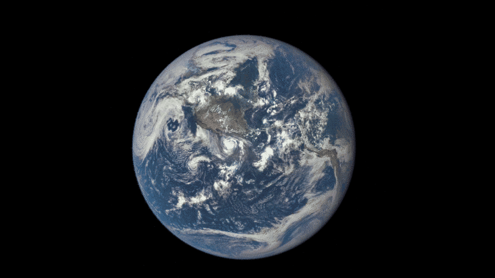
These images were taken between 3:50 p.m. and 8:45 p.m. EDT on July 16, showing the moon moving over the Pacific Ocean near North America. The North Pole is in the upper left corner of the image, reflecting the orbital tilt of Earth from the vantage point of the spacecraft.Image: NASA / NOAA
Landsat-8
Landsat-8, the update to Landsat-7, was launched in 2013, continuing the decades-long Landsat program. Having continuity in data is really important for scientists who study changes in Earth systems and Landsat products, available since the 1970’s, are often the only record available. Landsat 8 is much higher resolution as well, with most bands available at 30-meter resolution, and one high-resolution panchromatic band available at 15-meter resolution.
There’s more to come, too, despite past budgetary challenges to both NASA and NOAA earth science missions that thankfully did not pass. The SAGE III instrument will go up to the ISS later this year. If you’re anxious to know when, you can follow them on Facebook, where they’re promising to update with an exact launch date as soon as they get it. SAGE III is the newest iteration of SAGE (Stratospheric Aerosol and Gas Experiment), a series of ozone-detecting instruments that instruments have been critical in helping diagnose the extent of the ozone hole (though not in its original detection- quality control algorithms had rejected the data around the ozone hole for being too low). October will be an exciting month: CYGNSS is scheduled to launch then, focusing on ocean surface winds, as will GOES-R, a high-resolution weather satellite. In the slightly farther future, 2017 will see ICESAT-2 on the docket, with a goal of studying ice sheets, and JPSS-1, with a suite of weather and environmental monitoring sensors.