
 Explore Worlds
 Find Life
 Defend Earth


Mars: "Follow the Water" Is Not Dead

Written by
Ken Edgett
Senior Research Scientist, Malin Space Science Systems
May 26, 2009
Sometimes it is a bit awkward being a planetary scientist.
Say I'm getting my hair cut. The stylist will inevitably ask what I do for a living.
Unless I'm giving a public talk, I tend to be kind-of shy about telling people what I do.
"You wouldn't believe me if I told you," I'll say.
"Try me."
"Well, I work for a company that is operating a couple of cameras orbiting the planet Mars."
Silence.
I wonder: Should I go on?
Then I elaborate, "The company I work for builds cameras that go on spacecraft that explore Mars. We also operate some of them -- right here in San Diego. We also built cameras launching to the Moon next month, and we're working on a camera going to Jupiter in 2011."
Then I'll get one or both of the following questions about Mars: "Have they found water yet?" and, "Have they found life yet?"
To the latter, I usually answer, "If I told you, I'd have to kill you."
To the former, though, I'm usually more serious. "Yes," I'll say, "Mars has water. Actually, we've known this for decades."
In his 2004 proposal to build the Mast Cameras for the Mars Science Laboratory (MSL), my boss and colleague at Malin Space Science Systems, Mike Malin, wrote of the importance of water, saying: "Water: universal solvent, mediator of many chemical reactions, and fundamental component of geological systems on Earth. From its role at the molecular level, promoting and sustaining physical and chemical weathering processes, through its participation in the mechanisms of differentiation of silicate melts, to its dominance of erosion at the Earth's surface and the means by which sedimentary materials are transported and deposited to eventually form rock, water is as important in terrestrial geologic systems as it is in biology. It has been similarly important on Mars."
In other words, water is important on Mars, regardless of the astrobiology question. Water has been critical in shaping the landscape and in forming and altering some of the planet's layered bedrock.
Although astronomers speculated for more than a century about the presence of water on Mars—in the polar caps, in the dark areas (mare = sea, sinus = bay), and the "canals"—the first definitive detections of water vapor in the martian atmosphere were not reported until 1963. This was the result of two independent studies, one by Audouin Dollfus (Comptes Rendus de l'Académie des Sciences 256(2), 3009–3011) and the other by Hyron Spinrad, Guido Münch, and Lewis Kaplan (Astrophysical Journal 137, 1319–1321, doi:10.1086/147613). Infrared spectroscopic detection of water vapor in the martian atmosphere was difficult to accomplish, as it is hard to look up through an atmosphere full of water vapor (Earth's) in hopes of finding the same substance in the atmosphere of a neighboring planet. Observing at high altitude, and taking advantage of the Doppler shift of infrared light reflected from the red planet as Mars and Earth move relative to each other, helped these investigators resolve spectral features attributable to water.
As you know, we've learned quite a bit about water on Mars since 1963. The north polar residual cap has water ice, and the amount of water vapor in the atmosphere goes up each northern summer when this ice is exposed. The south polar region—we've learned from Mars Odyssey and Mars Express—also has some patches of exposed water ice during the summer. The two Viking orbiters carried the Mars Atmospheric Water Detector (MAWD), and daily global imaging by the Mars Global Surveyor (MGS) Mars Orbiter Camera (MOC) and Mars Reconnaissance Orbiter (MRO) Mars Color Imager (MARCI) show that water ice clouds are common over the landscapes of Mars, except during the most dusty times of the year.
Mariner 9 showed us vast outflow channels, thought to have been carved by catastrophic release of groundwater, and Mars Pathfinder landed in one of these areas and saw tell-tale signs—in the form of boulders stacked against each other—of these floods. Viking orbiter images helped clarify and elaborate upon the Mariner 9 story that Mars once had liquid water flowing across its surface, providing more detailed views of networks of small valleys. The Viking images also showed an array of mid-latitude landforms—such as aprons surrounding massifs east of Hellas, north of Arabia, and in the Phlegra and Erebus Montes regions—that were suggestive to some investigators of the presence and movement of ground ice, perhaps mixed with dust, sand, pebbles, cobbles, and/or boulders. Polygonal patterned surfaces at middle and high latitudes observed in pictures from the Viking orbiters and MGS contributed to the notion that ground ice may be present in these regions. The Mars Odyssey Gamma Ray Spectrometer (GRS) experiment further suggested the presence of high latitude ground ice because it detected an abundance of hydrogen within the upper meter of the regolith.
Meanwhile, near-infrared imaging spectrometers aboard Phobos 2, Mars Express, and the Mars Reconnaissance Orbiter (MRO) revealed the spectra of hydrated minerals on the planet's surface, and, in the early 1990s, investigators were extracting water from the minerals in meteorites thought to have come from Mars. MGS showed mid-latitude gullies, which for 10 years have been generating a lot of discussion among Mars scientists as to their origin and maintenance. MGS also showed solid (literally) evidence for an ancient, fossilized river delta in Eberswalde Crater, and the Mars Exploration Rover (MER), Opportunity, found evidence that acidic groundwater percolated through the ancient sandstones of Meridiani Planum, altering the chemical and mineral composition of the rock. And so on.
Throughout the past decade, you may have noticed many, many, many announcements about water on Mars—"NASA finds water on Mars"—"ESA finds water on Mars"—and so forth. I heard that last year they were even joking about this on late night television talk shows in the U.S.—and I almost spit my glass of water across the room last night when I viewed a recent episode of AMC's television show, "Breaking Bad," and they had characters talking about water on Mars!
A year and a day ago, the Phoenix Mars Scout lander touched down on the martian northern plains. Its robotic arm was used to dig down into the nearby regolith and scoop up samples that were found to include water ice. The Phoenix observations seemed to confirm—at least in the small area it investigated—the GRS team's interpretation that hydrogen is abundant in the northern high latitude regolith because this material contains water ice.
With the Phoenix results, and the repeated headlines in recent years about NASA, ESA, or "scientists" finding water on Mars, you'd think that the "Follow the Water" theme -- which has dominated NASA's Mars exploration activity for the past dozen (or so) years -- has run its course. I've certainly heard Mars scientists saying this. Didn't we follow the water, all the way down to the surface of Mars? Didn't we scoop up this water and examine it with Phoenix's analytical laboratories? And didn't the MER rovers find ample evidence for the effects of water on altering rocks and minerals at their respective landing sites? Aren't we done with "Follow the Water"?
Actually, we're not.
There are at least 3 key areas where I feel we're not done with "following the water":
(1) Has water ice played a role in forming or shaping the variety of mid-latitude landforms that some Mars investigators have attributed to ice? Such landforms include aprons surrounding massifs, lineated valley floors in the fretted terrains, concentric patterns in mid-latitude craters, roughened and pitted surface mantling materials, and a variety of "tongues" and "pasted-on materials" found on some mid-latitude slopes. We knew about some of these things from Viking, others were highlighted by the higher resolution images from MGS, Mars Odyssey, Mars Express, and MRO. We're currently using the cameras on MRO to test various hypotheses about these landforms, but what is missing is (a) very detailed geomorphological analyses of the images already on the ground and (b) a landed mission to investigate one or more representative mid-latitude landforms and look for ice.
(2) Were any of the sedimentary rocks found outcropping on Mars formed by deposition of sediment in an ancient lake? The MGS MOC revealed many places where there are dozens to hundreds of repeated beds of layered rock in craters and troughs, and the MRO HiRISE and CTX cameras have been following up on these observations. What kind of depositional settings do these rocks represent? Were any of them lakes? What about the range of other settings that have been proposed to be lakes, based on Viking orbiter images or even later data from MGS, Mars Odyssey, Mars Express, and MRO? Did ancient Mars really have lakes? If so, the sediment deposited in these basins will tell us much about what the environment of the planet was like in its earliest billion years or so. In some cases, these rocks may be older than the oldest rocks on Earth, and thus may also give us clues about the nature of early Earth, telling us something about the part of ourplanet's geologic record that is missing. The MER rover, Opportunity, may have found evidence for flowing water in the "smiles" (interpreted as ripples formed in flowing water) in the rocks of Eagle Crater, but we've yet to land somewhere that we can investigate strong candidate rocks formed of ancient lake sediment. Very high resolution imaging from orbit—say with images of about 5 centimeters per pixel—would be a great way to examine many of these layered rock sites without having to land at all of them, but, ultimately, landers/rover that can get into the small, tight areas where these rocks occur will be needed. The 2011 MSL rover has a shot at helping to answer this question if it goes to any one of three of its four landing site candidates (Gale, Holden, Eberswalde).

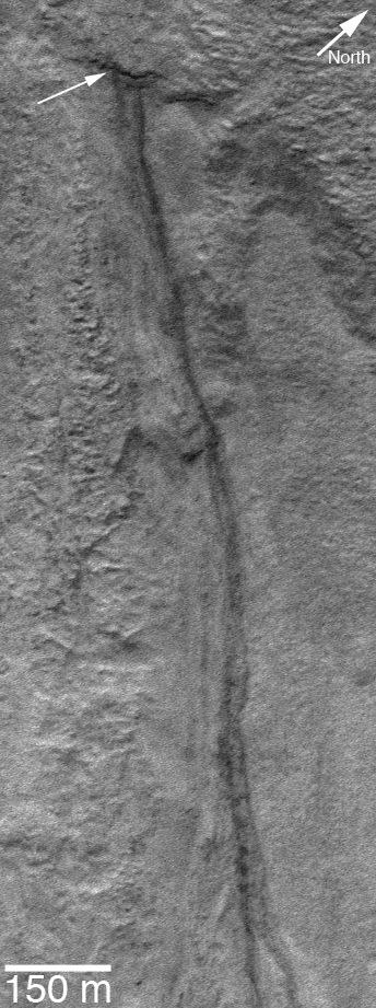
(3) Is there liquid water beneath the surface of Mars today? The mid-latitude gullies found a decade ago by MGS MOC are geologically young. Some are so young that no craters have formed on their channels and aprons, some of them cut through drifts of uncratered, windblown sand, and some have been changing in this decade as new flows have come through the channel systems and deposited new aprons of material. Others, MGS MOC and MRO HiRISE images have shown, are somewhat older -- some are cratered, some have windblown ripples in their channels, and so forth. The exciting thing is that some of them have been changing. Is liquid water the agent responsible for the change? Some have argued "yes," some have argued "no" (based on everything I've seen, I lean strongly toward the "yes" camp).
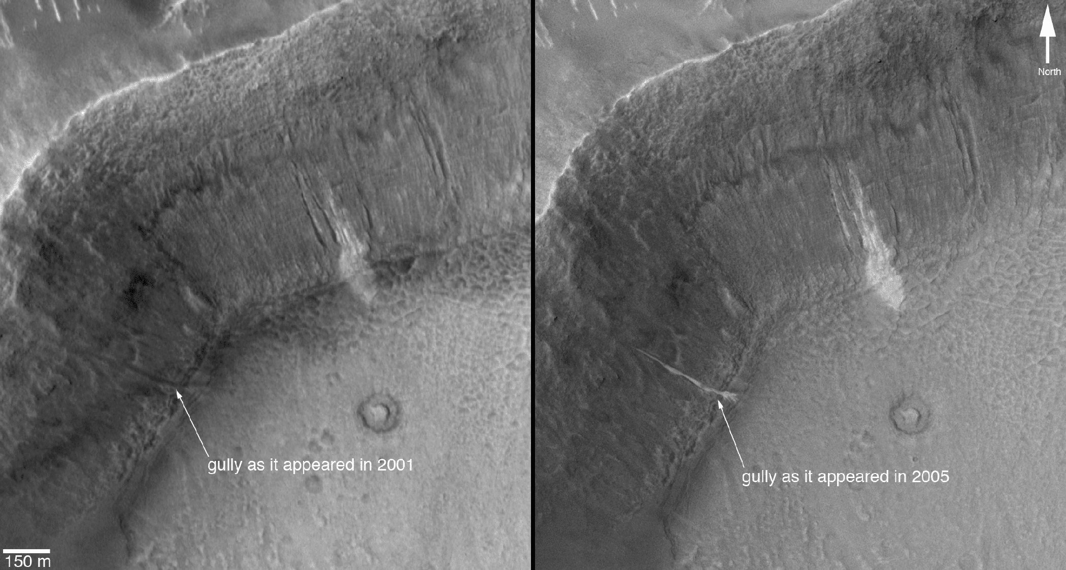
For all gullies, regardless of whether they've been changing or not, there is now 9 years of peer reviewed publications in which the debate shifts back and forth on whether water was involved (unfortunately, very few of these papers discuss the things actually observable in images of the gullies; most focus on modeling how they might have formed). For those that do believe that the data and/or their models show that liquid water was involved in forming and maintaining the gullies, what was the source of this water? Some argue that melting snow or ground ice is required, although I've never understood how the ground ice might melt (most gullies are nowhere near volcanic regions) nor how the slow trickle of snowmelt could carve the channels, keep the channels clear of debris, and move boulder-sized debris through the channels. Others have argued that groundwater is responsible -- that, despite (thus far) the lack of evidence for subsurface water in the radar sounding observations of Mars Express and MRO, there is some small amount of liquid water beneath the martian surface today, percolating through pores, cracks, and faults in the rock, occasionally coming to the surface and rushing down a crater wall, picking up debris along the way, and forming a lobe or apron of mud at the base of the slope. Whether that water is pure, or briny, or acidic -- who knows? An orbiter with a very high resolution imaging capability (e.g., 5 cm per pixel) would go a long way toward resolving some of the geomorphic questions about gullies and how they form -- the features related to their genesis are often just out of reach in terms of the MRO HiRISE image resolution; in addition, sending a rover or rovers to a gully site would be critical to understanding them, as well.
Mars is a complex world. We've only just begun to explore this planet, and there are many, many things we don't yet grasp. Frankly, the more I see from our Mars-orbiting cameras, the less I understand. But one thing is clear—we're not done following the water. At a minimum, we still have work to do in the areas of mid-latitude ground ice, characterization of ancient sedimentary rocks, and, most importantly, a thorough investigation (on the ground) of a gully site that has shown recent change.
We're not done "following the water" until we've sent a rover to a gully site and seen whether liquid water is still finding its way to the surface of Mars today.
And wouldn't it be fun to go find out?
Protect Our Shared Future
You help us defend humanity and prevent asteroid impacts. Donate now to become a Planetary Defender!
Donate