Emily Lakdawalla • Aug 22, 2014
Curiosity update, sols 697-726: Mars thwarts driving and drilling
When I wrote my previous Curiosity mission progress report, I anticipated that the month of August would see the rover making rapid westward progress through scenic valleys toward Mount Sharp. But Mars has a way of frustrating people's hopes, and the Mars gremlins worked overtime this month. First there was an anomaly with Curiosity's backup computer that had them sitting still for nearly a week while they checked it out. Then they found the sand within Hidden Valley to be much more slippery than expected, and had to reverse course. Finally they made an attempt to drill, but the rocks shifted under the drill and they decided it wasn't safe to keep trying there, or worthwile to find another site; better sites await them down the road. It's all a reminder that Mars is hard. I could do with fewer reminders of that! The mission is carrying on undaunted, and now plans to skirt the northern edge of Hidden Valley before trying to enter the sandy valleys in another location, hopefully one with less-deep sand.

A JPL press release dated August 5 summarizes the computer problem:
Another recent challenge appeared last week in the form of unexpected behavior by an onboard computer currently serving as backup. Curiosity carries duplicate main computers. It has been operating on its B-side computer since a problem with the A-side computer prompted the team to command a side swap in February 2013. Work in subsequent weeks of 2013 restored availability of the A-side as a backup in case of B-side trouble. In July, fresh commanding of the rover was suspended for two days while engineers confirmed that the A-side computer remains reliable as a backup.
Unexpected challenges while driving in sand prompted the mission to reverse course last week after entering a valley where ripples of sand fill the floor and extend onto sloping margins....
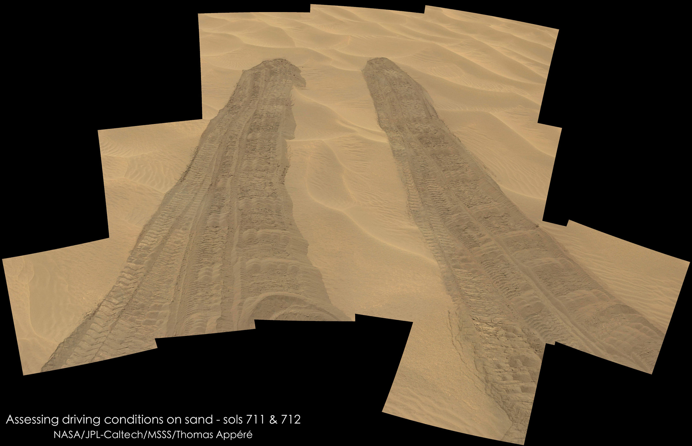
The rover's wheels slipped more in Hidden Valley's sand than the team had expected based on experience with one of the mission's test rovers driven on sand dunes in California. The valley is about the length of a football field and does not offer any navigable exits other than at the northeastern and southwestern ends.
"We need to gain a better understanding of the interaction between the wheels and Martian sand ripples, and Hidden Valley is not a good location for experimenting," said Curiosity Project Manager Jim Erickson of JPL....
In some sandy areas, ripples don't cover the ground deeply wall-to-wall, as they do in Hidden Valley. Curiosity reversed course and drove out of Hidden Valley northeastward.

I want to make it very clear that the rover was never in danger of embedding in the sand in Hidden Valley. They expected a certain amount of slip when driving across sand, but had safeguards in place to allow the rover to check and automatically terminate driving operations when it detected its wheels slipping more than was safe. I asked Ashwin Vasavada for a little more information on just how much they were slipping, compared to what they would have considered a safe amount of slip. He answered:
We got a maximum of nearly 80% slip on the Hidden Valley sand, toward the end of the drive. Slip varied quite a bit over the drive and in some cases was negative, meaning that as expected, the rover skids slightly when descending ripples.
There isn't a single threshold value. Rather, onboard safety parameters are set for the particular material, drive geometry, and other factors. Visual odometry carefully tracked the drive and aborted it when these safety thresholds were reached. Some tens of percent of slip was in the realm of possibility for the drive, but the actual slip was beyond expectations.
On the way out of Hidden Valley, they noticed that they happened to drive over a small area of flat rock that could be their first opportunity to drill some Mount Sharp related rock. Unfortunately, that effort ended in frustration, too. Here's the description of the drilling challenges, in a press release issued today:
Evaluation of a pale, flat Martian rock as the potential next drilling target for NASA's Curiosity Mars rover determined that the rock was not stable enough for safe drilling.
The rock, called "Bonanza King," moved slightly during the mini-drill activity on Wednesday, at an early stage of this test, when the percussion drill impacted the rock a few times to make an indentation.
Instead of drilling that or any similar rock nearby, the team has decided that Curiosity will resume driving toward its long-term destination on the slopes of a layered mountain. It will take a route skirting the north side of a sandy-floored valley where it turned around two weeks ago.
Ashwin expanded upon this a little bit in an email to me: "we hoped they were connected to each other underground or at least tightly embedded. But no dice, so we are moving on."
Why, you might ask, did they try drilling in the first place? More information is contained in the August 15 release, if you read between the lines:
This summer, Curiosity's team has developed a plan for compressing the multi-day schedule of rover activities involved in collecting a drilled rock sample and delivering the sample for onboard analysis. This "condensed drilling" plan requires adjustment of staffing levels for several days, due to the complexity of the rover activities involved. The needed staffing had been slated for mid-August in anticipation of getting to Pahrump Hills.
"We considered postponing the first condensed drilling, and we considered other possible drilling targets, but this outcrop on the ramp is too appealing to pass up," Vasavada said.
One step in assessing whether Bonanza King can be drilled will be to check whether the individual plates of the outcrop are loose. During the drilling campaign, the team will also be analyzing possible routes to Mount Sharp and planning how to better understand how the rover's wheels interact with Martian sand ripples.
Basically, they had scheduled drilling staff to try out a new type of condensed drilling operations for the time they expected to be drilling, and couldn't predict it would take so long to get to the Pahrump Hills site they'd identified earlier. The combination of the backup computer anomaly and the Hidden Valley driving challenges significantly delayed their arrival at a region that they hoped would be rich with drill sites. Bonanza King was worthwhile scientifically ("appealing"), and would allow them to test out their new "condensed drilling" mode, but the August 15 release tells you that they already considered it marginal in terms of drilling safety; they proceeded with appropriate caution. It was a gamble (of time, not rover safety, they don't gamble with that), and they lost their bet that Bonanza King would be a stable drilling site. And unfortunately, Ashwin says, "There are no better targets of the same stuff around here."
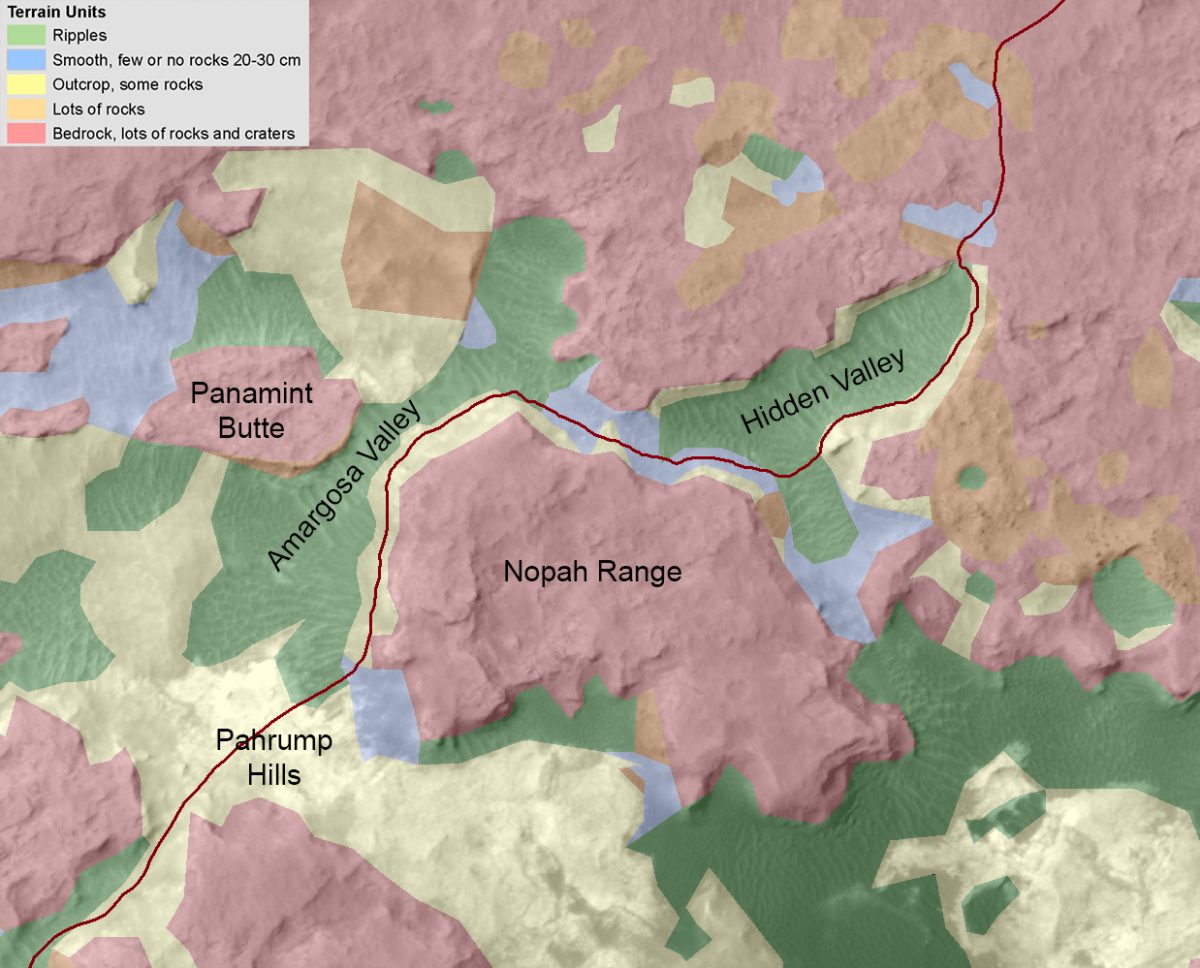
The next step is to drive along the north edge of Hidden Valley, trying for an alternative route to Pahrump Hills. It's not where they wanted to drive -- there's a lot of the "red" terrain they want to avoid with the wheels -- but there are bits and pieces of safer terrain and they'll no doubt pick their way from lily pad to lily pad and then find a location to descend into the Amargosa Valley. Here is a map that Ashwin showed during his public talk, which gives you an idea of what they will try to do. They want to avoid red terrain and drive on blue (smooth, without ripples) and yellow (flagstone-like) terrain as much as possible; both those terrains produce little to no wheel wear.

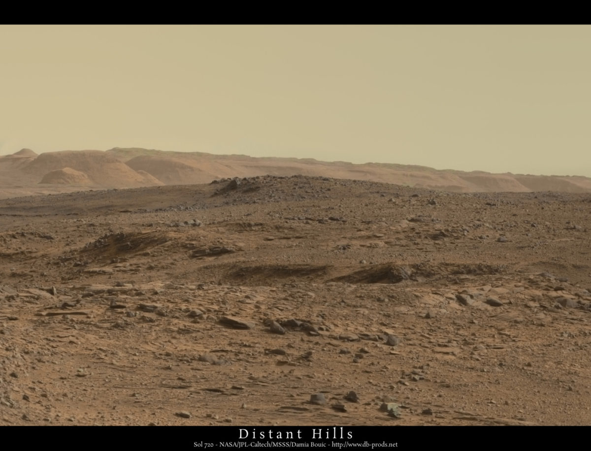
All in all, a frustrating month; but life, and Mars missions, go on. Curiosity will make progress in her own time. And there are worse places to be frustrated. Just check out the view:

For the gory detail on the last month of activities, here are all the relevant updates from the USGS astrogeology website.
Sol 697 - 698 Update from Ryan Anderson: Holding Off (24 July 2014)
No science uplink was sent to the rover for sol 697 or 698 because the engineers are investigating an issue with the rover's backup computer. The primary computer used in day-to-day operations is healthy, but we are holding off on science operations until we are sure the backup is healthy, just to be safe. The blog will resume when we start science operations again.
Sol 703 Update from Ken Herkenhoff: In a Better Position (28 July 2014)
After the 13-meter drive on Sol 702, MSL is in a better position to see the terrain ahead. But the front wheels are perched on rocks, so it is not safe to deploy the arm. Therefore, I didn't have much to do as MAHLI/MARDI PUL1 today, just the normal post-drive imaging. Because the view ahead is better, a longer drive is planned for Sol 703. We planned pre-drive Mastcam and ChemCam observations of targets Andrews Mountain and Cuzcatlan and after the drive, a Mastcam mosaic of the valley in front of us.
Sol 704 Update from Ken Herkenhoff: Off-Planet Driving Record (29 July 2014)
I should have mentioned yesterday that the Opportunity rover recently broke the off-planet driving record that was previously held by the 1973 Lunokhod 2 lunar rover. It will be a long time before the 40-km record is broken, even at the rate MSL is moving. But Curiosity made almost 30 meters of progress on Sol 703, ending up in a location with a nice, smooth area in front of the rover, well-suited for dumping the sample from CHIMRA. But, as shown in the same Front Hazcam image, the right front wheel is again perched on a rock, so there was a lot of concern about stability during arm activities. This made planning complicated, as we had to prepare contingency activity plans while rover stability was evaluated. Ultimately, the result of the slip risk assessment process was that arm activities were approved, and we plan to dump the sample on Sol 704. As MAHLI/MARDI uplink lead again today, I focused on the plan for MAHLI imaging of the dump location before and after dumping the sample. ChemCam and Mastcam observations of nearby rock targets Thimble and Resting Spring are planned after the APXS is placed on the dump pile.
Sol 705 Update from Lauren Edgar: Hidden Valley (30 July 2014)
Today we are planning Sol 705, and Curiosity is just about to drive down from the Zabriskie Plateau into Hidden Valley, where the terrain should be much easier to traverse. The Sol 705 plan includes a bump towards targets named Resting Spring and Thimble, to prepare for contact science tomorrow. It will be a good chance to understand the hard, angular, cap rocks that create the rough terrain that we’ve been driving across. The plan also includes ChemCam LIBS of a target called Poleta, which we hope to analyze with APXS tomorrow, as well as ChemCam and Mastcam observations of the Windjana dump pile (a sample from The Kimberley, which we finally dumped yesterday). There are also a number of Mastcam and ChemCam RMI observations to document the local geology.
Sol 706 Update from Lauren Edgar: Scenic Route (31 July 2014)
Today we planned contact science (APXS and MAHLI) on a rock target named Thimble, and an extra MAHLI image of an adjacent rock named Poleta. These observations will give us good chemical and textural information for the rocks that we’ve been driving across. We also planned a ~30 m drive down into Hidden Valley, with additional ChemCam and Mastcam observations of a blind target, and standard post-drive imaging. We’re looking forward to some beautiful scenery in the coming weeks as we work our way through the valleys.
Sol 707 Update from Lauren Edgar: Entering the Valley (1 August 2014)
Curiosity has just entered Hidden Valley! For a view into the valley and information about our plans for exploring the geology, check out the recent press release. Today’s 3-sol plan is a busy one, including ChemCam observations on a disturbed soil target in a wheel track (Saline Valley), an undisturbed soil (Redlands), and contact science on a rock named Stirling. We also planned a number of MAHLI images, including the rock Stirling and another disturbed soil target named Mule Spring, along with APXS on the soil. In addition, we planned a number of Mastcam mosaics on the walls of Hidden Valley, and a drive into the valley. Another great day on Mars!
Sol 710 Update from Ken Herkenhoff: Deep Tracks (4 August 2014)
The Sol 709 drive was not as long as planned because the minimum 2 meters of progress out of 4.5 meters commanded was not achieved. This software check may be disabled for future drives across sandy material, to allow more slippage before the rover stops driving. The Sol 710 plan includes Mastcam mosaics of the walls of the valley the rover is in, and a ChemCam observation of a target dubbed Desert Range near the right edge of the rover track seen here. Then the rover will drive a few meters back along its tracks and take the standard post-drive data. I was MARDI/MAHLI uplink lead today, and helped plan some ChemCam RMI calibration observations as well.
Sol 711 Update from Lauren Edgar: Slippage (5 August 2014)
Curiosity is still at the northern end of Hidden Valley. The past few drives have experienced some slip, so we are collecting data to investigate how the wheels are interacting with sand, and considering a number of drive strategies. This Navcam image from Sol 710 shows some of the progress we made into the ripple field before we decided to back up. The plan today includes a pre-drive targeted science block, MAHLI wheel imaging, a drive, post-drive imaging for targeting, and an afternoon untargeted science block. The morning science block includes ChemCam and Mastcam observations of a light-toned rock named Gold Ace, and the afternoon block includes another blind ChemCam target. The next few sols will be rapid traverse sols.
Sol 712 Update from Lauren Edgar: Rover-Sand Interaction (6 August 2014)
Curiosity is still at the northern end of Hidden Valley, and the rover planners are trying to decide on the best approach for upcoming drives. The plan today consists of Mastcam observations to characterize the local geology, as well as some extra images to understand rover-sand interactions. This MAHLI image from Sol 711 shows the wheels interacting with sand. The plan also includes Mastcam observations of the transit of Mars’ moon Phobos. The next few sols are scheduled as rapid traverse sols.
Sol 713 Update from Ryan Anderson: High Road or Low Road? (8 August 2014)
The plan for Sol 713 is to do some brief ChemCam and Mastcam observations of a target called Thorndike, and then drive. The goal of the drive is to move the rover a short distance back in the direction we came from to get out of the sand that has been causing driving difficulties recently. Once we’re on more stable ground, we will weigh science and engineering considerations and decide what our driving strategy will be: do we keep trying to drive in the sand in Hidden Valley, or do we drive on the rocky surface of Zabriskie plateau?
Sol 714 Update from Ryan Anderson: On Solid Ground (10 August 2014)
The Sol 713 drive got us out of the sand and onto solid (albeit rocky) ground! For Sol 714, the plan is to drive the rest of the way out of Hidden Valley to a slight high point in the terrain so that we can take pictures for route planning. Before the drive on sol 714, there is a ChemCam blind observation and a Mastcam observation of a target called Harkless. During the drive, there will be a pause for some mid- drive imaging of the rover’s tracks. And then on sols 715 and 716 the rover will be in planned runout mode, meaning it will just make routine environmental measurements.
Sol 717 Update from Ryan Anderson: Vantage Point (11 August 2014)
The sol 714 drive was successful and the rover traveled 37.5 meters to the vantage point we were aiming for. For the Sol 717 plan, we’re planning to drive the rover back to the entrance of Hidden Valley to investigate possible drilling locations. Before the drive there will also be a Mastcam observation of the entrance to Amargosa Valley. Science-wise, the sol 717 plan has ChemCam and Mastcam images of the target Pogonip, a ChemCam LIBS analysis of a target called Greenwater, and Mastcam stereo of the Greenwater region. We also have a ChemCam blind observation after the drive, along with other routine measurements.
Sol 718 Update from Ken Herkenhoff: Conducting Baseline Tests (12 August 2014)
Planning is "restricted" this week again (Sol 717 post-drive data will not be received until late this afternoon), so only untargeted observations are planned for Sol 718. For example, Mastcam and ChemCam will observe the sky and calibration targets on the rover, and CheMin and SAM will conduct baseline tests.
Sol 719 Update from Lauren Edgar: Second Anniversary Webcast (13 August 2014)
Curiosity is at the northern end of Hidden Valley, and we are preparing for condensed drilling on the target Bonanza King. Condensed drilling means that we will attempt to acquire a drilled sample with high efficiency – including bumping to the target, characterizing the target, drilling and transferring the sample. Bonanza King is part of a light-toned, potentially fine-grained outcrop. When Curiosity drove over Bonzana King on a previous sol, we exposed a fresh rock face. The plan today includes several ChemCam observations to characterize the drill target, a bump to the drill location, and some post-drive imaging to prepare for contact science.
In celebration of the 2nd anniversary of MSL's successful landing on Mars, Ashwin Vasavada (MSL Deputy Project Scientist) will be giving public lectures on Thursday and Friday. If you can't travel to Pasadena for either of the lectures, they will be broadcast on the web.
Sol 720 Update from Lauren Edgar: Looking for Clouds (14 August 2014)
Today is a restricted sol, so we are planning a number of untargeted observations. Curiosity should have bumped on Sol 719 to put the condensed drilling target Bonanza King in the work volume, and we are waiting for those data to come down. The Sol 720 plan includes a Mastcam and Navcam photometry experiment to characterize differences in lighting over the same region at different times of day, and a ChemCam blind observation. The plan also includes a couple of ChemCam RMI mosaics to characterize the local geology, and Mastcam imaging to monitor the sand ripples in Hidden Valley. There are also several environmental monitoring activities, including standard REMS and RAD observations, Navcam imaging to look for any clouds related to Mt. Sharp, and Navcam imaging to search for dust devils.
Sol 721 from Ryan Anderson: Bonanza King (16 August 2014)
We’re gearing up for our fourth drill hole on Mars! For the sol 721 plan, we have a long block of time dedicated thoroughly analyzing the drill target Bonanza King. During this block, we will analyze 25 points on the target with ChemCam in a 5x5 grid, and follow up with Mastcam images of Bonanza King using multiple different filters (we call images like this that use multiple different filters multispectral images). Mastcam will also take multispectral images of targets Millers Spring and Smokey, plus a mosaic of the south wall of Hidden Valley to cover an area that previous mosaics did not.
Sol 722 will be dedicated to contact science on the drill target, with MAHLI images and APXS measurements. The rover will also collect data to make sure that it is in a stable location for drilling, brush the drill target, and test placing the drill on the target and pre-loading it. Pre-loading is another term for “pushing” and is necessary for the drill to work: If you have ever done home improvements and had to drill into wood, you know that you have to push to get the drill bit to bite into the wood. The same idea applies to Curiosity’s drill, and we do the pre-load test to make sure the target doesn’t move when the rover pushes on it.
After the complicated sol 721 and 722 plans, sol 723 will be a simple sol with just some environmental monitoring.
Sol 724 Update from Ryan Anderson: Mini-Drill Hole (18 August 2014)
Everything went well over the weekend, and the drill target seems to be nice and stable, so for the Sol 724 plan, Curiosity will do a “mini-drill” into Bonanza King. This activity is complicated enough that there wasn’t much of a chance to do any science observations other than those that support the drilling, except for standard DAN and REMS environmental monitoring. The mini-drill activity does basically what it sounds like: it drills just a little bit into the target. We do this to make sure the rock characteristics are safe for a full-depth drill hole. One step closer to a 4th full drill hole on Mars!
Sol 725 Update from Ryan Anderson: Zapping Targets (19 August 2014)
We are still looking forward to data from sol 724’s mini-drill experiment, and since we don’t have that yet, we can’t do the full drill in the sol 725 plan. So instead, we are doing a remote sensing day on sol 725, which means lots of Mastcam and ChemCam. ChemCam will be zapping four targets: the tailings from the mini-drill on “Bonanza King”, plus targets “Carrara,” “Perdido,” and “Lee Flat”. Mastcam will be taking documentation images of those targets, plus a mosaic of the target “Lone Pine” and a photometry experiment to measure how sunlight reflects from the martian soil at different illumination angles. There are also some Mastcam images of the sun to measure the amount of dust in the atmosphere, and Navcam will be looking for clouds over Mount Sharp. Meanwhile, CheMin will be getting ready to ingest some of the drilled rock powder by rotating an empty analysis cell into position.
While we wait for pictures of our mini-drill results, I highly recommend that you take a look at this post on Curiosity’s wheel damage by Emily Lakdawalla of the Planetary Society. I found it useful even as a MSL team member because it distills a lot of information into one place.
Let’s Go Beyond The Horizon
Every success in space exploration is the result of the community of space enthusiasts, like you, who believe it is important. You can help usher in the next great era of space exploration with your gift today.
Donate Today

 Explore Worlds
 Find Life
 Defend Earth

