
 Explore Worlds
 Find Life
 Defend Earth


Mars Exploration Rovers Update: Opportunity Departs Cape York, Breaks Apollo Record
Sols 3295 - 3325

Written by
A.J.S. Rayl
Contributing Editor, The Planetary Society
June 5, 2013
Mars Exploration Rover
NASA / JPL-Caltech / Maas Digital
It was a merry and mighty month of May for the Mars Exploration Rover mission: Opportunity finished a blockbuster study of Matijevic Hill finding the best evidence yet for an ancient, potentially habitable environment, and then embarked on its first real road trip in two years. The robot field geologist had barely gotten underway on its journey when it surpassed the Apollo 17 lunar rover distance record to become the most traveled NASA vehicle on another planetary body.
Opportunity is now heading south for the coming Martian winter. It's taking a fairly straight-forward route to a winter haven at Solander Point, another segment on Endeavour Crater's western rim about 2 kilometers (about 1.4 miles) away. "I call it our winter sprint," said Scott Lever, MER mission manager at the Jet Propulsion Laboratory (JPL), home to all the American Mars rovers. "We're going to a location on the northwestern tip of Solander Point, where there is a wide expanse of northerly hills, with slopes of 15 degrees or greater."
Because of its age and the amount of dust that has accumulated on it in the last nine years, the solar-powered rover must position itself on a north-facing slope and angle its arrays to the winter Sun in order to take in the maximum amount of sunlight "fuel" to survive and keep working throughout the harsh season.
Despite more than nine years of roving and a few broken parts, Opportunity is indeed sprinting, knocking off 90+-meter drives on some sols. "It's great to be doing these long drives," said Ashley Stroupe, MER rover planner, one of Opportunity's drivers. "We're making really good progress. And, we're driving past interesting stuff and getting beautiful images of different rocks and formations down every day."
Another drive, a new NASA record
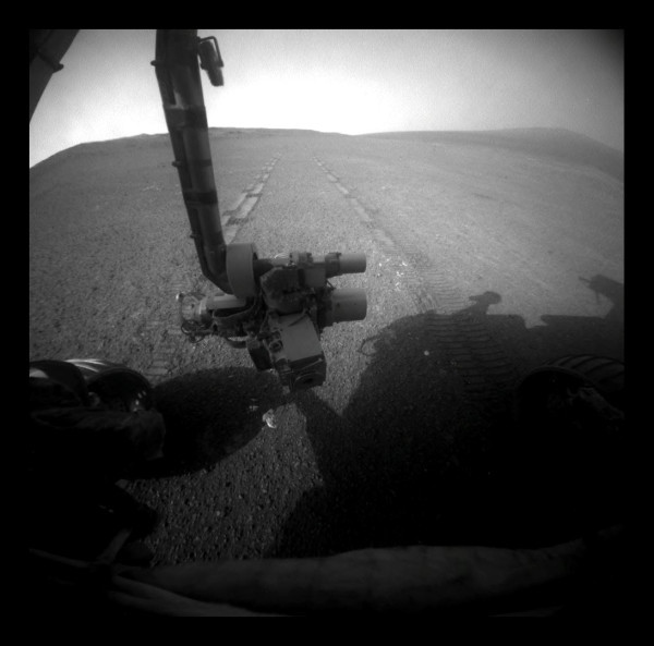
On Sol 3309 (May 15, 2013), Opportunity drove 80.25 meters (263.29 feet) southward along the western rim of Endeavour Crater, putting the rover's total distance driven since landing on Mars in January 2004 at 35.760 kilometers (22.220 miles). That drive took the rover past the previous distance record for a NASA vehicle on a world other than Earth, the mark of 35.744 kilometers (22.210 miles) set by the astronaut-driven Lunar Roving Vehicle of the Apollo 17 mission to Earth's moon in December 1972. The rover took this picture with her front hazard-avoidance camera after the record-breaking Sol 3309 drive, looking back at the tracks she produced while driving backwards, as it often does.NASA / JPL-Caltech / Stuart Atkinson
Actually, the rover has been driving so well that the MER team decided in late May that it could afford to take a slight diversion off the fast path to check out a small crater, and take pictures of a circular hill of interest, Nobby's Head.
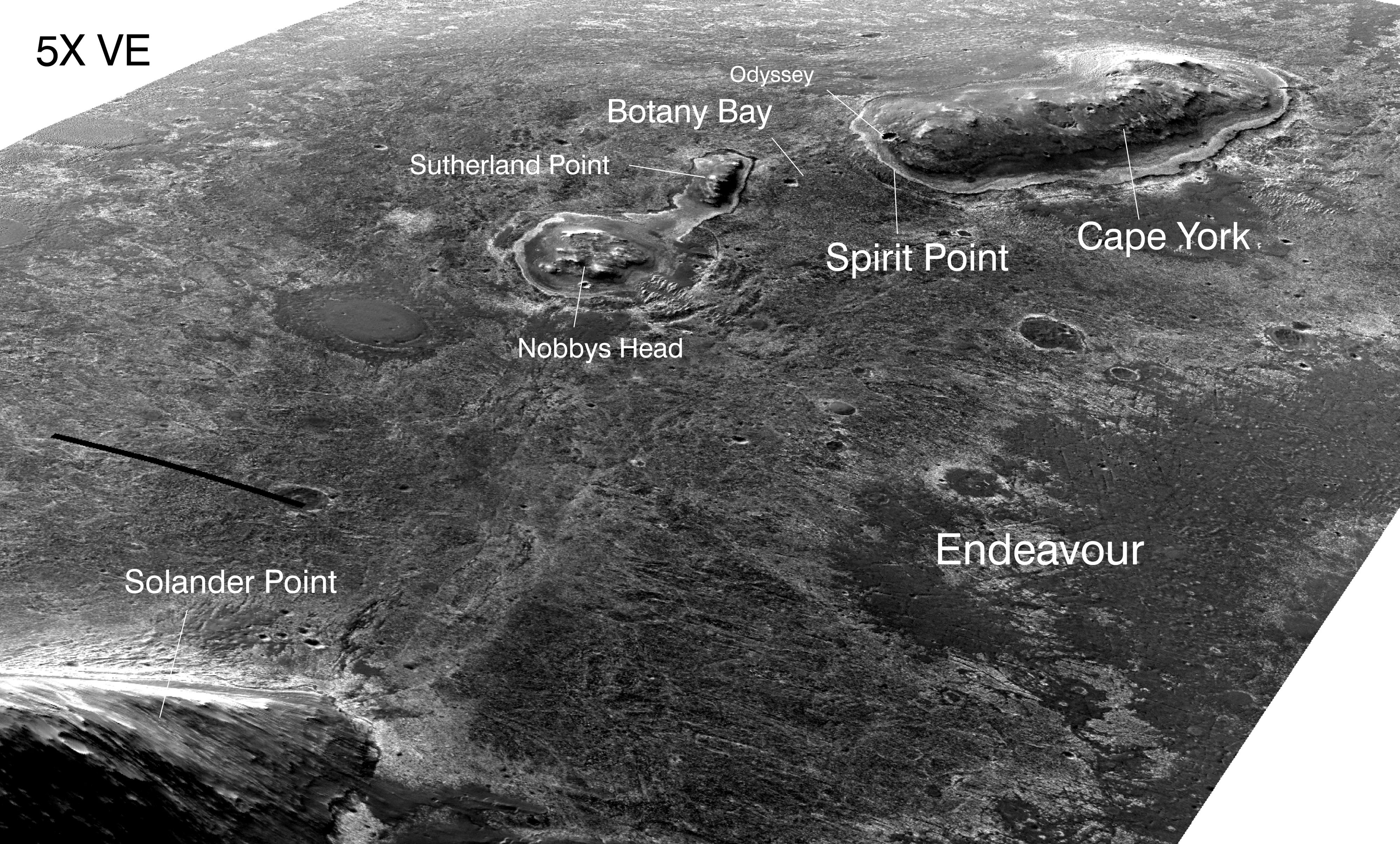
Since first crossing from the Meridiani Plains onto the rim area of Endeavour Crater nearly two years ago, Opportunity has been exploring the Cape York segment of the crater's western rim. The 22-kilometer (about 13.7-mile) crater is the oldest this rover has visited. It dates back to the Noachian Period on Mars 4.1 to 3.7 billion years ago, a time when meteorites and asteroids were constantly impacting the surface, and water flowed on and under the surface.
Using the stratigraphy or layers of rock as a kind of time machine, Opportunity went back to that ancient epoch at Cape York, and a jumble of other time periods that followed. Week to week, it sent home pictures of rocks and things, some seemingly familiar, and strange Martian oddities they'd never seen before.
For the last 10 months, Opportunity has been roving through a treasure trove of geologic formations on Matijevic Hill, a small rise along the inboard side of Cape York. "We found the most interesting rocks we've ever seen on Mars there," said Ray Arvidson, MER deputy principal investigator, of Washington University St. Louis. The MER scientists also found what they were looking for.
Matijevic Hill is the "sweet spot" of the area in Cape York where the Compact Reconnaissance Spectrometer for Mars (CRISM), onboard the Mars Reconnaissance Orbiter (MRO), had detected phyllosilicates, specifically smectite clay minerals, according to a pixel-by-pixel map Arvidson made. Within the last couple of months, the robot geologist and her science team homed in on one specific rock unit, dubbed Whitewater Lake, as the strata where those clay minerals are ensconced, effectively ground-truthing CRISM's discovery.
That and other evidence began to turn back the pages of time to reveal an ancient Martian environment at Endeavour where water flowed, and an ancient Mars that is beginning to look more and more like Earth. [See: Mars Exploration Rovers Special Update: Opportunity's Findings at Endeavour, So Far]
As May blew in on Mars, Opportunity was wrapping up work on its final target on Matijevic Hill. The rover actually had been positioned for weeks over the spot called Esperance on the greater Whitewater Lake rock unit. Located in the strata the MER scientists had already concluded harbored the clays, the target was particularly compelling. The scientists seemed certain that Esperance had something significant to tell them and they wanted to know what it was. Time however was of the essence.
NASA / JPL-Caltech / Cornell / Arizona State University
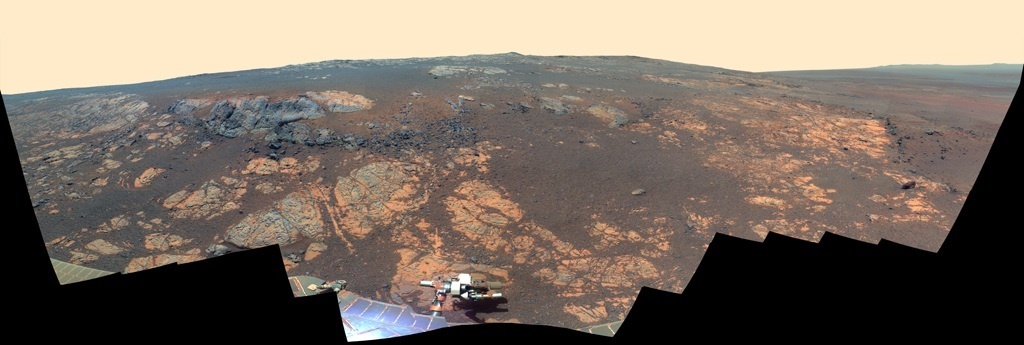
Good-bye Matijevic Hill
Opportunity took the hundreds of component images for this panorama with her stereo panoramic camera (Pancam) from Nov. 19, 2012 through Dec. 3, 2012. Named in honor of JPL's Jake Matijevic, one of the creators of Spirit and Opportunity and a Mars rover pioneer, the hill is an area in the Cape York segment of Endeavour Crater's western rim. Jake passed away on Aug. 20, 2012, shortly after Curiosity landed. The rover has spent the last 10 months exploring Matijevic Hill, and when her work was done, the mission had not only found the phyllosilicates (clay mineral smectites) it had hoped to find there, but also the most convincing evidence yet that long, long ago water flowed in a potentially habitable environment around Endeavour Crater.Opportunity had to leave Matijevic Hill no later than the middle of May if it was going to reach its winter haven by early August, the arrival timeframe JPL engineers established so that the rover would have plenty of time to find the right place to hunker down. But, as Squyres put it: "Esperance was so important, we committed several weeks to getting this one measurement of it, even though we knew the clock was ticking."
So the robot field geologist got back into work on Esperance right away, analyzing its elemental chemistry with its alpha particle X-ray spectrometer (APXS). At the same time, word came from Bruce Cantor over at Malin Space Science Systems (MSSS) that a storm was brewing and could come perilously close to Opportunity. MSSS collects data with its Mars Color Imager (MARCI) onboard MRO and offers weekly weather reports from Mars on its website. "We were worried," noted Bill Nelson, chief of rover engineering at JPL. "This is Mars."
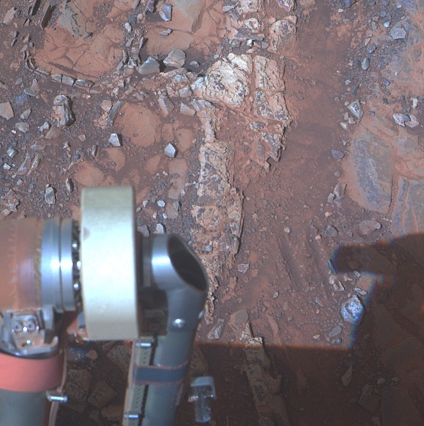
Esperance
The pale rock in the upper center of this image, about the size of a human forearm, includes the target in this Whitewater Lake outcrop called Esperance. Opportunity studied Esprance with its alpha particle X-ray spectrometer (APXS) and from the data it sent home, scientists were able to determine that Esperance's composition is higher in aluminum and silica, and lower in calcium and iron, than other rocks the rover has examined in more than nine years on Mars. On May 17, 2013 NASA-JPL announced that Esperance was composed of clay minerals due to intensive alteration by water, concluding what turned out to be a blockbuster 10 months on Matijevic Hill. The view is presented in false color to make differences between materials easier to see.NASA / JPL-Caltech / Cornell / ASU
To the mission's good fortune, the storm stayed safely to the west of Opportunity, but the dust it whipped up darkened the skies over Endeavour. Even so, the rover finished its work at Esperance in the nick of time and began the trek south to Solander on May 14th. The following sol, on just its second drive into the long journey, the MER put 80.25 meters (263.29 feet) on its rocker bogie and set a new distance record for a U.S. rover.
"This drive broke the official Apollo 17 odometry record of 35.744 kilometers* (19.3 nautical miles or 22.21 statute miles) by 16.13 meters," informed Nelson. "That is the longest odometry for Apollo 17 in any numbered NASA document and is therefore taken as the official odometry," he added.
The Apollo 17 rover record stood for 40 years and 213 days, as Mike Seibert, a MER mission manager at JPL, figured it. It was set by human astronauts Eugene Cernan and Harrison Schmitt in December 1972, driving the mission's Lunar Roving Vehicle.
"The record we established with a roving vehicle was made to be broken, and I'm excited and proud to be able to pass the torch to Opportunity," Cernan told MER science team member, Jim Rice.
The rover that loves to rove is now the most traveled NASA vehicle on another body. "It's another step forward and another milestone by which we can measure our progress," said John Callas, MER project manager, of JPL. "We're all extremely proud," added Stroupe. "We're really thrilled."
Even Mars applauded. Although the sky predictably began to clear by raining dust, some of which was landing on the rover, a series of small gusts that lagged behind the storm whisked by and dusted the rover's solar array. During the third week of May, that dusting helped give the rover a notable boost in energy.
"There are two effects here," John Callas, MER project manager, of JPL, pointed out. "At the same time there was the drop in the atmospheric opacity we had the dust-cleanings. Those two together, combined, gave us that boost of energy," he clarified.
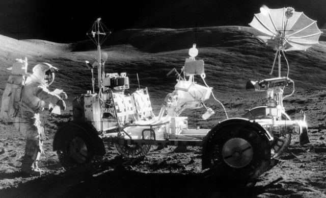
Apollo 17 Lunar Rover Vehicle
In December 1972, NASA astronauts Eugene Cernan and Harrison Schmitt drove their Apollo 17 Lunar Rover Vehicle for 35.744-kilometers or 22.210-statute miles to set a record for the space agency's most traveled rover. On May 15th, Opportunity, which is driven remotely by humans on Earth, surpassed the Apollo 17 record with a drive 80.25 meters (263.29 feet), bringing its total odometry since landing on Mars, in January 2004, to 35.760 kilometers (22.220 statute miles). The MER still has several hundreds of meters to go to pass the Lunokhod 2 record, to become the international champ.NASA
With the next Martian winter looming on the horizon, there was barely time for the MER ops team to high-five the rover's newest record. Opportunity still has one more record to break to become Earth's most traveled rover. Lunokhod 2, the Soviet Union's robotic lunar rover that traveled 37 kilometers (22.99 miles) on the surface of Earth's Moon in 1973. But the MER is closing in fast to take the 'gold.'
"Driving is the order of the day," said Nelson.
Opportunity put her pedal to the metal during the second half of May, finally clearing Cape York proper on May 23rd - "it was something like getting out of L.A., but without the traffic," said Nelson" - and then roving onto the Bench, the apron area surrounding Cape York. It stopped there long enough to take some good photographs, then moved on, heading south, southwest.
From the Bench, Opportunity headed into Botany Bay, a tilted plains surface, from which a circular hill called Nobby's Head and Sutherland Point rise up as isolated remnants of Endeavour's highly eroded rim. With its vigorous drives, the rover managed to put the mission ahead of schedule. "We've been slightly beating the average distance that we expected to drive each sol," confirmed Nelson. "We also have some contingencies in place, so we're slowly building a little additional margin."
As a result of that built-up margin, Opportunity diverted slightly from "the rapid transit route," as Arvidon's dubbed it, to conduct a "drive-by shooting" of a crater called Venera, At month's end, the rover was between Sutherland Point and Nobby's Head, the circular hill where the team decided to make a pit stop. "We'll do stereo-imaging at Nobby's Head, because, based on orbital images, it's a possible bail-out for the winter," Arvidson said. "If there's some engineering emergency or something unexpected that happens, we always want to have a back-up plan."
The only thing that seemed to hold Opportunity back from driving even more in May was the reality of limited memory: the rover was filling up its Flash faster than it was getting the data downlinked. The rover's Flash holds under 1500 megabits of memory. "We filled it up with all sorts of data," said Nelson. From auto navigation imaging, a mode where the rover drives itself, to 360-degree navigation camera images and panoramic camera shots of interesting geologic features it will likely never be by to see again, the rover was down to less than 250 megabits of free space.
So, over the American Memorial Day holiday weekend, Opportunity took a break from driving to downlink several hundreds of megabits of data and free up her Flash, and it downlinked more data during the last week of the month.
Then, Opportunity drove out of May. All told, the rover logged more than 700 meters in the two weeks since beginning her journey south. "As I like to stress, it's not how far we've driven but how much science and exploration we've done," noted Callas.
In May 2013, however, Opportunity did it all, producing what is one of, if not the mission's greatest scientific discovery in nine years and four months of exploration, driving far enough to break the Apollo 17 rover distance record, with just 625 meters to go to surpass the Lunokhod 2 distance record. "If all goes well, we'll be breaking the record from Lunokhod 2 on our way to Solander," said Stroupe.
Opportunity's trekking grounds
This image, taken by the HiRISE: High Resolution Imaging Science Experiment onbaord the Mars Reconnaissance Orbiter (MRO) is labeled to show Opportunity's most recent neighborhoods and the neighborhood to which it is now roving, Solander Point. The robot field geologist will be spending its sixth winter on a north-facing slope there.NASA / JPL-Caltech / UA
Solander Point is the next chunk of rim fragment to the south of Sutherland Point, and somewhere there the rover's winter haven awaits. The hope is that Opportunity will be able to work through the winter, rather that parking and working in place like it did the last Martian winter. "The one north-facing slope we're heading toward is a reasonably wide expanse, and at a glance, it's at least as large as the Matijevic Hill region," said Lever. "We should have lots of area to drive around on and explore during the winter while we're sunning, while we're getting that 15-degree northerly tilt." This Martian winter, Opportunity's sixth, he added, "could be spectacular."
For its part, Opportunity is in good health with no new issues or problems, and is cruising along, seemingly without a care in the world. Its power levels are fairly robust and the skies are continuing to clear from the dust storm.
The current plan calls for the rover to complete work at Nobby's Head during the first week of June and "blast" to the south across Botany Bay. "We want to get to the northern side of Solander Point as quickly as possible," said Arvidson. "We'd like to have reserves so that as we begin to approach Solander Point, we can do some exploring before we have to settle in a location for the winter."
And so as summer begins in the northern hemisphere on Earth and winter looms in the southern hemisphere of Mars, the MER mission keeps on roving. "We have a very exciting mission ahead for the rover," said Callas. "It's still Sol 1 for Opportunity."
Opportunity from Meridiani Planum
As May dawned at Endeavour Crater, Opportunity was positioned over Esperance, the target of her last investigation on Matijevic Hill. The robot field geologist was, however, in automode, a standby mode in which it maintains power balance and communication schedules, but waits for instructions from the ground.
The rover switched to that mode during solar conjunction in April, the biannual celestial event where Mars and Earth are on opposite sides of the Sun, and communication between rover and mission control is put on hold. Apparently, the rover experienced a flash memory anomaly on April 21st. The MER engineers did not learn about the rover's status, however, until April 27th when Opportunity phoned home as conjunction was coming to an end. It would take a while to figure out exactly what happened.
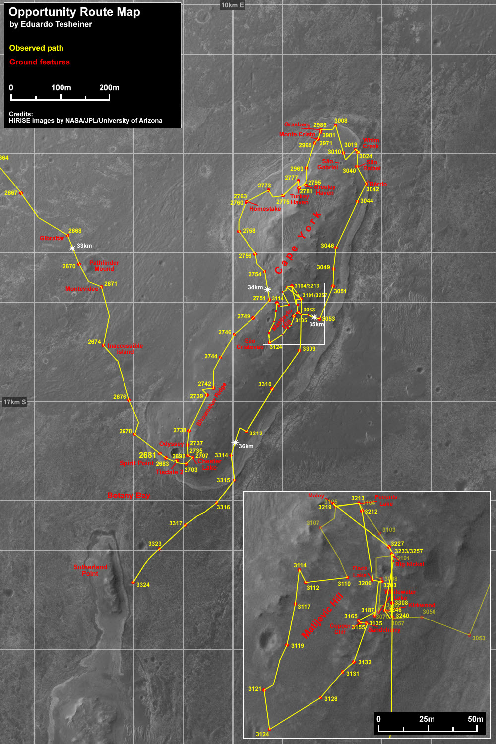
Opportunity route map
This route map, produced by Eduardo Tesheiner, of Unmanned Space Flight.com (UMSF) shows Opportunity's travels around Cape York and through its last drive of May 2013. Tesheiner creates his route maps, which are regularly featured in the MER Update, from images taken by cameras onboard the Mars Reconnaissance Orbiter.NASA / JPL / UA / E. Tesheiner
Nevertheless, they didn't wait to send commands to the rover to put her back under ground control. The first commands sent on April 30th never got to Opportunity because of an operational error. So the MER ops team uplinked the commands again and received confirmation from Mars May 1st that Opportunity was back online and working, carrying out the sequence of commands sent. There wasn't a sol to waste.
Opportunity spent much of the first week of May preparing to dig into Esperance. On Sol 3296 (May 2, 2013), the rover successfully completed the smallest turn in her history, of around 0.5 degrees, to get into a better position to use her rock abrasion tool (RAT). But a dust storm was whipping up nearby and threatening the completion of the Esperance analysis. "Dust can kill a rover and so storms are always a concern," said Nelson.
The concern this time was short-lived. Within a few sols, the storm quickly passed "well to the west" of Opportunity, according to MSSS' Mars weather report for April 29-May 5, 2013. But "elevated levels of atmospheric dust are expected over the rover site in the coming week as suspended residual particulates in the atmosphere are transported eastward by the southern tropical circulation," the report noted.
Darkened skies weren't about to stop this rover. On Sol 3301 (May 7, 2013), Opportunity showed her MER mettle and began to RAT into Esperance to uncover its secrets. Later that same sol, the rover recorded an atmospheric opacity or tau of 1.53 at her site, meaning it was really, really hazy, with visibility and sunlight was significantly reduced at Endeavour.
As the second week of May began, Sol 3302 (May 8, 2013), the opacity thinned a bit and the rover recorded a decreased tau of 1.45, but the skies remained noticeably hazy "due to proximity to the dust storm track over eastern Valles Marineris," according the MSSS weekly weather report.
Opportunity was certainly feeling the effects, as her solar array energy dropped from the 400s to 385 watt-hours with a tau measurement of 1.45. As important as the dust overhead is, so too is the rover's dust factor, which was at 0.584, meaning the rover was able to utilize less than half the sunlight hitting its arrays, but that number was likely going to get worse. Still, all Opportunity's systems were "nominal" or operating normally.
The robot field geologist pressed on. After taking pictures of the RAT hole in Esperance, Opportunity finished her analysis of the target with a full overnight APXS integration of the hole on Sol 3305 (May 11, 2013).
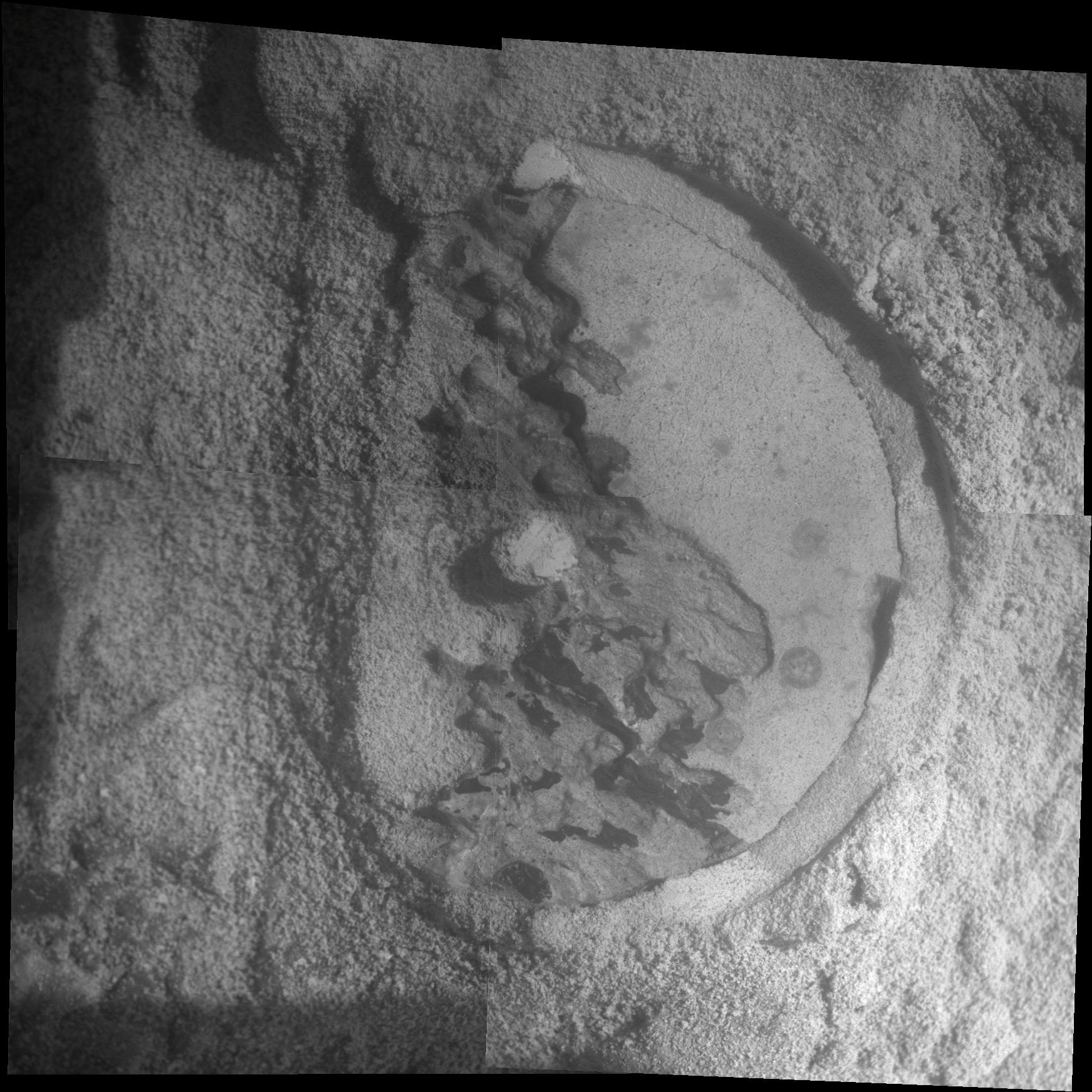
Esperance up close
Opportunity took four pictures of a freshly "RAT-ed" Esperance with her microscopic imager (MI) which then were merged into this mosaic. The component images were taken on the rover's Sol 3305 (May 11, 2013). The area shown is about 2.4 inches (6 centimeters) across. The APXS analysis of this target led the science team to conclude Esperance is different than any other rock units Opportunity has seen, and is composed of the clay minerals the MER tam came looking for on Matijevic Hill.NASA / JPL-Caltech / Cornell / USGS
Meanwhile, the day of Opportunity's departure was coming up fast. The MER ops team charted a route to Solander Point that is about 2.2 kilometers (1.4 miles) and mission engineers at JPL set the week of May 12th as the departure timeframe. The team, the rover, and her drivers were ready. "We're going south for the winter," said Lever. "Of course, south doesn't mean anything to us technically here. It just happens to be that the location we're trying to get to is south of us," he clarified.
Daily sunshine for Opportunity will reach winter minimum in February 2014. The MER team wants to be on a favorable slope in August.
The team members have actually already chosen a slope, from orbital images, that would put the rover in at least a 15-degree tilt. That northerly tilt would serve to increase output from the rover's solar panels during southern-hemisphere winter.
But the hoped-for objective is for Opportunity to work through and rove at least a little during its sixth Martian winter. That means finding an area where there are a number of choice slopes that would allow the rover to park at an angle of 15 degrees or greater, as well as offer intriguing science targets in close proximity for the robot field geologist to study. "Solander Point gives us that tilt and may allow us to move around quite a bit for winter science observations," said Lever.
On Sol 3308 (May 14, 2013), the MER, with 35.65 kilometers (22.15 miles) on her odometer and around 430 watt-hours of power, began her "winter sprint" to Solander Point with a brisk warm-up drive of 24.9 meters (81.7 feet). And then, during her second rove south, Opportunity logged 80.25 meters (263.29 feet), bringing its total odometry since landing on Mars, in January 2004, to 35.760 kilometers (22.220 statute miles).
That drive set a new NASA rover record, passing the 35.744-kilometer (22.210-statute mile) distance record established by Apollo 17 astronauts Eugene Cernan and Harrison Schmitt in the Lunar Roving Vehicle they cruised around the Moon for three days in December 1972.
The international record for driving distance on another world is still held by the Soviet Union's remote-controlled Lunokhod 2 rover, which traveled 37 kilometers (23 miles) on the surface of Earth's moon in 1973. But that record likely won't last much longer. "I expect we'll break Lunokhod 2's record and take the 'gold' later this summer, before we reach Solander Point," said Nelson.
The very next day on Earth, on May 17th, NASA-JPL announced that Opportunity's examination of Esperance confirmed the MER scientists' suspicions: the rock's composition was unlike any other the rover has investigated during nine years on Mars - higher in aluminum and silica, lower in calcium and iron. Moreover, it had been "intensely altered by water," as Squyres put it.
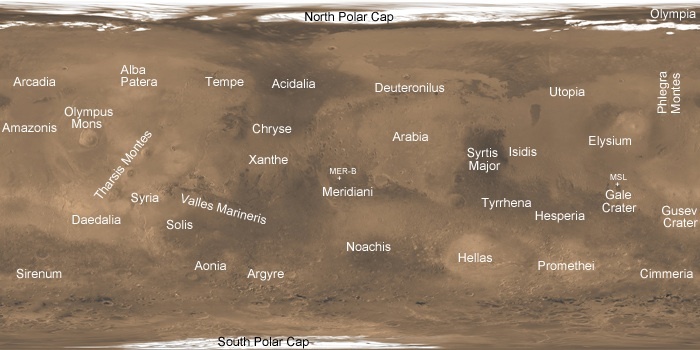
Malin's Mars map
The team at Malin Space Science Systems (MSSS) created this map that shows various locations on Mars frequently cited during the dust storms that can wreak havoc. MSSS personnel processed the images and wrote the caption information.NASA / JPL-Caltech / MSSS
"What's so special about Esperance is that there was enough water not only for reactions that produced clay minerals, but also enough to flush out ions set loose by those reactions, so that Opportunity can clearly see the alteration," said Scott McLennan of the State University of New York, Stony Brook, a long-term planner for Opportunity's science team.
Clays typically form in wet environments that are not harshly acidic. For years, Opportunity had been finding evidence for ancient wet environments that were very acidic. Matijevic Hill changed that. Esperance turned out to be the clay the MER scientists had gone to Matijevic Hill to find, and the rover's best evidence to date of a wet ancient environment, possibly favorable for life.
"There appears to have been extensive, but weak, alteration of Whitewater Lake, but intense alteration of Esperance along fractures that provided conduits for fluid flow," Squyres said. "Water that moved through fractures during this rock's history would have provided more favorable conditions for biology than any other wet environment recorded in rocks Opportunity has seen."
Meanwhile, as Opportunity roved on, the dust storm moved eastward and south of Hellas Basin and "gradually dissipated," according to MSSS' Mars weather report for the week of May 13th-19th. "In the southern tropics, skies above the Opportunity rover site in Meridiani," the report noted, were "still murky, but they were beginning to slowly clear."
"The dust storm did cause us some concern as we saw the atmospheric opacity (tau) increase to the neighborhood of 1.5 for several sols, but the storm did not become as serious as we thought it might," said Nelson. "Nevertheless, I don't think our concern was misplaced."
Indeed, it was assumed way back at the beginning of this mission that dust would be the most likely Martian threat to take out the MERs. But something this mission team has learned well over the years is that as Mars giveth, it also taketh away. As NASA was announcing the latest science finds from Matijevic Hill, Mars threw the team "another curveball," as Lever defined it. This time, it was a welcomed curveball.
While the skies continued to clear, a series of small dust-gusters riding the coattails of the storm blew by Opportunity between Sols 3311 and 3315 (May 17 and 21, 2013) and lightly "dusted" her solar arrays, enabling her to increase her solar power. "It gave us about another 100 watt hours," said Nelson.
With her newfound power, Opportunity, still in the Cape York segment of Endeavour Crater, stepped up her driving game. After putting 95.62 meters (313.71 feet) on her rocker bogie on Sol 3310 (May 16, 2013), the rover added another 96.30 meters (315.94 feet) two sols later, and then kept on truckin' from the third week of May into the fourth. The robot field geologist drove for 75.41 meters (247.41 feet) on Sol 3314 (May 20, 2013); 46.90 meters (153.87 feet) on Sol 3315 (May 21, 2013).
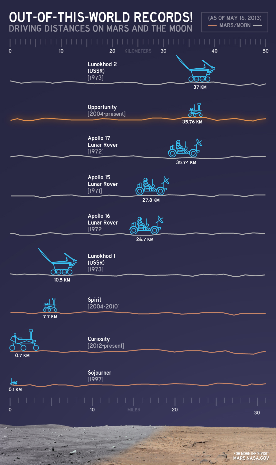
Rover records as of May 2013
This chart illustrates comparisons among the distances driven by various wheeled vehicles on the surface of Earth's moon and Mars. Of the vehicles shown, the NASA Mars rovers Opportunity and Curiosity, both of which were built and are being managed by JPL, are still active. The totals for those two Mars rovers are distances driven as of May 15, 2013.NASA/JPL-Caltech
As fourth week of the month got underway, Opportunity drove 61.78 meters (202.69 feet) on Sol 3316 (May 22, 2013) to finally clear Cape York proper. She then continued on, driving along the Bench on the inward side of Cape York for 83.91 meters (275.29 feet) on Sol 3317 (May 23, 2013). "We stopped right on the southeastern side of the Bench, and took some images, because we're interested in its geological relationship to the rest of the surfaces and rocks that we're seeing," said Arvidson.
Most of the MER scientists now believe that the Bench, the smooth apron that surrounds Cape York, is a "really, really old sedimentary deposit" that's on the Noachian ancient rim material that is Cape York (which, remember, is part of the Burns Formation that overlies the Bench forming materials). "It's a 'bench,' because it's a little bit more cemented, and so it's resistant to wind erosion," Arvidson informed. "It forms this kind of bathtub ring around the rim segments."
Opportunity was producing 541 watt-hours of power as the fourth week of May took hold. The tau was steadily dropping, measured at 0.9, and MSSS reported "clearing afternoon skies" over Endeavour in its weather report for May 20th-26th. But the rover's solar array dust factor tenaciously lingered around 0.65.
After a quick photo-reconnaissance of the Bench, Opportunity headed out onto Botany Bay, to the southeast of a little crater named Venera, after the Soviet spacecraft that went to Venus. [The team is keeping to the ships-of-discovery naming theme for craters.] "Venera, which is a relatively small crater, impacts into the Burns Formation, which is what's covering Botany Bay," Arvidson said.
Although the MER is on what Arvidson dubbed the "rapid transit route," as in the straightest path that gets the rover to her winter destination quickly, the engineers, who charted the route, built in a slight diversion from a truly straight path to go by Nobby's Head. "We want to map that area, to see if there are any good winter slopes in case we need a bail out," explained Stroupe.
"The rapid transit route is basically the engineering route, and it's very close to what Tim Parker and Matt Golombek [both of JPL] have been arguing as the red route," clarified Arvidson. [See Mars Exploration Rovers Update: Opportunity Begins Wrapping Science on Matijevic Hill, Sols 3209 - 3235] "The rapid transit route and the red route are sort of merging together," he said. The MER scientists certainly weren't complaining. Nobby's Head is, after all, more Noachian outcrop and there was even talk of doing some APXS there.
The skies over Endeavour continued to clear as May wound down. "The tau is now down to 0.8, which is not too far off where it was before the dust storm," noted Nelson. Clearing skies, the numerous little "dustings," the rover's fairly robust power levels, and all the good long drives she had put in during the last two weeks of the month, had given the MER team a few sols worth of margin.
"The dust cleanings we've gotten have actually taken some of the edge off some of the concerns about this winter," said Lever. "Even if we were to maintain the current dust factor [around 0.65], Opportunity still might be a little bit better off than last winter."
Believe it or not, there is a possibility Opportunity could get cleaner as she roves through Botany Bay. "It's very clear from the orbital imagery that the winds have been blowing the dust off of this surface, because you can see a lot of clean outcrop," said Lever. "Engineers are always hopeful, but the science [team] thinks that there's at least some evidence that that could be a good cleaning area."
"Botany Bay is probably a wind gap between the Solander Point and Cape York rim segments, and winds coming out of the crater have scoured the surface and produced a rocky plains," Arvidson elaborated. Time, as always, will tell.
The best thing of all though is the rover doesn't have to have any more dustings. "It would be exciting if Botany Bay turned out to give Opportunity some more cleaning, but at this point we don't need it," Lever confirmed. "We have a plan, we're executing that plan, and so far so good."
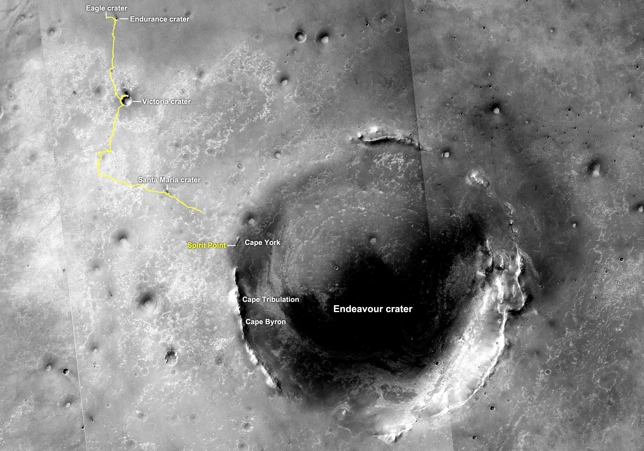
From Eagle to Endeavour
This image of Endeavour Crater was taken by the Malin Space Science Systems' Context Camera onboard MRO. The yellow line on this map shows the route Opportunity took from Eagle Crater, where the robot field geologist landed in January 2004 (at the upper left end) to a point about 3.5 kilometers (2.2 miles) away from the rim of Endeavour Crater. The rover pulled up to Spirit Point on Aug. 9, 2011, after nearly three years of roving from Victoria Crater. Until the middle of May 2013, the robot field geologist worked in the Cape York area. On May 14th, the rover roved on, heading south on a 2.1-kilometer trek to Solander Point, for its next Martian winter. From Cape York, Solander Point is about two-thirds of the way to Cape Tribulation.NASA /JPL-Caltech / MSSS
Throughout the last week of May, Opportunity was raring to drive and so was the team. "We're we're trying to do is drive as much as possible as power and Flash allow," said Arvidson.
"To extend our drives, we have been doing some auto-nav at the end, so we will drive blind about as far as we can see, and then we will turn on auto-nav and try to drive a little further," said Nelson. "Now auto-nav takes a lot of images, does computations, figures out hazard maps, and so forth. All of those are turned into data products and saved, because if we have something weird happen, we'd like to be able to reconstruct what the rover did. Well, all those things take up a lot of room, and suddenly we filled up our Flash," he explained.
"We accumulated not only auto nav, but we also wanted to do 360 NavCams because we were driving these landforms that we'll never come back by, and then there was some pan cam imaging of the Bench after we were leaving Cape York," added Arvidson. It's a lot for a memory system that holds just under 1500 megabits.
Over the long American Memorial Day weekend, Opportunity cleared a lot of her stored data out of Flash. "We average probably between 60 and 80 megabits per sol as far as what we can download," added Nelson. "Some days it's a lot better. Some days not so much." In the week following the holiday, the rover downlinked even more data, giving the rover plenty of memory to rove on without concern.
On May 29th, the rover's Sol 3322, Opportunity came upon what the science team is calling a Ghost Contact. "It's just exterior of the Bench and seems to just be some Burns Formation layers that lap up against the Bench, and have been eroded, so it is a ghost of a bench," explained Arvidson.
Opportunity proceeded to drive out the month, putting 75.33 meters (247.14 feet) on her rocker bogie on Sol 3323, and another 80.33 meters (263.55 feet) on Sol 3324 (May 31, 2013). With those drives, the rover entered "the apron area between Sutherland Point and Nobby's Head," said Arvidson.
From there, the rover will drive closer to the circular hill during the first week in June to conduct her photo campaign. "The northern side of Nobby's Head is the best bet for slopes that we need to go back and hang out there for the winter," Arvidson added.
Once that imaging is done, the plan is to have Opportunity put her pedal to the metal again and get to Solander as soon as possible. "The main idea is to preserve the 3 sols of margin we have now by doing stereo imaging of the northern side of Nobby's Head and keep going south," said Arvidson.
"We're doing our best to knock off some more records," smiled Nelson. "With the return of the tau and with the cleaning events that we've had, we appear to have plenty of energy, which means that we'll be able to drive for long periods of time, which in turn means that we can rack up some pretty good distances," he said.
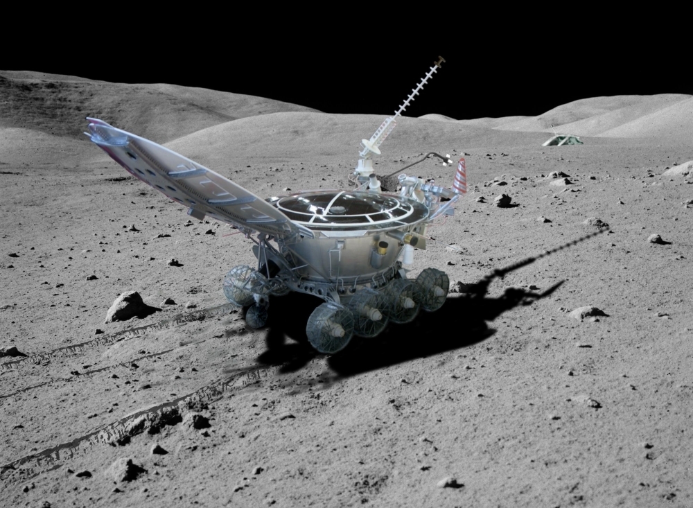
Lunokhod 2
The Mars Exploration Rovers mission has one more rover distance record to best, that of Lunokhod 2, the second of two unmanned Soviet rovers sent to the Moon in 1973. The robotic rover traveled 37 kilometers (22.99 miles) on the surface of Earth's Moon and has held the rover driving distance record ever since. Opportunity, however, is closing in fast to take the 'gold.' Lunokhod means "moonwalker" in Russian.At months end, Opportunity had 625.33 meters (0.39 of a mile) to best the Lunokhod 2 mark. In terms of energy, she was producing upwards of 540 watt-hours and doing better if only slightly than the last Martian winter. "We're a little bit above previous years, so that's good, although not significantly so," informed Callas. "There's enough scatter in the data that we're kind of where we would expect to be, but maybe just a little bit better."
Despite Opportunity's textbook changing, engineering achievement in overtaking the Apollo 17 record in May, there's no time for the MER team members to look at their laurels much less rest on them. This mission just keeps on going and going. "I have to admit that I'm somewhat amazed at this rover's longevity," reflected Nelson. "Knowing how hard we sometimes drive this thing, she has performed beautifully."
Actually, Opportunity logged an impressive total of 772.67 meters (0.48 of a mile) for the two weeks it drove in May.
Nearly 10 years into the mission that was originally slated for 90 days, no one on the team is bored yet. "In some ways, it's more exciting because of the fact that the number of years, the amount of dust, and things like that have created a bigger challenge or made the survival more satisfying," offered Lever. "Right now, we're cautiously optimistic that we'll have another good winter of science," he added. "But, like always, we have our fingers crossed."
* There are two prominently cited distances for the Apollo 17 Lunar Rover Vehicle (LRV) as it was called. Opportunity has surpassed both the official and unofficial Apollo records. The official NASA distance, recorded as 33.744 kilometers, is taken from an agency document entitled, Apollo by the Numbers, by Richard W. Orloff [200-NASA SP-2004029]. The unofficial distance, 35.89 km, is found in Wikipedia and other places. For the record, Nelson said: "We took longest distance published in NASA publication." In any case, four sols after it beat the official record, on May 20th, 2013, Opportunity surpassed the unofficial record, noted Nelson.
Protect Our Shared Future
You help us defend humanity and prevent asteroid impacts. Donate now to become a Planetary Defender!
Donate