
 Explore Worlds
 Find Life
 Defend Earth


Mars Exploration Rovers Update: As Mars Orbits Nearer to Earth, Spirit and Opportunity Rove Onward into New Territories

Written by
A.J.S. Rayl
Contributing Editor, The Planetary Society
October 27, 2005
 Mars is particularly noticeable in the night sky these days. It burnslike a large, firey red-yellow orb, in the east if you're around the partof the globe that contains The Planetary Society. Wherever you are, you can'tmiss it. From now through early November, the Sky & Telescope astronomerssay, anyone can see it "no matter how little you know about the stars orhow badly light-polluted your sky may be."
Here's a suggestion: Instead of taking in another hour of intense news tonight, go outside and take in Mars. Consider that amidst all the madness in the world today something remarkable is also going on: two little American rover robots are tooling around up there. No robots have ever roamed the surface of another planet for so long, and been so successful at digging up the details of a world that represents, on one level or another, a more hopeful future -- for space exploration, and for the collective conscience of humankind.
Credit: NASA and the Hubble Heritage Team (STScI/AURA)The Mars Exploration Rovers science team witnessed a bit of an expansion down here on Earth this month, while up on the Red Planet Spirit and Opportunity continued roving along. As Halloween nears, the twin robot geologists have put in another solid month's worth of work, overcoming every occasional "hiccup." At this point, as Mars' orbit brings it as close to Earth as it will get until the summer of 2018, both Spirit and Opportunity are moving into new territories at their respective inspection sites.
Spirit is heading down Husband Hill, a whole new experience for the rover and the drivers. On the other side of the planet, Opportunity is moving along the west side of Erebus Crater, toward some outcrop rocks and a "particularly tasty-looking promontory," as lead rover scientist Steve Squyres has described it. Dubbed Payson, it is probably the biggest outcrop anywhere along the Mogollon Rim, according to Squyres, and is luring the science term on a journey that has already brought on some driver "whoas."
As Spirit begins her hike down Husband Hill and Opportunity moves around the rim of Erebus Crater, the team scientists and engineers have been spending quality considering some of the most interesting routes either rover has confronted in a long time. So far, no challenge has been too great, and the rovers just keep going, and going, and going.
Both Spirit and Opportunity are in good health, and producing ample watts of power. Spirit is putting out "in the high 700s" watt hours," and Opportunity is almost as energetic, putting out watt hours "in the high 600s," reported Joy Crisp, MER project scientists at the Jet Propulsion Laboratory, where the rovers were designed and built. Since landing, Spirit has logged 5 kilometers (3.1 miles), while Opportunity has tracked 6.2 kilometers (3.8 miles), far beyond the 600 meters (about 1/3 of a mile) guaranteed in their "warranties."
The dust levels, however, have gone up a bit at Meridiani Planum, Crisp said in an interview yesterday. "There have been some sightings of local to regional scale dust storm activity on Mars by amateur astronomers and by the Mars Orbiter Camera on the Mars Global Surveyor (MGS) orbiter," she added. The team does not expect it to become a global dust storm, because this is not the time of year for global dust storms. But it will mean power levels will go down.
"Opportunity is seeing some effect now and the prediction is that Spirit may see some effect when the dust storms spread around as they do." While this kind of dust storm will basically deposits dust on the solar arrays, other strong gusts and dust devils blow it off, weather events both rovers have experienced repeatedly. So there's no real concern that the solar arrays will get muddled by dust so as to not function. "At this point, with the experience that we've had, we don't really have a serious concern about it," Crisp said. "It's the level we've had and lived with all along. The fact that we're out of major dust storm season also gives us confidence."
Spirit from Gusev Crater
During the last four weeks, Spirit has continued her investigations at the summit of Husband Hill. The rover finished up a thorough study of Cliffhanger, a drift target right at the top of Tennessee Valley toward the end of September. She scuffed the drift with her wheels and conducted did a good set of instrument measurements with the Mössbauer spectrometer and the alpha particle x-ray spectrometer (APXS), and images with microscopic imager (MI), both before and after the scuff, just like she did way back when on a drift called Serpent that she encountered out on the plains.
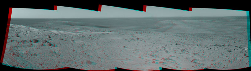 NavCam panorama from Husband Hill summit
The first explorer ever to scale a summit on another planet, Spirit has begun a long trek downward from the top of Husband Hill to new destinations. As shown in this 180-degree panorama from east of the summit, the rover's earlier tracks are no longer visible. They are off to the west (to the left in this view). Spirit's next destination is Haskin Ridge, straight ahead along the edge of the steep cliff on the right side of this panorama. The scene above is a mosaic of images that Spirit took with the navigation camera on Sol 635 (Oct. 16, 2005) at Gusev Crater.Credit: NASA / JPL / Caltech
As September came to a close, Spirit completed the long-baseline stereo imaging of Tennessee Valley for a 360-degree color mosaic, and performed remote sensing of other targets of interest, then roved into October by climbing to the true summit. "It took us a little time to get to the tip-top of the true summit," Crisp explained. Once there, the science team instructed the rover to move in on the clean face of the rock outcrop called Hillary, in order to find a good position to study it up close. Spirit's first attempt to approach Hillary ended, however, when a rock got caught up under the rover's left front wheel, causing the rover drivers to question whether or not Spirit was stable.
The drivers commanded a set of wheel wiggles. "We were doing the little wheel wiggles to get into a position where the rover was properly settled down and able to safely put the arm out and take measurements on Hillary," Crisp elaborated. After looking at several images, rover meshes, and Rover Sequencing and Visualization Program (RSVP) simulations after the wheel wiggles, the team was able to determine that Spirit was in a more stable area, and ready to work.
Rover meshes are three-dimensional terrain maps that are created by rover team members by "gluing" together multiple pieces of data from the hazard-avoidance cameras (for the up-close images), navigation cameras (for middle distance images), and panoramic cameras (PanCams) (for distance images) to produce a view of the Martian landscape suitable for multiple tactical purposes. The rover planners use the RSVP software tool to plan sequences of commands for driving and robotic arm work. It can simulate a sequence, for example, showing a model of the rover superimposed on actual images of the Martian terrain.
Spirit began a conservative robotic-arm campaign on Hillary, with the Mössbauer spectrometer, then alpha particle X-ray spectrometer (APXS). "Hillary turned out to be a lot like Jibsheet, even though it's quite a ways away from Jibsheet, and the orientation of the layers in Hillary was quite different," said Crisp. Jibsheet was part of the batch of targets investigated last May, along with Methuselah and other targets in a large stretch of layered outcrop at a lower elevation. "It was interesting to find this rock in its texture, chemistry and mineralogy looks like Jibsheet, one that matches something we've seen before, because we are always finding new kinds of rocks. "We don't know what that means," said Crisp. "But it's a clue." It may have been that the rocks were dispersed by the impact of an asteroid or something like it. But, noted Crisp, "there are other possibilities."
The science team spent some time this month considering Spirit's next major destination and the route by which to get to it. The scientists knew they wanted the rover to descend the south side of Husband Hill, heading toward the south basin. Team members had already decided they eventually want to head toward a target dubbed Home Plate down in the basin, but it took some thought to decide how, exactly, the rover is going to get there. Husband Hill is very steep in places on this side, and the orbital images show a lot of "tasty geology" along the way, as Squyres put it, but some of it is in foreboding places.
On Sol 634 (Oct. 15), Spirit completed work on Hillary with the microscopic imager, then stowed her robotic arm, and bumped back about 2 meters (7 feet) from the outcrop to some remote imaging. The rover used her miniature thermal emission spectrometer (mini-TES) and panoramic camera (PanCam) to check out specific targets on Hillary. The next sol Spirit drove 47 meters (154 feet) east from the summit. Elevation maps produced from the PanCam imagery taken at and near the summit of Husband Hill showed this was a good location for a safe traverse down Husband Hill -- with vehicle tilts under about 20 degrees, and it was the one scientists and engineers agreed upon. The team previously defined a maximum allowable percentage of slip to be 40 degrees, and if the computed slippage exceeds that maximum, the rover will stop.
The planned traverse paths for Spirit run across ridge lines east of the summit, which the MER team has dubbed Haskin Upper Ridge and Haskin East Ridge. Even though the general route has been worked out, the driving plan is always fluid. "As we go we have to keep reassessing the slopes and terrain to make sure the path is still good," Crisp pointed out. "We can't do that just using the orbital data. We have to keep looking with the rover cameras and assessing it close-up. There are some tricky, steep areas, and the rover could potentially slide into an area where we would have trouble getting out."
For anyone who's hiked to any serious elevation, going down if often more intimidating than going up. "But the rover doesn't have a brain to register fright, although it does have gyroscopes that go 'Wait a minute, I'm tilting too much,'" said Crisp. "That's why we're really glad these rovers aren't too smart. They might not want to go where we want them to go," she chuckled. Actually, it's easier for Spirit to go down like this than it was, she noted, going up Husband Hill. "Remember when we went into Endurance -- we worried if we would ever be able to get out. Now we don't have that problem. Still, we don't want the rover to tilt too much.
In recent days, Spirit went into a period of restricted sols, which "conveniently occurred," said Crisp, "at the same time we spotted an interesting patch of light-toned rock." Since the rover can't drive everyday when it's on restricted sols, the timing of finding an interesting rock was perfect. Restricted sols -- which are initiated when Mars and Earth aren't lined up in a way that downloads and uploads can take place in a fast enough timeframe for seamless communication -- are commonplace these days for both rovers.
Currently, Spirit is examining this light-toned rock, the team now calls Kansas, with the spectrometers and the MI. She will also be brushing Kansas with the rock abrasion tool (RAT) and re-imaging it to get a look inside. In coming days and weeks, the rover is scheduled to move on from Kansas and continue her trek along the ridge lines and down Husband Hill.
Opportunity from Meridiani Planum
 Opportunity panorama of Erebus Crater
This image taken by Opportunity is a portion of a mosaic acquired by the panoramic camera (PanCam). The picture highlights the light-toned outcrop on the rim of Erebus Crater and large, dark, wind-deposited drifts that have filled the center of the crater. The rover took this image on Sol 608 (Oct. 9, 2005). Currently, the rover is driving west, avoiding the large drifts and crossing the low ripples and outcrop to the right. After traversing to the north of the large drift on the horizon (near the center of the image), Opportunity will drive south to the western rim of the crater.Credit: NASA / JPL / Caltech / Cornell
After some drama with a puzzling and sudden reboot at the end of August, Opportunity got back in the saddle in September and toward the end of the month was getting in some fine cruising, days of solid drives that put her near the northern rim of Erebus Crater. Suddenly, when she was in the middle of studying South Shetland -- a rock target that Squyres defined as "a really beautiful exposure of bedrock" in the last MER Update -- the rover's computer rebooted again, and Opportunity once again went into safe-mode.
This glitch caused the team to miss two Odyssey passes, meaning the rover was unable to upload her information to the orbiter and clear her memory. The evening pass was missed because the reboot occurred during the Odyssey pass. The morning pass was missed because safe mode enforces the DeepSleep mode.
Real-time commands were sent on Sol 597 (Sep. 28) in order to access the state of the vehicle. Opportunity reports conveyed she was healthy and the team regained control of the vehicle. The reboot appears to be the kind of reboot the rover experienced in August, Crisp said, though engineers are still not exactly sure what caused either reboot. The engineers are thinking it's software related, caused perhaps by a 'bug' that allows a window of vulnerability in the process of lifting memory write protects and replacing them. The bug allows a 51-microsecond window where another write request can interrupt the first request. When the writes collide, the software protects itself and the vehicle by terminating activities.
In any case, it just may be a software glitch that the team will have to contend with now and again on both Opportunity and Spirit, Crisp said. "We're working on it and diagnosing it and the current thinking is that these are just sporadic hiccups that we can live with," she expounded. "It's not mission-ending and we're closer to understand why they're happening. But we do have to -- every time it happens -- be careful when we come back to regular operations."
Opportunity continued on, completing work on South Shetland, and taking a Pancam panorama that captured most of Erebus at the highest resolution possible. Then, the rover moved closer to the rim of Erebus Crater, where the science team members confirmed that the good outcrops are on the southeastern rim at an area they designated as the Vermillion Cliffs, and on the western rim, they dubbed the Mogollon Rim. They had already decided not to drive inside Erebus. "There wasn't a place for us to go into the crater safely, and inside there were a lot of large sand dunes," Crisp said.
While the Vermillion Cliffs look easier to get to, they aren't as high. And although the Mogollon Rim exposes more rock, it looks harder to get to - but it featured the "particularly tasty-looking promontory," dubbed Payson, which is probably the biggest outcrop anywhere along the rim, according to Squyres. It would be something of a challenge to get there, but following a debate over which way to go, the team's decision came with relative swiftness. Opportunity headed west, driving counterclockwise around Erebus Crater.
Opportunity rolled into October operating normally. On Sol 601 (Oct. 2), the rover drove 34 meters (112 feet), and on Sol 603, the team planned a 45-meter (148-foot) drive. However, after the first 5-meter (16-foot) segment, the onboard slip check reported a 44.5 percent slip. Because that exceeded the maximum allowable slip limit, the rover stopped. (The onboard slip check uses visual odometry to compare nearby features and determine the actual distance traveled. Software computes the amount of slip based on the difference between the actual distance traveled versus commanded wheel rotations.) On Sol 605 (Oct. 6) the rover drove 5.3 meters (17 feet) back to outcrop material where she could get amore solid "footing." After that, Opportunity began making excellent progress.
By mid-month, the rover was taken off restricted sols, and as a result traveled 101.65 meters (333 feet) in the following four sols. While Opportunity is generally heading westward around the crater, she had to travel northward a bit on Sol 618 (Oct. 19) to avoid some larger ripples to the west. As the rover has been making her way west around the rim of Erebus Crater, the science team has been seeing some changes in the rocks, Crisp said. "We're seeing the blueberries getting smaller and in some layers they appear to be absent. We still need to look with the MI to confirm if they are absent, but from some of the HazCam images, it looks like some of the layers may be free of the concretions." They are each speculating on what that means -- and whether this means the rover is roving into an area of younger rocks that never got soaked by water in the same way that formed the concretions. "We don't know, yet, " said Crisp.
In coming weeks, Opportunity will continue her journey around the western side of Erebus to the Mogollon Rim. "From orbit, we see a fairly large patch of rock and a little bit of a cliff exposure in Erebus, which is the Mogollon Rim," Crisp elaborated. "We hope when we get around to there, we'll be able to maneuver our way over to that patch of rock and find out what it looks like." The long-range plan, at least for now, is for Opportunity to rove down to Victoria Crater, which lies a couple kilometers further to the south.
In other MER news
At a time when just about every aspect of the agency is in a state of flux or transition, when so many science programs, projects, and even divisions have been cut to the bone or cut altogether NASA is funding new research into the reams and reams of data from the resilient rovers. "Spirit and Opportunity have exceeded all expectations for their longevity on Mars, and both rovers are in good position to continue providing even more great science. Because of this, we want to add to the rover team that collectively chooses how to use the rover's science instruments each day," Michael Meyer, lead scientist for the Mars Exploration Program, stated in an official announcement last week.
NASA tapped eight outside investigators to join the MER science team, as part of the Mars Exploration Rover Participating Scientist Program, pushing the total number of MER scientists to somewhere near 160 people. The new participating scientists -- who were chosen by proposals judged on the basis of merit, relevance, and cost-effectiveness -- become official members of the Mars Exploration Rovers science team, according to Meyer. Among them is Oded Aharonson, assistant professor of planetary science at Caltech, who with his colleagues will be analyzing rover data to see if liquid water has ever altered them.
Liquid water, of course, remains the Holy Grail in NASA's Mars Exploration program, where the mantra is: 'Find the water.' While there is no liquid water on Mars now, Opportunity made global headlines more than a year and a half ago for finding geological evidence that liquid water pooled on the surface in a shallow, salty, perhaps, transient, sea on the floor of Meridiani Planum at some date or dates in the past.
And in other rover news, MER science team member John Grotzinger left the Massachusetts Institute of Technology (MIT) and has taken up the post of Fletcher Jones Professor of Geology at the California Institute of Technology (Caltech), putting him physically closer to the rovers' mission control at the Jet Propulsion Laboratory (JPL).
Protect Our Shared Future
You help us defend humanity and prevent asteroid impacts. Donate now to become a Planetary Defender!
Donate