
 Explore Worlds
 Find Life
 Defend Earth


Water and the Curiosity Landing Site Candidates

Written by
Ken Edgett
Senior Research Scientist, Malin Space Science Systems
May 28, 2009
NASA announced yesterday that the Mini Cooper-sized Mars Science Laboratory (MSL) rover—with its 2 meters-long (6.6 ft) robotic arm—is now named Curiosity.
Darn. I always have trouble spelling that word. I instinctively type "Curiousity," with a "u" and then get caught by the spell-checker!
MSL is scheduled to launch in the October–December 2011 timeframe. The exact launch period, either in October–November or November–December, will depend, at least in part, on when the Juno spacecraft (headed for Jupiter) gets off the ground during its launch period in August 2011. Both spacecraft are going on Atlas V's from the same launch pad, and it takes a certain number of days to get the next vehicle out to the pad and ready for flight.
Curiousity—nuts! Did it again!—Curiosity will land on Mars sometime in August–September 2012. It carries instruments designed for conducting ten science investigations to examine the geology, geochemistry, and environmental conditions at the rover's landing site.
Where Curiosity lands has been a matter of discussion for several years, as many of you know. There have been three workshops, thus far, for Mars scientists and other interested parties to discuss potential landing sites and narrow the list. As of November 2008, we are down to 4 sites—although, with the launch delay from 2009 to 2011, NASA is holding out the possibility that an exciting new site could emerge from the on-going analysis of Mars orbiter data. Meanwhile, we're down to 4 sites that, so far, look like places that the MSL Entry, Descent, and Landing (EDL) system can handle.
The sites are located at Mawrth Vallis, Eberswalde Crater, Holden Crater, and Gale Crater. Below is a figure and caption which describe where these sites are located; you can also read about the landing site selection process and the basic rationale for these sites in the 2009 Lunar and Planetary Science Conference (LPSC) abstract by Matt Golombek and colleagues: http://www.lpi.usra.edu/meetings/lpsc2009/pdf/1404.pdf.

Curiosity's 4 Candidate Landing Sites
The candidate MSL landing sites are shown in the above figures as ellipses of approximately 20 by 25 kilometers (12.4 by 15.5 miles) size. Each ellipse is placed approximately, as the exact location may change slightly as mission plans evolve. On the left is the Mawrth Vallis site, located on light-toned layered rock near 24.3°N, 19.0°W. At the center are the landing site candidates in Eberswalde Crater (near 24.1°S, 33.4°W) and southern Holden Crater (near 26.6°S, 35.0°W). On the right is the landing site candidate in northwestern Gale Crater (near 4.5°S, 222.7°W). The orange feature in Gale is a fan of sediment transported to the crater floor by a channel that cuts the crater's northwestern wall. Each figure is shown at the same scale and north is up. These are mosaics of Mars Global Surveyor (MGS) Mars Orbiter Camera (MOC) red wide angle images acquired during the May 1999 Geodesy Campaign. The data were map-projected and mosaiced by Malin Space Science Systems personnel.
Credit: NASA / JPL / MSSS
The MSL mission is broadly focused on the subject of "habitability" and placing constraints on whether Mars was habitable by "life as we know it" at some time in the past. From a geological perspective, this means that the conversation has shifted toward the topic of taphonomy—the decay, fossilization, and preservation of fossil evidence of formerly living organisms. (If you have access to the journal, Nature Geoscience, you can read more about this idea of thinking of MSL science in the context of taphonomy in an April 2009 piece by MSL Project Scientist John Grotzinger: "Beyond water on Mars").
Finding fossils on Mars—even microscopic ones—is a huge long-shot. Fossils are hard to find on Earth. Yet our home world has been teeming with life for billions of years. Indeed, most of Earth's rocks—including those formed of sediment deposited in streams, lakes, and oceans—do not have fossils in them.
What we can do with MSL is to try to decipher some of the record of ancient martian environments that are preserved in layered sedimentary rock. Getting a better sense of what Mars was like during its early history, and seeing whether there is any glimmer of hope that some sediments—which are now rock—might have been deposited in the types of environments where organic compounds or fossil evidence of organisms could have been preserved—those are the kinds of things some investigators hope to learn using MSL. The investigation will also look at whether—regardless of the environment in which ancient sediments were deposited—the rocks could have preserved such evidence over the long haul, or whether they have been badly altered by interaction with groundwater or other processes since that time.
So, indeed, MSL is not an astrobiology mission. It does not carry life detection experiments, and no one expects it to find evidence for life. Even MSL's Mars Hand Lens Imager (MAHLI), a camera that can resolve the coarsest grains of martian silt (~60 microns—0.0002 inches—in size), would not be able to see microorganisms unless they happened to have made a macroscopic feature, such as the mats formed by some microscopic organisms on Earth.
Dream on!
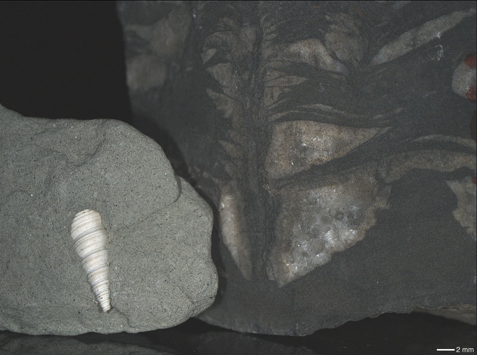
This is an image of fossils in Earth rocks as seen by the MSL MAHLI camera during calibration testing in September 2008. The rocks were illuminated by MAHLI's white light LEDs (Light-Emitting Diodes). On the left is an Eocene sandstone from San Diego, California, containing a fossil marine gastropod shell (Turritella uvasana). The rock on the right, collected by Co-Investigator Dawn Sumner (University of California, Davis), contains fossilized microbial mat remnants (the dark, almost black features in the image) encased in calcite from the Gamohaan Formation of South Africa. This rock is about 2.5 billion years old. The full-resolution image has a scale of about 34 microns (0.0001 inch) per pixel; the 2 millimeter scale bar equals 0.079 inch.
Credit: NASA / JPL / MSSS
So, how does one go about finding a place to send MSL that can be used to address the question, "was Mars once habitable?" or, "were there environments in which evidence for organisms could have been preserved?" Honestly, we don't know enough about Mars to know for sure where to go. We'll suffer this same problem if we mount a sample return mission to Mars in the coming decade or two: where is the one place to send your multi-billion-dollar spacecraft to find the thing you hope to find, but have no basis to know that it ever even existed? The geology of Mars is complex and its geologic record is only barely known to us at the present time.
So, like many other decisions one makes in life, we have to choose a landing site based on incomplete information. But—I'll tell you—we sure do have a lot of information. We've got more for MSL landing sites than we had for the Mars Exploration Rover (MER) sites, and certainly more than what we were dealing with a decade and a half ago when figuring out where to send Mars Pathfinder.
The four candidate MSL landing sites approach the problem by considering an investigation of very ancient, layered rocks that have a "water" story to tell. At three sites (Eberswalde, Holden, Gale), strong cases are made that the rocks to be examined by MSL are largely sedimentary, although one (Eberswalde) presents a better case for sedimentation than the other two. In the fourth case (Mawrth), there is not general agreement that the rocks are sedimentary, but near infrared spectral imaging by the Mars Express OMEGA and Mars Reconnaissance Orbiter (MRO) CRISM show that there are a variety of clay minerals present, and that these occur in specific layers. Whether the layered, clay-bearing rocks at Mawrth Vallis are altered volcanic ash, ancient regolith ("soil") horizons, or sedimentary rocks deposited in a lake, sea, or dry desert, remains to be determined. Likewise, while the case is strong that the feature to be examined at Eberswalde Crater—an ancient, fossilized river delta—consists of sedimentary rock, it is less obvious how much of the layered mound in Gale Crater or the light-toned, layered rocks of southern Holden are composed of sediments versus deposits of volcanic ash.

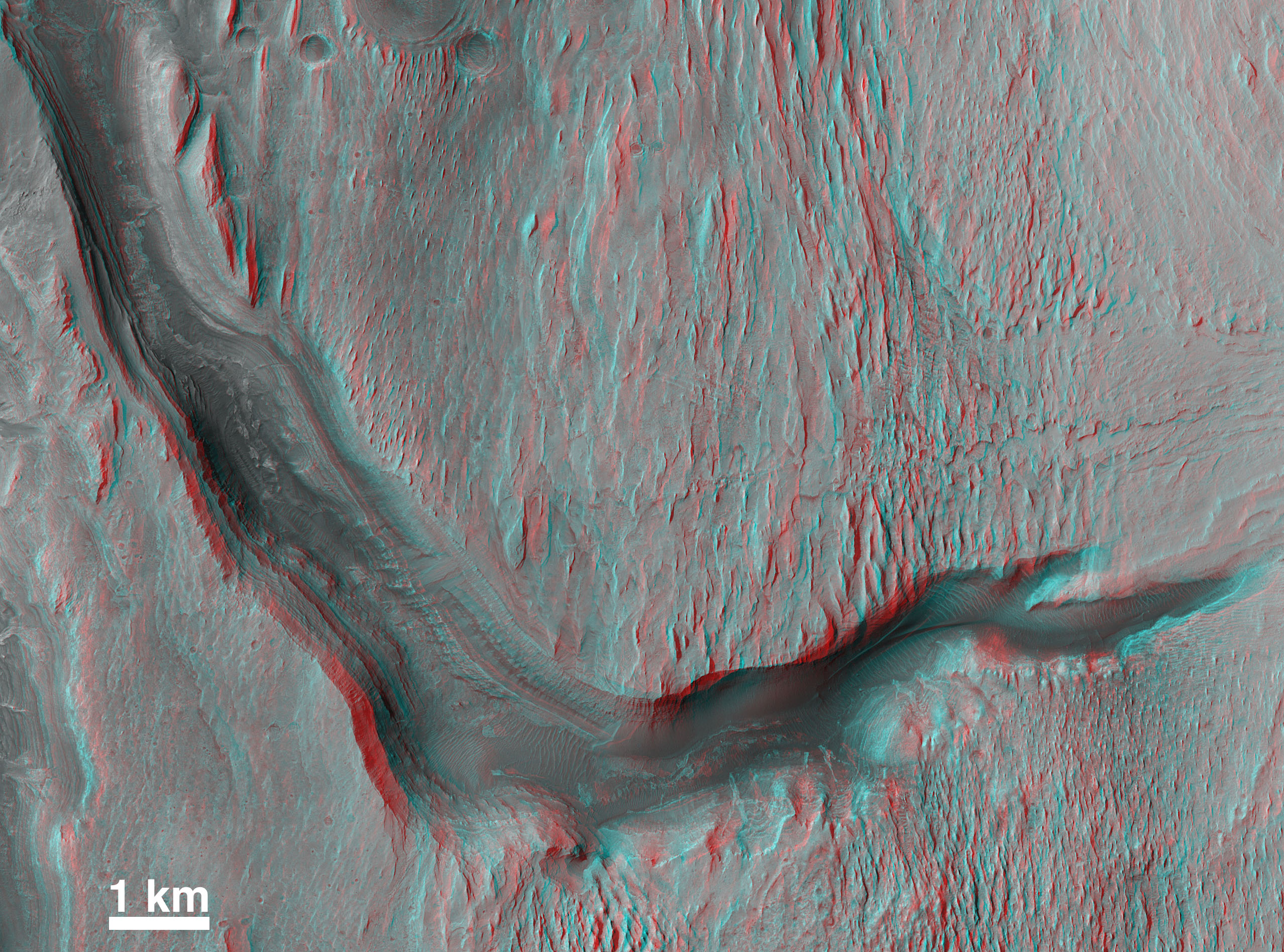
Fossil "River Delta" in Eberswalde
Discovered in 2002–2003 using the MGS MOC, the fossil "river delta" in Eberswalde Crater has drawn considerable attention as a place to investigate questions of whether early Mars was habitable. This stereo anaglyph (red left eye, blue right eye) view of the inverted channels of this ancient geologic feature was compiled by Malin Space Science Systems personnel using Mars Reconnaissance Orbiter (MRO) Context Camera (CTX) images P01_001336_1560_XI_24S033W and P01_001534_1559_XI_24S033W. The stereopair was acquired in November 2006.
Credit: NASA / JPL / MSSS
OMEGA and CRISM results show that all four candidate landing sites have rocks that contain clay minerals. Clay minerals commonly form when water causes weathering and alteration of other silicate (silica-oxygen bearing) minerals, and clays also have water in their structure. If these minerals dominate the rock (something we really can't exactly determine from the remote sensing observations), then some of them may be shales—shales are the most abundant type of sedimentary rock on Earth. On our planet, shales are made mostly of clay minerals and very small particles of quartz (we'd not expect to see much quartz in martian sediment, as this mineral isn't very common there). Shales—sedimentary rock formed from mud—are great places to preserve evidence of ancient life on Earth. You've probably heard of oil shales—lots of gooey organics in those—but good luck to all who hope to find such things on Mars. :-)
What is important about the MSL landing sites is not so much what minerals we can detect from orbit, but what will be the full range of minerals and the geologic history that can we determine when Curiosity is roaming around on the ground. There is only so much (or, I should say, there is so little) that we can learn from orbit (and only so much you can learn on the ground, for that matter, depending on what instruments you have).
If MSL were to land in Eberswalde Crater, it would land to the east of the delta feature that was first identified in MOC and THEMIS images. MSL would initially examine rocks in the landing ellipse, on the floor of Eberswalde, looking for evidence that the crater hosted a lake at the time the delta was created (and earlier). Then, MSL would be driven toward the delta. Eventually, it would get there and examine what is considered to be the "smoking gun" evidence that water (or a liquid of the physical properties of water) flowed persistently on ancient Mars and created sedimentary deposits that were later hardened to form rock. As at Mawrth Vallis, clay minerals have been detected in MRO CRISM observations of the Eberswalde site.
If MSL were to land at the candidate Mawrth Vallis landing site, the rover would not have to drive far, if at all, to find clay-bearing, layered rocks. The rover would investigate the nature of these rocks and the environmental conditions they record, and the science team would try to examine as many different layers as possible in the region.
If MSL were to land in southern Holden Crater, it would land on (and briefly examine) alluvium shed from the adjacent southern wall of the crater before being moved on, toward a group of light-toned, layered rock outcrops in the area where Uzboi Vallis enters Holden Crater. Some of these rocks, like the rocks in Eberswalde and at Mawrth, contain clay minerals, and studying these rocks is the main objective of a Holden MSL landing.
Finally, if MSL were to land at Gale Crater, it would land on or near a fan of debris brought into the crater by a channel that cuts its northwest wall. The rover team would briefly examine the fan sediment before heading southward to the giant mound of layered rock that dominates the northern half of the crater. This mound contains a stack of layers that is about 5 kilometers (3.1 miles) thick—the highest point on the mound is higher than the north rim of the crater, and it is about even with the south rim. As the layers in the mound lie nearly horizontal, the mound likely represents a remnant of materials that once extended all the way to the walls of the crater and, indeed, filled it. Spectra from the CRISM have shown that this mound has some layers that contain clay-bearing rocks, and some layers that have sulfate-bearing rocks. It is the only one of the 4 landing sites that we currently know has both clay-bearing and sulfate-bearing materials.
Each landing site is exciting in the context of water on Mars. People often ask me "how old are the rocks at the 4 candidate MSL landing sites?" I really can only answer this question in the context of water.
We don't have absolute dates for any rocks on Mars (although we do have dates for the martian meteorites—none of which, by the way, are sedimentary). We can count the number of craters on the rock outcrops, but that does not provide an estimate of the age of the rock, it only provides an estimate of how long the rock has been exposed at the surface and eroding (further, if the rock is relatively soft, small craters erode away faster than they do if the rock is hard, like on a lava flow).
So, how can we know that the rocks at each of the 4 MSL landing sites are extremely ancient, hopefully dating back to the earliest history of the planet? We look at the evidence that a fluid with the properties of liquid water did something to the rock. Granted, the presence of clay minerals at all 4 sites, plus sulfates at Gale, are mineralogical clues used by geochemists to suggest that water played a role in forming or altering the rocks. What I'm interested in here, though, is how events involving erosion by liquid water (or its magical equivalent fluid) can help us relate the rocks to their age.
At Eberswalde, the rocks that make up the "delta" feature are composed of sediment transported by streams. Those streams came in from the west and southwest, and some of the channels are still visible at the site. The evidence that water affected the site, then, is the delta itself. Water (or some very similar fluid) moved sediment to Eberswalde Crater and then dropped it to form the delta. Later, those sediments were buried, cemented to form rock, and later, still, they were exhumed and eroded to their present form.
Ancient Channels Near Mawrth Vallis
These dark-floored, ancient channels cut through light-toned, layered bedrock near Mawrth Vallis. The rock cut by these channels is similar (if not exactly the same rock unit) as the light-toned, layered rock exposed at the candidate MSL landing site located about 110 km (~68 mi) south-southwest of here. The figure is a mosaic of sub-frames of MRO CTX images P04_002641_2046_XN_24N017W and P07_003630_2049_XN_24N018W, taken in February and May 2007, respectively. Channels become inverted when the floor or channel-filling material is more resistant to erosion than the rock through which the channel was cut. Some segments of the channels shown here are inverted to form ridges. North is up and the features are located near 26.2°N, 18.5°W.
Credit: NASA / JPL / MSSS
At Mawrth, my sense of things is that Mawrth Vallis cut through and exposed the light-toned, layered, clay-bearing rocks that make this candidate site interesting. However, other investigators have argued that the rocks were not cut by Mawrth Vallis—instead, they suggest, the valley was there first and the layered materials covered the valley. Regardless, there are other valleys—now partially inverted by erosion—that cut the light-toned rock of the Mawrth Vallis region, as shown in the figure below.
At Holden, the light-toned, layered, and clay-bearing rocks of interest were cut by a catastrophic release of water (or similar fluid) from Uzboi Vallis. We know this because MGS MOC images showed that the rocks were cut by the valley and MRO HiRISE images show the jumbled blocks of light-toned, layered rock that were transported by the enormous, resulting flood.
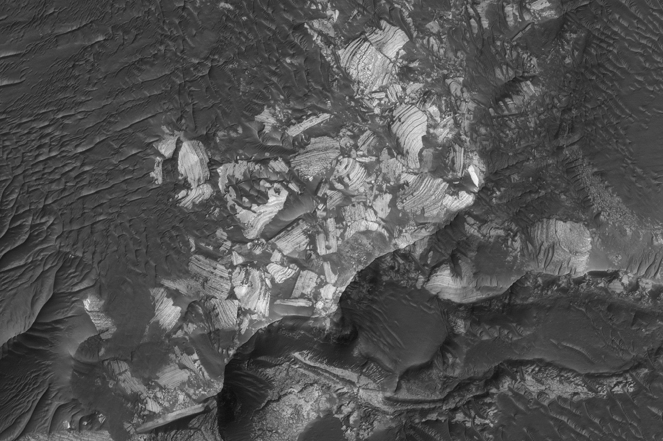
Jumbled, Broken Blocks of Layered Rock in Holden
The light-toned, layered rocks exposed in southern Holden Crater are so old that the layered materials were deposited, hardened to form rock, then later cut by a catastrophic flood that entered the crater from Uzboi Vallis. That flood broke-up the light-toned, layered rock, leaving some of it a jumbled mess, as shown in this sub-frame of MRO HiRISE image PSP_001468_1535 taken in November 2006. The area shown here covers an area approximately 385 by 535 meters (1263 x 1755 ft). North is up and sunlight illuminates the scene from the upper left.
Credit: NASA / JPL / University of Arizona / MSSS
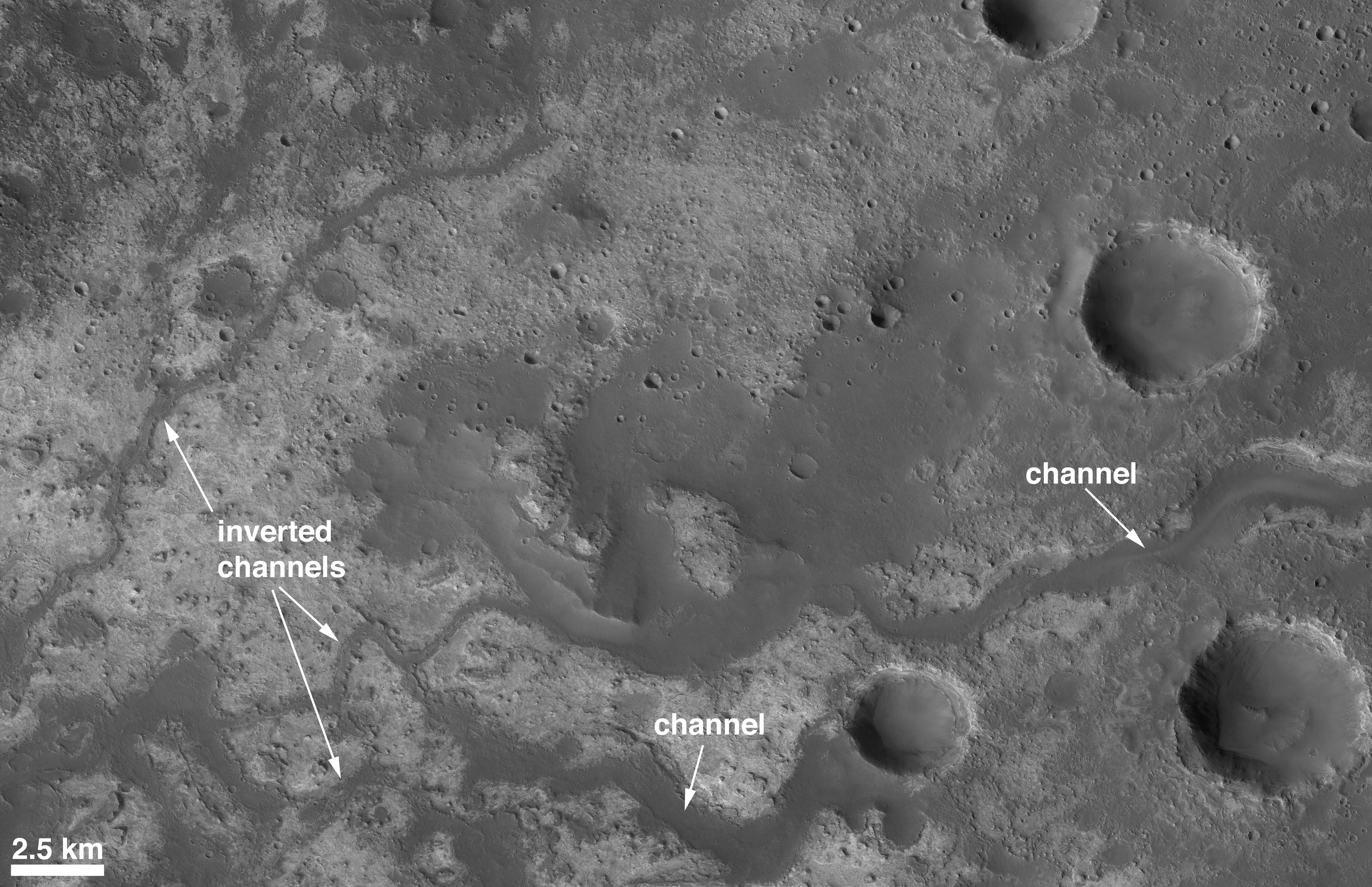
At Gale, the lower third of the mound has canyons cut into it. The floor of the largest canyon, on the west side of the mound, has the eroded and partially inverted remains of the river channel that cut the canyon. The period of erosion and canyon-forming on the Gale mound occurred beforelayers located even higher in the mound were deposited and hardened to form rock.
The "Grand Canyon" of Gale
This canyon occurs on the lower west side of the 5 km-thick mound in northern Gale Crater. It and several smaller canyons and troughs on the lower portions of the mound are evidence that the rocks MSL would study in Gale—at least during the first one or two Mars years it is on the ground—are so old that the layered material was deposited, buried, hardened to form rock, then re-exposed to the surface and eroded by running water (or similar liquid). The central part of the Gale mound contains layers of rock that were formed after this and the other canyons were created—in other words, there a lot of changing environments and conditions are recorded in the Gale mound. This picture is a stereo anaglyph (red left eye, blue right eye) composed of sub-frames of MRO CTX images P01_001488_1751_XI_04S222W and P02_001752_1753_XI_04S222W. North is up. The data were acquired in November and December 2006 and processed to make the anaglyph by Malin Space Science Systems personnel.Credit: NASA / JPL / MSSS
The point? The point is that, at Gale, Holden, and Mawrth, the rocks of interest to the MSL mission are so ancient that the sediment and/or ash and regolith that make up these layers were deposited, buried, cemented and hardened to form rock, before the rocks were cut by liquid water to form canyons (Gale), channels (Mawrth), and giant blocks of flood-transported sediment (Holden).
These landing sites each present Curiosity with an exercise in exploring deep time: the materials were deposited and lithified (turned to stone) so long ago that they were rock, pretty much as we see them today, back at a time when Mars was still wet enough that there could be new channels and floods of liquid water flowing on the planet's surface. Those fluvial events cut the rock that we want to study with MSL at each site. At Gale, more deposition of layered material occurred afterward, and those layers, too, became rock. Unlike the other 3 sites, at Eberswalde, the rocks we would like to study were not necessarily cut by water, but were instead deposited by water, in water.
All four MSL landing sites, then, tell tales of extremely ancient martian environments that involve water (or a similar, magical fluid) to transport and deposit sediment and erode landscapes. Some offer more than others: Gale has about 5 kilometers of strata to explore, Mawrth has only tens of meters to explore; the Eberswalde delta provides the best evidence for sedimentation in an ancient water setting anywhere on Mars; while the layered rocks in Gale, Holden, and Mawrth have been a bit more ambiguous in regard to what we can say about their depositional setting by looking at images taken from orbit.
Where will MSL ultimately land? There's going to be at least 2 more workshops—one in 2010 and one in 2011—to consider the landing sites. A decision is expected sometime after that final workshop in 2011. Two of the sites, Gale and Holden, require Curiosity to make a lengthy drive to get to the rocks that are of the highest scientific interest, one of the sites requires little driving (Mawrth), and Eberswalde presents a mix—rocks near the location the rover touches down may have been deposited in a lake, and thus could keep investigators busy for years, but the delta itself might be the Holy Grail for taphonomy—deltas are great places to trap all kinds of things, including evidence of dead organisms, that have washed down through the contributing river system.
If MSL lands at Gale or Holden, because of the driving needed to get to the stuff of interest, we call them "Go To" sites. Before you panic about, "Well, what if we never 'get to'?"—keep in mind that Go To may be the wave of the future. Some of the most interesting stuff on Mars is out of reach of the MSL landing system and out of reach of its mobility (driving) system. Being able to land and drive great distances is important. And you have to think of the time spent driving to the features of interest as being just like any other part of the journey: Launch, Cruise, and EDL (Entry, Descent, and Landing)—now you add "Go To" after EDL. If you want to fly to a distant city, you have to get to a local airport and then fly to where you are going. When you land, have you arrived at your destination? Or do you need to then find transportation to your hotel, your friend's house, or wherever you were headed? That last part—the transportation from the airport—that is "Go To."
What early Mars was like is important to understanding what early Earth was like. Earth's oldest rocks have not been preserved, thanks to vigorous erosion and plate tectonic forces. So, what was early Mars like? All four MSL landing site candidates seem to offer access to very ancient rocks in regions where water was still capable of flowing across the landscape and cutting into these rocks after they were already in place. Water played a role—and probably many roles—at each location.
I'm curious (ha, ha) to see what we'll find, no matter where we land.
Protect Our Shared Future
You help us defend humanity and prevent asteroid impacts. Donate now to become a Planetary Defender!
Donate