
 Explore Worlds
 Find Life
 Defend Earth


Curiosity update, sols 949-976: Scenic road trip and a diversion to Logan's Run
Written by
Emily Lakdawalla
May 6, 2015
Curiosity is finally on the road again! And she's never taken a more scenic route than this. Her path to Mount Sharp is taking her to the west and south, across sandy swales between rocky rises. I found it very hard to select panoramic views to include in today's blog entry because they're all so good. To begin, here's a recent route map by Phil Stooke, summarizing her travels.

Good views are generally synonymous with quality geology. The valley travel means that the rover team can do "roadcut science" -- imaging vertical cross-sections through many layers of rocks in the walls of the valleys. For instance, here are some stunning veins in the wall of the valley named Artists' Drive, which Curiosity photographed immediately to the west of Garden City.

Curiosity is shooting some of her best photos very nearly by accident. This, for instance, is the view she had after her drive on sol 951, part of the routine imaging she performs with her Navcams to get the lay of the land. It's a portion of an extra tier of three images they have begun to add to the top of routine post-drive Navcam imaging, because without it, they wouldn't see the full vertical extent of the path ahead. Topography: Curiosity is in it!

This was such a gorgeous view that they followed it up the next morning with a stereo color panorama. The embedded image really does not do justice to the view. You absolutely have to click through twice to enlarge it. It's worth it.

Every drive brings a new, breathtaking view, too many for me to include. This one, of "Mount Saint Mary", was taken the very next sol.
Curiosity has also been performing astronomy observations. The team commanded a series of images of the setting Sun on sol 956 as Mercury was transiting. I posted Damia Bouic's work on those images earlier today. They are stunning. I cannot see Mercury in the photos, but perhaps it is visible in the science data.

There was also Phobos and Deimos imaging on sol 964, and views of Phobos falling into Mars' shadow on sol 970. So far, these are all only available on the ground as thumbnail images, too small for detail -- Curiosity has been taking so many images that there's a bit of a downlink backlog at the moment.
The team was making rapid progress toward the next planned stop, named Logan Pass, when they spotted something interesting in routine forward-facing Mastcam images. Here's the relevant image, taken on sol 958:

Project scientist Ashwin Vasavada explained to me last week that geomorphologists on the team were intrigued by the shape of those lenses of rocky outcrop jutting out of the slope in the distance. The rock layers don't run straight through the hill; there are lenses of more resistant rock interrupting other materials. They don't look like much, but the shapes of those outcrops, combined with their location -- very close to the boundary between Pahrump materials and the overlying rock, known as the "washboard unit" -- made geologists on the team interested in what they may have to tell us about the relationship between the Pahrump and washboard units.
The team continued westward, keeping open the options of either visiting those rocky lenses or passing them by and continuing straight to Logan Pass. Here's the Navcam view on sol 960, after a 100-meter drive toward the outcrop.

Two more drives (interrupted by Curiosity's autonomous navigation detecting a rock it deemed potentially hazardous) brought them another 50 meters closer to the outcrops, now named Logan's Run. This was the view from the highest-resolution Mastcams on sol 964:

The team committed to visiting Logan's Run with a long drive on sol 967 that brought them close to the lowest of the rocky lenses, named Mount Shields, and took lots of images and zapped it with ChemCam. A bump on sol 971 brought them within arm's reach. It wasn't precisely where they intended to arrive; toward the end of the bump, the rover's wheels slipped in the sand quite a bit (which they had predicted and planned for), causing the rover to yaw to the right (which they couldn't really predict). It was still close enough for imaging and later arm work. It's quite a lovely outcrop, with its paper-thin rock layer plates. I can imagine it crumbling to dust at a touch; I wouldn't want to drill into this stuff!

They spent the weekend doing arm work: dusting off the top of the outcrop, taking a series of MAHLI close-up images, and analyzing its constituent elements with APXS. Despite the outcrop's apparent fragility, it held up to the brushing with no obvious changes. Here is a fun 3D animation of their efforts:
Then, after a bit more remote sensing work, they packed up and left.
What? you may be asking. After all that buildup? It is a little anticlimactic. But even though they chose not to stay to do more in-situ work, this little side trip was, to me, a pretty significant one: it's the first time I can recall that the mission identified a distant target that looked interesting enough in rover images to guide the rover's path there.
Navcam and Hazcam imaging has always guided Curiosity's immediate path choices, but medium- and long-distance route planning has always been done using images from the HiRISE camera on Mars Reconnaissance Orbiter. So it was very unusual that at Logan's Run, Curiosity spotted something from 200 meters away, with the Mastcam, which changed the rover's course. This used to be how the Spirit and Opportunity missions worked; until the advent of HiRISE, navigational targets were picked in rover images. It's funny that it's so rare on Curiosity. But I think it may become increasingly common, as Curiosity drives into areas with steeper topography. When rocky walls are closer to vertical, it is advantageous to look at them from the ground rather than from orbit. That is why Curiosity is there, after all! I do wonder if this will make operations more challenging. With navigation from orbit, the route is picked out way in advance. But if they are going to start doing more navigation based on rover imaging, there will be a lot more argument -- ahem, "discussion" -- about the rover's path under the much tighter time constraints of tactical planning.
Curiosity has one more month to work on Mars until the mission has to stand down for three weeks for conjunction. The physical alignment of Mars, Sun, and Earth has no direct effect on spacecraft health, but because the radio-noisy Sun gets in the way of the view from Earth to Mars, we won't be able to command our Mars spacecraft safely suring conjunction. So all Mars missions will have to button up into safe, stable configurations for a few weeks. Curiosity will continue to transmit some data to the orbiters and will carry on with daily environmental observations with REMS and RAD instruments, but won't receive any commands from Earth between June 3 and June 24.
One last thing to mention is that Curiosity performed full five-position wheel imaging on sols 962 and 963, something that the engineers like to do once every 500 meters or so in order to monitor their condition. I've looked at the wheel images closely and compared them to past images. While there has been more damage, the damage is in line with predictions, showing that the team understands the problem and that their methods of picking wheel-safe paths are working. The two rear wheels remain entirely free of punctures, as far as I can tell. The left middle wheel is still the most damaged one. Although it has a lot of holes, no grousers (cleats) are broken yet, which is a good thing. I plan to post a more detailed entry on wheel condition later.
Here are all the detailed updates on sol-by-sol activities from the USGS blog.
Sol 949 by Lauren Edgar: Leaving Garden City (7 April 2015)
After an extensive study of the veins at Garden City, it’s finally time to continue on our path down Artist’s Drive. We’ve collected a lot of really great data, including MAHLI images like this one from Sol 946, which will help us to determine the history of fluid flow through these rocks.
Today’s plan includes one last Mastcam multispectral observation on a bright block at Garden City, and a Navcam dust devil search prior to driving away. The drive will start by turning around so that DAN can make a measurement over the vein-rich area. After a drive of ~20 m, we’ll acquire images to be used to select targets in the Sol 950 plan. It’s really exciting to be driving again, and we’re looking forward to checking out the stratigraphy exposed in the valley walls along the way!
Sol 950 update by Lauren Edgar: Taking in the Scenery along Artist’s Drive (8 April 2015)
Like most tourists who visit Artist’s Drive on Earth, Curiosity is busy taking lots of photos to document the valley walls of Artist’s Drive on Mars. We are officially on the road again, and working our way through a very scenic drive.
I’m the Geology Science Theme Lead today, and today’s plan involves a pre-drive science block, a drive for hopefully ~30-40m, and some post-drive imaging for targeting. Unfortunately we have to be on a bit of a diet in terms of the total data volume that we can acquire. Back at Garden City we acquired a lot of really great data, and now we need to trim down so that we don’t acquire more data than we can downlink in a reasonable amount of time. The plan includes several large Mastcam mosaics to look at the stratigraphy exposed on the northwest and southeast valley walls, and post-drive Navcam mosaics to help select targets in the Sol 951 plan. We’ll also acquire Mastcam imaging to monitor atmospheric opacity. Tomorrow’s plan looks fairly similar to today – we’ll continue to drive and study the valley walls, taking time to appreciate the views along the way.
Sol 951 update by Ryan Anderson: 10k (9 April 2015)
We are continuing our driving tour of Artist’s Drive, and we should be reaching the 10k mark on Curiosity’s odometer in the sol 951 plan! The rover will start off the day with a targeted science block full of Mastcam observations. We are planning two Mastcam mosaics looking at the layers in the valley walls on either side of us, plus a routine “clast survey” image to document the soil and gravel at our feet, plus an observation of a portion of Mt. Sharp that is visible in the distance (which we have given the name “Tip Top Mountain”, even though we can’t see the top of the mountain from where we are), and a Mastcam image of the target “Joshua Tree.” It won’t be a purely Mastcam-filled block though: ChemCam has two long-distance Remote Micro-Imager (RMI) observations, also of “Tip Top Mountain” and “Joshua Tree.”
After the science block, the plan is to do a short drive to a location that gives us a nice long-distance view to help with drive planning. After the drive (and passing the 10k mark!), we will have our standard post-drive imaging so that tomorrow we can do targeted science again. There is also a post-drive Navcam movie to search for clouds and measure the wind direction overhead.
Sol 952 update by Ken Herkenhoff: Longer drive (10 April 2015)
MSL drove 18 meters on Sol 951, as planned, putting the rover in position to image the terrain ahead and plan a longer drive on Sol 952. The total "wheel odometry" for the MSL mission is now over 10 km! But the total traverse distance is still less than 10 km, because the wheels sometimes slip while driving, and the wheel odometry does not take slippage into account. So we're not quite ready to celebrate like the Mars Exploration project did when Opportunity recently completed the first extraterrestrial marathon.
The focus of scientific observation planning has been to get good images of the terrain as we continue driving, and before the Sol 952 drive the ChemCam RMI and Mastcam stereo cameras will image various targets near and far. Almost 100 meters of driving is planned, with the rover initially going to the right around the ripples shown here. After the drive, in addition to the normal images of the terrain near the rover, the Left Mastcam will acquire a full 360-degree panorama. It was an easy day for me as MAHLI/MARDI uplink lead, with only the normal post-drive images in the plan.
Sols 953-955 update by Ryan Anderson: Dumping Telegraph Peak (13 April 2015)
Our sol 952 drive went well, and we’re very close to crossing over into a new “quad” of the map that was made before landing (meaning we will get a whole new bunch of target names to choose from!). On Saturday the team planned for a lengthy ChemCam focus test on sol 953, where we collect images of the target “Eaton Canyon” at different times of day to check the influence of temperature. We also planned a nice big 20x2 Mastcam mosaic of “Mount Saint Mary”. On sol 954, we delivered some of the “Telegraph Peak” drill sample that we have been carrying with us to the SAM instrument, and dumped the rest out on the ground to be analyzed by APXS overnight.
Today we are planning for sol 955. We have Mastcam and a ChemCam RMI of the “Eaton Canyon” target again, as well as Mastcam and passive ChemCam of the dump pile. Mastcam also has a small mosaic in the expected drive direction and a larger 10x1 mosaic of “Tucki Mountain.” Then, shortly after sunrise on sol 956 Navcam will be taking an atmospheric measurement movie and Mastcam will measure the amount of dust in the atmosphere by looking at the sun.
Sol 956 update by Ryan Anderson: Mercury Transit (14 April 2015)
With the last portion of the Telegraph Peak sample delivered to SAM and analyzed by APXS, we are ready to keep driving. In the sol 956 plan, there is a quick science block in the morning, to allow the rover to take a couple of Mastcam pictures of nearby boulders called “Waucoba” and Navcam pictures to complete the 360 degree panorama of the area. After that, we have a couple hours of driving, which should take us into a new “quad” on our map of the landing site. After the drive, Curiosity will take standard post-drive images to allow us to make targeted observations in the sol 957 plan.
Later in the day there’s another science block, which will be spent making some ChemCam observations of the onboard calibration targets. Also in that science block, Mastcam will take a 3x2 mosaic in the direction of sunset. The reason for these images is that we have a special observation at sunset: Mastcam will be taking pictures of Mercury as it transits the sun, right before the sun dips below the crater rim. This will be the last chance to watch Mercury pass in front of the sun from Gale crater until 2024! Even without a transit occurring, I always like rover sunset pictures, so I’m looking forward to seeing how these observations turn out!
Sol 957 update by Ken Herkenhoff: Limited Downlink (15 April 2015)
MSL drove about 65 meters on Sol 956, then took some nice images of the path ahead. As we continue to drive each sol, acquiring images of the terrain around us is important to the science team. We don't want to miss anything! So the Sol 957 plan includes ChemCam RMI and Mastcam images of outcrops to the south and a Mastcam image of the windblown ripple right in front of the rover. After the drive, the usual imaging to support future planning will be acquired, but we don't expect to receive all of the data in time for tactical planning tomorrow. The volume of data expected to be relayed to Earth via MRO is smaller than usual on Sol 957, which was the only significant problem I had to deal with today as SOWG Chair. Sometimes more data are relayed than expected, in which case we'll get additional images of the terrain in the vicinity of the rover.
Sol 958 update by Ryan Anderson: Officially 10k! (16 April 2015)
The Sol 957 drive went well, and the rover has officially driven 10 kilometers! (Last week I announced that we had reached 10k, but that was 10k measured by how many times the wheels have spun, not how far across the surface of Mars the rover has gone. Now, no matter how you measure it, we’ve gone 10,000 meters!).
Unfortunately, we stopped with a ridge in front of us, blocking the view. So the plan for sol 958 is to do a short drive to get on top of the ridge so we can see farther to the south, allowing us to plan more effectively for future drives (and enjoy the scenery). Before the drive, we have some ChemCam passive observations of the sky to measure the composition of the atmosphere. There is also a Mastcam mosaic of an outcrop to the east, plus a high-resolution Mastcam observation of the target “Libby”.
After the drive, we will do some standard Navcam and Mastcam imaging so we can do targeted science in our immediate surroundings, plus a ChemCam calibration target observation, and a routine Mastcam “clast survey” image to measure the rocks and pebbles near the rover.
Sol 959-961 update by Ryan Anderson: Daughter of the Sun (17 April 2015)
The short drive on sol 958 was a success, placing us at the top of a small ridge, facing an outcrop dubbed “Daughter of the Sun”. The plan for sol 959 is to do some ChemCam and Mastcam of targets “Gold” and “Espinoza”, followed by several Mastcam mosaics. The biggest mosaic will be a 26x2 stereo mosaic looking toward Logan Pass. We also have a 7x3 stereo mosaic of “Daughter of the Sun” and a 17x1 mosaic of “West Ridge”.
On sol 960 we will do a long drive after which DAN will make some measurements and we will take our standard post-drive images. Then on sol 961 ChemCam will take some calibration measurements and then Mastcam and Navcam will make several atmospheric observations.
Speaking of taking pictures of the sky, we’re starting to get data down from our observation of the Mercury sunset transit. So far all we have are thumbnails, but it looks like the full-resolution images are going to be spectacular!
Sol 962 update by Ken Herkenhoff: MAHLI wheel imaging (20 April 2015)
The Sol 960 drive went as planned, for a total of over 102 meters! The rover has driven far enough since the last full set of MAHLI images were acquired that it's time to take another full set to look for more wheel wear. So my focus today as MAHLI/MARDI uplink lead was on planning wheel images. MARDI images are typically taken at each wheel-imaging position as well, but all of these images were well planned strategically, so it was an easy day for me. Wheel images will be taken at 4 spots, separated by short drives to ensure that all of the wheel surfaces can be examined. This takes enough time that there wasn't much room for other observations: Sol 962 begins with Mastcam mosaics of distant outcrops and images of the Sun and sky. After the rover stops moving, Mastcam and Navcam will take pictures of the terrain near the new rover position, and the Left Navcam will image the sun just before it sets to measure the distribution of dust in the atmosphere.
Sol 963 update by Lauren Edgar: Making a run for it (21 April 2015)
After cruising through Artist’s Drive, Curiosity set her sights on the next pass, known as “Logan Pass.” However, the science team realized that there’s an interesting outcrop to west of “Logan Pass,” which may help us to understand how these rocks relate to the section that we investigated at the Pahrump Hills. So we decided to make a run for it, and take a quick trip over to “Logan’s Run” to image those rocks first.
The plan today is to drive further to the west, and to do some additional MAHLI wheel imaging to monitor wheel wear. Prior to the drive we’ll acquire ChemCam and Mastcam observations on the target “Apple” – a small rock of variable tones. After the drive, we’ll acquire standard post-drive imaging for context and future target selection. The plan also includes several Mastcam nighttime observations of Phobos and Deimos to investigate the opacity of the upper atmosphere and aerosol size.
Sols 964-965 update by Lauren Edgar: Logan’s Run? Or just a short dash… (22 April 2015)
Although we had planned a drive of up to 48 m towards “Logan’s Run” on Sol 963, the drive ended early after only 17 m due to the detection of a nearby hazard (a large rock). This was the first time in a while that we were using autonav for driving. The good news is that the hazard was detected, and the events are understood. It just means that we have a little further to go before we can start calling this a run…
Today’s plan includes ChemCam and Mastcam observations on the large rock, now named “Blackrock.” Then we’ll continue driving towards the west. The plan also includes post-drive imaging for targeting, and some ChemCam atmospheric observations. I was supposed to be the Geology Science Theme Lead tomorrow, but we’re entering restricted sols (meaning that the data from today’s drive won’t be down in time for planning tomorrow), so we decided to plan two sols today, and will not do any planning tomorrow. Let’s hope this next run goes more smoothly!
Sol 966-968 update by Ken Herkenhoff: More Driving (24 April 2015)
The rover drove 32 meters on Sol 964, to a position that gave us a good view of the terrain ahead and outcrops of interest. So a longer (~90 m) drive is planned for Sol 967 after ChemCam and Mastcam observe nearby targets dubbed "Pablo" and "Pauline" on Sol 966. Mastcam, Navcam and REMS will also observe the atmosphere. I'm MAHLI/MARDI uplink lead today, and planned the usual post-drive images. CheMin will acquire calibration data overnight, and ChemCam will make calibration measurements on Sol 968.
In other news, the Mars Exploration Rover Opportunity tactical team planned Sol 4000 today! A drive is planned this weekend for Opportunity as well.
Sol 969-970 update by Ryan Anderson: Studying Mt. Shields (27 April 2015)
Our drive on sol 967 covered almost 90 meters, putting us in front of some interesting stratigraphy at "Mt. Shields", an outcrop along our drive down "Logan's Run". In the sol 969-970 plan, we have lots of Mastcam and ChemCam studying the outcrop. On sol 969, Mastcam has a 24x2 stereo mosaic and a 6x3 stereo mosaic of parts of Mt. Shields. Then, on sol 970, ChemCam has a bunch of standalone RMI “z-stacks” of targets “Flathead”, “Fern”, “Ginsight”, and “High_Park”. A z-stack is when we take a bunch of measurements at different focus positions. This allows us to merge multiple images to make sure the entire field of view is in focus. ChemCam also has a LIBS measurement of “Hungry_Horse”, which is accompanied by a Mastcam image of the same target. Finally, Mastcam will attempt to take some nighttime images of an eclipse of Mars’ moon Phobos, which can be used to infer how the amount of dust in the martian atmosphere varies with altitude.
Sol 971-972 update by Ken Herkenhoff: Approaching outcrop (29 April 2015)
This morning the MSL science team used all of the available data to decide whether to approach one of the nearby outcrops or drive away. Ultimately we decided to approach the closer of the large outcrops in front of the rover to set up for contact science this weekend. Planning is still "restricted," so we planned two sols of activities today. ChemCam and Mastcam will observe a nearby rock named "Helena," and the RMI will image a distant target dubbed "Lolo" on the morning of Sol 971. Then MAHLI will acquire a set of images of the wheels to track wear before the rover drives a few meters toward the selected outcrop. Overnight, CheMin will analyze the sample cell that was recently emptied to confirm that no material remains in the cell. On Sol 972, ChemCam will acquire calibration data, and Navcam will search for clouds. Finally, SAM will perform an instrument maintenance activity overnight.
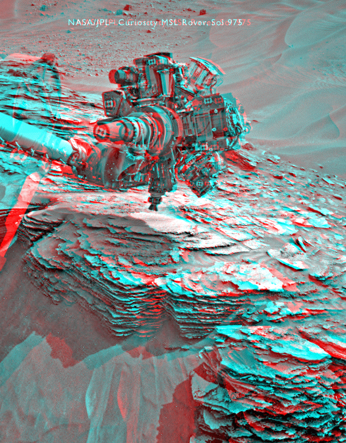
Sol 973-975 update by Ken Herkenhoff: Albert, Bigfork, and Charity (1 May 2015)
MSL is in a good position for contact science observations on an interesting outcrop of sedimentary rock, so the rover will be busy this weekend! We had to change the timing of the arm activities a bit to optimize the illumination of MAHLI targets, so it was a busy morning for me as SOWG Chair but I'm happy with the way the plan turned out. On Sol 973, ChemCam and Mastcam will observe nearby targets "Albert" and "Charity," the RMI will image a distant target named "Empire," and Navcam will search for clouds and dust devils. Overnight, CheMin will dump the remaining drill sample from one of its cells and measure the cell to confirm that the dump was successful. The arm will be deployed on Sol 974 and used to acquire a small MAHLI mosaic of "Bigfork," then place the APXS on the same target for an overnight integration. The rover will wake up earlier than usual to measure the amount of dust in the atmosphere at 8 AM on Sol 975 by imaging the sun. Later that morning, ChemCam and Mastcam will perform more atmospheric measurements, and the 100-mm Mastcam will be used to image some distant rock targets. In the afternoon, the Dust Removal Tool (DRT) will be used to brush the dust off of "Albert" and take MAHLI images of the brushed spot. The APXS will then be placed on the DRT spot for an overnight integration.
Sols 976-977 update by Ryan Anderson: Onward to Jocko Butte (4 May 2015)
With our weekend contact science done, it’s time to hit the road again. The sol 976 plan includes some final Mastcam mosaics of the interesting outcrops that we have been studying, plus a Mastcam multispectral observation of the target “Albert” that ChemCam zapped over the weekend. After that, we will drive about 60 m, to a location west of “Jocko Butte”. After the drive we have Navcam imaging to allow us to choose targets near where we stop, as well as take pictures looking back from where we just were, to view the outcrops from a different angle. Overnight, the SAM instrument will measure the amount of noble gases in the atmosphere. On sol 977, ChemCam will do some “passive” (no laser) atmospheric observations, Navcam will watch for clouds over Mt. Sharp, and Mastcam has a small 1x4 mosaic.
Protect Our Shared Future
You help us defend humanity and prevent asteroid impacts. Donate now to become a Planetary Defender!
Donate