 Explore Worlds
 Find Life
 Defend Earth
Bruce Murray Space Image Library
Mineral map of Endeavour's nearest rim
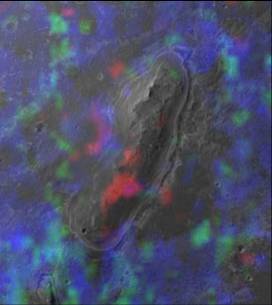
This mineral map comes from James Wray et al., "Phyllosilicates and sulfates at Endeavour Crater, Meridiani Planum, Mars," GRL, 2009.


Accelerate progress in our three core enterprises — Explore Worlds, Find Life, and Defend Earth. You can support the entire fund, or designate a core enterprise of your choice.
Give Today
Know the Cosmos and our place within it.
Empowering the world's citizens to advance space science and exploration.
Bruce Murray Space Image Library
This mineral map comes from James Wray et al., "Phyllosilicates and sulfates at Endeavour Crater, Meridiani Planum, Mars," GRL, 2009.