
 Explore Worlds
 Find Life
 Defend Earth


Mars Exploration Rovers Update: Opportunity Scales Knudsen Ridge and Rocks On
Sols 4274 - 4302

Written by
A.J.S. Rayl
Contributing Editor, The Planetary Society
March 3, 2016
Mars Exploration Rover
NASA / JPL-Caltech / Maas Digital
As the Martian winter slowly begins to recede, Opportunity is working away on the steep slopes of Knudsen Ridge at the southern end of Marathon Valley, showing her mettle in some of the most challenging terrain of the Mars Exploration Rover’s 12+ years on the Red Planet.
The veteran robot field geologist spent February in a mostly stationary position on a slope taking images of potential targets nearby, as well as additional images for the Knudsen Ridge Panorama with her Panoramic Camera (Pancam), and studying a rock.
Marathon Valley, which cuts west to east into Endeavour Crater’s western rim, is where the Compact Reconnaissance Imaging Spectrometer for Mars (CRISM), onboard the Mars Reconnaissance Orbiter, detected the signatures for a mother lode of smectite clay minerals more than seven years ago. Since arriving in the valley last July, the rover and MER scientists have been working to home in on the remnants of those ancient clay minerals.
Science, however, is a process and so far, even though the smectites appear from orbital data to be all over the valley, they have been elusive.
The MER team has been zeroing in on intriguing “red zones.” These areas, rich with deep red bands or stripes, seem to speak of past flowing water. And, the scientists are confident that they will find the rocks and materials in these zones are harboring the evidence they need to prove the presence of clay minerals there long, long ago.

Checking out Caugee
After spending the first couple of weeks of February 2016 taking images with her Panoramic Camera (Pancam), Opportunity turned her attention to a rock the team named after Charles Caugee, one of the boatmen hired for the Lewis & Clark Expedition. “It was there and regional and we decided to take a sniff,” said MER Principal Investigator of Steve Squyres, of Cornell University.NASA / JPL-Caltech
“We're hoping to take advantage of the steep topography that Mars provides us at Knudsen Ridge to get to a better example of the red zone material,” said Steve Squyres, MER principal investigator of Cornell University.
In previous months, Opportunity inspected several red zone rocks on the floor of Marathon Valley, where, according to mineral map created by Ray Arvidson, MER deputy principal investigator and CRISM co-investigator, and his students Washington University St. Louis (WUSTL), evidence for ancient smectites is hiding. In fact, this mineral map when laid over a topographical map of the area indicates “a one-to-one correlation” between the clay mineral signatures picked up by the orbital instrument and the red zones, according to both Squyres and Arvidson.
But the red zone rocks on the floor of the valley are “cruddy” and “crumbly” and turned out to be “a jumble of accumulated stuff,” as Squyres described them. The bedrock on Knudsen Ridge offers the scientists targets the rover can sink her instruments into, if, that is, she can reach them.
Scaling Knudsen Ridge has been challenging, but the rover continued to be a real trooper throughout February working from her perch on a 30-degree slope. “We have been climbing some of the steepest slopes of the mission and Opportunity has been showing us how sure-footed she still is,” said John Callas, MER project manager at the Jet Propulsion Laboratory (JPL), the “birthplace” of all NASA’s Mars rovers.
“This is the steepest slope Opportunity has been on since Karatepe on Endurance Crater,” added Squyres.
Demonstrating her right robot stuff, the rover showed no fear and has taken the climbing in stride. “Opportunity is making like a mountain goat,” said Matt Golombek, MER project scientist, of JPL. “But 30 degrees is just about our maximum on bedrock.”
Even so, by month’s end, the robot was pressing onward and upward. Cautiously inching farther up the 30-degree slope, Opportunity was heading toward in place bedrock in one of the red zones near the top of Knudsen Ridge. The target, promptly named Private Joseph Whitehouse, after another member of the Lewis & Clark Expedition, just may be the one that will release the clues the scientists need to prove the red zones are where clay minerals formed in the distant past.
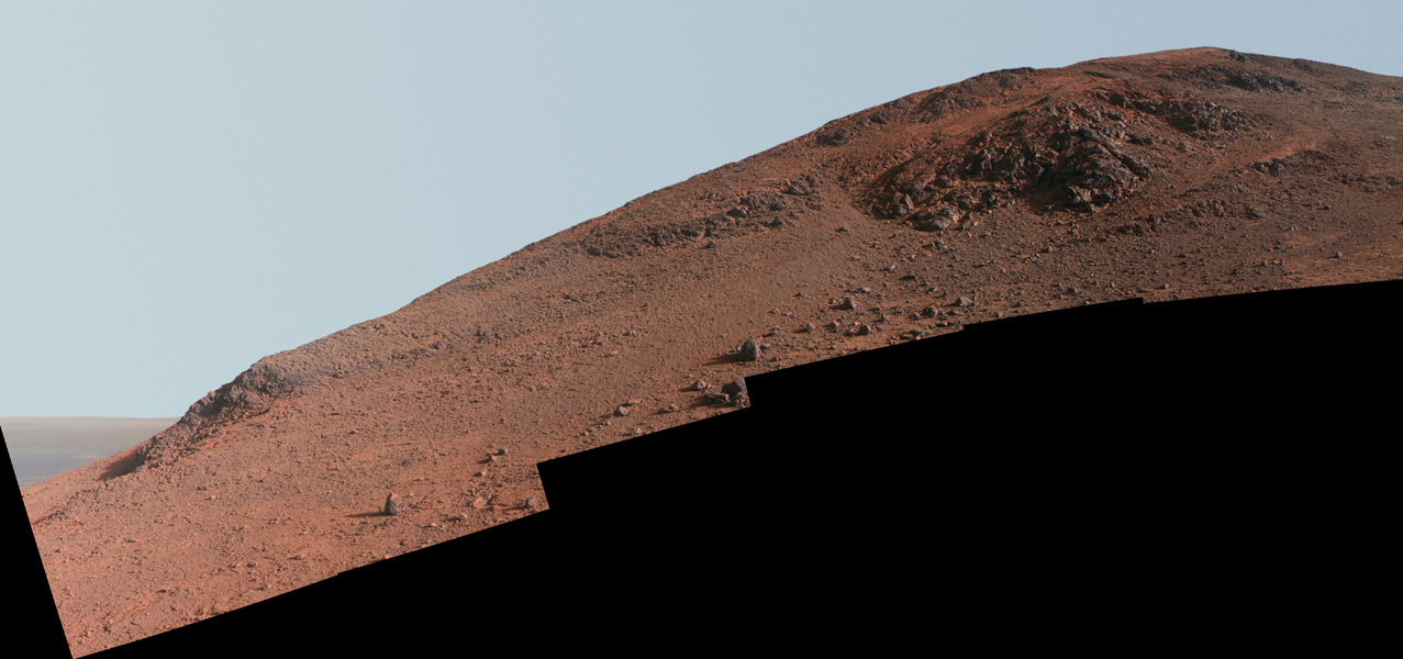
NASA / JPL-Caltech / Cornell / ASU
Knudsen Ridge
NASA-JPL released the above Knudsen Ridge Panorama on Feb. 25, 2016. Opportunity used her Panoramic Camera (Pancam) took the dozens of images that went into this image in October 2015 and finished filling in ‘holes’ in February 2016. The image above was processed by the Pancam team in enhanced color to make differences in surface materials more easily visible. Reddish rock, such as within and between the knobs near the top of the scene, is what the rover team calls "red zone" material. Red zone locations in Marathon Valley correspond to locations of clay minerals mapped from orbit.The rover began climbing Knudsen Ridge in late January. Despite the steep incline, the rover’s wheels slipped less than 20% as she hiked up the hill, as reported in last month’s MER Update. (The slip is calculated by comparing the distance the rotating wheels would have covered if there were no slippage to the distance actually covered in the drive, based on "visual odometry" imaging of the terrain the rover passes as it drives.)
Opportunity then parked on the ridge and spent the first two weeks of February primarily focusing her Pancam on her surroundings. “We took a couple of weeks to do extensive Pancam imagery of the area,” said Callas.
In addition to filling in parts of the ridge slope that hadn't been well covered yet, the color imaging provided the MER scientists with different perspectives on the geology and topography of the environs, as well as the kind of detail they need to direct the rover to the best surface targets for up-close investigations. “Pancam color imaging is now one of our main ways that we can help to identify potentially unique compositional materials to investigate with the Alpha Particle X-ray Spectrometer (APXS), after all,” said Planetary Society President Jim Bell, Pancam lead, of Arizona State University (ASU).
Between those imaging sessions, Opportunity handled other assignments. She took cloud movies with her Navcam and argon measurements with the APXS for the mission-long study on the Martian atmosphere. The robot also took care of routine science tasks like taking daily measurements of atmospheric opacity or dust in the sky overhead, known as Taus, and, with the help of her team, completed a needed engineering chore.
“On Sol 4284 (February 11, 2016), we napped instead of DeepSlept, because we had a lot of power and wanted to deep discharge the battery,” said Bill Nelson, chief of MER engineering at JPL. Discharging the battery serves a couple of purposes. “If you don't deep discharge the battery, it will slowly lose capacity, so this helps condition the battery. It also gave us much more depth of discharge data with which we updated our latest power model,” he said.
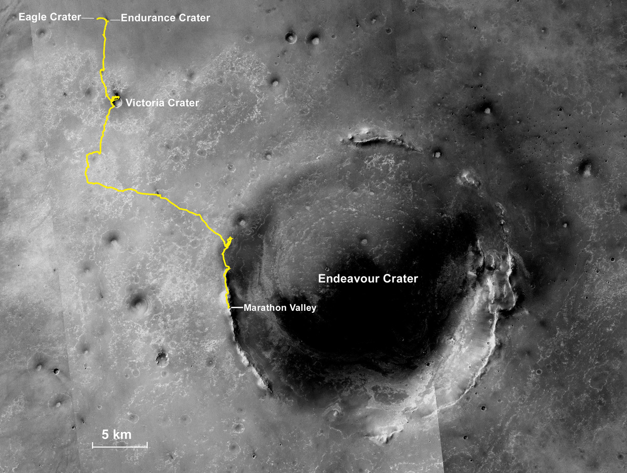
Oppy’s travel route
The gold line on this image shows Opportunity's route from the Eagle Crater landing site to her approximate current location. Since August 2011, the MER mission has been exploring the western rim of Endeavour Crater and in July the rover entered Marathon Valley. The base image for the map is a mosaic of images taken by the Context Camera onboard the Mars Reconnaissance Orbiter (MRO). Larry Crumpler, of the New Mexico Museum of Natural History and Science, provided the route add-on.NASA /JPL-Caltech / MSSS / NMMNHS
It turns out the power model for Opportunity and the MER mission’s seventh Martian winter was more conservative than the team members thought – which, of course, is good news – though they didn’t know that until they discharged the battery. In any case, winter is fading and the robot has the power she needs to keep on roving and working.
Opportunity handled the occasional tribulations with her usual MER flair and a little help from her friends on Earth. The following sol, 4285 (February 12, 2016), the rover uplinked her sol’s data to the Mars Odyssey orbiter, which in turn downlinked it to Earth through the Deep Space Network (DSN). However, a problem at the receiving station prevented the data from coming through.
Data limitations on the orbiter could have caused a loss of the rover’s science findings for that sol, but members of the MER and Odyssey teams didn’t let that happen. “We underwent some big pushups with Odyssey and with the efforts of a small number of people who came in on the weekend and the President's Day holiday, we got retransmission commands to Odyssey to downlink that data before new data came in that would overwrite this critical data,” Nelson said. And all was well that ended well.
With her errant flash memory still offline and operating in RAM only mode, Opportunity must off-load each sol’s data before she goes to sleep. Otherwise, since random access memory is volatile memory, it won’t be there. “We have carried on as normally as we can in RAM mode,” said Golombek.
Opportunity began the third week of February on Sol 4288 (February 15, 2016) taking more Pancam images of Knudsen Ridge. Two sols later, the team called it a wrap and that task was complete. (NASA-JPL would release the Knudsen Panorama, shown in this report, February 25th.)
Once she finished filling in the imagery needed for the Knudsen Panorama, the robot field geologist bumped about 68 centimeters (27 inches) on Sol 4291 (February 18, 2016) and turned her attention to a rock that the MER scientists thought may have been chemically altered by water billions of years ago. After the successful bump, the rover’s first wheel movement in February, Opportunity used her Pancam and Navigation Camera (Navcam) to take the usual documentary images of the immediate surroundings and, of course, the rock, which the team named after Charles Caugee, one of the boatmen hired for the Lewis & Clark Expedition.
About 20 centimeters (7.87 inches) in the long dimension, Caugee is “a rock-size rock that's sitting on slope down from steep outcrop,” said Golombek. It appeared to be a piece of scree or broken rock fragment that had fallen from just up the ridge. So the plan was for the rover to take Pancam images of the outcrop above the rock so the scientists could try to determine where exactly it came from.
“It’s what a geologist would do in the field,” said Arvidson. “Before you try to climb a scary cliff, first you look at the debris that’s fallen off to see if you can reconstruct the kinds of rocks you’ve got, based on the stuff that’s fallen off.”
Caugee visually appears more like the typical tan-red or Shoemaker Formation rocks so prevalent around the area. “It looks just like all the easy-to-get-to local bedrock,” said Squyres. “It was there and regional and we decided to take a sniff.”
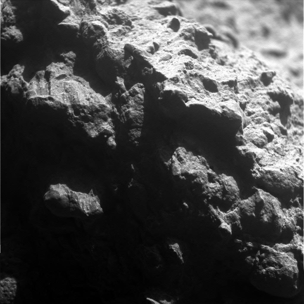
Caugee up close
Although Charles Caugee lies within red zone on Knudsen Ridge, the rock looks more like the typical tan-red or Shoemaker Formation rocks so prevalent around the Meridiani Planum area. Opportunity took this close-up picture with her Microscopic Imager (MI) on her Sol 4295 (Feb. 22, 2016). As it turned out, it wasn’t “particularly surprising,” said MER Principal Investigator Steve Squyres.NASA / JPL-Caltech
On Knudsen Ridge, the MER scientists hope to be able to reach and study bedrock that is directly in one of the red zone locations that so closely correlate with the phyllosilicate signature seen from orbit. That correlation alone, of course, “is not a smoking gun,” Squyres said. “We want to determine what it is about their chemistry that sets them apart and what it could have to do with water."
Although everything on Mars is red, there are varying shades of red and the so-called red zones are distinguished by deep red, as opposed to tan-red or rusty red features. “When we go into these red zone regions, we find deep red bands, these red stripes you can see in the images, and we believe they reflect an area that was altered by water, where waters once flowed,” said Squyres, clarifying what defines a red zone. “So far, when we’ve seen these things on the valley floor, they’re cruddy and a jumble of accumulated stuff.”
To test the hypothesis that water altered the red zone rocks and materials, the MER scientists began an experiment in January that aims to compare the chemistry of the more typical surrounding tan-red bedrock, which could represent an unaltered baseline, to the chemistry of red zone bedrock.
Opportunity used her diamond-toothed Rock Abrasion Tool (RAT) in January, to twice scrape and grind into a tan-red bedrock target named Private John Potts to glean its chemical composition. The robot field geologist’s in-depth investigation into this target did enable the scientists to establish a baseline for the rocks that are ubiquitous around this area and much of Meridiani Planum.
From Potts, the intent was “to go into an adjacent area and find more altered rock inside these red zones,” said Golombek.
Before hunkering down at the conveniently located Caugee however, the robot used her Navcam on Sol 4292 to take another cloud movie, and her APXS on Sol 4293 to measure argon in the atmosphere, and her Pancam to take images of a more tantalizing, bedrock target the team promptly named Private Joseph Whitehouse, which caught the scientists’ eyes. Just up hill from the rover’s location, “Whitehouse is in place bedrock,” said Squyres.
On Sol 4295 (February 22, 2016), Opportunity took Pancam images of a target dubbed Sand Divot, rolled her Navcam for another cloud movie, and took the necessary pictures with her Microscopic Imager (MI) for an up-close mosaic of Caugee.
The scientists wanted to determine the chemistry of Caugee with the APXS, which is part of every in-depth investigation the mission does these days. But the engineers were concerned about commanding the robot to touch it, given the rover’s somewhat precarious position on the steep slope. “Among our worries is that we're going to slip whenever we do something, so that's always in the back of our mind,” said Golombek.
The team was concerned that if Opportunity actually touched the rock with the APXS, it could trigger either the rock or the rover to move. “Neither is a pleasant thought, because the rock is almost directly uphill from us and we don't want it banging into the rover,” said Nelson. “And we're at a very high tilt, very close to our so-called static limit. If we go too much higher, we run a real risk of an uncontrolled skid and the rover could slide downhill until the angle levels out, so we're being very cautious about how we are applying forces to the rover.”
Just to make sure she hadn’t slipped or moved even in the slightest, the MER team commanded Opportunity to turn on her Rear Hazard Cameras (Rear Hazcams) to check her position. The rover was right where she was supposed to be.
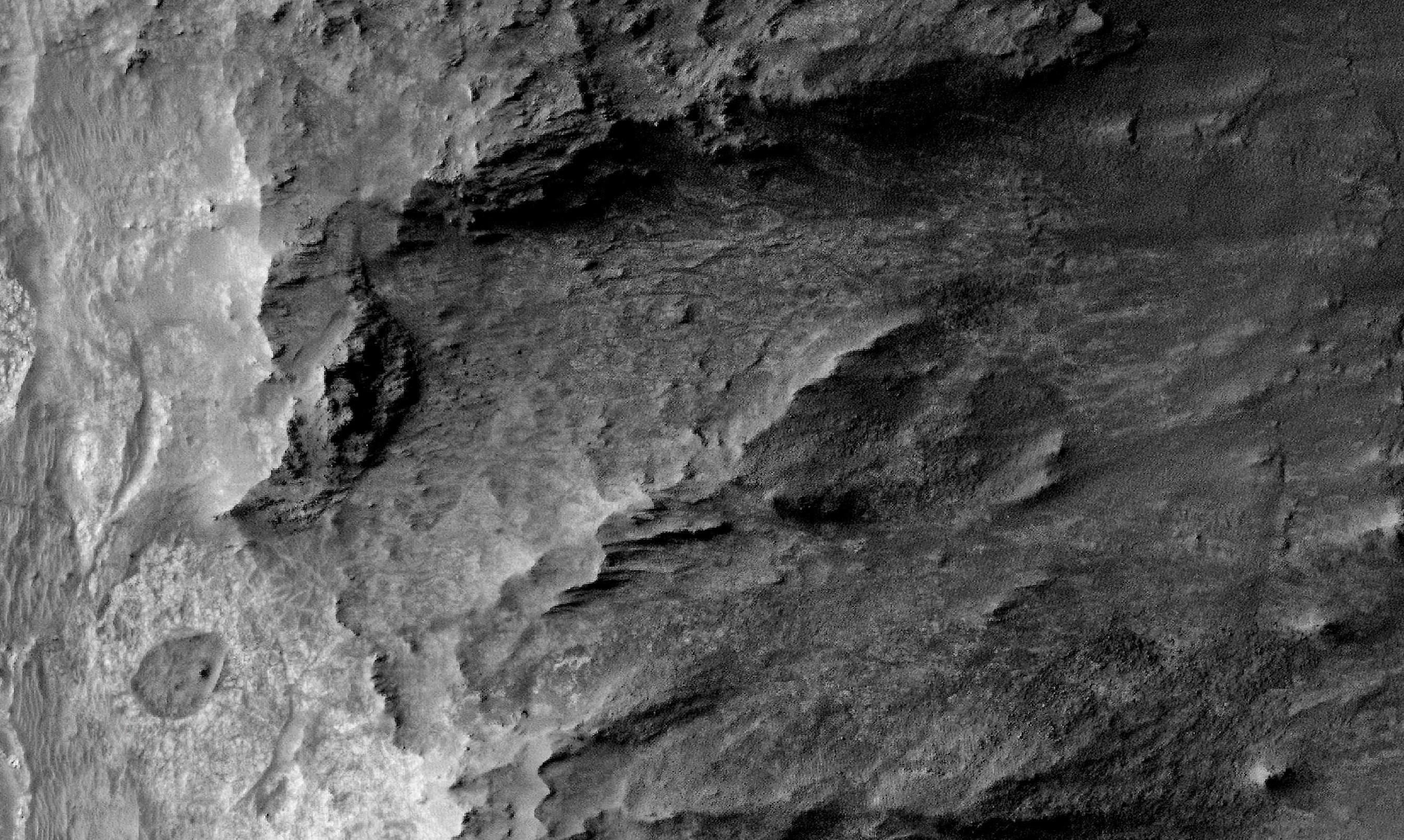
Overhead view of Marathon Valley
The HiRISE camera onboard the Mars Reconnaissance Orbiter took this overhead image of Marathon Valley. The valley stretches west to east about 330 meters (1100 feet) into the 22-kilometer (13.7-mile) diameter Endeavour Crater (to the right). Opportunity is now working on the valley's southern wall, at “a treasure trove" site that is rich with the remnants of clay minerals, according to orbital data.NASA / JPL-Caltech / UA
Next, the team commanded her to take more MI images of Caugee to aid the rover in precisely positioning the APXS to acquire the rock’s chemical composition. “We know where Instrument Deployment Device (IDD) or robotic arm is, because we have all the joint angles automatically taken care of, and by looking at which MI frame is in focus, we can better judge exactly where the surface of this rock is,” explained Nelson.
Normally, the rover locates the surface of a rock or target that the scientists want it to investigate up close by putting the Mössbauer Spectrometer down on it in a process called a Mössbauer touch. Although the radioactive power source of the iron-detecting Mössbauer faded several years ago, Opportunity continues to rely on the instrument to determine target surfaces.
“We press Mössbauer on a target and the instrument’s contact switch then trips. That tells us where the surface is, and then we can then came come back and safely place APXS on it,” Nelson said. “In this case, we used whichever MI frames are in focus to guide us to where that surface is. The plan was to hover the APXS just a millimeter or so above the surface, which should be close enough to get a good integration without actually touching the rock.”
Opportunity and the MER team succeeded. With the MI and APXS data in the can on Earth, the scientists quickly realized that Caugee is “nothing special,” as Squyres said. It turns out to be a piece of “float,” a loose piece of rock not connected to an outcrop. “It was not particularly interesting or surprising and kind of average in composition. We took a sniff and decided to move on.”
As February came to an end, Oppy and the MER team shifted their focus to the in place bedrock named Pvt. Whitehouse just uphill from Caugee. “Whitehouse could be pretty interesting,” said Squyres. “This one is bedrock. It looks like it may be a kind of broad alteration zone of what could be the reddish stuff.”
Getting to it will be tricky. “The problem is, it’s on a really steep slope, there’s loose stuff beneath it, and may be loose big chunks on either side of it, beside it and what we’ll be able to achieve on this remains to be seen,” Squyres said. “We’re going to try and get as close to as we can. It looks really tough, and as we move onto progressively steeper terrain, we’ll see more and more wheel slip.”
Still, the sheer angle of the Knudsen Ridge slope is not enough to stop this rover and this team from trying to get up close and personal with Pvt. Whitehouse. “We’re going to move in and take a closer look and we’ll see,” said Squyres. “At some point, it will become steep enough the rover won’t be able to make uphill progress. Because it’s really steep, if we get to any of Whitehouse it will be at the bottom of it.”
Whitehouse is certainly “reddish in tone,” Squyres said. “The thing that really attracts our eye to it is that it is a linear zone that is recessive relative to the stuff around it. So it’s a different color, a little lighter tone, and definitely more erodible than the stuff around it, what you would expect to see if it’s some kind of alteration zone.”
Whitehouse is “a little bit reminiscent of Esperance,” Squyres elaborated. “Is it that? No, it’s probably something different. The real key here is Whitehouse is bedrock, in place bedrock, and obviously different than the stuff around it.”

NASA / JPL-Caltech / Cornell / ASU
Knudsen Ridge 3D
Opportunity completed the dozens of images for the Knudsen Panorama above in February 2016. The Panoramic Camera (Pancam) team processed here in “3D,” by combining views from the left eye and right eye of the stereo camera (Pancam) so that it appears three dimensional when viewed through blue-red glasses with the red lens on the left. It was named for Danish astrophysicist and planetary scientist Jens Martin Knudsen (1930-2005), a founding member of the MER team.As the mission’s seventh Martin winter wears on, the Sun is rising steadily higher above the horizon, the sols are getting longer, and spring is around the bend. This is the time of year for small winds or gusters that whisk some of the accumulation of dust from the rover’s solar arrays. “And we’re seeing that,” said Squyres.
Not surprisingly, Opportunity’s power levels continued to improve in February. The robot field geologist began the month producing just under 500 watt-hours of energy, about half of her full capability when she landed back in 2004 with clean solar arrays. And, as the month came to an end, she was producing upwards of 540 watt-hours of energy, a respectable amount of power especially considering it’s still winter at Endeavour Crater.
The Tau or atmospheric opacity improved too, from 0.459 to 0.409, as did the robot’s solar array dust factor, from 0.683 at the beginning of February to 0.707 at month’s end, meaning the rover is utilizing 70% of the sunlight hitting her solar panels for power.
So, 12 years and one month into her mission – originally slated for 90 days – Opportunity’s future is still bright. “It’s looking really good,” said Squyres. “The rover remains in remarkable health. The power system is doing okay and is going back up. But, he added, pausing, “when you’re rover is this old, every day on Mars is a gift.”
In the sols ahead, Opportunity will continue her “electric slide,” six-wheeling across Knudsen Ridge. “We're going to stay on this north facing ridge because of the power levels we can get and we will continue to look for these red altered zones to see if we can pick apart the elements that are more abundant in those rocks,” Golombek summed up. “Hopefully that will lead us to what the clay carrier is.”
A super comparison
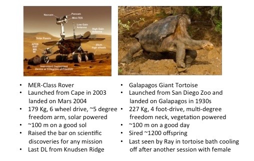
MER Deputy Principal Investigator Ray Arvidson took a little time away from the Red Planet in February to serve as the Washington University St. Louis alumni faculty host on the Santa Cruz II voyage to the Galápagos Islands in Ecuador. But Opportunity was never far from his mind and he just couldn’t help but compare the Mars rover to another indigenous “rover” on the island, named Super Diego.NASA / JPL-Caltech / R. Arvidson
On Earth, the MER science team gathered at Caltech on Thursday and Friday, February 25th-26th for its annual meeting. Following the standard tactical sessions and the usual exchange of science findings during the past year, Arvidson, on Friday, presented some “draft plans for traverses for the next two years that will meet key science objectives.”
The overall plan is for Opportunity to rove southward to look for the contact between the Shoemaker and Matijevic Formations. Past that, the word is ‘mum’ for now. “We’re just writing the proposal now,” said Squyres.
As remarkable as the MER mission has been and despite the textbook changing science still ahead and within reach and the engineering records Opportunity continues to set, there is still concern about whether the mission will be granted yet another extension. “There is always concern,” said Arvidson.
“We did well last time,” Squyres reflected. In fact, of all the planetary exploration missions up for review two years ago, the MER mission ranked second to Cassini, a NASA flagship mission.
But that was then and this is now and the MER team knows what it has to do. “Continued operation of the vehicle means it has to be not just a good proposal, but a competitive proposal,” said Squyres. That noted, he said: “I’m as excited about this proposal as I was about the last mission extension proposal. We’ve got a killer story to tell.”
Protect Our Shared Future
You help us defend humanity and prevent asteroid impacts. Donate now to become a Planetary Defender!
Donate