
 Explore Worlds
 Find Life
 Defend Earth


Europa on Earth: The Sulfur Springs of Borup Fiord Pass, Ellesmere Island
Written by
Stephen Grasby
July 19, 2006
From June 21 to July 6, 2006, a four-person team traveled to Borup Fiord Passto perform field studies of the geology and to gather ground-truth data to compare with satellite images that would be acquired at the same time. Periodically, expedition leader Stephen Grasby contacted The Planetary Society by satellite phone to report on their progress. Grasby's reports were summarized in The Planetary Society Weblog.
Europa on Earth? The sulfur springs of Borup Fiord Pass, Ellesmere Island
Over the coming two weeks, a four-person team of scientists will be traveling to the top of the world to explore a unique site on Earth where sulfur-rich waters seep from springs atop a glacier, and I will -- I hope -- be bringing you updates on the field expedition here. The site -- Borup Fiord Pass, on Ellesmere Island -- may be the best analog on Earth for the surface of Jupiter's moon Europa.
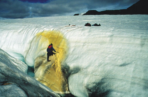
Stephen Grasby samples sulfur spring discharge
Stephen E. GrasbyThe site has been visited several times in the past by Canadian geologist Stephen Grasby, who has been studying its unique geochemistry. Apparently Steve was reading Scientific American one day and came across a story about Europa written by scientist Bob Pappalardo. In the article, Bob talked at length about the ruddy, sulfur-rich stains on Europa's icy surface, and their possible links to the composition of the subsurface. Steve immediately contacted Bob and told him about the Borup Fiord Pass field site as a possible analog to Europa. Now they're collaborating on an expedition, and Bob is sending along his graduate student, who'll be gathering data for her dissertation, on the chemistry and microbiology of this site, how ground data can be linked to remote sensing observations through aerial photography and hyperspectral imagery, and its applications to Europa.
A few months ago, Bob approached The Planetary Society because the team had exhausted their options for funding a key part of the trip, and we were as excited about the site as he was, so we stepped in with the remaining funding that they needed to get going. We only asked that they send us updates to keep our members informed about what the expedition encounters.
The four-person team leaves Calgary today; I've just heard from Steve, and they are on their way. They have satellite phones. We're hopeful that we'll be able to get emailed updates from them via the satellite phones, but they may just have to call me; I will do my best to report back to you about their experiences as I get any updates from them. In the meantime, here is some background information on the sulfur springs of Borup Fiord Pass. Stay tuned for further updates!
The Borup Fiord Pass expedition has departed
This is just a short note to say that the 4-person team of researchers who are off to study a possible Europa analog site on northern Ellesmere island left yesterday.
When I first heard about the possibility of this expedition late last year from Bob via our esteemed executive director Lou Friedman, my first reaction was "ooh--can I go?" Lou and I have both been lucky enough to get to take a trip to the Haughton Mars research station on Devon Island (in different years), but we did have very different experiences. Lou arrived at the beginning of the field season and spent most of the time being so cold that he wanted nothing more than to shiver in his sleeping bag. I arrived at the height of the season and enjoyed great weather -- it was still cold, but nothing that layers of capilene, fleece, and Gore-Tex couldn't cope with (you can read my blogs from that trip here).
I hope the Ellesmere Island expedition gets good weather, and that Bob's student manages to gather the data she's looking for. Expeditions like this, along with lab experiments and continuing mining of the data from Galileo and Voyager are all helping to prepare the scientific community to get the most out of a future mission to Europa -- if we can only get such a mission started!
Borup Fiord Pass Field Report: A Flawless Trip to Resolute
Update via e-mail from Stephen Grasby
The day started with frantic running of errands around town picking up the last few things needed for the field. Then we fought rush-hour traffic to get to the airport on time. The four us going north for artic field work (Benoit Beauchamp, Damhnait Gleeson, Marie-Eve Caron, and myself) all managed to arrive on time. Once on the plane we were able to relax and settle in for the long trip ahead.
The first leg was a four-hour flight from Calgary to Ottawa, arriving at midnight. We had just a few short hours of sleep as we had to be back at the airport for a 9:00 flight. It was a promising start to the day when we didn't get the 'green sticker' on our tickets. If the weather looks bad at Resolute, they might not be able to land, and the green sticker politely informs you that you have to overnight in Iqaluit at your own expense. The absence of the dreaded sticker says the weather looks good!
We boarded our first flight and made it to Iqaluit. The bright yellow airport greeted us along with a bit of rain. Iqaluit must be one of the few towns where you can walk from the runway to main street in 5 minutes. Even though it was a short layover we took the opportunity for a quick walking tour of town. Then it was back on board a smaller plane and on to the next stop of Nanisivik. The weather and scenery were both spectacular. Unfortunately there was little time to look around; it was just a short fueling stop and then back on board for the last leg to Resolute. We arrived under rare sunny conditions and where warmly greeted by the people of the Polar Continental Shelf Project, who will look after us during our short stay.
We had one scare when we where informed that the food we shipped over a month ago hadn't arrived. We were frantically making plans on how to scavenge from old supplies we had left years before -- would it still be edible?? Our worries quickly faded when we discovered that the shipment had ended up on our flight, arriving at the same time as us. It was quite interesting reading the waybill and all the various places it had been to during its month-long journey north.
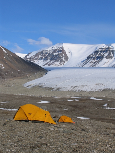
There's a Twin Otter airplane ready and waiting for our next leg first thing in the morning to go to Ellesmere Island, and a helicopter on site to take us the rest of the way. After three days of traveling we will finally be at our site and able to start some fieldwork.
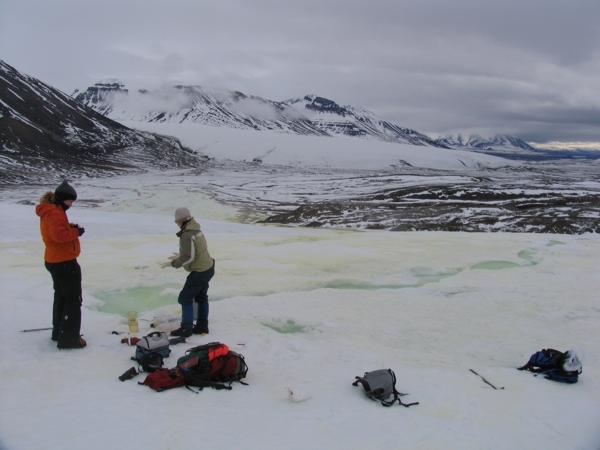
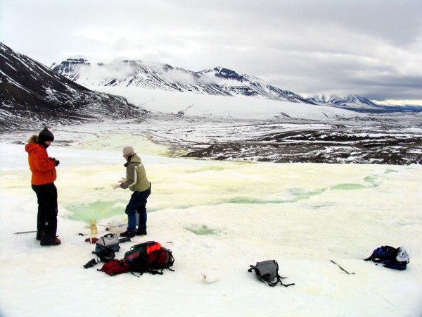
Borup Fiord Pass Field Report: Successful arrival at the field site
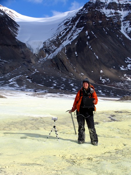
Sulfur spring at Borup Fiord Pass
The discharge stream flows away from the sulfur spring site down the front of the glacier.Stephen E. Grasby
I just got a phone call from Bob Pappalardo, who told me that his student Damhnait had just called him from the Borup Fiord Pass field site on Ellesmere Island -- a safe arrival! Since this is now secondhand info it'll be a brief report: Damhnait reported that she's there, they landed 6 or 7 hours ago, and "there's sulfur everywhere." That's good news, because the springs have had variable activity in past years. Bob also told me that the team was planning to do their helicopter survey in a couple of days, possibly on the same day that they'll be getting multispectral data from a satellite overflight.
So -- they're in the field and working!
Borup Fiord Pass Field Report: Sulfur everywhere, and a gushing spring
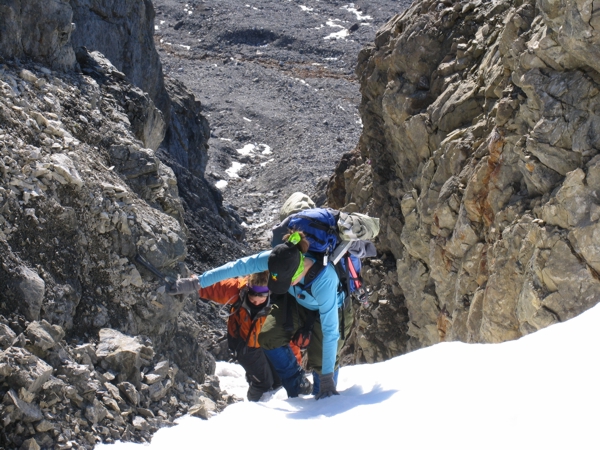
First day of fieldwork at Borup Fiord Pass
On the first day of fieldwork, we had to travel through deep snow to get to the spring site.Stephen E. Grasby
Home base for two weeks
Stephen E. GrasbyI just got off the phone with both Stephen Grasby and Damhnait Gleeson from the Europa analog field site on Ellesmere Island. Modern technology is great -- it wasn't much less clear than a typical cell phone call, yet they are standing at about 80 degrees north as they call. Amazing.
I did my best to scribble notes on what they said:
Stephen Grasby: "We got here yesterday, set up camp, and walked to the glacier. There's sulfur everywhere. There's a free-flowing spring on the front slope -- we haven't measured it yet but it's probably a couple of liters per second, very much stronger discharge than we've ever seen before." He said that this was due to their arriving earlier in the season than previously -- his past trips have all taken place in July. "It's just gushing out."
He said that there is a ton of spring activity, but it's in a different place than it has been in the past. "The sulfur has moved off to the east; there's a whole new system from previous years. There's also a much stronger H2S smell than before.
"We reconnoitered yesterday; it's raining today, so we spent most of the day in our tents. But we're seeing the clouds lift up off the fiords, up toward the peaks. We should be able to do some sampling tomorrow.
"We also found some filamentous bacteria where the stream is coming out; we'll sample that as well. Hopefully the rain will clear up and we'll be able to get some work done!"
Damhnait Gleeson: She spoke much faster than Steve -- clearly very excited to be there! "There is spectacular scenery here. We came in on a really small plane over the glacier -- the helicopter ride was great, flying up the fiords! The springs are in different places from past years. There's always a risk there's gonna be none; it was great to see all this activity." The sulfur could be spotted all over the ice from the air, she said.
Damhnait went on to say that they've planned their aerial helicopter survey for Monday, which is the same day that they'll be getting multispectral image data from a satellite overflight. "Hopefully it will be a pretty straightforward thing to pick out the sulfur on the satellite imagery. It's really exciting to be here, and we're really looking forward to getting out tomorrow and getting some work done!" Her doctoral dissertation will be, in part, on this work -- I wish her luck, lots of good weather, and easily interpretable data!
Borup Fiord Pass Field Report: Not only sulfur, but lots of salt in the springs
Collecting spring water samples
Stephen E. Grasby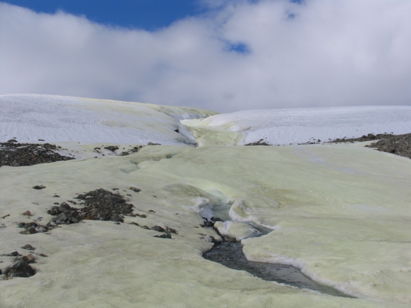
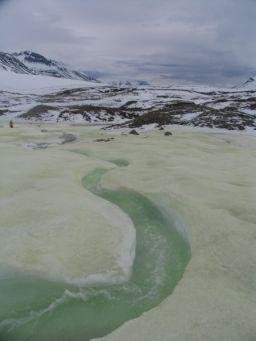
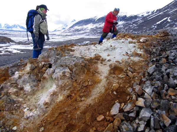
Sulfur-stained snow and ice, Borup Fiord Pass
Sulfur-stained snow and ice, Borup Fiord PassTaken from the base of the glacier.
Stephen E. Grasby
Marie-Eve Caron and Dahmnait Gleeson collect spring water samples
Stephen E. Grasby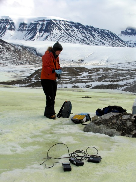
Dahmnait Gleeson collects microbial samples
Stephen E. GrasbyUpdate from Stephen Grasby
via satellite phone
"Yesterday we had another day of rain so we stayed in our tents all day. Today it was low clouds and fog so we couldn't get the helicopter in. But the rain had stopped, so we went over to the glacier and got some sore samples of the spring and measured the flow rate, and also got a number of samples for microbiological analysis. The springs are flowing quite well. We haven't calculated the flow rate yet -- we have to calibrate our instruments -- but it's probably two to three gallons a second, quite a high flow.
"It's a very saline water. What we sampled today was 10,000 milligrams per liter, about a third the salinity of seawater. We think this is coming from the buried Otto Fiord formation, buried evaporites. It's many times higher than what we saw in the past. I can't think of anywhere else where you could've seen a salt spring coming out of a glacier before. What we sampled before [in past years] was probably the last gasp of the sulfur water mixed with glacial meltwater, from later in the season. What we're seeing now is probably more pure spring water; so by coming earlier [this year] we get a much better picture of the springs.
"We're getting a strong feeling, too, that they probably flow through much of the winter -- you see a layer of snow and a layer of sulfur and a layer of snow. So you get the impression that the sulfur probably flows through the winter. We can't confirm that though without coming back in the winter.
"Our picture of the geology is also changing. We previously mapped a fold [down the axis of the valley] -- but I think that was just a misinterpretation of the air photos. The previous geologic mapping was done from air photos. When you're actually in this area it's just not consistent with that. We're going to try to work through that over the next couple of days.
"I went up on the glacier too, and started looking around but couldn't find any other spring outlets. So as far as I can tell this time there's just the one outlet. It's high up on the front of the glacier, probably 100 or 150 feet up on the glacier slope. I haven't got to the very top of the glacier yet. But we can't see any yellowing from higher up, so there's probably just one outlet this year.
"We saw an arctic fox today, so that was a bit of excitement. So it's good to have a day of work finally.
"So we're hoping for some continued good weather here, and Damhnait will try to do some spectrometery readings. It's starting to rain again now. This is unusual; it's a polar desert -- the average precipitation is 100 millimeters a year -- I've never seen constant rain before. It's a lot more rain than normal for sure. But we took advantage of it, we took a rain sample -- if you can't beat it, join it."
Borup Fiord Pass Field Report: Three days of glorious weather and lots of work
Geology fieldwork, Borup Fiord Pass
We climbed steep snow gullies in order to get a better look at the local geology.Stephen E. Grasby
Dahmnait Gleeson takes spectral measurements
Stephen E. Grasby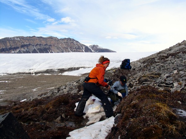
Marie-Eve Caron and Dahmnait Gleeson collect water samples from bedrock spring
The glacier site is in the background.Stephen E. Grasby
Marie-Eve Caron and Benoit Beauchamp examine possible paleo-discharge site
Stephen E. Grasby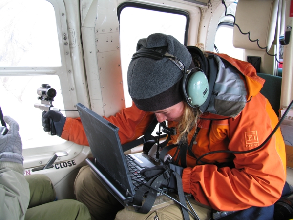
Dahmnait Gleeson takes spectral measurements from the helicopter
We collected spectral data from a helicopter hovering over the sulfur spring.Stephen E. Grasby
It's been three days since the last report. On Tuesday, Steve Grasby spoke by phone with Mat Kaplan, for Monday's Planetary Radio show; he didn't call me that night or the following one, but I got a satellite phone call from a very happy Damhnait Gleeson this evening, and quickly learned why they hadn't called -- too busy!
Here's what I could write down from Damhnait's recitation of three days of work in Borup Fiord Pass.
"It's been fantastic! The sun is shining here, the sky is completely clear; we're very happy to have a bit of better weather to do some work.
"Tuesday in the morning we went out and we were looking at some of the formations in the area, checking the geology. We came across an interesting site that seemed like a paleo-spring site; this was way beyond the point where the ice has retreated to. The spring could have been operating beneath the ice once, or it could have been operating after it retreated, but judging from the glacial deposits on top of it it was probably under the ice. In the afernoon I was able to get out on the ice and get some spectra.
"On Wednesday we got our helicopter day, so that was cool! We started out with an aerial survey of the glacier, and we did a fly-over the whole area. We saw these vast ice fields and all these glaciers pouring down these different valleys, it was really spectacular. We took the helicopter out to the coast, and saw these outcrops of gypsum and evaporite deposits, the most beautiful rocks carved by water, and all these layers in the rocks, we all came back with all these rocks weighing down the helicopter -- we're geologists, that's what happens!
"We were flying around and seeing a lot of stuff, the whole area is spectacular. We visited this old field station called [Riverville]?" I couldn't understand the name of the place, I'll have to ask when they return. She went on: "And it was these prefab buildings, they haven't been used in like 20 years or something. There were all these food supplies and a huge wall full of spices and weird old food from the 1970s like whole canned chickens! There were things like tractors, old-fashioned snowmobiles inside, they're probably still good, it was funny to see all that stuff there -- we have funny pictures. I guess it's too hard to take that stuff out once it's been brought." When they return I'll get pictures from them and post a photo album.
Damhnait continued: "We were flying over these big areas, but the only sign of life we saw the whole day were these little herds of four or five musk ox. We saw one lone solitary seal on the ice beside its hole, and when we flew over it dove in. It's incredible how little life there is out here."
I asked her if they'd seen any other springs besides the one they'd been visiting already. "No, just the one we're working on seems to be the only one active this year.
"Today was a geology day, we spent the entire day clambering up these sheer cliffs and getting back down them. We did some investigation of the east-west fault, then were climbing up along the fault along these snow and ice talus slopes. We're learning more all the time, just trying to fit pieces of the puzzle together. It's just absolutely wonderful. There's not even a cloud in the sky now." There's some information on the regional geology, including the fault she's talking about, on this page about Borup Fiord Pass.
Stay tuned for further updates; the team expects to be in the field until around a week from today.
Borup Fiord Pass Field Report: Bad luck for first attempt at satellite imaging
I got an email from Bob Pappalardo letting me know that the first attempt to acquire multispectral imagery from the USGS EO-1 satellite across Borup Fiord Pass, which took place on June 26, was clouded out. This of course we knew from Damhnait Gleeson's reports from the field. But according to her report two days ago, the weather had improved. The satellite will be shooting an image again today; hopefully they'll have better luck!
This image was taken by the Landsat satellite on a much clearer day several years ago -- I include it here just to show you what they were hoping to see, and approximately where the EO-1 Hyperion image swath should have fallen.
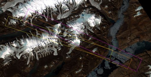
Footprints of Hyperion multispectral images across Borup Fiord Pass
This Landsat satellite image covers the area of Borup Fiord Pass (north-south valley just to the left of center in this image). The colored rectangles on top show the areas of EO-1 Hyperion multispectral image swaths. Each swath is 7 kilometers wide.Landsat-7 image, courtesy of Bob Pappalardo
And here is a thumbnail of the actual swath they got back from the satellite. EO-1 will re-try the imaging at least once if there's more than 25% cloud cover; I'll say there's a wee bit more than 25% cloud cover in this picture!

EO-1 Hyperion swath across Borup Fiord Pass
EO-1 Hyperion swath across Borup Fiord PassThe USGS EO-1 satellite acquired a swath of multispectral image data across Borup Fiord Pass on June 26, 2006, at the same time that a field expedition led by Stephen Grasby was examining sulfur springs in the area. Unfortunately, it was a very cloudy day.
USGS
Borup Fiord Pass Field Report: Fieldwork is almost done
I just got another phone call from Stephen Grasby at Borup Fiord Pass on Ellesmere Island, updating me on the status of their fieldwork, and it sounds like it's been a productive trip.
"We've been having continued nice weather. We've had some longer days hiking up the mountains to look at the local geology, so we're getting a much better understanding of the regional geology. Damhnait has finished all her spectral work. She was waiting for a sunny day to do her grid work -- she's walked out a large grid area to compare to the satellite images. As far as she's concerned she's accomplished everything she needed to get done on this trip. We'll spend the last few days on the geology, and get a few more water samples. If the weather holds out it should be a complete success for everybody here.
"The spring is still flowing at the same rate, it seems to be pretty much constant so far. We plan to go there tomorrow to see if there's a change in the water chemistry. Things are really starting to melt now; once the glacier melts at the bottom, it may shut down the spring.
"Yesterday about five musk-ox came through the camp, so we've seen some wildlife. There's a hint of a front coming through, some high cirrus clouds, but it's shorts weather today -- we were out in shorts and T-shirts much of the day, it's quite warm, about 10 degrees Celsius [50 Fahrenheit]. The wind was calm and it was very sunny on the rocks, and we were hiking up the mountains so that warmed us up; but as soon as you get in the shade it gets quite cool.
"We've looked all around, and there's no sign of any other active spring sites for this year. We're also getting a much better understanding of what the geology is. We no longer think there was a big anticline running through the valley, so we're just reinterpreting what we're seeing. It's still not obvious why there's such a low valley here; there's nothing here that would give any reason for it. The regional geology is proving to be much more like we're in a mountain belt like the Front Range of the Rocky Mountains, a fold-and-thrust belt pushing the rocks from north to south."
Steve has only one worry about the trip, and that's the status of the satellite imaging that they were hoping to acquire simultaneously with all of Damhnait's ground-truth readings. "The two days it was scheduled for satellite images, it was cloudy here; and since everything is melting so fast it's running off the outwash, about 20% of the sulfur is gone already." He said that the second day of satellite imaging had been planned for July 1, and if it happened in the morning they were out of luck; but that things had started clearing in the afternoon. I looked up the info and found that it had been scheduled for 19:38 GMT -- he said maybe that might have been a good time. I'll be looking forward to an email from Bob Pappalardo with the thumbnail from that pass.
Borup Fiord Pass Field Report: Clouds still stymie satellite imaging
Bob Pappalardo sent me a thumbnail image representing the second attempt of the EO-1 satellite to acquire a multispectral image across the Borup Fiord Pass field site, and though it's slightly less cloudy than the first one, it's still pretty completely covered up:

EO-1 Hyperion swath across Borup Fiord Pass
The USGS EO-1 satellite acquired a swath of multispectral image data across Borup Fiord Pass on July 1, 2006, at the same time that a field expedition led by Stephen Grasby was examining sulfur springs in the area. Unfortunately, it was a very cloudy day.USGS
Too bad! They will try again for two more satellite passes, but both will fall after the crew has left the field (which was supposed to happen today or tomorrow).
In the meantime, just to prove that satellites do catch this area without clouds sometimes, here's a link to the Google maps view of Borup Fiord Pass (thanks to Doug Ellison for the link).
Borup Fiord Pass Field Report: Return to REsolute
Returning home from Borup Fiord Pass
The four of us were dropped off by a helicopter and waited for a Twin Otter airplane to land to take us back to Resolute.Stephen E. Grasby
First day of fieldwork at Borup Fiord Pass
On the first day of fieldwork, we had to travel through deep snow to get to the spring site.Stephen E. Grasby
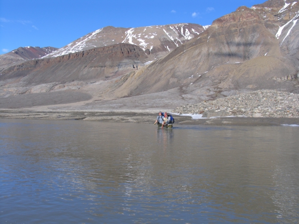
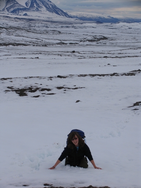
Last day of fieldwork, Borup Fiord Pass
hile we've been in the field, all the nice snow that had been there when we arrived has been converted into waist-deep rivers that have to be crossed.Stephen E. Grasby
Stephen Grasby called this evening from Resolute; the field expedition is over. They've spent the last couple of days continuing the work on the field geology. Today was a good travel day, and the helicopter came to pick them up as planned; the team are all ensconced in the hotel in Resolute, having happily enjoyed showers.
"We flew over the site again in the helicopter and the spring was still flowing pretty steadily," he said. "We didn't see any change at all in the flow rate while we were there."
They have made another interesting observation about the spring. During the days they've been at Borup Fiord Pass, warm summer weather has melted almost all of the winter snow. So the formerly white valley is now brown -- except at the location of the spring's outlet. What gives? Steve explained that as the spring flowed during the (otherwise mostly dry) winter, its waters would freeze at the location of the outlet, building out the outlet. Occasional snow falls would coat the valley and the stream outlet. When the warm weather arrived, all that snow melted first, but the ice formed at the spring outlet will take longer to disappear. "It must start running very early in the season, or maybe run all winter," Steve said. "When the snow started melting, the only place there was still ice was where all the sulfur was."
Steve said that the change has been pretty dramatic during their short stay in the field. He had been looking through his photos this evening, selecting some to send to us (he would have sent them tonight but the wireless access in the hotel wasn't working; he said he'd try to find a hard wire tomorrow). "The first image [from the field site], there we are in waist-deep snow; today there was no snow to be seen."
In addition to being a useful clue to the longevity of the spring, the iciness of the spring outwash could also serve a useful purpose. Both of the attempts to get satellite image data of the field site were clouded out; the next attempts won't take place until July 11 and 16. Bob Pappalardo told me he was very concerned about not getting satellite data of the site for comparison to the spectral data that his student Damhnait Gleeson acquired while she was there on the ground, especially because the melting of the snow and ice was apparently washing all of the sulfur staining away. But, Steve said, "Where the sulfur is, the ice hasn't started melting yet. It's still pretty thick, almost as much as when we got in. Hopefully it'll hold out a couple of days, and we'll get the satellite view."
I hope to have those pictures for you tomorrow!
Borup Fiord Pass Field Report: A photo album
Stephen Grasby found Internet access in Resolute yesterday and was able to send an email and a few photos from their trip.
"We are back in Resolute after successful field work. The spring was running much higher than ever seen before, the water chemistry was significantly more saline than before (not to mention much more stinky), and we belive we have good evidence that it runs through the winter (need to confirm this by going in April (we've been talking about the logistics already - brrrr). We also believe that we may have found some old discharge sites in berock in front of the glacier but need isotope data to confirm. Dahmnait was able to get good spectral data from both walking around and in the air. We have remapped the geology and threw out the old idea of a large fold running down the valley, it looks more like a graben structure, a large down-dropped block. We still need to work on some things to finalize the new model though. As with all successful field work we have ended up with more questions than answers so we hope to get back next year.
[The photos are now included inline with the previous weblog entries.]
Borup Fiord Pass Field Report: Success at last for the satellite imaging
Bob Pappalardo emailed me this morning to let me know that the EO-1 satellite acquired a "makeup" image of the Borup Fiord Pass field site on July 6, the day the four fieldworkers left the site, and that it finally found a relatively cloudless day! The image is the one farthest to the right below. I thought I'd display the three satellite images acquired so far side-by-side to aid in attempts to match features between them. I believe that all three swaths are close to east-west in their orientation; east is to the top.
 June 26 |  July 1 |  July 6 |
I realize now that you actually can see the glacier in the July 1 image, but it's pretty deeply shaded by clouds. I think they are still planning on one more imaging attempt tomorrow -- if that works, I'll be curious to see if we can spot any change in the snow cover.
To help visualize where those swaths are, here's a satellite map for context.
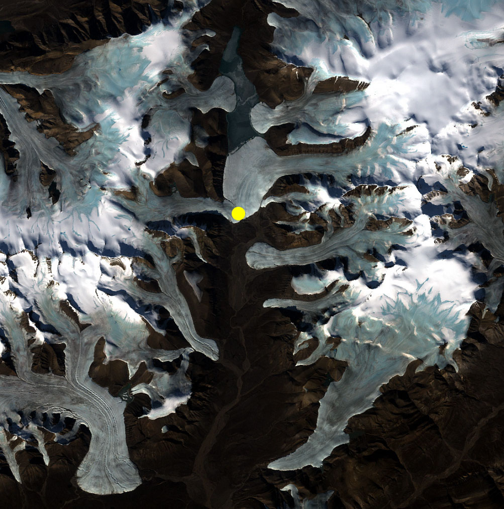
Satellite image of Borup Fiord Pass, Ellesmere Island, Canada
Borup Fiord Pass is a north-south trending valley on Ellesmere Island. Many mountain glaciers spill into the valley from each side. The yellow dot indicates the location of sulfur-rich springs that seep through the ice.Stephen E. Grasby
Borup Fiord Pass Field Report: More quality satellite images
Bob Pappalardo emailed me this morning to say that the last set of satellite data for the Borup Fiord Pass field trip had been acquired, and like the previous one it is nearly cloudless and sharp. This one (farthest right below) was acquired ten days after the expedition ended. The strips below are just thumbnails; the team will examine all the strips and decide which ones are likely to be worth purchasing from the USGS. Obviously the July 6 one will be a good choice. This one is excellent too but because it was acquired so long after the expedition ended it's not quite as valuable for the ground truth comparison. They have also been debating whether to buy the July 1 image -- it's not very good, almost completely covered by clouds, but you can at least see the field site through a gap. Bob told me he'd send along the full-resolution data for me to post when he got it.
June 26 | July 1 | July 6 |  July 16 |
Protect Our Shared Future
You help us defend humanity and prevent asteroid impacts. Donate now to become a Planetary Defender!
Donate