
 Explore Worlds
 Find Life
 Defend Earth


Looking at Mars with the MRO CTX

Written by
Ken Edgett
Senior Research Scientist, Malin Space Science Systems
May 29, 2009
by Ken Edgett
My time at work is largely divided into three parts: supporting the on-going Mars Reconnaissance Orbiter (MRO) mission, helping to prepare for the upcoming Mars Science Laboratory (MSL, Curiosity) rover mission, and contributing to a lengthy "final report" on the Mars Global Surveyor (MGS) Mars Orbiter Camera (MOC) investigation. Some weeks, one or the other of these activities may dominate my time, and other weeks, I may be working on proposals for future work. Today, my mind is on MRO.
At Malin Space Science Systems, we are operating two of MRO's cameras -- the Mars Color Imager (MARCI) and the Context Camera (CTX). The MARCI provides daily global views of the planet's weather. Malin Space Science Systems (MSSS) releases a weekly review of the weather here: http://www.msss.com/msss_images/latest_weather.html. The data from MARCI also provide 5-band color spectra at about 1 kilometer per pixel scale, track the coming and going of the seasonal polar caps and changes in albedo patterns, and observe Mars in the ultraviolet to examine daily changes in atmospheric ozone and water vapor distribution.
The other camera, CTX, acquires grayscale images that typically cover an area 30 kilometers wide by up to 313 kilometers long at 6 meters per pixel.
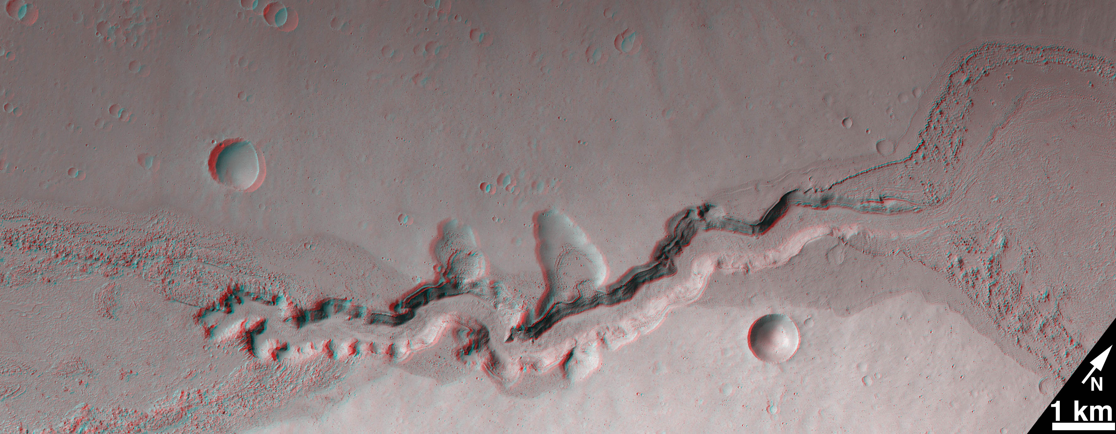
Cataract in Kasei Valles
This stereo anaglyph (red left eye, blue right eye) shows a valley cut by flowing, mud-laden water at the bottom of Kasei Valles. The narrow canyon you see here was cut by headward erosion -- the water flowed from left to right; the canyon's head (left) used to be all the way over near the right side of the image. As water passed through the area and to the right, the channel lengthened toward the left. We discovered this feature using the Mars Global Surveyor (MGS) Mars Orbiter Camera (MOC) earlier in this decade; it was the subject of a paper by Rebecca Williams and Mike Malin in 2004 (doi:10.1029/2003JE002178). The anaglyph was prepared by Malin Space Science Systems personnel and is composed of sub-frames of CTX images P03_002287_2005_XI_20N072W and P05_002788_2005_XI_20N072W. The cataract is located near 21.0°N, 72.7°W; north is toward the upper right.
Using CTX, we have imaged about 42% of Mars at full resolution. One might think that, since we've done 42% of Mars since late September 2006, we should be able to cover 100% by sometime in 2013. But full coverage of the planet at 6 meters per pixel is not a current objective of the CTX investigation. The reason: we also like to repeat things. Repeated coverage allows us to obtain stereo pairs and monitor selected areas to see if things are changing. In addition, some repeated coverage is inevitable when you're trying to build up a mosaic of an area -- you want the edges of the images to overlap a bit.
So, what are we doing with CTX?
As the name implies, the first objective of CTX is to provide context for the data being acquired by the other instruments aboard MRO. In particular, we often acquire images at the same time that the HiRISE and CRISM are taking data. HiRISE (High Resolution Imaging Science Experiment) can see objects of about a meter or two across, and CRISM (Compact Reconnaissance Imaging Spectrometer for Mars) is the near-infrared spectral imager which is providing many new clues about minerals on the martian surface. The CTX images allow investigators using HiRISE and CRISM to extend what they learn from those data to the larger areas covered by the wider field of view of the CTX.
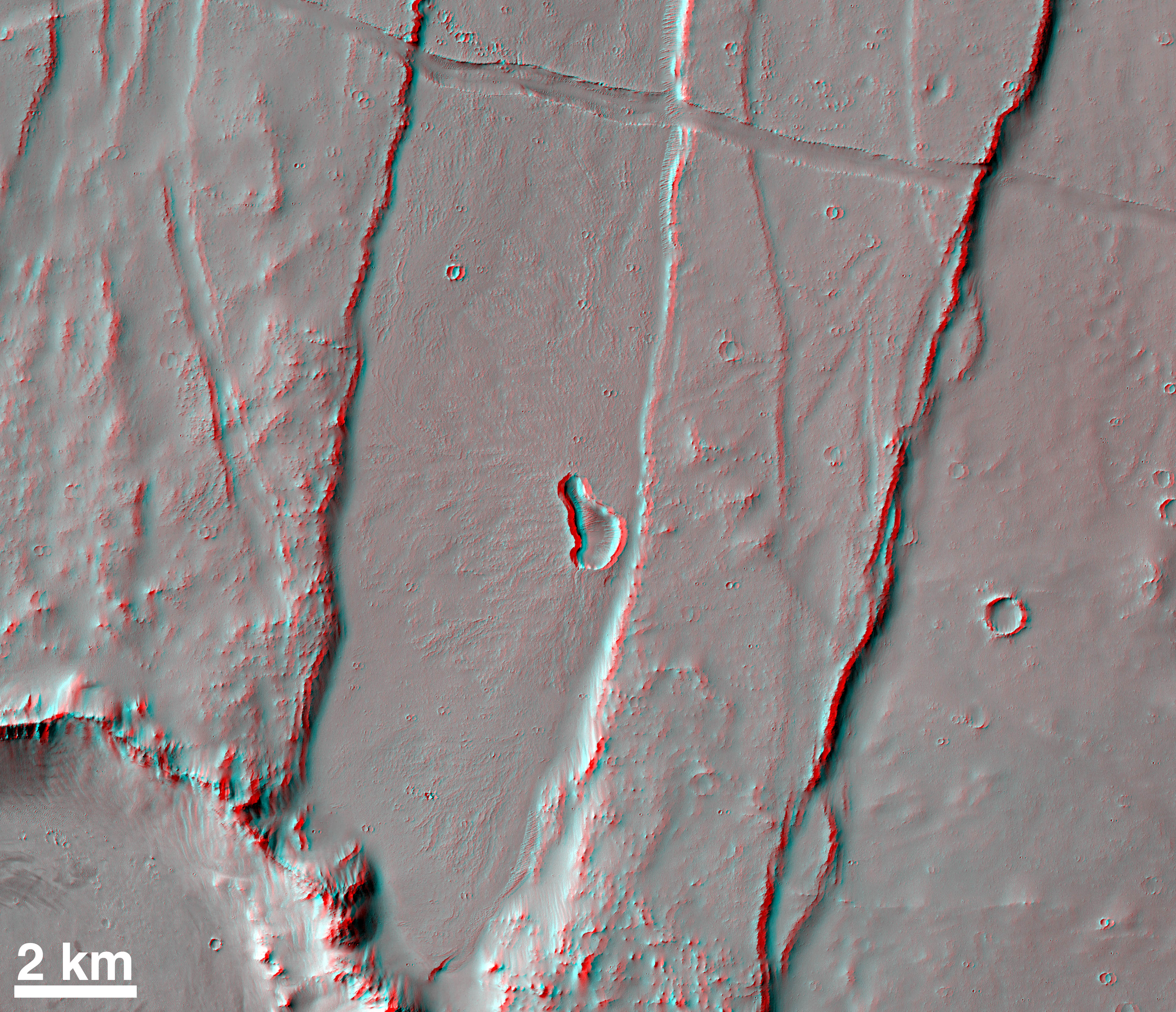
Small Volcano In Labyrinthus Noctis
Small volcanoes are common at the far west end of the Valles Marineris, as faults provided conduits for magma to reach the martian surface at some time in the past. Today, those volcanoes are covered with thick mantles of dust. The small volcano shown here is my favorite because it was one of the few in the region that had not been identified in images acquired by other orbiting instruments before CTX came along and happened upon it. This stereo anaglyph (red left eye, blue right eye) was prepared by Malin Space Science Systems personnel and is composed of sub-frames of CTX images P22_009738_1757_XI_04S104W and B01_010160_1757_XI_04S104W. The feature is located near 3.3°S, 104.7°W; north is up.
We also use CTX to suggest targets for the HiRISE and CRISM teams to image. Each science team selects targets for their instrument on a bi-weekly basis. When we are targeting CTX, sometimes we find that we're going to be able to image something that we think the HiRISE and/or the CRISM instruments should also look at. We target a CTX image to that location, and then we ask the HiRISE and CRISM teams to "ride along" with us so that there will be a nice set of simultaneous observations.
In addition to working with the other instruments on MRO to ensure an exciting and high quality data set, we also are using CTX to investigate Mars in a more general sense. We have made 6 meter per pixel mosaics of huge regions, including both residual polar caps and most of the Valles Marineris (we're still trying to finish that one!). We are also monitoring many regions to look for changes -- new impact craters, changes in mid-latitude gullies, dust devil and wind streaks, defrosting of the seasonal polar caps, and so forth. In addition, we like taking stereo pair images, as you can see from the anaglyphs presented with this article. :-)
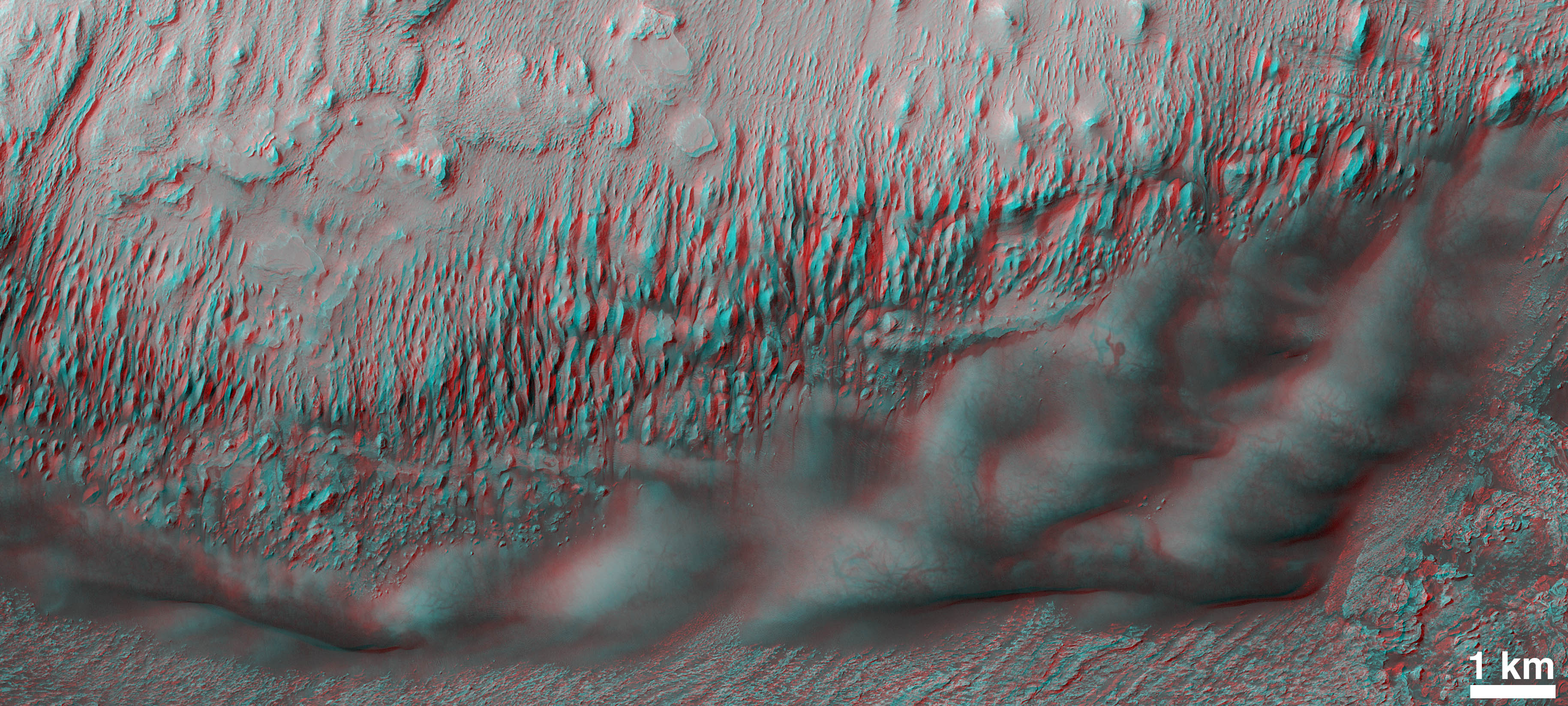
Sand Dunes in Western Arabia Terra
This CTX stereo anaglyph (red left eye, blue right eye) shows dark sand dunes at the base of a mound of wind-eroded, layered rock in an unnamed crater in western Arabia Terra. The dunes, which are composed of dark sand grains, have a thin coating of lighter-toned dust on their surfaces. The presence of a dust coating suggests that the dunes have not been very active in a while, because when wind blows sand, it also removes dust. The coating of dust has, however, has been changed by the passing of occasional dust devils. Dust devils left dark streaks and squiggles on the dune surfaces. Some of those streaks appeared during the 1-month interval between the acquisition of the two images in the stereopair -- those new streaks only appear in one of the two pairs (blink one eye closed, then the other, while viewing with 3-d glasses, to see the difference). The anaglyph was prepared by Malin Space Science Systems personnel and is composed of sub-frames of CTX images P19_008416_1827_XN_02N009W (13 May 2008) and P20_008772_1829_XN_02N009W (10 June 2008). The feature is located near 2.4°N, 9.4°W; north is up.Everything we do is geared toward testing some scientific hypothesis. Every time we find something new and interesting, we ask ourselves what other images can we obtain to help test our ideas about that thing? Some of these efforts take a long time
Protect Our Shared Future
You help us defend humanity and prevent asteroid impacts. Donate now to become a Planetary Defender!
Donate