
 Explore Worlds
 Find Life
 Defend Earth


Curiosity update, sols 1073-1107: Driving toward dunes, distracted by haloes
Written by
Emily Lakdawalla
September 18, 2015
Since I last checked in with Curiosity, the rover has been steadily driving southward, heading fairly directly toward the Bagnold dune field. When Curiosity left Marias Pass on sol 1072, they had one piece of unfinished business: drilling into the aeolian sandstone of the Stimson unit that tops the lake-laid mudstone of the Murray formation. Since Stimson sandstone forms exposed bedrock everywhere that Curiosity planned to drive over the next several hundred meters, they figured it wouldn't be very hard to find a good spot to drill. But as they have driven along, they've driven into puzzles, making it harder than anticipated to select the right spot where drilling can answer their questions.
So the story this month has mostly been one of driving. Now on top of the Stimson unit, Curiosity's path is taking her across a rhythmic set of ridges, each roughly a meter high and spaced 20-30 meters apart, that earned this terrain the nickname "washboard unit" when seen from orbit. Here is a 3D look at the recent traverse map, which makes that topography very clear.
This unit makes for challenging driving for a number of reasons. Have a look at the view forward on sol 1083:

I have personally been apprehensive about this stage of Curiosity's mission ever since writing my long explainer on Curiosity's wheel damage more than a year ago. The terrain that Curiosity is driving on now was identified from orbital missions as being of the potentially wheel-shredding variety. So I have been examining wheel images very closely and I'm pleased to report that, at least to my eye, there is no acceleration in wheel damage now that Curiosity is driving on a rock-capped plateau.

Comparing wheel images taken on sols 708, 962, and 1046, there are only slight changes, and I see no grousers (treads) in trouble. This composite looks at Curiosity's most-damaged wheel, the left-middle one.

That being said, there has been no full-wheel imaging set in the last 450 meters, which includes most of the Stimson driving, so I'll still be examining the next full set of wheel images closely. (They usually perform a full set of wheel images once every 500 meters.)
Another reason the driving is difficult is because the rhythmic ridges that make up the "washboard" limit the rover planners' forward view of the terrain to a few tens of meters. Even if it weren't for the limited viewsheds, in this potentially wheel-shredding terrain, they want to be able to see and steer around every rock. So each drive day has been taking them only 10 to 40 meters or so southward. Still, progress is progress, and they're making it, drive sol by drive sol.

As they work southward, they're looking for a good drill site. But, project scientist Ashwin Vasavada told me, they've been distracted by a new feature type that they haven't seen before. Whereas the Murray formation mudstone had very thin, very distinct fractures filled with bright calcium sulfate veins, the Stimson unit has something different. Here's a reminder of what the Murray formation veins look like:

The Stimson unit also has fractures, but they are spaced much wider apart. They also don't seem to have those distinct calcium sulfate fills. The weirdest thing about them is that they are surrounded by bright haloes that spread into the Stimson rock itself, and they mark zones where the Stimson unit erodes more easily than elsewhere. Here are a few snapshots of these haloes along Curiosity's recent trek:

What are these haloes? Is it a deposit of mineral material in the pores of the Stimson unit? Is it a place where the Stimson has been bleached? Has something been leached away? Or is it just a zone where one mineral has been altered into another? So far, Ashwin says, there are a lot more questions than there are answers.
So they are looking for a good place to drill, but one of their challenges is that they want to find a location where the stratigraphic relationship between the underlying Murray formation and the overlying Stimson unit is clear. That way, they'll know where in the Stimson unit they're drilling. It's not been easy to find such a location that is also good for drilling. As of sol 1106 they had a decent view of the contact, and were trying to identify a good place to drill along the path south. So my next report in a few weeks will hopefully concern drilling into the Stimson. Perhaps they'll even find a location where they can drill into one of those haloes.

I thought this would be a good time to zoom out and take stock of Curiosity's traverse to date. I made a new overview map, showing the entire route. I've called out the drill locations in white dots and bold text. You can see how the amount of drilling activity has dramatically increased since their announced arrival at the base of Mount Sharp around sol 740.

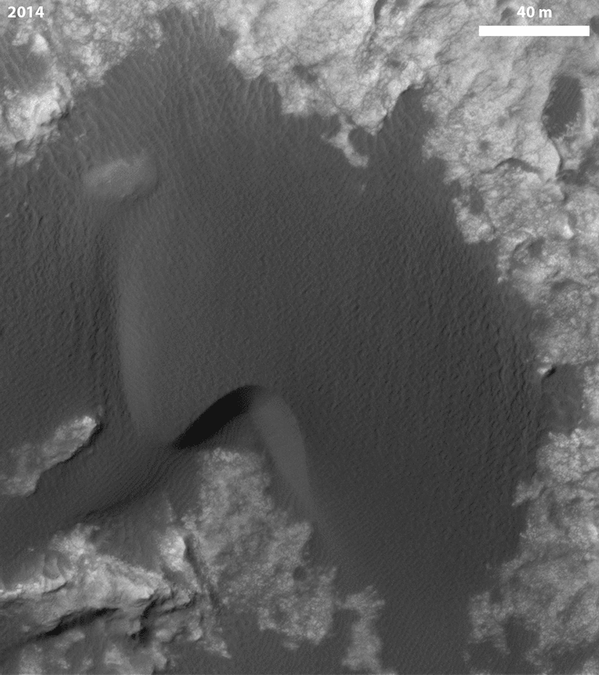
Once they have drilled the Stimson, the next stop is the dunefield, Ashwin told me. This is rather exciting because the very first dune that Curiosity will encounter is one that has actually been observed to move over time. Here is a comparison of two images taken by HiRISE in 2008 and 2014. The ripples on top of the dune are moving from north to south, and the dune itself is also moving southward, more slowly. This will be the first time that a Mars rover has visited a dune that is known to be active. (I'll let Lori Fenton explain the difference between dunes and ripples to you.)
After encountering this dune, Curiosity will skirt the dune field on a westward path, driving up and over another segment of washboard-like Stimson unit. Then the rover will drop down again, finally beginning to cross the dune field from north to south across a relatively sand-free area between the Murray buttes and the dunes. The dunes and the buttes are going to make for some dramatic views ahead.
To whet your appetite, here is another 3D HiRISE image that covers the area of the dune field that Curiosity has to cross. It's an area where the sand is thin, exposing bedrock; hopefully the traverse will not be too hard.
And finally, here's a Mastcam view of the path ahead. It's quite a lovely place to be.

As usual, here are the detailed updates from the USGS Astrogeology Blog covering this period.
Sols 1075-1077 update by Ryan Anderson: Time for SAM! (14 August 2015)
We had another successful drive on sol 1074, putting us in a good position for the weekend! The main activity for the weekend is using the Sample Analysis at Mars (SAM) instrument to analyze some of the recent drill sample that we collected. SAM activities will take up all of sol 1075. On sol 1076, we will use MAHLI to check on the health of our wheels, and SAM will do its Evolved Gas Analysis (EGA) measurement on the sample.
On sol 1077 we have lots of ChemCam and Mastcam activities. Mastcam has a 20x2 mosaic of an area called “Fournier”, followed by ChemCam observations of the targets “Butler”, “Evaro”, “Coldwater”, and “Alberton” and associated Mastcam documentation images. Navcam also has an atmosphere monitoring observation of the horizon to the north.
Later in the afternoon on sol 1077, ChemCam has a calibration observation and Mastcam has another observation of “Alberton” to try to see textures highlighted by the lower sun angle. Navcam also has a couple more observations, watching for clouds and dust devils.
Sols 1078-1079 update by Ken Herkenhoff: Back to restricted planning (17 August 2015)
I had an easy planning day as MAHLI/MARDI uplink lead today, because another drive is planned for Sol 1078 with only the usual post-drive MAHLI (stowed) and MARDI (twilight) imaging. Planning is restricted again (Mars and Earth time are out of sync), so we are planning two sols. Before driving away from the current location, ChemCam and Mastcam will observe rock targets dubbed "Huson" and "Ignatius" and Mastcam will image another rock called "Hodown." After the drive, an overnight CheMin integration on the drill sample is planned, followed by atmospheric observations early on the morning of Sol 1079. More Navcam atmospheric observations are planned later that sol, along with some ChemCam calibration activities. I'm glad that we are making good progress toward Mt. Sharp!
Sols 1080-1081 update from Ryan Anderson: Official New Selfie! (19 August 2015)
We had another successful drive on 1079, going about 29 meters this time. The plan for sols 1080-1081 is pretty similar to the previous plan: remote sensing and a drive on the first day, and untargeted science on the second day. On sol 1080, ChemCam has observations of the targets “Red Lodge”, “Mowry”, and “Rosebud”, with accompanying Mastcam images. Mastcam will also take a 19-frame stereo mosaic of a cliff dubbed “Judith River”. After the drive, we have our standard post-drive imaging, plus an active measurement with DAN.
On sol 1081, since we won’t have the data down yet to do targeted observations, we have a bunch of atmospheric monitoring with REMS, Navcam, Mastcam, and ChemCam. We’re also planning a 360 degree Mastcam mosaic to take in our new surroundings and MARDI will take a picture of the ground under the rover.
Meanwhile, here on Earth, NASA has released the "official" versions of the low-angle selfies taken by MAHLI while we were drilling at "Buckskin". I don't know about you, but I have a new wallpaper image!
Sols 1082-1084 Update from Ken Herkenhoff: Nice view (21 August 2015)
I'm having another very busy day as SOWG Chair, as we are planning lots of activities to keep the rover busy this weekend. The vehicle is on a local high spot that gives us a spectacular view of the terrain ahead. But there aren't many targets in front of the rover that are suitable for contact science, so we selected only one (called "Ravalli") to investigate using MAHLI and APXS. We had time for another contact science target, but decided that it would not be worthwhile to study the smaller rocks that are within arm's reach.
On Sol 1082, ChemCam and Mastcam will observe Ravalli and a brighter rock dubbed "Sawtooth" before Mastcam acquires a 23x6 mosaic of the nice outcrops ahead. Mastcam and Navcam will look up at the sky at about the same time that the Mars Odyssey orbiter will be passing over, to compare results of observations from above and the surface. Then the arm will be deployed for contact science and the APXS placed on Ravalli for overnight integration.
ChemCam and Mastcam will observe a couple more bright blocks on Sol 1083, named "Stonewall" and "Wolsey," before the rover drives toward the south. We'll then acquire the usual post-drive images and DAN active data. On the last sol (1084), ChemCam will take some calibration data and SAM will clean its scrubber in preparation for future measurement.
Sols 1085-1086 update by Ken Herkenhoff: Rough road ahead (24 August 2015)
MSL had a good weekend, and returned lots of data including nice MAHLI images of Ravalli. The nearly 22-meter Sol 1083 drive completed as planned, and placed the rover near some nice rock outcrops. I helped the planning team select targets for ChemCam observations; we settled on two that were named "Tinder Box" and "Gordon." Mastcam will acquire mosaics of these targets as well as "Centennial Range" and "Willow Ridge." There isn't time/power for much more science, as another drive is planned for Sol 1085 and an overnight SAM atmospheric observation. ChemCam, Mastcam and Navcam will make more atmospheric observations late in the morning of Sol 1086, along with the usual REMS background measurements. The path ahead is rough but looks very interesting!
Sols 1087-1088 update by Ken Herkenhoff: Bright features (26 August 2015)
The complex, nearly 39-meter Sol 1085 drive completed successfully, leaving the rover in another target-rich area. Again, I helped pick targets for ChemCam observations--our favorites were on the brighter parts of the outcrop just south of the rover. The targets for ChemCam and Mastcam observations were named "Fitzpatrick," "Keith," and "Fred and George Creek." Mastcam will also acquire 2 mosaics before the rover drives away on Sol 1087. Planning is still restricted, so we also planned Sol 1088, which starts with early-morning Mastcam and Navcam images of the sun and sky. Similar observations are planned around noon that sol, to measure daily variations in atmospheric dust and clouds. Finally, CheMin's inlet funnel will be vibrated in an attempt to remove a particle from the screen over the funnel.
Sols 1089-1090 update by Lauren Edgar: Stimson is Stunning (28 August 2015)
Curiosity is currently making her way through some beautiful exposures of the Stimson unit. The 6 m drive on Sol 1087 went well, and Curiosity is in a good position for possible contact science early next week.
Today we’re planning 2-sols for the weekend (Sunday is a “soliday” to allow Earth and Mars schedules to sync back up). One of the main activities on Sol 1089 is dropping off part of the Buckskin drill sample to SAM. Then we’ll dump the Buckskin post-sieve sample, and analyze it with APXS. The plan also includes Mastcam and MAHLI imaging to document the dump pile. Sol 1090 consists of several ChemCam observations of the targets “Fox Hills,” “OBriens Creek,” and “Bearpaw” to investigate the bedrock and local alteration features. We’ll also acquire a large Mastcam mosaic to document the stratigraphy, and a Navcam deck pan for dust monitoring. This region has some particularly stunning views, so I’m looking forward to seeing the new mosaics!
Sol 1091 update by Ken Herkenhoff: Lots of MAHLI targets (31 August 2015)
Planning is no longer restricted, but we had to start at 6:00 PDT this morning to give the operations team enough time to uplink commands by the time the rover expects them. Driving to work before sunrise reminded me of the sometimes odd times we had to wake up during the first 90 sols of the mission, when the entire operations team was on "Mars time."
The team is very interested in the outcrop in front of the rover, so I had a very busy day as MAHLI/MARDI uplink lead today, even though we are planning just one sol. We planned in advance for MAHLI nighttime imaging of CheMin's inlet and MAHLI's calibration target (using white and UV LEDs), so those activities were ready to go this morning. But we had to prioritize and plan the details of observations of other contact science targets. Because the Sol 1089 MAHLI images and APXS placement were not perfectly centered on the Buckskin dump pile, our top priority is to repeat those observations with updated positioning. We planned MAHLI images of a target dubbed "Devon," which will also be measured by APXS. Many of the targets of interest are difficult to reach with the arm, so the rover planners requested relatively low-resolution MAHLI images of them to support planning of more contact science on Sol 1092. These targets were named "Pentagon," "Lebo," "Ivanhoe," and "Ledger," with Ledger being imaged in stereo by Mastcam because it is a candidate for brushing with the DRT. Finally, the APXS will be placed on the dump pile for overnight integration.We had to put more thought than usual into prioritizing various data for downlink, as we expect only 38 Mbits of data before Sol 1092 planning begins tomorrow morning. This situation forced us to compress some of the MAHLI images more than usual, and to create new command sequences. But if all goes well, we will receive enough data tomorrow morning to plan contact science on multiple targets.
Sol 1092 update by Lauren Edgar: Stimson Contact Science (1 September 2015)
Curiosity is currently investigating an outcrop of the Stimson unit. On Sol 1091, Curiosity acquired some low-resolution MAHLI images of the targets “Pentagon,” “Lebo,” “Ivanhoe,” and “Ledger” in order to plan more detailed imaging of those targets today.
The Sol 1092 plan includes targeted remote sensing followed by more contact science. In the midday science block, we’ll acquire ChemCam and Mastcam on the targets “Rabbit Hills” and “Horseshoe Hills” to investigate some of the alteration features seen here. We’ll also acquire some large Mastcam mosaics of the “Williams” area to investigate the sedimentary structures. The plan also includes a ChemCam RMI autofocus test, and a Navcam movie to monitor the atmosphere. In the afternoon, we’ll acquire closer MAHLI imaging on “Lebo,” “Ivanhoe,” and “Ledger,” using the information we gained from the Sol 1091 MAHLI finder frames. Since "Ledger” is a nice flat ledge, it’s also a good target for the DRT, so we can brush away the dust to expose a fresh surface. Then we’ll place the APXS on “Ledger” for an overnight integration. We’re in really early slide sols this week (meaning planning starts at 6am), but that hasn’t stopped the team from putting together some very full plans!
Sol 1093 update by Lauren Edgar: Leaving the Williams area (2 September 2015)
After successful contact science on the Stimson unit in the Williams area, it’s time to get back on the road. In today’s plan we’ll finish up a few activities at the Williams area, and then continue on our drive towards Bridger Basin and eventually the Bagnold Dunes.
Today’s plan consists of ChemCam and Mastcam observations on the targets “Interlake,” “Ledger,” and “Mackay Dome.” Then we’ll image the “Ledger” target using all of the Mastcam camera filters, and take another Mastcam clast survey image to look for any changes in the time that we’ve been here. We’ll also use Mastcam to look at the sun to measure the atmospheric opacity. Then we’ll take a short drive and acquire post-drive imaging to help with targeting in tomorrow’s plan. It’s exciting to be driving again, and I’m sure we’ll encounter some beautiful views as we continue to drive through this interesting terrain.
Sol 1094 update by Lauren Edgar: Turning in to Bridger Basin (3 September 2015)
The drive on Sol 1093 went well, and Curiosity drove ~15 m towards Bridger Basin. In the Sol 1094 plan, we’ll drive for ~30 m to round the turn into the basin, as we continue making our way through the Stimson unit. These rocks exhibit a lot of beautiful cross-bedding, as seen in the Sol 1093 Navcams.
Today’s plan consists of ChemCam and Mastcam observations on the targets “Whitewater” and “Whitefish,” two targets that are within a bright, bleached area near a fracture. After a short drive, we’ll take standard post-drive imaging to help with targeting in tomorrow’s plan. The plan also includes a ChemCam RMI autofocus test to assess temperature effects. Looking ahead, tomorrow will be a busy 4-sol plan to prepare for the long weekend!
Sols 1095-1098 update by Lauren Edgar: Laboring away in the Stimson… (4 September 2015)
As many of us in the U.S. take a break over Labor Day weekend, Curiosity will be keeping busy by using every instrument in her science payload! Curiosity is currently making her way towards Bridger Basin and studying the Stimson unit along the way.
The weekend 4-sol plan is packed with exciting science. On Sol 1095, we’ll acquire ChemCam and Mastcam on the targets “Bullwacker,” “Damnation,” and "Bootlegger,” to assess the chemistry of some of the bright bands along fractures and unaltered bedrock. We’ll also take some Mastcam mosaics to investigate the local geology. In the evening, SAM will run a diagnostic test, and CheMin will dump the Buckskin sample and analyze an empty cell to prepare for analysis of a future drill sample. On Sol 1096, Curiosity will take it easy, and the science activities mostly just involve standard RAD and REMS observations. Things pick up again on Sol 1097, with another science block full of ChemCam and Mastcam on “Hell_Creek,” and “Sober_Up_Creek” (yes, these are real names of features near Arlee, Montana!) and additional Mastcam mosaics to investigate the stratigraphy and sedimentary structures. Then we’ll use MAHLI to check out the REMS UV sensor, followed by MAHLI on the target “Conniption,” as well as several DAN Passive observations. Overnight, Curiosity will acquire APXS on “Conniption.” On Sol 1098, Curiosity will drive for ~35 m, followed by post-drive imaging to prepare for targeting next week, and an evening MARDI image to assess the ground beneath the rover. Finally, on the morning of Sol 1099, Curiosity will take several Mastcam and Navcam observations to monitor the atmosphere. Phew!
Sol 1099 update by Ken Herkenhoff: Driving again (8 September 2015)
MSL did well over the long weekend, except that the Sol 1098 drive was halted after 13 meters of the planned 25 meters because the rover could not confirm that the path ahead was safe. So the plan for the Sol 1099 drive is essentially to complete the rest of the previously planned drive. The only significant problem I've had to grapple with today as SOWG Chair is that the last 5 relays of data through MRO have returned significantly less data than expected; if this problem continues, we will barely receive enough data to plan another drive on Sol 1100. Fortunately, the MRO team understands the problem and knows how to correct it, and there is a good chance that we will receive all the data we need in time for planning tomorrow morning. This situation reminds me of how much we depend on the Mars orbiters and the teams that operate them, and to thank them for their continued support of the MSL mission.
Before the Sol 1099 drive, we have time to acquire ChemCam and Mastcam observations of "Mission Creek" and "Chamberlain," plus MastCam mosaics of "Bridger Basin," "Hackley Point," and "Police Creek." The rover will wake up early on the morning of Sol 1100 to acquire a big stereo mosaic of the far wall of Bridger Basin, because the illumination will be better early in the morning. Mastcam will also take a 360-degree panorama with the left camera.
Sol 1100 update from Ken Herkenhoff: Swan, Sunburst, Studhorse, Sweetgrass Arch, and Silver Hill (9 September 2015)
The rover drove 34.5 meters on Sol 1099, as planned, to a good location for the imaging of the northwest wall of Bridger Basin. The Mastcam team verified that the pointing of the mosaic of that wall, planned to occur early on Sol 1100, is excellent. So the Sol 1100 plan includes another drive, to the southwest edge of the small plateau the rover is on. Before the drive, ChemCam and Mastcam will observe nearby layered rocks dubbed "Swan" and "Sunburst," and Right Mastcam mosaics will be taken of targets named "Studhorse," "Sweetgrass Arch" and "Silver Hill." After the drive, in addition to the standard post-driving activities, we're planning a Right Mastcam mosaic of "Beartooth Butte" and a SAM diagnostic activity in preparation for the next solid sample analysis. Fitting all of the desired observations into the plan was challenging, otherwise I've had an easy day as SOWG Chair.
The MRO operations team identified the cause of the communications relay problem we had over the holiday weekend, and sent commands to the spacecraft to correct it. We're happy that we are again receiving lots of good data via MRO!
Sol 1101 update from Ken Herkenhoff: Driving into the Saddle (10 September 2015)
The 34-meter drive planned for Sol 1100 placed the rover at the edge of the small plateau, as intended, with a good view of a bright Murray Formation outcrop. The center of the Murray outcrop is the target of the drive planned for Sol 1101, which will hopefully put the vehicle in position for contact science over the weekend. Before the drive, ChemCam RMI and Mastcam observations of targets named "Brady" and "Bradley" are planned, both of which are on the far wall of Bridger Basin. Mastcam will also observe a shallow trough in the soil next to the rover ("Blackleaf Creek") and acquire a mosaic of the Murray exposure, which has been named "Saddle."
Although MRO is now relaying data as expected, it will pass low in the sky over MSL after the Sol 1101 drive, so we aren't expecting to receive as much data as usual. The biggest challenge for me as SOWG Chair today was therefore planning and prioritizing the data we need for planning tomorrow. We're hoping that we get at least as much data as expected.
Sols 1102-1104 update by Ken Herkenhoff: Arm error recovery (11 September 2015)
The Sol 1101 activities that we planned yesterday did not complete due to an arm error while it was being stowed. Apparently the shoulder azimuth motor was too cold, so the rover software halted the stow, which precluded the drive that was to follow. The rover is therefore in the same position that it was yesterday.
I'm not scheduled in any operational role today, but I called in to help plan MAHLI imaging of the ChemCam optical window, to monitor dust accumulation. The operations team had to scramble to recover from the arm error and plan science observations, but was able to put together an excellent weekend plan. On Sol 1102, MAHLI will take the standard images of the rover wheels, then acquire a full suite of images of a rock dubbed "Badlands." APXS will then be placed on the rock for an overnight integration. Arm work will continue on Sol 1103, with MAHLI images of the ChemCam window. Then ChemCam and Mastcam will observe targets named "Madison" and "Jefferson." On Sol 1104, the RMI and Mastcam will take images of a bright ridge on the flank of Mt. Sharp, then ChemCam and Mastcam will observe "Lincoln." Mastcam will also acquire another mosaic of the wall of Bridger Basin, then the rover will drive to the bright Murray outcrop "Saddle" as planned yesterday. Fortunately, the Sol 1104 orbiter overflight geometry is better than it was yesterday, so we expect to receive all the data needed for planning on Monday. Finally, early on Sol 1105, Mastcam and Navcam will observe the sun and sky soon after the Mars Odyssey orbiter flies over, so that orbiter observations can be compared with nearly simultaneous observations from the surface. Overall, not a bad plan, considering that the operations team had to quickly respond to the arm error!Sol 1105 update by Lauren Edgar: Murray Formation Contact Science (14 September 2015)
Over the weekend, Curiosity had a successful ~ 21 m drive, and we’re currently parked in front of a beautiful outcrop of the Murray formation (shown in the bottom half of the above Navcam image, overlain by Stimson). We’ve mostly been driving through the Stimson unit for the past 280 m, so this is a great opportunity to do contact science on the Murray formation to look for any changes in composition or grain size.
I was the Geology Theme Lead today, and our plan consists of 1.5 hours of targeted remote science, followed by contact science. We planned several ChemCam and Mastcam observations on the targets “Winnipeg,” “Alma,” and “Blackjack.” “Winnipeg” is a target in the Murray formation that we’ll also assess with MAHLI and APXS. “Alma” is aimed at characterizing the composition across the Murray-Stimson contact, and “Blackjack” is a resistant ledge within the Murray formation. We’ll also acquire a couple of Mastcam mosaics to document the Murray-Stimson contact and characterize the local structure and stratification, and a Mastcam tau to assess atmospheric opacity. In the afternoon we’ll acquire several MAHLI images of the “Sacajawea” target to investigate a resistant ledge. Then we’ll use the DRT to brush off the dust on “Winnipeg” and take some really close MAHLI images to look for grain size variations. Overnight, we’ll use APXS to investigate the composition of the “Winnipeg” target.
Sol 1106 update by Lauren Edgar: Searching for the Next Drilling Location (15 September 2015)
After some additional contact science on the Murray formation (of the location shown in the above Mastcam image), we’re now in search of a good sandstone for our next drill target.
The goal of today’s plan is to drive towards a bright patch of blocky outcrop that was first identified in orbital images, and to see if this outcrop is an area that we might want to investigate further. Today’s plan includes an hour of targeted science, followed by a short drive towards the bright outcrop, and post-drive imaging for targeting.
In the morning science block, we’ll acquire ChemCam and Mastcam observations of the targets “Prichard” and “Cat Creek” to look for changes in composition through the Murray formation. We also planned a Mastcam mosaic of the “Vaughn” area to document the Murray-Stimson contact. Then we’ll acquire a Mastcam mosaic of the “Rice” area to investigate the bright patch from our current location. After a short ~12 m drive, we’ll acquire standard post-drive imaging, as well as another large Mastcam mosaic of the “Rice” area. As the Geology Theme Lead today, I had to balance downlink priorities to make sure that we’ll get all of the necessary imaging down in time to make a decision tomorrow (is this a good place to investigate further? Or should we keep driving?). Can’t wait to see what the new images will reveal!
Sol 1108 update by Ken Herkenhoff: Limited data for planning (17 September 2015)
The 16.6-meter drive planned for Sol 1107 completed as planned, placing the rover in front of the bright outcrop of interest. As expected, only a few post-drive images were received in time for Sol 1108 planning, which made it more difficult than usual to pick targets for remote sensing observations and driving. However, we found some bright blocks that the Rover Planners confirmed would be good targets for contact science, and plan is to approach and study them this weekend. But first ChemCam and Mastcam will observe nearby rock and soil targets named "Sphinx," "Houle," and "Utopia." After the short drive, we decided not to acquire the usual MAHLI stowed image and MARDI twilight image, as the view from MAHLI will not be
very different than the previous image, and we can't acquire the MARDI image when we would like because there will be a Mars Odyssey communications session at that time. We can acquire these images on Sol 1109 anyway. So it was an easy day for me as MAHLI/MARDI uplink lead today, and I helped pick ChemCam/Mastcam targets.
Protect Our Shared Future
You help us defend humanity and prevent asteroid impacts. Donate now to become a Planetary Defender!
Donate