
 Explore Worlds
 Find Life
 Defend Earth


Curiosity update, sols 782-813: Walking the outcrop at Pahrump Hills
Written by
Emily Lakdawalla
November 19, 2014
It's been quite a while since I've written a Curiosity update -- Philae's landing has kept me insanely busy. But actually Curiosity hasn't moved very far since the last time I checked in on her. Still, she's been plenty active. At Pahrump Hills, Curiosity is becoming the field geologist she was intended to be.
Pahrump Hills is a light-toned outcrop of rock, easily visible from orbit, that represents about seven meters of layered sedimentary rocks, thought to be the bottom-most visible layers of Mount Sharp. Here is a wide view of the Pahrump Hills outcrop, taken as Curiosity approached it two months ago:

In the last month, Curiosity has "walked the outcrop," crawling up and down the length of it, giving it a once-over:

Now she's in the middle of a second tour, retracing her steps, putting her eyeball close to the outcrop (with the MAHLI Hand Lens Imager) and checking elemental composition with the Alpha Particle X-Ray Spectrometer. If her science team back on Earth likes what they see, they may send her on a third walkabout, targeted at one or more spots to tap at them with her rock hammer (er, I mean, drill them with her drill) and collect a sample or two.
One spot she's giving a close second look is Pink Cliffs, shown here from a distance:

Here are two very interesting spots at Pink Cliffs that Curiosity has re-examined up close. I've never seen anything at the Curiosity landing site quite like these lens-shaped crystals. They're quite different from the blockier plagioclase feldspar laths we've seen in volcanic rocks elsewhere in Gale crater. I'm dying to know what their chemistry is, and what that chemistry means for the watery history of this rock.

And what are these rosette things? They're smaller than they look, only about a centimeter across.

And that's just a small taste. Pahrump Hills is really the first place Curiosity has been where the science team has been free to approach a field site in the way a human field geologist might do back on Earth. There have only been two other spots that Curiosity has examined in as much detail: Yellowknife Bay, and the Kimberley. But Yellowknife Bay was during the shakedown portion of the mission, when many of the activities were strongly driven by engineering considerations; the science team hadn't been handed the keys to the rover yet. And at the Kimberley, the mission was in the middle of dealing with the unexpected wheel damage, so the team's ability to drive was limited, while at the same time there was tremendous time pressure to get back on the road to Mount Sharp.
But now it's the extended mission, and Curiosity has reached the base of Mount Sharp, and things have changed. Of course Curiosity's actions are still limited by what is safe for the rover to do -- that's true of any space mission, ever. But the time pressure is drastically reduced and there's no question that this is exactly the kind of field site that Curiosity is supposed to be spending her time and resources exploring. I have it on good authority that the science team is enjoying this!
There is one worrying issue, explained in a recent Web update on the Curiosity mission. The ChemCam instrument -- which Curiosity relies upon for remote sensing of spots with interesting elemental compositions -- may have lost the small continuous-wave laser that it uses for autofocus of the more powerful plasma-making ChemCam laser beam.
Diagnostic data from ChemCam suggest weakening of the instrument's smaller laser. This is a continuous wave laser used for focusing the telescope before the more powerful laser is fired. The main laser induces a spark on the target it hits; light from the spark is received though the telescope and analyzed with spectrometers to identify chemical elements in the target. If the smaller laser has become too weak to continue using, the ChemCam team plans to test an alternative method: firing a few shots from the main laser while focusing the telescope, before performing the analysis. This would take advantage of more than 2,000 autofocus sequences ChemCam has completed on Mars, providing calibration points for the new procedure.
It's a relief to know they have a workaround, but it'll take a little time to develop with the test unit on Earth before they can upload a software patch to Curiosity. In the meantime, they might try a more kludge-y focus method: just try doing ChemCam analyses with focus manually set at a small number of slightly different distances, figure out which one worked best, and downlink only that data. It's inconvenient but not a showstopper; it does serve as a reminder that Curiosity is beyond her one-Mars-year warranty, and we can expect equipment failures from time to time. I will admit to being a little surprised that ChemCam was the first instrument to have a problem. The DAN instrument is actually already operating well beyond the time that its neutron generator is supposed to be able to generate neutrons -- I expect to hear of that one failing any day. (If it does fail, DAN will still function in a passive mode, even if it can't generate neutrons anymore.)
To balance the ChemCam problem, there's a piece of good news. The radio link between Curiosity and MAVEN was tested for the first time on November 6, and Curiosity transmitted a highly respectable 550 Megabits of data through MAVEN. It's only a matter of time until we lose one or both of the aging orbital relay missions that Curiosity relies upon for data relay at present -- Mars Odyssey and Mars Reconnaissance Orbiter are both way past their warranty periods. Neither shows any sign of imminent failure, but it's a relief to know a new orbiter is in place and capable of serving should one or the other of the old orbiters go the way of Mars Global Surveyor. However, MAVEN will never be as perfect a radio relay as Odyssey or MRO, because the older orbiters have sun-synchronous orbits so pass over the Curiosity landing site at reliably repeatable times of day, once every afternoon and once in the wee hours of the morning. By contrast, MAVEN's orbit has it showing up over Curiosity's landing site at much less regular times. But that's a scheduling problem that the Curiosity team will be able to deal with when the time comes.
I'm sorry that I don't have time to write a more detailed update; I include below the updates from the United States Geologic Survey scientists who are keeping up the Astrogeology blog.
Sol 782-784 Update from Ken Herkenhoff: Comet Observations (17 October 2014)
The experience I gained planning the MARDI drive "video" for Sol 780 helped me prepare for another MARDI video during the Sol 782 drive. I'm MAHLI/MARDI uplink lead again today, and got a good start on the video and post-drive MAHLI/MARDI observation planning. But concerns were raised about the safety of Sol 783 ChemCam observations of Comet Siding Spring after the Sol 782 drive, so the drive was deleted from the plan along with the associated MARDI and MAHLI imaging. While I was disappointed by this change of plans, I recognized the importance of the comet observations. Comet Siding Spring will be closer to Mars this weekend than any comet has approached Earth in historic times, and all the spacecraft at Mars will be observing this rare event. I look forward to seeing the results!
Sols 785-786 Update from Lauren Edgar: Comet Siding Spring (20 October 2014)
Over the weekend, a number of Mars spacecraft observed a rare encounter with comet Siding Spring. Curiosity successfully observed the comet with Mastcam, Navcam and ChemCam RMI. Today we’re planning two sols during which Curiosity will drive closer to the rock outcrop “Book Cliffs,” and perform some remote sensing. This is part of a bigger campaign to survey the Pahrump Hills. During the drive we will acquire a series of MARDI images to document the geology along the traverse. The plan also includes ChemCam observations of the targets “Ibex Pass,” “Hayden Peak,” and “Saddle Peak” with corresponding Mastcam images to characterize the local geology. After the drive we’ll acquire our standard post-drive imaging. The plan also includes several Navcam observations to monitor the atmosphere. I’ll be on duty as the Geology Science Theme Lead starting on Sol 787 so I’m getting up to speed on the current science plans and looking forward to exploring the Pahrump Hills!
Sols 787-788 Update from Lauren Edgar: Drive to Gilbert Peak (22 October 2014)
It was a busy day of rover operations here at the USGS. Ken Herkenhoff was the Science Operations Working Group (SOWG) Chair and I was the Geology Science Theme Lead (STL). Today we planned two sols and the goal was to characterize the Book Cliffs outcrop and drive toward the “Gilbert Peak” outcrop. This Navcam image from Sol 785 shows our current location at Book Cliffs in the lower right part of the frame, and some beautiful ripples in the valley to the west. The Sol 787-788 plan includes a number of ChemCam and Mastcam observations of the targets “Goblin Valley,” “Deadman Pass,” and “Funeral Peak” (we picked names that also fit a Halloween theme!). We also planned some Mastcam mosaics to investigate the stratigraphy at Book Cliffs and some other upcoming outcrops. During the drive on Sol 787 we will acquire a series of MARDI and Mastcam images to document the geology along the traverse. The plan also includes postdrive imaging to prepare for targeting on Friday, as well as environmental observations to characterize the atmospheric opacity and composition. Ken and I will both be on duty again on Friday, and we’re looking forward to exploring the Gilbert Peak outcrop.
Sols 789-791 Update from Lauren Edgar: Approaching Alexander Hills (24 October 2014)
It was another fun day of operations as we planned Curiosity’s continued investigation of the Pahrump Hills. Ken Herkenhoff was the SOWG Chair and I was the Geology STL. The drive on Sol 787 placed Curiosity approximately 18 m from the Gilbert Peak outcrop, and 8 m from what is now named the “Alexander Hills” outcrop. This Navcam image from Sol 787 shows the Alexander Hills as a small cliff in the middle of the frame, and the Gilbert Peak outcrop as the thin dark beds a little higher up on the hill. The goal in the 3-sol weekend plan is to characterize the outcrop in front of us and drive closer to the Alexander Hills. The plan includes several ChemCam observations of the rock targets “Skyline,” “Barstow,” and “San Gabriel.” Curiosity will also acquire several high-resolution Mastcam mosaics to characterize the local geology. After the drive we’ll acquire standard post-drive imaging to prepare for targeted observations on Sol 792. The plan also includes several Navcam observations to monitor atmospheric activity. Looking ahead to next week, we will continue working our way up the Pahrump Hills toward the Chinle outcrop (an outcrop to the west of Gilbert Peak).
Sol 792-793 Update from Ryan Anderson (27 October 2014)
I’ve been swamped with work for other projects recently, but those are behind me now, and I’m excited to get caught up on what Curiosity has been doing! The plan for Sol 792 has a nice big science block that we plan to fill with lots of targeted observations by ChemCam and Mastcam. ChemCam will analyze the target “Cajon” on the “Carnivore Canyon” outcrop and “Agate Hill” and “Aztec” targets on the “Alexander Hills” outcrop. ChemCam will also analyze the target “Crowder” right in front of the rover. Mastcam will take some supporting images of these targets, plus mosaics of “Zion Canyon”, “Tortoise Shell Mountain”, and a survey mosaic off the starboard side of the rover. Once all of the remote sensing is done, we are planning a drive toward the Chinle outcrop, during which MARDI will take time-lapse video of the terrain beneath the rover in order to create a continuous image strip along the path. The rover will also take some routine mid-drive and post-drive images. On Sol 793, ChemCam will make a passive observation of the sky and Navcam and Mastcam will also make some atmospheric observations.
Sol 794-795 Update from Ryan Anderson: Beautiful Layers (29 October 2014)
The 15.8 meter drive on Sol 792 was successful, bringing Curiosity right up to the Chinle outcrop, which has some beautiful layering. In the Sol 794 plan, we have ChemCam observations of four targets on the outcrop: “Cima,” “Sespe,” “Aguereberry Point,” and “Soledad Pass.” Mastcam will take a picture of Cima, and a high-resolution mosaic of Chinle. After that, Curiosity will drive toward “Whale Rock,” with the goal of getting in range so that ChemCam can zap it. During the drive we will again take MARDI images beneath the rover as it drives, as well as mid-drive and post-drive imaging with Mastcam and Navcam. On Sol 795, ChemCam and Mastcam will do some blind targeting and Navcam will search for dust devils.
Sol 796-798 Update from Ken Herkenhoff: Whale Rock (31 October 2014)
The 30-meter drive planned for Sol 794 completed perfectly, placing the rover near laminated blocks shed from the Whale Rock outcrop (visible at upper right in this image). So ChemCam and Mastcam will observe some of these blocks and the outcrop on Sol 796, before the rover drives away on Sol 797. I'm MAHLI/MARDI uplink lead again today, so I focused on planning MARDI imaging during and after the drive. The goal of the drive is the sandy ripples near the Confidence Hills drill site, where the physical and chemical properties of the ripples will be investigated.
Sol 799-800 Update from Ken Herkenhoff: Walkabout Completed (3 November 2014)
The initial reconnaissance of the Pahrump Hills outcrop is complete, and the 53-meter Sol 797 drive successfully placed the rover near the ripples of interest. So the Sol 799 plan includes a short drive into the ripples and "scuffing" of a 15-cm high ripple to examine its interior. Some of the Pahrump "walkabout" data have not yet been received from the rover, so we decided to limit the acquisition of new data on Sols 799 and 800 to allow more of the walkabout data to be returned. Before the Sol 799 drive and scuff, ChemCam and Mastcam will observe a bright outcrop named "Hackberry Spring." Then CheMin will add more mineralogical data for the Confidence Hill drill sample by integrating overnight and into Sol 800. I'm SOWG Chair today, and happy to see the prediction that the rest of the Pahrump walkabout data will be received by Sol 801.
Sol 801-802 Update from Ken Herkenhoff: Investigating the Scuff (5 November 2014)
The short drive and wheel scuffing activities planned for Sol 799 all completed as planned, leaving the rover in position for detailed examination of the scuff. Planning is still restricted, so we are planning 2 sols again today. On Sol 801, Mastcam and ChemCam will observe the material disturbed by the scuff, the "wall" of the scuff, and undisturbed material outside of the scuffed area for comparison. Then the APXS will be placed on the disturbed target "Kelso" for overnight integration. Much more arm work is planned for Sol 802: The APXS will be used to sense the surface, allowing more accurate placement of MAHLI near targets "Dumont," "Kelso," and "Garlock" for high-resolution imaging. Then the APXS will be placed on Dumont for another overnight integration. Planning all of these activities took more time than usual, so as SOWG Chair I had to watch the clock and push more than usual to get back on schedule. In the end, we recovered and the plan is looking good.
Sol 803-804 Update from Ken Herkenhoff: Shoemaker (7 November 2014)
I'm not on shift today, but keeping up with planning because I'm scheduled as SOWG Chair again on Monday. And of course I'm curious to see how Curiosity is doing! The arm activities planned for Sols 801 and 802 completed successfully, so this weekend the rover will drive toward the target "Shoemaker," named after the founder of the USGS Branch of Astrogeology, Eugene M. Shoemaker. But first, the arm will be stowed so that Mastcam can observe the Sol 802 contact science targets, and a full set of MAHLI images of the wheels will be acquired. Only two sols are being planned this weekend because Mars and Earth time are getting back in sync, completing the transition from restricted to nominal planning.
Sol 805 Update from Ken Herkenhoff: Tight Sol (10 November 2014)
MSL planning is no longer restricted, but today's commands must be sent to the spacecraft earlier than usual, so tactical planning started 1 hour earlier than usual. The Sol 803 drive put the rover in a good position for examination of fine-scale layering using the arm instruments. The science team proposed several arm activities on various targets, but time limitations required reducing the observations to APXS measurements and MAHLI imaging of two targets, "Ricardo" and "Pelona." The Dust Removal Tool will be used to brush dust off of the target Pelona before imaging it with MAHLI and placing the APXS on it for overnight integration. It was a hectic morning for me as SOWG Chair as we prioritized science targets and determined what could be included in the plan and reviewed before the deadline for uplink to the rover.
Sol 806-808 Update from Ryan Anderson: Congratulations Rosetta! (13 November 2014)
On Sol 806, we at the USGS were off for Veteran’s Day, but Curiosity was still busy! The sol 806 plan had a pretty simple morning science block with a single Mastcam image of the target “Glendora” along with some Mastcam and Navcam atmospheric observations. After that, we used the arm to take close-up images of targets “Ricardo” and “Pelona,” and to brush off Ricardo in preparation for an overnight measurement of its composition using APXS. The afternoon science block was dedicated to some more atmospheric observations.
On sol 807, we did some Navcam cloud monitoring over Mount Sharp, and made some Mastcam observations of targets “Shoemaker”, Pelona, and Ricardo. After that, we drove toward “Pink Cliffs” and then took some Mastcam and Navcam of our surroundings to look for good locations for more contact science. Our expected downlink for sol 807 was limited, so we had to be careful about prioritizing which data came down first.
Of course, while sol 807 planning was happening, the Rosetta team (including several of our colleagues on Curiosity) was busy making history by landing on a comet! The pictures that the Philae lander is returning are just spectacular – congratulations to the European Space Agency!
In Curiosity’s sol 808 plan, we have some more Mastcam and Navcam atmospheric monitoring and dust-devil searches. There is also a Mastcam mosaic of “Pink Cliffs” and of targets “Rosamond” and “Fernando.” Then the arm will get a workout: MAHLI will take a picture of the ChemCam window and the REMS UV sensor, and then Curiosity will brush the dust off of the target Rosamond, followed by MAHLI images, and several APXS measurements, including an overnight integration.
Sol 809-811 Update from Ryan Anderson: Contact Science (14 November 2014)
With the weekend coming up, we are working on a three sol plan for sols 809-811. The main activity for sol 809 is using Curiosity’s arm to brush off the target “Mojave” followed by supporting images with Mastcam and MAHLI and measurements with APXS. On sol 810, Mastcam has two mosaics in the morning, one of which is a re-shoot of the “Pink Cliffs” mosaic from sol 808, but taken in the late afternoon this time so that the low angle of the lighting highlights the textures. In the evening there is another round of contact science. We will brush the dust off of the target “Potatoe” (which, despite what you may think, was not named by Dan Quayle), and do several APXS measurements along with MAHLI images. MAHLI will also take some pictures of the target “Pilot Knob Valley”. On sol 811, science mostly has the day off after a couple of late nights of APXS and MAHLI, and the main activity is an engineering test of the backup computer on Curiosity to make sure that it can be used as the primary computer if that ever becomes necessary.
Sol 812 Update from Lauren Edgar: Booking it back to Book Cliffs (17 November 2014)
Curiosity continues to investigate the Pahrump Hills. This is the second time that we are driving up the exposed section, and on this pass we’ve selected several key outcrops to study in more detail. The full path of our “walkabout” at the Pahrump Hills can be seen here. Over the weekend Curiosity used her Dust Removal Tool to expose fresh surfaces at several spots at Pink Cliffs, and today we’re planning to image those locations using all of the Mastcam camera filters. Then Curiosity will drive from Pink Cliffs to Book Cliffs. After the drive we’ll acquire Mastcam and Navcam images to prepare for contact science tomorrow. One of the challenges in today’s plan is that our expected downlink data volume is fairly low, meaning that we might not get all of the images down in time for planning tomorrow. But if all goes well and the necessary images are received, then we’re looking forward to getting detailed information about the fine-scale textures and chemistry at Book Cliffs tomorrow. I’m on duty as the Geology and Mineralogy Science Theme Lead this week, so my fingers are crossed for some good data!
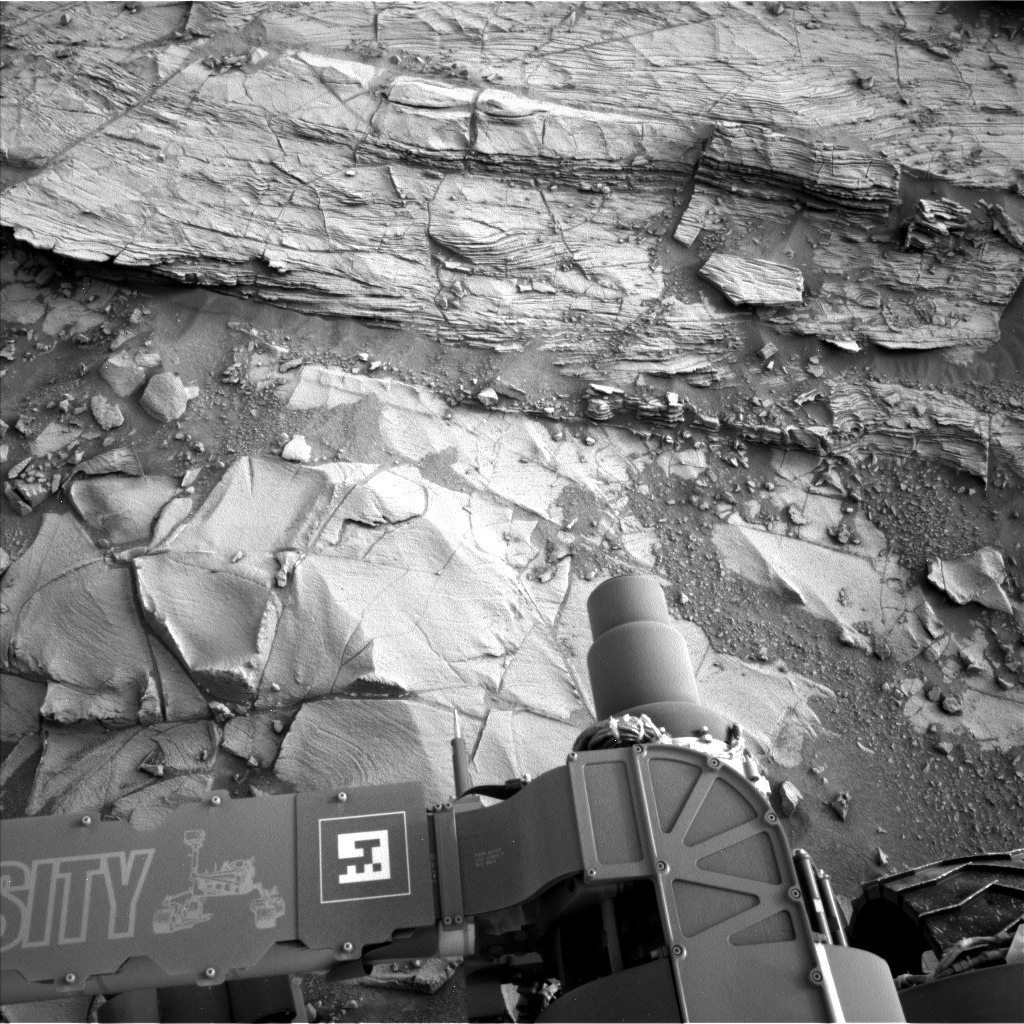
Sol 813 Update from Lauren Edgar: Brushing off the dust at Book Cliffs (18 November 2014)
After a successful drive on Sol 812, Curiosity is well positioned for contact science at the Book Cliffs outcrop. We’ve been taking some really interesting MAHLI images lately, including this one from Sol 810 of the target “Potatoe” ). The plan today is to use the Dust Removal Tool to clear off a fresh surface at the lower part of Book Cliffs (at a target named “Punchbowl”), and then characterize the cleared surface using the MAHLI and APXS instruments. We’ll acquire MAHLI images under different lighting conditions to study the rock textures, and APXS will provide information about the bulk chemical composition of the target. We’ll also acquire MAHLI images of the target “Old Dad Mountain,” which is a slightly more resistant part of the lower outcrop. The plan also includes imaging to prepare for possible contact science on the upper part of Book Cliffs, and a Navcam observation to monitor atmospheric activity above Mount Sharp. Looking forward to more contact science tomorrow!
Protect Our Shared Future
You help us defend humanity and prevent asteroid impacts. Donate now to become a Planetary Defender!
Donate