
 Explore Worlds
 Find Life
 Defend Earth


CTX and MARCI -- The OTHER Cameras on Mars Reconnaissance Orbiter

Written by
Tanya Harrison
Mars Expert, Geologist, and Fellow of the Outer Space Institute
January 25, 2010
The following was written for The Planetary Society Blog by Tanya Harrison. Tanya is on the science operations team for NASA's Mars Reconnaissance Orbiter (MRO) Context Camera (CTX) and Mars Color Imager (MARCI) at Malin Space Science Systems. She selects targets for, and then analyzes the geology of CTX images, and is one of the writers for the weekly MARCI weather reports. I'm grateful to Tanya for this contribution, since I've been doing a terrible job covering the terrific images coming out of all of Mars Reconnaissance Orbiter's cameras. --ESL
"What?" you might say, "There are cameras other than HiRISE?"
Yes indeed, there are. There are two other cameras aboard MRO: the Context Camera (CTX) and Mars Color Imager (MARCI). CTX acquires grayscale images at a resolution of about six meters per pixel covering areas up to 9,390 square kilometers in one picture. MARCI acquires color images (in seven wavelength bands) at 1 to 10 kilometers per pixel to create a daily global mosaic of Mars in order to monitor the weather. Today, I'm just going to talk about CTX.

Maybe CTX is neglected because of its name. It sounds like all it does is take context images for HiRISE (and CRISM, the imaging spectrometer on Mars Reconnaissance Orbiter), but that's not the case. CTX's almost 10,000-square-kilometer pictures makes it well-suited to create mosaics of large regions. For example, we have nearly complete coverage of the entire Valles Marineris canyon system; we have nearly half of the planet covered in total. CTX has also already covered 12 percent of the planet in stereo and produced mosaics of the entire south polar cap in both winter and summer so scientists could monitor how it recedes.
CTX also monitors (that is, repeatedly images) several locations on Mars for changes or activity such as new impact craters, gully flows, dust devils, wind streaks, dune movement, and slope streaks. This monitoring has paid off, as we've found over 80 new impact sites, noticed a plethora of new slope streaks, and documented thousands of gully locations. But some of the most exciting things we've found thanks to our monitoring efforts are multiple new gully flows, first reported at the 41st Division of Planetary Sciences meeting in Puerto Rico last October.
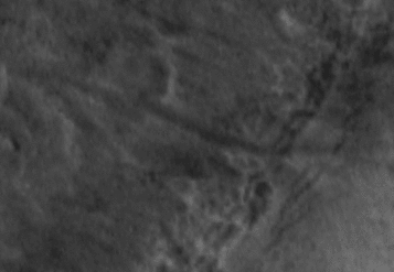
Martian middle- and high-latitude gullies were first observed in Mars Global Surveyor Mars Orbiter Camera (MOC) images in 1999. Appearing to be geologically young, they were repeatedly imaged by MOC to determine whether they were changing. This led to identification of two sites where new flows occurred between 1999 and 2005, including this one in Terra Sirenum:
These features generated a lot of buzz because the deposits were thought to have formed through a mechanism involving liquid water, as gullies appear to be fluvial features. Now, CTX continues the MOC gully monitoring effort, routinely imaging over 600 locations (craters, massifs, pits, etc.) to look for changes in gullies. We compare new CTX images to all pre-existing datasets of sufficient resolution (including MOC, HiRISE, Mars Express HRSC, Mars Odyssey THEMIS VIS, and previous CTX coverage). When a change is suspected, we then direct HiRISE to its location for higher-resolution imaging.
With this monitoring effort, we have found nine more of these types of features where there are images of the gully channels both before and after the flows formed. All of them formed since 2001. For some, we have before-and-after images that constrain their formation dates to within a one-year range. Many of these, such as the example pictured below, are even better demonstrations of how the formation of these features likely involves liquid water than the two flows reported in 2006.

In addition to gully monitoring, we document the locations of every gullied landform on the surface of Mars as the CTX images come down from the spacecraft each day (yes, it's as incredibly tedious as it sounds, as CTX has acquired over 25,000 images thus far in the MRO mission!). So far, MOC and CTX combined have covered about half of Mars. In that area, we've imaged over 4,500 separate gullied landforms (craters, massifs, mesas, etc.) -- that means tens of thousands of individual gullies. In Nirgal Vallis alone there are about 500 individual gullies! This documentation effort has confirmed that gullies are only found in one latitude strip in each hemisphere, from about 27 to 80 degrees north and also from 27 to 80 degrees south.
Some authors have claimed that there are gullies in the equatorial regions as well, but those landforms are not "gullies" in the sense that they lack incised channels. The equatorial features are dry mass movement chutes with alcoves and aprons. While the original definition of a gully given by Malin and Edgett in 2000 consisted of an alcove, channel, and apron, many gullies lack alcoves and/or aprons, and therefore the channel is the key identifier. CTX is capable of resolving over 95% of the gullies on Mars; serendipitously, gullies don't appear to occur in extremely small craters (less than a few hundred meters in diameter), so unless the gully channels are incredibly fine or partially obscured by something like dunes, CTX can pick them out.
I'll leave you with some CTX eye candy of just a few of these tens of thousands of gullies on Mars. If you'd like to browse CTX images, some of them plot on Mars in Google Earth, and there is also a map interface available here. The number-and-letter codes underneath each image take you to a page where you can browse the full CTX photo.
Start exploring!


Protect Our Shared Future
You help us defend humanity and prevent asteroid impacts. Donate now to become a Planetary Defender!
Donate