
 Explore Worlds
 Find Life
 Defend Earth


Mars Exploration Rovers Update: Opportunity Scuffs Up Signs of Past Water at Marathon Valley
Sols 4362 - 4391

Written by
A.J.S. Rayl
Contributing Editor, The Planetary Society
June 6, 2016
Mars Exploration Rover
NASA / JPL-Caltech / Maas Digital
Opportunity spent the first half of May digging into an outcrop, taking dozens of panoramic images from her site on the south wall of Marathon Valley at Endeavour Crater’s western rim, and basking in the Martian spring weather. And then, as Mars Exploration Rover (MER) officials prepared to present the mission’s plan to keep the expedition roving through 2018, the veteran robot field geologist scuffed up a new target and uncovered a small bounty of geological gems.
“Mars has totally surprised us, again,” said Ray Arvidson, MER deputy principal investigator, of Washington University St. Louis.
The MER team had commanded Opportunity to drag her left front wheel across one of the deep-red pebbled bands of soil that the scientists have seen around Marathon Valley. They expected the rover would simply excavate some of the red pebbles.
Instead, just below the surface the rover scuffed, the scientists saw something “wonderful,” as Sir Arthur C. Clarke might have put it: a colorful trove of sands and pebbles, including evidence for various sulfate-rich salts – all of which indicated that water was once there.
For months now, the MER scientists had conjectured that these deep-red band areas are aqueous alteration zones, with the bands being troughs that formed of porous fractures where groundwater probably preferentially moved. Even so, the rover’s “uncovery” was not what they thought they would see.
“It’s a big, big surprise,” said Steve Squyres, MER principal investigator, of Cornell University. “It validates the notion that these are indeed places where there has been significant aqueous alteration, but I don't think there is one of us who expected this.”
Opportunity has been exploring Marathon Valley’s south wall since last October and through the Martian winter, searching for the mother lode of clay minerals that the Compact Reconnaissance Imaging Spectrometer for Mars (CRISM), an instrument on the Mars Reconnaissance Orbiter (MRO), first detected there years ago.
Clay deposits are primarily composed of phyllosilicate minerals that contain varying amounts of water in their molecular structure, and therefore are a sign of past water, and usually more neutral rather than acidic water, the likes of which we might drink on Earth. But the clays, typed as smectites, weren’t exactly staring the rover in the face.
Based on all the science data that Opportunity has returned since entering Marathon Valley last July, the scientists have come to conclude that the smectite remnants must be spread all around Marathon Valley, and that the clays probably formed in a small amount of water. The robot’s findings from Pierre Pinault, an outcrop located on a slope along the southwestern part of the valley’s south wall, which the rover examined in detail in April and May, support that hypothesis.
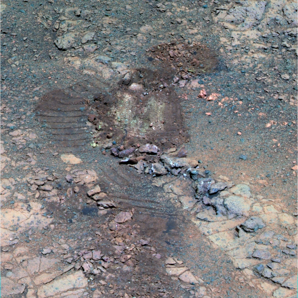
Scuffed up treasure
Opportunity took this image with her Panoramic Camera (Pancam) on her Sol 4379 (May 19, 2016). It shows the deep red band or trough that she scuffed up in May, the place where the MER science team found a small bounty of minerals that are evidence of past water.NASA / JPL-Caltech / Cornell / ASU
The scientists remained confident however that the deep red bands running in between and around the outcrops on the valley floor and along the slopes of its walls are ancient fractures that effectively created paths the water followed. That would suggest that the geology found in these areas will be more significantly altered by water than the outcrops – and evidence for that popped up in the scuff.
“We're still figuring out what it means,” said Squyres. “We have to learn more about the rest of the chemistry before we can make any conclusions. But it is telling us something about water moving things around.”
“The science team is very excited by what they've found inside the scuff,” said John Callas, MER project manager, of the Jet Propulsion Laboratory (JPL), home to all of NASA’s Mars rovers. “So, just when we thought we were done here – we are now going to spend a few more sols looking into this.”
Although most of the MER ops team members got a break over the long Memorial Day weekend, Opportunity hunkered down to glean all she could about the chemistry of the colorful grains of soil and pebbles inside the scuffed trough. And with the Martian winter, the mission’s seventh, in the rear view mirror, life on Mars was good.
Diffuse water-ice cloud clouds in the upper atmosphere, part of the Aphelion Equatorial Cloud belt, passed over the rover’s site at the top of the month, and may have caused the rover’s power levels to dip briefly, but overall the solar-powered robot is bounding into the Martian spring with lots of energy.
The greater concern in spring and summer are Mars’ notorious dust storms and those picked up in May, according to Bruce Cantor and the team at Malin Space Science Systems that operates the Mars Color Imager, known simply as MARCI. The camera, which like CRISM is onboard MRO, acquires a global view of the Red Planet and its weather patterns every day. To the MER mission’s good fortune, Opportunity “enjoyed storm-free skies” throughout the month, as the MARCI Weather Report put it.
For this veteran rover though, there’s more to life than surviving Mars. Despite all her landmark achievements – which include being the first robot to ground-truth clay minerals on the Red Planet, the first to drive into a crater, the first to survive a pummeling, planet-encircling dust event, the first to investigate a Noachian Period crater, and the first to finish a marathon on another planet – this robot hero must vie for survival on her home planet too.
It’s nothing new for this intrepid ‘bot. Every two Earth years, each planetary mission that seeks to go beyond its primary mission must apply for an extension and present its plan before a review board. These boards review the missions and advise NASA. Ultimately, NASA officials make the decision on which missions will be granted extensions.
At the time of this writing, the MER mission is only funded through the end of this year. But during the last week in May, not long after Opportunity sent home the big sulfate surprise, Squyres and Callas headed to San Diego to appear before a Senior Review panel assembled to consider extension proposals from each of the current Mars missions. On May 24th, the mission’s leaders presented MER’s tenth extension plan.
“I think it went well,” said Callas. Squyres agreed. The two are holding close the exact details of that plan, but as Squyres hinted last month: “The plan will include some of the most exciting stuff we’ve ever done with Opportunity, stuff that no rover has ever done before.” Now they wait … the world waits.
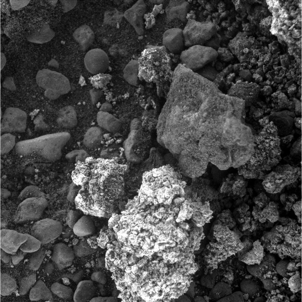
Sands, pebbles, and a Field
Opportunity took the images for this mosaicked close-up with the Microscopic Imager on her Sol 4389 (May 29, 2016). It shows a tiny portion of the area the rover scuffed up. The bright chunk at the bottom is the target named Joseph Field, which the robot was studying as May turned to June.NASA / JPL-Caltech
Since the halcyon days of Apollo, NASA’s science budget has always been stretched to the limits. The approximate $1.5 billion that is denoted for planetary science must cover all the missions exploring the planets of our solar system, as well as the development of new technologies for future missions. There is always a line-up of new projects clamoring for funding along with the ongoing projects and the competition is Olympic. Consider that MRO, Curiosity (Mars Science Laboratory), Mars Odyssey, Maven, and MER are just the Mars missions seeking an extension.
Being a robot, Opportunity is oblivious, of course, and the MER ops team doesn’t have time to stop and wait. From the moments Opportunity and her twin Spirit landed, the MER teams members have viewed every day of this first overland expedition of Mars as a gift. That has never changed. They’ve got ops everyday and the rover has places to go, new Martian mysteries to uncover, and more records to set.
The MER mission’s prime directive is to “Follow the Water” by searching for geological signs of it and that’s exactly what the mission has been doing. The twin robot field geologists each returned scientific evidence for past water: Opportunity returned evidence for an ancient salty sea during her primary mission and Spirit found solid evidence for past underground water at Home Plate.
But when Opportunity pulled up to the rim of the Noachian Period Endeavour Crater in August 2011, a floodgate of sorts opened. The rover began a journey farther back in Martian time, uncovering geological history that no other surface mission ever had, and the mission began anew.
With Opportunity’s ground-truthing of clay minerals and the team’s discovery of the most ancient Martian terrain on Matijevic Hill in 2012–2013, this rover has sent home some of the most compelling evidence ever acquired on the surface of Mars that long ago there were water-rich environments on the planet where life could have emerged. The research the rover sent home from Marathon Valley in May is giving the scientists fertile ‘grounds’ that may well help them enhance the latest chapter in the story of water at Meridiani Planum, a story they have been writing for the last twelve and a half years.
And yet, there is so much more to uncover at Endeavour. More ancient Martian history is beckoning from just down the crater road a bit, and the MER team is anxious to get Opportunity time trekking back to the past.
“We presented a really exciting story of the extended mission to the Senior Review Board as to what we're going to do when we leave Marathon Valley and we're all just itching to get on with it,” Squyres said. “But we have just come across some of the most surprising chemistry we've found here and as eager as we are to get going, we have to wrap this up properly before we move on.”
So Opportunity continued her study of the colorful bounty in the trough and ended her 13th merry month of May focusing on a yellow pebble (as it appeared the Pancam false color images) that the team named after Private Joseph Field, who like his brother, Reubin, was considered to be among the best shots and hunters accompanying Lewis & Clark in the Corps of Discovery.
Once Field is in the can, the science team will decide what Opportunity will do next. Wherever she is commanded to go, Opportunity is ready to roll. “I sound like a broken record, but the rover is doing absolutely fantastic,” said Bill Nelson, chief of MER engineering at JPL. “We have great energy, the temperatures are pretty much in the sweet spot, neither too warm or too cold, we have experienced no additional anomalies, and everything is going just beautifully right now.”
“Twelve and a half years after landing,” summed up Callas, “we still have a great rover and a great mission.”
NASA / JPL-Caltech / Cornell / ASU
A panoramic glimpse
This picture is one of dozens of Pancam images that Opportunity took of her surroundings from her post on a southwestern slope of Marathon Valley’s south wall in May. It will be stitched together with others for the MER mission’s next major panorama, to be named in honor of Sacajawea, the Shoshone Indian woman who served as an important guide for the Lewis & Clark Expedition. This image was processed in false color, a technique the Pancam team uses to better distinguish the different geological features in the picture.As May dawned at Endeavour Crater, Opportunity was parked on a slope in the southwestern part of Marathon Valley’s south wall, conducting an in situ or contact science investigation on the outcrop the team named Pierre Pinaut, after one of the boatmen on the Lewis & Clark Expedition, official known as the Corps of Discovery.
With 42.78 kilometers (26.58 miles) on her odometer, the robot’s power levels were fairly robust, hovering around 645 watt-hours, nearly two-thirds her capability when she landed in 2004 with clean solar arrays. The solar array dust factor of 0.774, was also excellent, indicating that the solar-powered ‘bot was converting about 77% of the sunlight hitting her arrays. The skies were slightly hazy, with Tau of around 0.508 – and spring was in the air.
Opportunity’s science agenda for May included completing the in-depth study of Pierre Pinault, checking out one of the nearby deep red bands sprinkled with pebbles, and a lot of imaging, specifically 13-filter or full-color Panoramic Camera (Pancam) pictures to be processed into the mission’s next panorama.
Unofficially, the panorama is to be named in honor of Sacajawea, the Shoshone Indian woman who served as an important guide for the Lewis & Clark Expedition, and it will show the smectite rich landscape the rover has been studying for the last couple of months. The image “will be released “soon,” said Planetary Society President Jim Bell, the Pancam science lead, of Arizona State University.
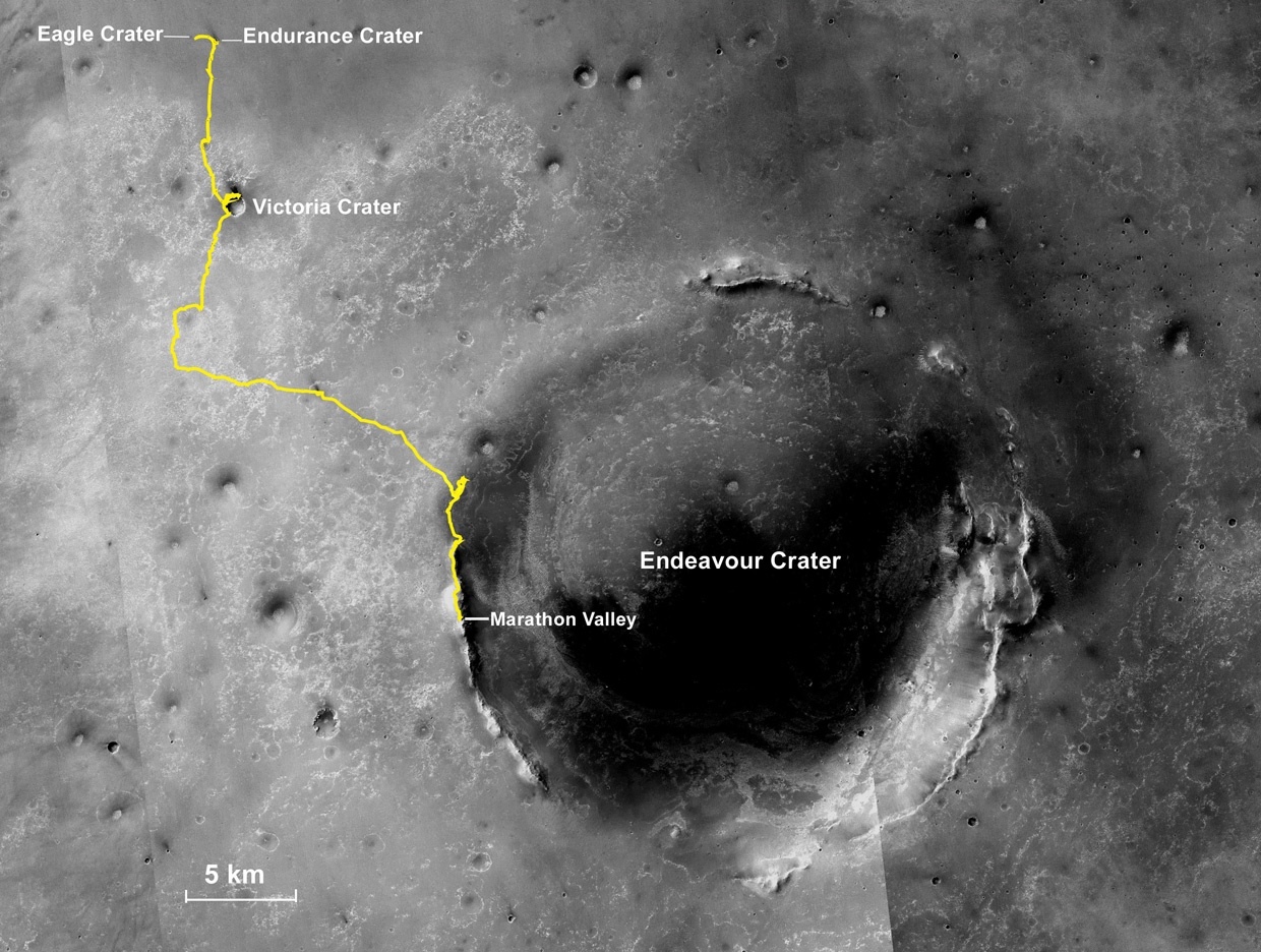
Oppy’s expedition so far
The gold line on this image shows Opportunity's route from the Eagle Crater landing site to her approximate current location. Since August 2011, the MER mission has been exploring the western rim of Endeavour Crater and in July the rover entered Marathon Valley. The base image for the map is a mosaic of images taken by the Context Camera onboard the Mars Reconnaissance Orbiter (MRO). Larry Crumpler, of the New Mexico Museum of Natural History and Science, provided the route add-on.NASA /JPL-Caltech / MSSS / NMMNHS
Opportunity began the month on Sol 4362 (May 1, 2016) taking a few of those Pancam color images of her surroundings, as well as pictures of the target spot on Pinault that the robot brushed at the end of April. The next sol, the robot field geologist pulled out her Rock Abrasion Tool (RAT), ground into the target spot to a depth of 1 millimeter about (0.04 inches), and then placed her Alpha Particle X-ray Spectrometer (APXS) down for a post-grind measurement of the outcrop’s chemical composition.
But on Sol 4364 (May 3, 2016), when Opportunity began to take a routine series of close-up pictures with her Microscopic Imager (MI), the camera ‘hung’ after taking the first picture, and shut down imaging operations. In previous weeks, the MER engineers developed a process to clear the fault as soon as it occurs, allowing all subsequent imaging to proceed. So, the robot continued working without missing a beat, taking more color images that will go into the next panorama, and conducting another APXS integration on Pinault.
The MI started to ‘hang’ last month, an event that had also occurred in previous months with the Pancam and the Navigation Camera (Navcam). A tiger team was assembled to investigate. At first, they thought that perhaps something had happened in the avionics or rover electronics, or maybe there was something in the flight software. But, by Sol 4367 (May 6, 2016), the MER engineers had traced the imaging problems to what turned out to be something as simple as it was confounding – a sequencing error.
“We have a ‘stop imaging’ sequence that pauses imaging, waits for that image to complete, and then stops imaging until we resume,” said Bill Nelson, chief of MER engineering at JPL. “For almost the entire mission, we have been using that sequence before every nap or every time the rover shuts down or changes an activity, as part of our ‘cleanup,’ and it's worked perfectly.”
So why did the sequence used to work and then suddenly not work?
It turns out the ‘stop imaging’ sequence effectively cues the cameras to not shoot anything more even if commanded. But that little factoid was hidden until this past month.
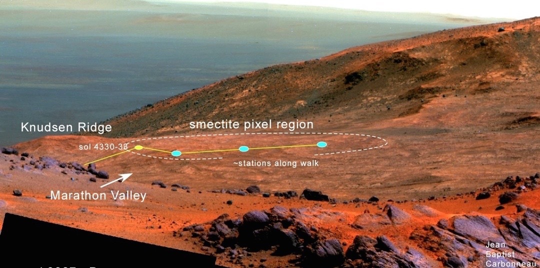
Current roving grounds
Geologist-volcanologist Larry Crumpler plotted Opportunity’s April 2016 walkabout on this image, a view into the interior of Marathon Valley that the rover acquired after completing work on the “purple” rock, Jean Baptiste Charbonneauback on Sol 3937 (Feb. 19, 2015). The rover’s location through May 2016 is approximately marked by the blue dot farthest to the right. Research Curator for Volcanology & Space Science at the New Mexico Museum of Natural History and Science, Crumpler is a MER science team member.NASA / JPL-Caltech / Cornell / ASU / NMMNH / L. Crumpler
The explanation lies in the rover’s switch last year from flash to RAM, from storing data in her long-term, non-volatile flash memory to storing one Martian day’s worth of data in her short-term, volatile RAM memory and downlinking it the same sol. The MER team commanded the switch because Opportunity’s flash, even after three successful reformats, was causing continued, unwanted reboots, as well as ‘amnesia events,’ where the rover was unable to mount or wake-up flash.
“When Opportunity was working in flash mode, we would issue this ‘stop imaging’ sequence right before we would take a nap, because we didn't have to stay awake all day like we do when operating in persistent RAM mode,” said Nelson. “So we would wake up in the morning, do some imaging, issue the ‘stop imaging’ command as part of cleanup, and then nap. Then, when the rover woke up from the nap, it would reset, like software automatically resets, and re-enable imaging. So while the rover was operating in flash, the ‘stop imaging’ sequence issue was hidden by that automatic reset.”
When the rover is operating in persistent-RAM mode and has to stay up all sol, the cleanup usually isn’t done until just before the UHF pass with Mars Odyssey or MRO around sundown. “Turns out the UHF pass automatically issues a pause and resume, and the resume would turn on imaging, but for the most part we would just shut down afterward,” Nelson said. “So that masked the problem in those situations.”
In recent months, and especially recent weeks as Opportunity has begun producing more energy, staying up longer, and performing more activities, the issue was unmasked. “When you disable imaging in the first block, the imaging in the second block doesn't take place and tends to hang-up,” informed Nelson.
The fix is simple: ‘Don't do that,’ Nelson said. “We can pause and resume without that sequence. So we switched to a ‘pause only’ sequence and all our problems went away.”

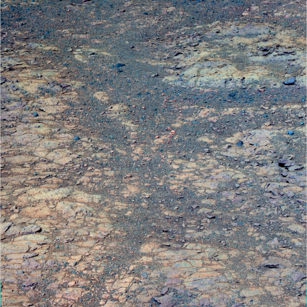
Digging Pinaut
Opportunity took this image of the Pierre Pinault outcrop target that she ground into with her Rock Abrasion Tool (RAT) and the Pancam team processed it in false color. Named for one of the contract boatmen on the Lewis & Clark Expedition, this target helped the MER scientists conclude that the smectite clay minerals here formed in relatively low water conditions.NASA / JPL-Caltech / Cornell / ASU
That was easy. The fix, that is. Finding it took a “change in mindset,” he said.
“It didn't immediately dawn on us that we had been mis-sequencing all these years and the wake-up/shut down cycle or the UHF passes had been hiding it,” said Nelson. “It was only when we got into the right combination of RAM mode and needing to stay up, and having enough energy to work more that suddenly this problem came to the fore.”
All’s well that ends well. Opportunity returned to normal operations on Sol 4367 (May 6, 2016) and successfully captured and sent home the series of close-up pictures needed for a MI mosaic of the RAT grind.
That mosaic in hand, the MER scientists realized that the grind had not gone deep enough. As a result, the MER team commanded the rover to grind again into the target. That’s just what the rover did on Sol 4370 (May 9, 2016), and then, following the routine science protocol, she placed her APXS to on freshly grinded target to see if there was any change in the rock’s chemical composition below the abraded surface.
“We ground approximately 2.3 millimeters deep into the rock,” said Gale Paulsen, Senior Systems Engineer & Deputy Director at Honeybee Robotics & Spacecraft Mechanisms Corporation in Pasadena, the company that created the RAT. “The bit is still looking good and the RAT actuators are still performing nominally. There are no observable signs of bit wear after this grind.”
Opportunity spent the rest of the second week of May finishing her in-depth investigation of the RATed Pinault target. She took the requisite series of MI pictures for a mosaic of the freshly ground target on Sol 4372 (May 11, 2016), and followed that with another APXS chemistry analysis. The next sol, the robot used her RAT to brush clean the ground target of tailings, and then took more MI pictures and again placed her APXS on Pinault.
Clay minerals all around
This image, which Opportunity took with her Pancam the last week in May, is another of the dozens of images that will go into the Sacajawea Panorama that will be released soon, according to Planetary Society President and Pancam science lead, Jim Bell, of Arizona State University (ASU). It shows a few of the deep red bands or troughs, which roughly form a ‘Y’ in the image. The MER scientists are working now to confirm water once flowed here.NASA / JPL-Caltech / Cornell / ASU
Then, on Sol 4374 (May 13, 2016) the robot moved the APXS just 1.25 centimeters (a half-inch), offset from the original target spot, and took another look at the chemical composition with her APXS. And on Sol 4375 (May 14, 2016) Opportunity finished the second week of the month with a drive, backing away from the Pinault RAT hole, and some Pancam color imaging of her work.
“The clay minerals at this location appear to be ubiquitous with the bedrock and appear to have formed at a very low water to rock ratio,” Squyres summed up.
“What we're finding is consistent with everything else we've seen on the bedrock,” added Arvidson. “There's the smectite signature, but we don't see chemical variations that would indicate anything other than minor alteration in water to change some of the minerals to smectite but without changing the composition – that is without leeching any of the more soluble elements away.”
Interestingly, the Mars Science Laboratory scientists are finding the same kind of thing with Curiosity in Gale Crater, said Arvidson, who is a member of the MSL science team, as is Squyres. “We’re beginning to think that maybe the smectite we see [from orbital data] in a lot of crater rims on Mars may represent only modest alteration by water,” he said. “But it’s not surprising because the rims are high.”
That is assuming the water came up from underground, which is the hypothesis that seems to make sense, at least right now. At time of impact by whatever created Endeavour Crater, Arvidson suggests, there may have been “a lot of hot water moving around from the inside, circulating as hot groundwater.” And so the water came up from underground.”
“We don't have a means of dating this, so there's no particular piece of evidence that says that that must have been what got that water going,” said Squyres. “But given that we know that the impact events deposit heat and given that we know that heat can drive convection, the idea that water was driven through these rocks by heat associated with the impact is not an unreasonable one. We just can't prove it.”
There may have been another “water event” in the Endeavour area at some point during the past 3-4 billion years, or perhaps multiple water events. “It could be two separate events. It could be there was a very moderate alteration of everything first and then later some fracturing happened, and then after that another water event that wound up moving through the fractures. But there's no way to separate that out.”
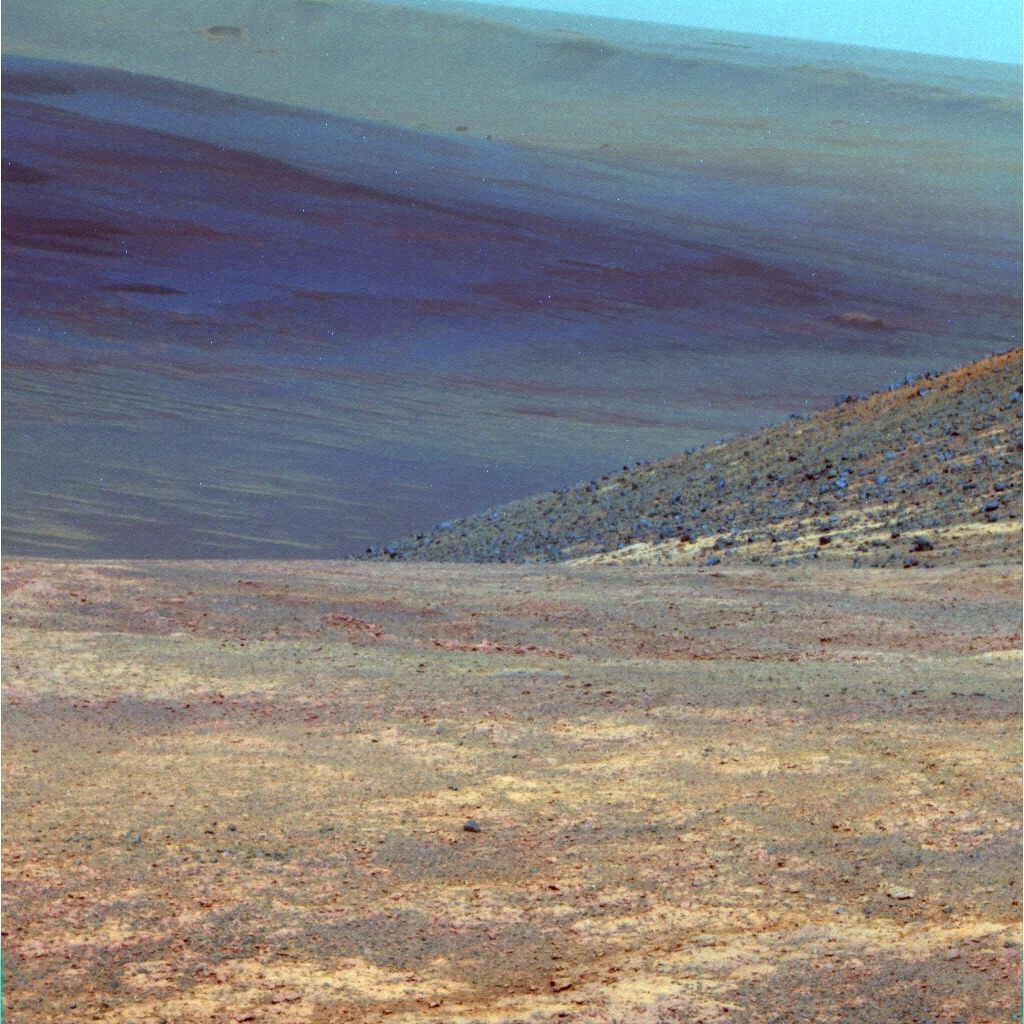
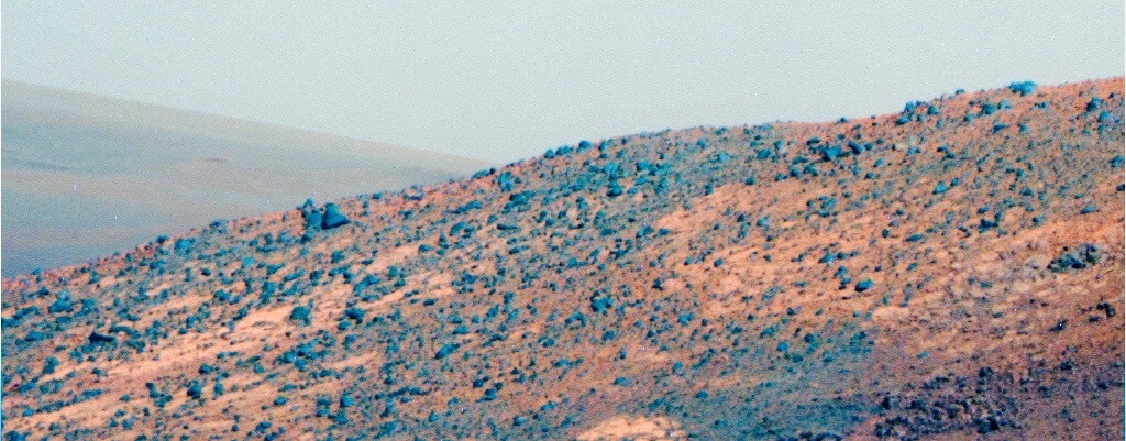
A painted view
Opportunity took this view, looking northwest into Endeavour Crater, in mid-May as part of the mission’s latest Pancam panorama assignment. Although the Pancam team processed this image in false color, the effect is almost like a painting of the rover’s view.NASA / JPL-Caltech / Cornell / ASU
In any case, before the scientists wrapped the investigation at the southwestern part of Marathon Valley’s southern wall, they wanted their field geologist to look inside one of the deep red, pebbled bands. If these features are ancient fractures, then water would preferentially move through them and do a whole lot more leeching in these areas than within the bedrock proper, as both Squyres and Arvidson have noted in previous MER Updates.
As Opportunity roved on into the third week of May, the robot and the team were en route to a Martian surprise. On Sol 4377 (May 16, 2016), the rover dragged her left front wheel across the trough to break up the surface and give the scientists a look under the surface. Then, she backed away to take some color Pancam images of her scuff.
The red pebbles didn’t get broken up much, but the rover’s wheel created two divot holes or pockets where the maneuver began and ended. “Inside, there were the just massive color variations in the Panoramic Camera (Pancam) images that we didn’t expect,” said Arvidson.
On Sol 4379 (May 18, 2016), Opportunity bumped 1.75 meters (5.74 feet) back towards the scuff to set up for a close-up investigation of the torn-up trough. The rover then devoted the next couple of sols to taking more Pancam color pictures for the Sacajawea Pan, as well as some Navcam panoramas.
The rover began her close-up study of the scuffed area on Sol 4381 (May 21, 2016). Following the routine protocol, Opportunity first took MI pictures of a chosen spot inside one of the divot holes the rover had scuffed up, which the team named after E. Cann, another one of the contract boatmen for the Lewis & Clark Expedition. Then, the robot placed her chemical-sniffing APXS on the same spot. Over the next two sols, 4382-4383 (May 22-23, 2016), the rover offset the APXS by about 1 centimeter on the divot and performed another integration, took more MI mosaic pictures and some more targeted Pancam full color images.
“We saw 25 percent SO3, so there's a lot of sulfur in there,” said Arvidson “That was surprising. It would indicate during one or multiple water events, some sulfur was brought up. It correlates with magnesium and calcium and probably iron. So it's not exactly like Pinnacle Island in Cook Haven, but it’s kind of similar. So what we're doing is what we did with Pinnacle Island, making multiple overlapping or off-set APXS measurements to try and tease out the chemical compositions.”

What it’s all about
In May, Earth and Mars orbited closer to each other than at any time in the last 10 years. On May 12, 2016, the Hubble Space Telescope (HST) took advantage of this favorable alignment and took this image of our favorite other planet. From this distance, the telescope could see Martian features as small as 30 kilometers (18.64 miles) across. Opposition occurred May 22nd, at 11:10 UTC. And Mars’s closest approach to Earth occurred May 30th, at 21:36 UTC, when the planet was 0.503 au or 75.28 million kilometers (46.77 million miles) from Earth. Opportunity is up there now, roving on.NASA / ESA / HST
This research could be indicating that “there was a period of emplacement of sulfate salts – and it may or may not be associated with smectites and red pebbles because this place has been hanging out here for three and half billion years,” said Arvidson.
On Sol 4386 (May 26, 2016), Opportunity made a small turn, moving just 0.01 of a meter (3.93 inches). It would be her last move of the month and it brought her odometer to 42,791.53 meters (42.791.53 kilometers or 26.589 miles). In addition to taking more panoramic pictures, the robot spent the last weekend in May examining the bright, yellow pebble target in the trough named after Joseph Field, a study that would extend into June.
At the time this report was being edited for posting, there was no final analysis on Field and there was no decision as to how much longer Opportunity would study the little geological gems found in the scuffed up trove.
One much-discussed, final science assignment for the rover in this area is likely to be a drive deeper into the “red pixels,” the area on this southwestern slope on Marathon Valley’s south wall that corresponds to the team’s CRISM mineral map where the strongest signature for smectites is defined by red pixels. Opportunity likely will check out a couple of targets there, “just to make sure we haven’t missed anything,” said Arvidson.
“There is a pretty strong sentiment that just for the sake of completeness we should drive through the middle of the most phyllosilicate-rich portion of Marathon Valley before we actually exit the valley,” Squyres said. “So we probably will do that even though we really feel we have figured out the phyllosilicate story here now.”
Past that, science team members have been talking about having the rover drive north across the valley floor to finish mapping the northern wall and to examine one of the dark rocks that has fallen off the wall there. When exactly the robot field geologist will leave Marathon Valley is anybody’s guess right now.
Ready, willing, and wanting as the team is to rove on, MER is a science driven mission and Squyres has never been one to predict exits, especially when geological clues the likes of which Opportunity uncovered in May are right there in front of the rover. “As it turns out, May was one of the most interesting months of the entire time that we've been in Marathon Valley,” he said. “We want to figure this out. What we do next all depends on what we find here.”
“Sure” and “obviously” are strong words, as Squyres has noted more than once to journalists during this mission. But this much is certain: there is much more to discover at Endeavour Crater, more Martian mysteries to discover and solve, and more ancient history to uncover. NASA and Mars willing, Opportunity will be continuing her expedition for as long as her wheels turn. And, just as she has from the beginning, the rover that loves to rove will take the world along for the ride.
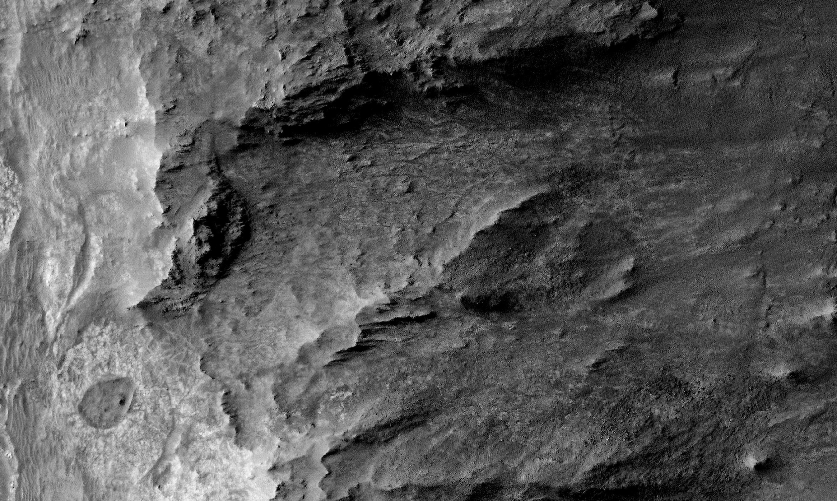
NASA / JPL-Caltech / University of Arizona
Overhead view of Marathon Valley
The HiRISE camera onboard the Mars Reconnaissance Orbiter took this overhead image of Marathon Valley. Opportunity entered the valley in July 2015, after studying Spirit of St. Louis Crater, visible in lower left of image. The valley stretches west to east (left to right in image) about 330 meters (1100 feet) cutting into the 22-kilometer (13.7- mile) diameter Endeavour Crater (to the right and off image).Protect Our Shared Future
You help us defend humanity and prevent asteroid impacts. Donate now to become a Planetary Defender!
Donate