
 Explore Worlds
 Find Life
 Defend Earth


Mars Exploration Rovers Update: Opportunity Rocks on Ancient Water During Walkabout
Sols 4125–4154

Written by
A.J.S. Rayl
Contributing Editor, The Planetary Society
October 2, 2015
Mars Exploration Rover
captionNASA / JPL-Caltech / Maas Digital
The Mars Exploration Rover Opportunity continued her walkabout around Marathon Valley in September and sent home more evidence of significant water alteration and, perhaps, an ancient environment inviting enough for the emergence of life. Yet, the actual locations of the clay minerals the rover and her team are looking for still remain something of a mystery.
Marathon Valley, which cuts downhill from west to east for about 330 meters (about 1100 feet) through the western rim of Endeavour Crater, is turning out to be a kind of Martian geological Disneyland. Since Opportunity entered the valley in July and began imaging its walls and floor, the MER scientists are finding it almost familiar. "Marathon Valley is looking somewhat like the mountains in the Rockies that have had a lot of water alteration, places where you go prospecting for gems and minerals," said Ray Arvidson, deputy principal investigator, of Washington University St. Louis.
Opportunity spent September prospecting for clay minerals at rock outcrops that are deep red, redder than most everything else on the Red Planet. Finding the remnants of ancient clays and characterizing the locations of different kinds of phyllosilicate clay minerals, typed as smectites, is the mission's primary science objective in Marathon Valley. These clays form in neutral to high pH or alkaline water on Earth and provide strong evidence that water much like we drink has flowed through the valley.
The MER scientists know the clay minerals are there. A team working with data taken by the Compact Reconnaissance Imaging Spectrometer for Mars (CRISM), an orbital instrument searching for signs of past and present water, found the clay remnants in 2009. CRISM is onboard the Mars Reconnaissance Orbiter and is now also functioning as the mineral detector for Opportunity.
A co-investigator on CRISM, Arvidson created a special mineral map utilizing additional CRISM data so that the team can better guide Opportunity on the quest to identify the smectites. With that map overlaid on the terrain map the team uses to help navigate the rover, it sure looks like she's right there, amidst a bounty of clays.
For the last several months, the robot field geologist has been roving around and finding a lot of breccia, rocks hurled up and/or composed of rock and debris that came from whatever created Endeavour Crater. So far, Opportunity has not found any of the most ancient, Noachian Period bedrock, Matijevic Formation. Yet the red zones are different, and “really, really red,” as Arvidson put it, and that to the geologist's eye would seem to point to evidence of past water.
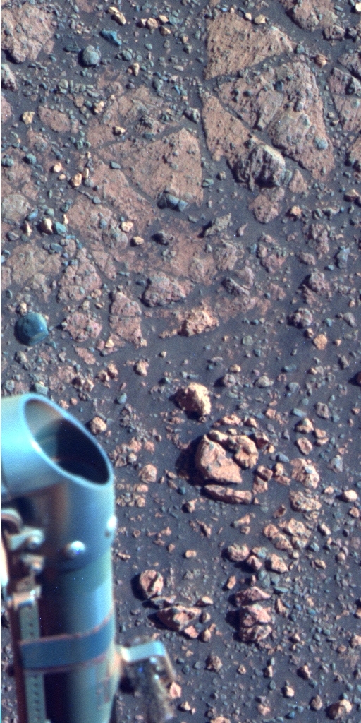
Pvt. Goodrich
During the first half of September, Opportunity used her Pancam to take this image of Pvt. Silas Goodrich, named for one of the members of the Lewis & Clark Expedition. "The big bright pebble about one-third up from the bottom of the frame is Mr. Goodrich," said MER Deputy Principal Investigator Ray Arvidson, of Washington University St. Louis.NASA / JPL-Caltech / Cornell / ASU
The notion discussed in last month's MER Update that the smectites may well be spread all over Marathon Valley and that the rover is and has already been roving over them seemed to gain steam in September.
"We suspect that the red zones may be the phyllosilicate [clay minerals] carrier in this region," said Steve Squyres, the MER principal investigator, of Cornell University. "The working hypothesis is that the floor of Marathon Valley is laced by a network fractures. These fractures provide zones of weakness along which fluids can migrate, and then the migration of those fluids produces local alteration, which changes the color, which changes the chemistry, which changes the mineralogy of the rocks."
"There are a lot of places we're seeing in Marathon Valley that appear to have had significant water flowing through the cracks, and we think the distribution of the really red zones we're seeing corresponds to the distribution and locations of the smectites in the orbital data," said Arvidson.
Opportunity spent most of the month at a couple of those places, named Private Silas Goodrich and Private George Gibson after members of the Lewis & Clark Expedition, officially called the Corps of Discovery. Intriguingly, these deep red outcrops feature distinctive, swirl patterns.
"We're looking at a set of outcrops that are relatively planar, but have this kind of swirling pattern in plain view that might be associated with fractures or differential erosion of layering," said Arvidson. “Everything is red on Mars. It's a question of how red. But much deeper, stronger red that we see here speaks of the presence of minerals like iron oxides, signs of the presence of past water," he said.
After months of working in RAM mode – storing her work in the volatile random access memory and then sending it home before shutting down to sleep – Opportunity got her long-term memory back in September. But the robot likely won't be using it for long since she continued to experience the same issues she’d been having for more than a year, despite the fact that flash has been reformatted three times.
The latest reformat, which took place in March this year, involved installing new flight software that enabled the erasing and masking off of the flash memory's bank 7, the bank to which the MER software engineers had traced the problems. However, while Opportunity used her flash in September, she suffered a handful of amnesia events, where she fails to write or save data before shutting down to sleep, and one unexpected reboot.
The rover’s flash memory is non-volatile, a lot like your flash drive. As non-volatile memory, it will save all the rover’s data even when the rover sleeps, or in your case, a long, long time, provided you save the data being transferred before taking the flash out of a larger computer hard drive.
Flash is a valuable asset for the MER mission, because the rover can store hundreds of images and other science data for downlinking later when the “bandwidth” at the Deep Space Network (DSN) is available. This non-volatile memory has allowed for all those huge, breathtaking images of Martian landscapes that have become a hallmark of this first overland expedition of Mars.
The MER software engineers are in the process of examining all the code in bank 7 to search for any clues as to why the rover continues to suffer amnesia events and sudden reboots. "We really have very little experience with the current version of flash memory," said Bill Nelson, chief of MER engineering at the Jet Propulsion Laboratory (JPL).
That's because after the first signs of issues after the new flight software was installed in March, Opportunity was put into “persistent RAM mode” to keep the mission on track and get the rover into the valley within a safe range of her winter haven at the southern end of Marathon Valley. “These excursions using flash will allow us to see if we’re going to be able to use it and how much,” Nelson said.

Noel W. Hinners
On Sep. 5th, the world lost one of the great leaders in planetary exploration, Noel William Hinners. "Noel did everything you could do at NASA, basically," said MER Principal Investigator Steve Squyres, of Cornell University. Beyond that, those who knew him best remembered him as "thoughtful," "conscientious," "hard working," and "kind" – "a distinguished man" and "nice guy." The MER team named the most spectacular ridge in Marathon Valley in his honor.NASA
Given the mission's seventh Martian winter is on the horizon, Opportunity and her team are ready, prepared, and ever alert. "The rover and the team are doing surprisingly well," reported Nelson.
Opportunity had decent energy levels roving into the month, but as the temperatures dropped and the Sun rose and set lower on the horizon, the rover’s power levels dropped, slowly, steadily. By month's end, the rover was producing about 1/3rd her full capability with clean solar panels.
It’s all to be expected as autumn turns to winter. The good news is that "everything looks about how we expected," said Jennifer Herman, the MER power team lead and a subsystem engineer at JPL.
At the same time, energy is a concern. "We are being challenged by staying where we are,” said John Callas, MER Project manager, of JPL. "In a couple of weeks, we need to be on those north-facing slopes at the southern end of Marathon Valley.”
There, the rover’s seventh winter haven offers a number of ideal north-facing slopes where the solar-powered rover can position herself to get the most amount of sunlight throughout the harsh season. There’s no panic. The southern end of Marathon Valley is estimated to be just two to three drives away, nuthin' for this rover that loves to rove. It’s just that there are just so much science, so much ancient geology and so little time.
Since time was becoming of the essence, the team chose to have Opportunity rove on, leaving further investigation of Gibson and its multiple layers for the spring, and return to Private Robert Frazer to take a full color panoramic image of the red zone outcrop the rover dug into in August.
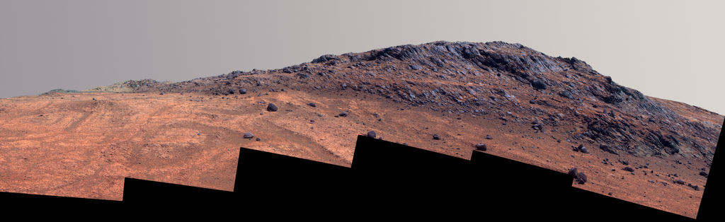
On September 25th, NASA/JPL-Caltech issued a press release and new image that shows Opportunity’s view of part of Marathon Valley’s north wall. It’s a striking mosaic of the north wall and the ridge above the wall that the team named Hinner's Point, after Noel W. Hinners, a legendary leader in space exploration.
"Noel was really one of the greats of our business," said Squyres.
A geologist and soil chemist by education and training, Hinners was one of the most beloved leaders in America’s venture into space, one of the good guys. He died of cancer September 5th, at a hospice center in Littleton, Colo. He was 78.
Hinners held various titles at NASA in the 1970s and 1980s including associate Administrator for Space Science (1974–’79) and Chief Scientist (1987–’89). He also served as director of Smithsonian’s National Air and Space Museum (1979–’82), and NASA’s Goddard Space Flight Center (1982–1987). His gift to the world was his vision and down-to-Earth ability to get science missions off the launchpad, from Apollo efforts to collect Moon rocks to mapping Mars to the Hubble Space Telescope's venture to see beyond and back in time to galaxies never before seen.
"He was enormously influential in everything we've done in planetary exploration in this country for the last 30, 40 years," said Squyres. "He was a visionary and he was always very down-to-Earth, very approachable, and personable."
"Noel was a distinguished gentleman and a genuinely nice person," said Arvidson.
As the calendar turned from September to October, Opportunity was beginning a traverse downhill and deeper into Marathon Valley on her walkabout and working on mapping the floor. "We will be stopping after each drive to look back uphill, to really characterize and color the lay of the land," said Arvidson.
Then, in coming weeks as autumn falls to winter, the rover will head for the friendly slopes in the southern part of the valley. "Our expectation is that Opportunity will be able to remain mobile through the winter," said Callas.
NASA / JPL-Caltech / Cornell / ASU
Hinner's Point
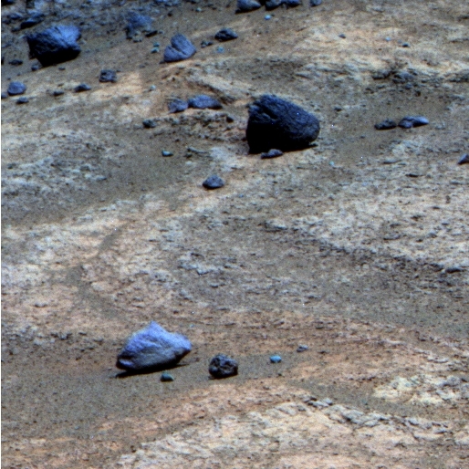
Opportunity used her Panoramic Camera (Pancam) to capture this view of part of Marathon Valley's northern wall. The scene is dominated by a summit the team named Hinners Point, after Noel Hinners, the space exploration leader who passed away Sep. 5th. "It was very important for this team that we find something great to name in his memory and this ridge is one of the most impressive topographic features we've seen in quite some time," said MER PI Steve Squyres. "If you're in Marathon Valley, it's the thing on the skyline." The image, which was processed in false color by the Pancam team, also shows a portion of the valley floor with the swirling red zones where the rover has found more evidence of water alteration.After spending the better part of August at Private Robert Frazer, Opportunity departed and drove into September. She headed west about 14 meters (46 feet) on Sol 4125 (September 1, 2015) to close in on another redder-than-red rock outcrop that lured the team with its patterns and swirls, named Private Silas Goodrich.
"We were drawn to Private Silas Goodrich, because it's much redder than the surrounding rocks," said Arvidson.
To a Martian geologist’s eye, this deep red color pops from all the surrounding red that is Mars, and indicates the presence of iron oxides, signs of past water.
The robot field geologist bumped just 65 centimeters (26 inches) towards a chosen dark red rock in the Goodrich target area and began her up-close science campaign on Sol 4127 (September 3, 2015).

Oppy's long and winding road
The gold line on this image shows Opportunity's route from the Eagle Crater landing site to her approximate current location. Since August 2011, the MER mission has been exploring the western rim of Endeavour Crater and in July the rover entered Marathon Valley. The base image for the map is a mosaic of images taken by the Context Camera onboard the Mars Reconnaissance Orbiter (MRO). Larry Crumpler, of the New Mexico Museum of Natural History and Science, provided the route add-on.NASA /JPL-Caltech / MSSS / NMMNHS
On Sols 4130 and 4131 (September 6 and September 7, 2015), the rover placed her Alpha Particle X-ray Spectrometer (APXS) on the first chosen target on the outcrop for an overnight analysis of the rock's chemical composition. Then, following what has become the routine science protocol, the robot used her Microscopic Imager (MI) to take the pictures needed for a large mosaic of that first surface target on Goodrich.
As the second week of September got underway, Opportunity was still managing to produce around 350 watt-hours of power. But the winter hasn't even actually begun and seasons on Mars are about twice as long as seasons on Earth.
True to her robot personality, Opportunity focused on the next target within arm’s length, in the Private Silas Goodrich bedrock, just off-set from the first. After taking pictures for a MI mosaic she used her APXS to measure the chemical composition on Sol 4133 (September 9, 2015).
The robot completed a Navigation Camera (Navcam) panorama on Sol 4134 (September 10, 2015) and then turned her APXS back on the second Goodrich target and took more chemical measurements through the evening of Sol 4135 (September 11, 2015).
Opportunity moved her Instrument Deployment Device (IDD) or robotic arm again on Sol 4136 (September 12, 2015) to conduct another up-close inspection with her MI and APXS on a third surface spot on Goodrich, just off-set from the first two.
Two sols later, the rover’s team on Earth commanded Opportunity to switch on her flash memory and began “a toe dip diagnostic test” of the errant memory drive. "On September 14th, the rover’s Sol 4137, we commanded the rover to disable persistent RAM mode and use flash,” said Nelson. “That took effect on the next wake-up Sol 4137 at 18:30 local Mars time."
On the Martian morning of Sol 4138 (September 14, 2015), Opportunity woke up in flash and spent the sol collecting panoramic images with her Navigation Camera (NavCam) and Panoramic Camera (Pancam), taking full advantage of her long-term memory capability.

Marathon Valley overhead
The HiRISE camera onboard MRO took this overhead image of Marathon Valley, which stretches about 330 meters (1100 feet) into the 22-kilometer (13.7-mile) diameter Endeavour Crater (to the right). Opportunity spent September 2015 exploring near the valley's northern wall, top third of image.NASA / JPL-Caltech / UA
"We did a 1-to-1.5 day step back into Flash," said Callas. "We did have an amnesia event, but it was benign, and things seemed to be okay.” The team was planning a longer test of flash memory for the final week of the month.
With the exception of the benign amnesia event, which occurred during the time the rover woke-up to go into DeepSleep, the flash seemed to have worked well enough. “Since we had been in flash mode, no science was lost,” Nelson noted. “It was retained in flash." The rover “popped out of flash on Sol 3149 which was September 15th,” he said.
After examining three different target spots on Private Silas Goodrich during the first two weeks of September, the MER scientists found the deep red rock to be low in silicon and iron. “It looks like the other really, really red places we've been,” said Arvidson.
If Goodrich is low in iron that would seem, at first blush, to not support a flowing water hypothesis. However, said Arvidson, “it's low in iron and some of the remaining iron has been transformed to one or more iron oxides."
Opportunity, back in RAM mode, drove on, taking a quick 4-meter (13-foot) jaunt, just downhill relative to Goodrich, to another alluring outcrop nearby that the team called Private George Gibson, after another member of the Lewis & Clark Expedition. And, like Frazer and Goodrich, it featured dark red zones. In addition to its deep red features, the MER scientists were draw to Gibson because of its "multiple layers, strata, exposed by erosion,” said Arvidson.
Although the rover aimed for a deep red target, she wound up on a less desired spot. "We got a tan-red rock, less red, but it's still slightly different than the surrounding rocks," said Arvidson.
Communication issues complicated things for the mission during the third week of the month. Opportunity’s location within Marathon Valley in September was an area where high walls to the north and west can present a challenge for low-elevation Ultra-High-Frequency (UHF) relay passes to the west, passes the rover uses to uplink her sol’s work when working in RAM mode.
"We're in this deep valley and the valley wall blocks the low elevation UHF passes," Callas summed up. Nevertheless, the rover successfully performed its science campaign on the surface target on Gibson that included the routine MI mosaic and APXS chemical analysis.
There was a failure to uplink on Sol 4141 (Sept. 17, 2015). No data were received, because the orbiter's flight path was below the elevation on the valley ridgeline. However, Opportunity had successfully completed her work on the surface target, Private George Gibson taking a MI mosaic and analyzing the target's chemistry with the APXS. Even though she was working in RAM-only mode, the APXS has its own non-volatile memory, and so that chemical analysis was downlinked later.
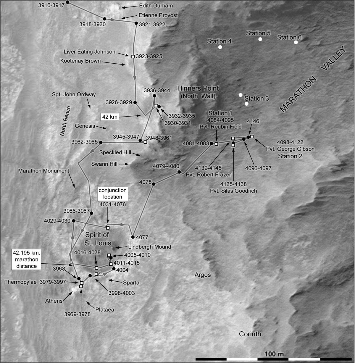
Opportunity's recent roves
This map of Opportunity's recent rovings and science stops was produced by Phil Stooke, an associate professor at the University of Western Ontario in Canada, author of The International Atlas of Mars Exploration Vol. 2, Spirit to Curiosity: 2004 to 2014, to be published by the Cambridge University Press later this year, and an active member of UnmannedSpaceFlight.com. The base image was taken by the HiRISE camera onboard MRO.NASA / JPL-Caltech / UA / P. Stooke
Opportunity took another set of pictures for the MI mosaic of Gibson on Sol 4144 (September 20, 2015) and then stowed her IDD in preparation for driving. Not long after, another failure to uplink occurred when the high ridgeline of the valley once again obscured the low-elevation pass on Sol 4145 (September 21, 2015). The team on Earth received "very little data," said Callas.
On Sol 4146 (Sept. 22, 2015), Opportunity switched from RAM-only operation back into flash to begin a longer test of the non-volatile storage system. "When we masked off bank 7, we saw some problems, but didn't know how frequent those errors would be, and because there was a push then to get into Marathon Valley, we put the rover into persistent RAM mode and have been operating that way since this month,” said Nelson. “We're trying now to go back into flash and gather some experience.”
"Our plan was to get a week in flash to see if we have re-sets and how many amnesia events we have, to get some statistics of how reliable, how dependable the flash might be,” said Callas. “If it's reasonably dependable, then we can use flash. Or use it periodically when we need to, particularly when it gives us an energy advantage or a scientific advantage, when we collecting a big panorama all at once.”
"The only way to find out if or how much we can use flash is to try," summed up Squyres.
The team chose the last week of September to test flash for a couple of reasons. “One is that our power is going to continue to decrease as we move further and further into winter,” said Nelson. “At lower power levels, recovery – if we have to – might become more difficult. Secondly, this particular period of time – the phasing of the two planets and therefore the phasing of when we do the two uplinks that command us in and out of flash memory – happened to fall at times that are anywhere from mid-day to early evening. That means they are easy for us to support.”
If the team had chosen a different week, some engineers would have had to report for work whenever the team would be sending commands to Opportunity, even in the middle of the night. That's because a JPL has directive requires an independent check of all real-time commands sent to the spacecraft. “We've dubbed this a second pair of eyes,” said Nelson.
It may be that Opportunity’s flash is “kind of like that car in your driveway that's kind of unreliable and stalls out every once in a while, but it still has some utility,” as Callas put it. “You can still take it when you need to get to the local grocery store, but you're not going to use it for a cross-country trip.”
The systematic read-out of bank 7, which the MER software engineers began working on last month, continued in September. "We've been using low level commands to read out, address by address, the contents of bank 7 to see if there's anything in there that tells us anything," said Callas.
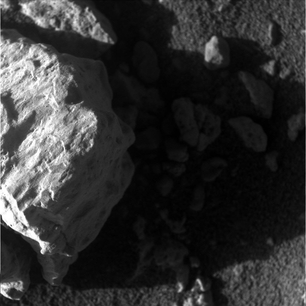
Goodrich up close
As part of her investigation of Pvt. Goodrich, Opportunity took this mosaicked picture with her Microscopic Imager during the first week of September. Although Goodrich does not look so red in this image, it is deep red, redder than most of the other rocks the robot has checked out during the 11 years and 9 months of her mission.NASA / JPL-Caltech
Bank 7, which is 1 of 8 banks in the rover's flash, is the part of the memory system to which software engineers traced the amnesia and reboot issues. In March, that bank was erased and masked off in March. "We're looking see if they get any errors or complaints from any address in bank 7, and what those errors are since they should all be erased,” said Callas.
So far, so good. To date, the team is about halfway through the read-out and everything is turning up 1's. With this memory system, that indicates bank 7 was erased.
Yet, Opportunity is still suffering the same issues that led to the masking of bank 7 and the ops software engineers have still not determined why the flash issues are continuing. Since the bulk of the rover’s flight software is stored in bank 0 of Flash and because there is, ostensibly, some commonality between bank 0 and the rest of the flash, the rover's flight software, theoretically, could be at risk.
"Bank 0 is configured as a memory and it's EDC enabled," said Nelson. [EDC stands for Error Detection and Correction.] "So if there are any bit errors, EDC should correct them or at least flag them, so we know," he pointed out.
But what if there is something more global going on? What if the problems the rover is experiencing have to do with, for example, the power supply rather than with the flash itself?
The MER ops engineers are ahead of the game. As a means of protecting the mission, they are now investigating the possibility of putting a copy of the latest flight software, R9.4, into the rover's other non-volatile memory system, the Electrically Erasable Programmable Read-Only Memory (EEPROM), just in case. "That's the major thrust of what we're doing on that score right now," Nelson said.
At the same time, a group of the original MER software engineers is delving deeper into an investigation of the chips that make up the flash memory to see what that might reveal.
It may be that the flash memory is degrading. "If flash is degrading, well, what do you do about that? You either use it or you don't," said Nelson. “Not using it would be a lot like having that memory give up the ghost on you.”
Although there is still plenty to study in the multi-layered Gibson outcrop, the MER team decided to command the rover to get on with the walkabout. The scientists decided, however, to first return to Private Robert Frazer to get a Pancam 13-filter image of the grind that the rover dug with her Rock Abrasion Tool (RAT), an image they didn't get when the rover was there last month, said Arvidson.
Pvt. George Gibson
Opportunity took this image in late August of one of the sites with swirls and deep red terrain, which the team dubbed Pvt. George Gibson, after a member of the Lewis & Clark Expedition. "We were drawn to this area because of the swirling pattern and because it is much redder than other areas," said MER Deputy Principal Investigator Ray Arvidson, of Washington University St. Louis.NASA / JPL-Caltech / Cornell / ASU
The rover completed her departure from Gibson on Sol 4146 (September 22, 2015) successfully, but near the end of that sol during the wake-up for the UHF pass with Odyssey, she had another amnesia event that prevented return of drive-related data on that sol. “We just got down-fill data or engineering data on that UHF pass,” said Callas. Since the rover had been using flash to store her work, the data was safe and expected to be sent on subsequent sols.
Time, communication glitches, and the desire to see more and move on made for an intense end to September. There has been talk, Arvidson said, about returning to Gibson. "During the Martian winter, Opportunity will conduct its measurements and traverses on the southern side of the valley," he said. "When spring arrives, we will probably return to the valley floor for detailed measurements of outcrops that may host the clay minerals."
Meanwhile, Opportunity's rock work in September seemed to bolster the theory that a significant amount of water flowed or pooled or came up from underground back in the Noachian days when Endeavour Crater was formed and perhaps over a great span of millions of years after that. Since the robot field geologist's two mineral detectors, the Miniature Thermal Emission Spectrometer (Mini-TES) and her iron-detecting Mössbauer Spectrometer, can no longer be used to detect minerals, definitively identifying the remnants of the smectites hasn't been easy. Testing the hypothesis that these clay minerals are all over the floor of Marathon Valley and delineating the geologic setting for the smectites is going to take time.
"The way we're testing our hypothesis is by taking multiple measurements on and off the red zones and then looking at the subtleties in the chemical differences – the same way we did the phyllosilicate identification at Esperance," said Squyres. "But at Esperance, we were trying to do this on a scale of centimeters. Here we're trying to do the same job on a scale of tens, in some cases hundreds of meters, so there is a lot of driving around involved and a lot of APXS involved. We've got our work cut out for us."
The objective is to produce a map of the entire floor of Marathon Valley showing the red zones and other bedrock, where they lie and what their geometrical relationships are and so on. "We’re going to have to do a whole lot more work to back out from the colors and the compositional trends and the strata to determine exactly what is hosting the smectite signatures," agreed Arvidson. “We're likely not going to finish this before we have to settle in for the winter.”
When the last week of September began, Opportunity was in recovery from her bout of amnesia on Sol 4146. But nothing so far has been able to stop this rover for long. On the next sol, 4148 (September 23, 2015), she drove to Private Robert Frazer and captured that 13-filter, full color Pancam image of the RAT grind the scientists wanted.
The plan for the last weekend in September was for the robot field geologist to drive downhill, farther into Marathon Valley on Sol 4150 (September 25, 2015) and take images over the weekend. Instead, Opportunity went into auto mode, a safe mode after suffering an unexpected and unwanted sudden re-boot. It was the first sudden re-boot to occur in September, caused, presumably, by the troubled flash. "The reset happened before the drive plan," confirmed Callas. So the rover went nowhere.
On Monday, September 28th, the MER team sent up a plan for Opportunity to recover and then drive down the valley, picking up where she left off before she was so rudely shut down. Even so, "[t]he project and science team decided to stay in flash for now," said Callas.

Back to Pvt. Frazer
Opportunity returned to Pvt. Robert Frazer, the first red zone rock the robot checked out up close in Marathon Valley, to get a full color image with her Pancam of the grind that the robot did with her Rock Abrasion Tool (RAT) in August 2015. This is a raw image from that shoot, which the Pancam team will soon process in color.NASA / JPL-Caltech / Cornell / ASU
But, once again, Opportunity did not drive as scheduled because she was unable to mount flash on Sol 4152 (September 28, 2015). "Mars gods willing, we will implement a drive in today’s plan," Arvidson said at month's end.
All in all, other than the flash issues, Opportunity is roving and working extraordinarily well. "We had a couple of little dust storms pop up," Nelson noted. "They were one-sol events and I believe we'll see a run-up in Tau, not huge, maybe 1/10th or so.
Other than managing the rover's slowly diminishing power, the engineers are keeping watch on the way-below-freezing temperatures, especially important when Opportunity is working in RAM mode. "It's gotten cold enough outside that if we take too long to nap, for example, we could have the heaters come on in the morning, which will really suck power," said Nelson. "We had a case recently where we had some very long naps recently and had to cut those back by a couple of hours, from 6 hours to 4 hours to keep the internals warm and not get ourselves into an area of concern."
As the Sun set on September, the plan forward was for Opportunity to drive farther into the valley and Endeavour Crater and continue driving along the northern side, stopping after each drive to turn around and take images as she goes. "We can see the terrain better looking upslope than down slope, because then the slope is facing towards us," Squyres pointed out.
"If you're standing there looking downhill from where we are, the terrain falls away from you so you get a very foreshortened view. But if you drive downhill and look back then you're seeing more of the terrain and native appearance with less foreshortening," elaborated Arvidson.
Opportunity will eventually swing to the south and come back along the base of the southern wall, said Nelson. "That's where we expect to find the good, winter friendly slopes."
The rover will likely be on southern side of Marathon Valley sometime before the end of October. In any case, Opportunity is just two or three drives from its winter haven. So, if for any reason, the rover needs to get on a north-facing slope for more power, “we can get there quickly," said Callas.
"The seasons are changing and changing rapidly, but our power situation is currently good enough that we're going to work our way along this northern side as long as we can before we bail," said Squyres. "Sometime in October we've got to be down on the south side, but we're trying to get as much done before we go. This place is a lot bigger than Matijevic Hill, so the walkabout is taking a correspondingly longer time. It's a tough season of the year. We're going in and out of flash and all that imposes, so it's keeping us busy, but the rover is doing fine."
With a little Martian luck, Opportunity will be able to rove around throughout the winter as anticipated, instead of having to park as she did, for the first time in all her years of exploring, during her last Martian winter. "We'll continue moving as long as we can, though the power will ultimately decide whether we need to stay in a north-facing slope area, or whether we continue to drive," said Nelson. "We'll just have to wait and see."

U.S. Government
A new mission for MER?
The ground-based MER, named Hope, was deployed in Congress to search for funding – just kidding. An article that was posted on the news satire site The Onion on Sep. 2, 2015, reported an amusing but fictional rove through Congress. For a little levity, see this.Protect Our Shared Future
You help us defend humanity and prevent asteroid impacts. Donate now to become a Planetary Defender!
Donate